How It Feels to Not Be Chasing

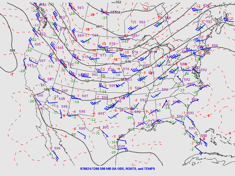
Right now my buddies are out west chasing this latest storm system. I’m not with them because I can’t afford it. Money has been extremely tight and what I take in has got to go toward paying the bills and putting food on the table for Lisa and me. That’s the reality of life. I’ve been on a couple of unproductive chases so far this year, and now that a decent system is finally in play out west, I’ve got to pass it up. I can’t even chase what promises to be a fabulous day today in Illinois. Once again I’ll be picking over the scraps later on here in Michigan. It’ll be nice to get some lightning, but it just isn’t the same.

Armchair chasers are typically regarded as off on the sidelines of storm chasing. But there’s a difference when you’ve been in the game and find yourself benched. You know what you’re missing. You’ve been looking forward to it all year with intense eagerness, like a kid looks forward to Christmas. So when you can’t do a thing about it unless it lands right in your lap–which in Michigan, land of cold fronts and veered surface winds, doesn’t happen often–it is extremely frustrating. SDS is one thing, but this is something else.

Armchair chasing? Nuts. I get to where I don’t even want to go near a radar. But I do anyway. I can’t seem to help myself. I want to see what’s happening with my friends, what storms they’re on. I look at the forecast models, too, hoping against hope that they’ll stop sticking their stupid tongues out at me and smile at me for once.

Today the RUC actually seems to do so. Here’s the 10Z KGRR sounding for 23Z this evening. Not bad. I just wish I believed that those surface winds and helicities were accurate, but I don’t, not with other models (NAM, GFS, and SREF) shouting them down. Besides, the HRRR composite reflectivity hates me. I can’t stand looking at it. Again, though, as with the radar, I do anyway. Storms progged to fire in northern Illinois and even south along the Michigan border…all I’d have to do is hop in my car, head west along I-80 and maybe down toward Peoria, or even just 80 miles south down US 131 toward the state line as a compensation prize, and I’d be in the sweet zone. But it ain’t gonna happen.

Rant, rant, rant. On this date last year I was on the most unforgettable chase of my life in northern South Dakota. Today, I wish this present system would just get on with it and get it over with so I can forget about weather, forget about the fact that I call myself a storm chaser when I’m not chasing storms. What a laugh. True, I’ll be chasing this evening locally for the first time for WOOD TV8. That I can at least afford, and it’s a nice way to work with the storms that we do get and possibly provide a bit of public service. But I don’t have high expectations. That’s a good thing here in populous West Michigan, but it doesn’t satisfy a convective jones. I just hope this season doesn’t drift into the summer pattern before I can get out and see at least one good tornadic supercell.

Okay, enough of this self-indulgent, babyish whining. I just had to get it out of my system, because in all seriousness, missing out on the action bothers me a lot, an awful lot, more than I can describe. It’s an absolutely miserable feeling. But it’s how things are, and life goes on.

Good luck out there in the Plains, Bill, Tom, and Mike–and Ben and Nick, though I know you guys are chasing separately. I hope you bag some great tornadoes today and over the next few days. As for me, it’s time to shower up, head to church, and remind myself that there’s more to life than this.

Low-Topped Supercell Images from Last Wednesday

Last Wednesday, May 11, in northwest Kansas was a bust chase as far as tornadoes were concerned. But the prairie sky offers compensations that are blue-ribbon prizes in their own right if you’ve got an eye for beauty.

Here are some shots of a couple of low-topped supercells taken in the Atwood/Oberlin area. These storms dumped some marble-sized hail and exhibited visible, though not strong, rotation. They were lovely to behold, sculptures of moisture shaped by the wind and lit by the light of the waning evening. Atmospheric dramas such as these are the true panorama of the Great Plains. Like a run-on sentence, the treeless landscape stretches off into limitless sameness, leaving the sky to provide punctuation, energy, and color.

First Great Plains Chase of 2011 This Wednesday

At last, the setup I’ve been waiting for–one that warrants dipping into my tight finances in order to make the 1,000-mile drive to the Southern Plains. To date, this present system has been a miserable disconnect between upper-level support and instability, with a nasty cap clamping down on the whole shebang. Last night it managed to cough up a solitary tornado in South Dakota. That was it. I’m not sure what today holds, but I haven’t seen anything to excite me about it or tomorrow.

But Wednesday…ah, now we’re talking! The SPC places a large section of the Great Plains under a slight risk, and their discussions have been fairly bullish about the potential for a wide-scale event. At first I couldn’t see why. My mistake–I was looking at the NAM, which with straight southerly H5 winds has not provided the best PR for Wednesday’s setup. But once I glommed the GFS, I got a whole ‘nother picture, one which the SREF and Euro corroborated.

That was last night. I haven’t looked at today’s SREF, and the new ECMWF gives me a slight pause as its now somewhat negative tilt has slightly backed the mid-levels from the previous run. But only slightly. The H5 winds still have a nice southwesterly flow, and taking the three models together, everything you could ask for is lining up beautifully for tornadoes in the plains.

The event promises to be widespread, with a robust dryline stretching from a triple point in southwest Kansas south through Oklahoma and Texas. Positioned near a dryline bulge, Enid, Oklahoma has drawn my attention for the last couple of GFS runs. Check out this model sounding for 00Z and tell me what’s not to like about it. Everything is there, including a voluptuous hodograph and 1 km SRH in excess of 300 m^2/s^2.

Other places in the region also look good, though. Farther south in Texas, Wichita Falls shows potential. Helicity isn’t as persuasive as Enid, but the CAPE tops 3,000 J/kg and there’s less

convective inhibition. Here’s the sounding for you to compare with Enid.

I haven’t been as drawn to Kansas so far, but with the triple point perched there, storms are bound to fire up just fine in the Sunflower State. The details will work themselves out between now and Wednesday evening. Significantly, the tyrannical cap of the previous few days no longer appears to be an issue.

The bottom line is–it’s time to head West! This evening I’m taking off for the plains with my long-time chase buddy Bill. At last! Time to sample what the dryline has to offer, and–now that I’m equipped with a great HD camcorder–finally get some quality footage of a tornado or two.

There’s no place like the Great Plains! YeeeeHAW!!!!!

Eyeballing Monday for Severe Weather

Thursday Night

If the GFS is in the ballpark, then Monday by the Michigan border could be a chase day. Things may look better elsewhere in the country, but I have to stay local this coming week and take what I can get. I’m not going to slap up a bunch of weather maps right now because it’s too early to be definitive and too late at night for me to want to get very involved. The NAM will kick in tomorrow, and then things will become more interesting as I compare notes with it, the GFS, and the Euro.

Right now, though, the GFS is calling for a warm front laying down by the Indiana/Michigan border, with a surface low just to the west inducing strongly backed winds in the vicinity of the boundary. A stiff H5 jet core blows directly overhead, with shear to spare. SBCAPE of 1,000 J/kg-plus will be right in the neighborhood. The wild card looks to be whether sufficient moisture and instability will make it close enough to the boundary for helicity to do its thing.

The SPC’s current long-range outlook for Monday puts all of the action well to the south, from central Illinois and Indiana down to Dixie Alley. But I’m thinking that there’s a chance for tornadoes much closer to home. Not that I’m betting on it, but I am most definitely going to be keeping a close eye on the forecast models to see how they trend over the weekend.

Update: Ugh!

As of this Friday morning, the last two runs of the GFS and now the NAM are painting a very different scenario around here from what I’ve described above. Monday’s outlook for this neck of the woods look good for storms, but with the winds unidirectional from the southwest the setup appears to be quite linear. The warm front looks to lift up into Michigan and there’s bound to be some backing of winds along that boundary, but whether they can hook up with surface-based instability is the question, and the cold front will be breathing down their neck, rocketing in and shoveling up the moisture en masse.

I should mention that this is the more hopeful picture per the NAM, which places the triple point in southwest Michigan by 18z. The faster GFS has blasted the cold front through by that time, with the low center well to the north, and the Euro is uncharacteristically even more aggressive. I had read that it and the GFS were in good agreement previously, but I don’t see that reflected here.

That’s as of the 6z GFS and NAM runs. The picture has changed, but chances are it’ll change again. The only thing to do is sit back, watch this pot bubble, and see what comes of it.

Backing Winds: Really Necessary for Tornadoes?

That’s right, fellow storm chasers, you read my headline right. I’m about to raise a few eyebrows by tossing out the possibility that backing winds–or, more precisely, what we normally consider to be backing winds as depicted on forecast maps–aren’t always vital to tornadic storms.* This isn’t speculation as much as it is observation. Over the years I’ve seen a number of tornadic events develop in the midst of southwest surface flow, enough to think that the absence of southeasterly winds on the forecast map isn’t always a deal breaker.

What is indispensable are the conditions that southeasterly boundary layer winds tend to create. I’m thinking of ample deep-layer moisture and sufficient low-level storm-relative helicity. Those are what count. If they are present, it doesn’t much matter which way the wind blows from our perspective. The atmosphere sees things differently and doesn’t care what we think. It just does what it does.

Let me quickly say, I’m a huge fan of southeasterly surface winds. I love to see them on forecast maps. And I’m aware that winds can back locally in ways that the maps don’t portray. What I’m really talking about here is forecasting using the tools we have to work with, which continue to improve. Until last year, for instance, I’d never heard of the HRRR. It’s a marvel. But generally speaking, in contemplating the prospects for a chase day we’re still dealing with pretty broad brush strokes, and the farther we live from Tornado Alley, the better we need to be at determining how those strokes will play out.

A Regional Thing?

In writing about forecasting matters, I still feel very much like a neophyte who may be getting into matters that are over my head. I’m no Jon Davies or Chuck Doswell. I’m not even a meteorology student. But you know the old saying about fools, angels, and where they tread.

My sense of things is that as we move east of the Mississippi, southeasterly surface winds become less important for moisture fetch–and, I might add, southwesterly 850s aren’t such a terrible thing. Why? For one thing, moisture sources in the Gulf of Mexico no longer lie to the southeast, but to the south, and even to the southwest in eastern parts of the CONUS. Also important, the desert southwest isn’t nearly so proximate an influence. Thus, H85 winds that would kill a setup with dry air advection in Oklahoma can carry moisture up into Illinois and Indiana. Moreover, that moisture is apt to follow a curvy path–one that can, for instance, take it first northwest from the Gulf, then north, then northeast up into the Great Lakes.

All that to say that the trajectory of moisture transport can look different in different parts of the country.

As for helicity, does it really matter whether you’ve got southeasterly, or even southerly, surface winds as long as 0-1km SRH is in the neighborhood of 150 or greater? Years of reading convective outlooks leads me to believe that the SPC doesn’t think so.  What I’m saying here is no doubt old hat to them. But it may seem a bit out of the box to at least some storm chasers, particularly those whose thinking has been conditioned by setups in the southern and central Great Plains. The whole concept of storm-relative helicity suggests that the term backing is, well, relative, a matter of how winds relate to a storm as it moves, not to the compass. That’s why right-turners produce. A few days ago in Pennsylvania, overall storm motion was consistent with unidirectional winds from the west; yet a rogue supercell deviated to the right and spun up a tornado near Greensburg.

A Few Examples

Seeing is believing. Here are a few maps that show surface conditions around the time of tornado incidents east of the Mississippi.

july-13-2004-roanoke-ilThe July 12, 2004, Roanoke, Illinois, tornado is an example of a classic northwest flow event. Rated F4, the tornado was large, long-lived, and not the first violent tornado to occur in northwest flow during the warm season in Illinois. Four years earlier, the disastrous 1990 Plainfield F5 was fueled by massive CAPE amid northwest flow.

june-5-2010-elmwood-iljune-5-ilx-pm-soundingThe June 5, 2010, central Illinois outbreak was a sort of quasi northwest flow situation. Mid-level winds were predominantly westerly with just a slight northerly component to them. The surface and 850 winds were unquestionably veered. Besides the surface map, I’ve also included the ILX 00z sounding, which preceded tornadogenesis by roughly an hour.

august-24-2007-pottervillepotterville-500mb-12zFinally, the Potterville, Michigan, tornado practically dropped in my lap, but I ignored what the radar was showing me because I was too dumb to believe my eyes even when the dynamics were plainly visible in the clouds right over my head. This was not a northwest flow event; in fact, as you can see by comparing the surface and 500mb maps, it looked to be unidirectional from the southwest, with directional shear increasing as the trough moved east and mid-level winds became more westerly.

You can find plenty more examples besides these, I’m sure. My point is simply this: Don’t be too quick to write off a synoptic setup because of veered surface winds in the forecast, particularly east of the Mississippi. If moisture is in place and there’s reason to hope for adequate SRH, then it can pay to take a deeper look. Things could pop. They’ve done so before and they’ll do so again.

_______________

* ADDENDUM, March 3, 2013: The term “backing” has a couple of different applications. I used it a bit naively in the title and copy to mean southeasterly surface winds, which is the meaning by which I first came to understand the word. That becomes apparent quickly  in the article, but it bears explaining. If I were writing this  post today, I’d simply say “southeasterly” and erase any uncertainty of what I meant.

What Do You Need to Chase Storms?

“How do I become a storm chaser?” If you’ve been asking that question, this post is for you. I write it with some reservation, knowing that there are people more qualified than I to address the topic. That being said, I’ve been chasing storms with some modicum of success long enough now that I’m confident my insights can have value for those who wonder what it takes to get started.

What do you need in order to chase storms? I’ve seen some lengthy lists developed in response to that question. The input is good, but it can overcomplicate matters, and too much of it all at once can be daunting. If you focus on the word “need,” the answer is much simpler. That’s my approach here: strip it down to the basics, then build from there.

The Foundational Stuff

Here, in my opinion, are the few things that a storm chaser cannot do without:

◊ A roadworthy vehicle, be it yours or a chase partner’s. By “roadworthy,” I mean one that can successfully manage the terrain you’ll be chasing in. If your territory is the flatlands of Illinois and Indiana, or if you intend to stay on main roads that aren’t likely to run out of pavement, then pretty much any vehicle will serve you. On the other hand, if you plan to chase down west Kansas backroads, then you’d better have four wheel drive and great tires; otherwise, the clay out there will slurp you down and ruin your day.

◊ Road maps. Self-explanatory, I think.

◊ Money. You need gas for the tank, right? And maybe a burger along the way.

◊ Basic knowledge of storm structure. Sure, you can chase storms without knowing anything about their features and behavior. But you can’t chase them safely, and the odds of your chasing them successfully are slim. So learn all you can. West Texas storm chaser Jason Boggs has created an outstanding list of educational resources that you can access as quickly as you can click your mouse. Jason’s list mixes basic and advanced material together without discriminating between them. It’s all good, but you should start with the fundamental stuff that deals with storm structure. Veteran chaser Gene Moore’s material on identifying storm features is a good first bet.

Also, a quick plug for Stormtrack, the online informational clearing house, learning resource, and virtual community for storm chasers worldwide. You’ll learn an awful lot just browsing the forum.

One final word on learning: there’s nothing like a mentor. If you can hook up with a seasoned chaser who’s willing to show you the ropes, grab the chance. You can shorten your learning curve significantly. But if such a person isn’t available to you, don’t let that stop you.

◊ Light bars for your vehicle. Absolutely mandatory. How is the world going to know you’re a storm chaser if your vehicle doesn’t resemble a mobile road block?

JUST KIDDING! Don’t worry about light bars just yet.

That’s it for the essentials. Pretty basic, aren’t they–just you, your vehicle, maps, money, and a bit of knowledge. It really doesn’t take any more than that to intercept storms. The main thing is to get out there and do it.

Assuming that you’ve got the fundamentals in place, let’s look next at a few things that will make your chases more successful and your experiences more rewarding.

Important Tools of the Trade

Can you chase storms without a laptop equipped with radar software and mobile data? Of course you can! Ask any chaser who’s been around ten years or longer and they’ll tell you. When the pioneer chasers began paving the way for the rest of us, they did it without all the trimmings. Even Rain-X wasn’t trademarked until 1972, and David Hoadley was chasing storms long before then.

For that matter, I didn’t have any of the following tools of the trade for many years during my own illustrious ascent as a storm chaser. Of course, I didn’t see any tornadoes, either, so don’t take your cues from me. I will tell you that I had a lot of fun learning the slow, hard way. However, my successes came when I started adding a few resources, concurrent with improving my knowledge of forecasting and storm morphology.

All that to say that while the items below aren’t absolutely indispensable, that doesn’t mean they’re not important. They’re very important, and not many chasers today, including the veterans, chase without them.

◊ Laptop computer. It’s your control center.

◊ Power inverter to power your laptop and charge your cameras.

◊ Radar software. Besides a laptop, this should be your first purchase on the list of storm chasing tools. I recommend GR3, at least to begin with. It’s the one used by most chasers, and for good reason: it’s a fabulous program designed specifically for storm chasing, with incredible functionality and flexibility. Just get it, okay? For $80, trust me, you can’t go wrong. For that matter, you get a free trial period that lets you play with the program for a few weeks before you slap down your money.

◊ USB modem and mobile Internet connection. Your best bet is to purchase a USB modem outright; that way you’re not locked into a 2-year contract, and you can deactivate your account during the off-season instead of continuing to pay for data you’re not using. As for Internet connection, Verizon currently provides the best data coverage nationwide, and a lot of chasers use it. Others prefer Sprint, also a good choice. Where you’ll be chasing is something to consider in making your decision.

◊ Radar data feed for GR3. You can use the free feed that NOAA provides. But a lot of chasers prefer a dedicated feed such as those provided by Allisonhouse and MichiganWxSystem. Priced around $10 a month, such a feed is well worth the money.

Nowadays more chasers are using Android phones with radar apps. Not being the geeky type, and also not having the cash, I haven’t looked into these setups. I like having a large display in front of me anyway instead of a tiny screen, but I’m not knocking those who are working with with handheld units. The point is, however you get it and however you display it, you want good, detailed radar information delivered to you with timely updates.

◊ GPS and mapping software such as De Lorme. You’ll also want a serial port emulator that will allow you to use GPS simultaneously with both your map and your radar.

◊ Rain-X. Worth every dollar it costs, and it doesn’t cost much.

SPC Convective Outlooks link. After all, all your great gear doesn’t amount to squat if you can’t find storms! Since you’re new to storm chasing, chances are you don’t have the knowledge to make your own forecasts. Start acquiring it now, beginning with the Storm Prediction Center’s convective outlooks page. It will do two things for you: 1) show you graphically whether and where storms are expected to fire, and 2) through its detailed forecast discussions, familiarize you with the terminology and thinking that go into severe weather forecasting.

◊ Light bars. Don’t leave home without them. How will drab, ordinary, non-storm-chasing mortals know you’re a storm chaser unless…oh, hey, wait a minute. Sorry, we’re still jumping the gun. Forget I mentioned light bars. You don’t need light bars. Not now, anyway. Patience, patience!

Moving On

◊ Station obs, upper air maps, and other forecasting data. Here’s where it gets fun! Making your own forecasts is what separates the be’s from the wannabe’s, and sooner or later you’ll want to try your hand at it. Luckily for you, a cornucopia of forecasting resources is available to you for free online. So start acquainting yourself with the tools of the trade. Check out the tabs at the top of my Storm Chasing page for starters. Also, take a peek at the resources available on my friend Kurt Hulst’s site, Midwest Chasers.

◊ Anemometers, weather meters, and other gadgets. Once you start chasing, you’ll soon run into vehicles tricked out with various devices useful for personal monitoring of wind speed, wind direction, moisture, barometric pressure, and other localized weather conditions. You don’t need any of this stuff in order to enjoy success chasing storms. But depending on how deep and techy you want to get, you might decide that some of it is for you. Just get it for the right reason: to enhance your chasing, not to impress the world with a mess of whizbangs and dingdongs ornamenting the top of your vehicle.

Me, I like to keep things simple. Nothing about my car shouts “storm chaser,” and the only gadget I use is a Kestrel 4500 hand-held weather meter. It’s a cool little device, a regular Swiss Army Knife filled with all sorts of nifty features that I don’t need. I use it mainly to get local, real-time reads on the dewpoint, temperature, and wind speed, information that I do find very useful.

◊ Camera and/or camcorder. A no-brainer if you want to capture visual images of your chases.

◊ Communication equipment. While it probably goes without saying, you should at least carry a cell phone with you. A lot of chasers are also HAM radio operators, and this spring I’ll be joining their ranks with a hand-held unit of my own. I’ve chased for fifteen years without HAM, but I’ve seen the benefits of having it.

◊ Spotter Network. A service of Allisonhouse, Spotter Network interfaces with your radar software and GPS to show other chasers where you’re at and to show you where everyone else is positioned. More importantly, it allows you to quickly and efficiently submit reports of severe weather online from your location.

◊ “NOW can I have a light bar? Can I? Pleeeeze?”

Oh, good grief. Yes, fine, all right, go, get your precious light bar if you must. Buy seven or eight of the damn things. Pick up a spotlight or two while you’re at it. Perish forbid that you should settle for anything less than the candlepower of a NASA launch pad.

My serious opinion: any gadgets you purchase should have a genuinely practical application. I don’t own a light bar myself because I don’t need one. I’m not trained as a first responder, and in the event of an emergency, my best response normally won’t be to clear the road for myself or alert others to my presence, but to get the heck out of the way of emergency personnel who need to get through.

You, on the other hand, may in fact have medical or emergency training and a legitimate use for a light bar. If so, then get one. If not, what’s the point?

And this leads me to comment on one final, vitally important aspect of storm chasing…

Your Attitude

Even as storm chasing has captivated the public through documentaries and reality TV shows, it has also gotten a black eye in some parts of the country due to the misbehavior of irresponsible yahoos. More of these jokers are surfacing all the time. So let’s be clear: chasing storms does not give you license to act like a self-centered idiot. Use common sense. You don’t own the road, so drive safely and respectfully. If you want to stop and film, find a safe place to pull aside so you don’t impede traffic. Drive at a sane speed that doesn’t endanger others, and bear in mind that hydroplaning is a more serious danger to chasers than tornadoes.

Also, have some respect for people who have been chasing for a while. Some experienced chasers have expressed disgust, anger, and disinclination to continue sharing their knowledge after encountering know-nothing newbies who think they know it all. So remember, as a neophyte you’ll earn respect by showing respect. Humility, a thirst to learn, and passion for the storms will get you places that posturing and arrogance never will.

‘Nuff said. Good luck, stay safe, and have fun.

It Was a Dark and Stormy Night, But the Band Played On

Happy New Year! Last year was tough but we made it through, didn’t we. I hope that 2011 will be a good year for you, for me, for us all.

Yeesh, I’m starting to talk like Tiny Tim. I’d better get on with this post, which is a summary of yesterday. Weatherwise, the last day of 2010 was a humdinger for convective connoisseurs, and jazz-wise, it was a fun evening for yours truly. While the two topics may seem unrelated, they are in fact integrally connected. It’s a well-known fact among my storm chasing buddies that any time I commit myself to a gig and am therefore unable to chase, tornadoes will drop out of the sky like confetti at a gala event. It’s a gift I have. Statistically, my powers hit their zenith the weekend of the Grand Rapids Festival of the Arts in early June. But anytime of the year, all hell is liable to break loose when I’m booked to play somewhere.

Yesterday was a prime case in point. While Steve Durst and I played a thoroughly enjoyable piano-sax gig for the dinner crowd at the Cobblestone Bistro here in Caledonia, tornadoes mowed across Missouri, Illinois, and Mississippi. You could see the event shaping up earlier in the week, with forecast models depicting a potent longwave trough digging deep into the nation’s midsection on Friday; a surface low working its way northward through Missouri and Iowa; high-velocity mid- and upper-level jets generating massive shear; and, critically, a long and broad plume of unseasonably rich moisture juicing the atmosphere up into Illinois ahead of an advancing cold front.

If you want to get some great insights into yesterday’s setup compared with two other similar wintertime severe weather events, check out this superb article by Adam Lucio in Convective Addiction. Adam’s analysis was spot-on. Tornadoes began spinning up early yesterday morning in Oklahoma and Arkansas and continued on through the day in Missouri and Illinois, surprisingly far north. Rolla and Saint Louis, Missouri, got whacked pretty solidly. Later, as expected, the action shifted south, with severe storms firing in Louisiana and a batch of night-time tornadoes gnawing their way across central Mississippi. Yazoo City found itself in the crosshairs for the third time this year as a strong radar couplet grazed past it, but, mercifully, this time the town appears to have escaped yet another direct hit.

With yesterday’s dust finally settled, the SPC’s present tally shows 40 preliminary tornado reports. Sadly, there were some fatalities, not all of which the reports show. What an awful way for the families affected to end a year that has already been difficult enough for so many people.

And the show isn’t quite over. Today, on the first day of 2011, Tornado Watch #3 is in effect for the Florida panhandle and southern Alabama. If that’s any kind of augur for this year’s severe weather season, April through June could be an interesting time for storm chasers.

But enough about the weather already. Let’s talk about jazz.

The Cobblestone Bistro is a beautiful place to play. I can’t believe that something like it exists in Caledonia, a community not exactly renowned as either a jazz hot spot or a north star of destination dining. But here the bistro is, fully operational now that a long-forthcoming liquor license has put its winsome and comfortable bar in business, and with an owner who appreciates and supports live jazz.

Last night I played my first gig at the Cobblestone for the New Years Eve dinner crowd from 6:00-10:00 p.m. Steve Durst joined me on the keyboards, and we spent an enjoyable four hours playing jazz standards in as elegant and ambiance-rich a setting as you could hope to find.

In a restaurant, particularly in a smaller room, it’s important not to play too loudly. People want to talk, and the music needs to add to the mood, not subtract from it by being too intrusive. That can be tricky for a sax player. A saxophone is not by nature a shy, quiet instrument, and a lot of energy is required to play it softly. But with three tables positioned directly in front of Steve and me, both of us absolutely had to reign in our volume.

Evidently we succeeded. We got no complaints of playing too loudly, but we did get some very nice compliments on our sound.

I’ll be playing at the Cobblestone again next Saturday, January 8, from 6:30-9:30 p.m. with Dave DeVos on bass and Paul Lesinski on keyboards. The trio will be playing as well on the 15th and 22nd, with Steve occupying the keyboard seat on the 15th. If you’re looking for a great night out in a beautiful setting, come and check us out.

And with that, I’m signing off and getting this first afternoon of a brand new year underway. I wish you a very happy and prosperous 2011.

–Storm (aka Bob)

A Stormy New Years Eve in the South?

slp-gfs-123110slp-nam-123110Could be. If the GFS is right, the chance of severe weather in the Gulf states looks good. The NAM too, having leaned in with its 12Z run, also points to the possibility of a New Years Eve episode down in Dixie Alley, though it wants to nudge the ingredients slightly to the west and north.

sfc-tds_mlcape-gfs-123110sfc-tds_mlcape-nam-123110So far the SPC appears to believe that severe weather is likely in the South on Friday, but while they’ve mentioned the T-word, tornadoes, they’ve been reluctant to say anything emphatically. Of course, we’re still four days out, and hitherto the forecast models evidently haven’t jibed (I haven’t followed the trends till now). But between this 500mb-heights-gfs-123110500mb-heights-nam-123110morning’s GFS and NAM, it looks like a pretty decent intrusion of moisture will lick inland from east Texas eastward to Florida, with 500 J/kg MLCAPE overlaid by ample shear as a large mid-level trough digs into the nation’s midsection. From the looks of things, Louisiana, Arkansas, and Mississippi could be in the crosshairs, and eventually, 500mb-winds-gfs-123110500mb-winds-nam-123110perhaps Alabama and the Florida panhandle.

Here are some GFS and NAM models for you to compare. Left-click on the thumbnails to enlarge them. I’ve used the model runs available to me at this writing on F5 Data–6Z for 6km-shear-gfs-1231106km-shear-nam-123110GFS and 12Z for NAM. The valid times should read 18Z, not 17Z.

.


MetEd: A Fantastic Self-Educational Approach for Learning Weather Forecasting

When I first began turning my lifelong fascination with tornadoes into an active passion for storm chasing over 14 years ago, I started with the essentials of storm structure. Then I began learning such arcane terms as CAPE, shear, dewpoints, helicity, and so forth, over time piecing together how the different ingredients interact. Bit by bit, the alchemy of the atmosphere–depicted by surface maps, forecast models, skew-T/log-P diagrams, hodographs, station obs, satellite, radar, and other mystifying tools of the trade–began to make sense to me. Tremblingly, nervously, with a deep sense of my woeful lack of knowledge, I began to try my hand at forecasting–and darned if I didn’t start to make some good calls.

Slowly I learned, and I’m still learning. There’s so much to know, and I want to know as much as I can in order to more accurately determine whether there will be tornadoes, and where, and at what time, and whether a weather scenario will be significant enough to warrant the long drive from Michigan to wherever the storms will be firing.

I wish I’d had a mentor to help me learn this stuff. Thank goodness for the community on Stormtrack–for the many experienced chasers and meteorologists who have generously answered my questions and shared their knowledge over the years! Fortunately for new chasers, a wealth of educational resources exists today that can make the learning curve quicker and less frustrating.

And that brings me to MetEd

I just completed a MetEd satellite interpretation module on vorticity maximas and comma clouds. The material has both enlightened me and kicked my butt. I’ve learned enough to know that I’ve got a lot to learn, but also enough to make better use of water vapor imagery. Now I’m moving on to vorticity minimas, but after finishing the first module I had to just back away for the evening and take a breather. This stuff may seem simple to some, but it makes me want to find a nice hard surface and bonk my head against it. I get the concepts, but working them out in real-life case studies is something else. What gives me incentive is the payoff of becoming a better forecaster. MetEd offers some fantastic tools for pursuing that goal.

Short of a formal education in meteorology, MetEd online courses are probably the best thing going for those who want to acquire basic forecasting skills or expand the skills they’ve already got. I recommend them highly. A program of UCAR (University Corporation for Atmospheric Research), MetEd is no lightweight survey. It’s a constantly growing and evolving suite of vanguard educational products covering a broad sweep of meteorological topics, and it is used by scores of operational forecasters to help them sharpen their blades. Predictably, some of what it offers is well beyond the grasp of most lay persons. Yet a fair amount is accessible to the motivated self-educator, and well worth the time it takes to absorb the material.

The course I’m working on, Dynamic Feature Identification: The Satellite Palette, is a good example. Its interactive format lets you get your hands dirty with actual application as you learn about vort maxes, vort minimas, comma clouds, deformation zones, blocking patterns, and more. Once I’ve completed the full course, while I’ll assuredly be no expert at interpreting water vapor imagery, I’ll nevertheless have gained some knowledge that will serve me well–stuff I’ll be able to use next spring when Big Weather returns to the Great Plains.

If you want to bone up on weather forecasting of any kind, from severe thunderstorms to winter weather and more, you owe it to yourself to check out MetEd. Do it now and you can thank me later for sending you. MetEd is a great way to hone your skills during the long stretch between now and Storm Season 2011.

Multiple Vortices: How Deep Do They Go?

In a recent thread on Stormtrack, storm chaser Shane Adams speculated that all tornadoes exhibit some degree of multi-vorticity. He opened up a topic that has intrigued me for a while.

Just how deep does multiple vorticity extend into a tornado? It may go deeper than most of us chasers imagine. We all understand that many tornadoes display multiple vortices, and a lot of us have witnessed the phenomenon firsthand. It’s possible, though, that the process we call a tornado is a actually an entire complex of vorticity consisting of rotations within rotations. It’s no secret that circulation ranges downward from synoptic scale to mesoscale to microscale; why shouldn’t it continue to do so on increasingly smaller scales? Maybe this concept is nothing new to tornado researchers, but I haven’t heard it discussed to any degree in the general storm chasing community.

While I used to associate multiple vortices with larger tornadoes, it’s the smaller ones that in recent years have intrigued me as I’ve taken a closer look. Some of the more transparent tornadoes have revealed fascinating inner structures, including a sheath-like outer wall cloaking a vigorous center, and a sort of braided appearance that has made me think of the strands that weave together to compose a rope. The 2007 Elie, Manitoba, F5 drillpress is a good example. Check out this video and I think you’ll see at least some of what I’m talking about, particularly around 4:17 into the clip.

Another video of this same tornado, shot at a closer location, offers an excellent front-row view of the tornado as it dissipates. Unfortunately, I can no longer locate that video on YouTube, and I really wish I could, because as I recall, the close-up of the tornado in its last couple of seconds amazed me. The funnel appeared to unravel; for a brief moment, you could see it separate into what I’m going to call vortex strands as its energy abruptly gave out, following which it simply vanished. As striking as how quickly the tornado transformed from a town-wrecker into nothingness was the manner in which it did so.

More recently, I finally got a good firsthand look at extensive, small-scale vortices on May 22 this year in South Dakota. The much smaller, highly photogenic tornado that followed the massive and violent Bowdle wedge was a shape-shifter that went through some fascinating transitions. Parking itself in a field a mile northwest of our vantage point, unobscured by rain, it was beautifully visible and offered a study in multiple vorticity throughout its life. For me, the high point was when the funnel assumed the form of a truncated tube, with delicate tendrils of condensation circulating underneath it one after the other like horses on a merry-go-round. (My thinking is that a pocket of drier low-level air stripped out condensation except in the places where the vortex strands rendered the pressure low enough to make themselves visible.)

In the photo (click on the image to enlarge it), some of the vortices are apparent, but if you look closely, you’ll notice that some of the larger vortices actually appear to be made up of more than one vortex strand. You’ll also see a tendril or two appear to branch off. In all, I’m able to make out eleven strands, ranging from the obvious to the nearly undetectable. Granted, I may be pushing things; my point is that the circulations in this tornado were numerous, varied in scale, and complex. I suspect that there were even more vortices present than meets the eye, but I’m not going to force the issue because I’m no scientist, just a thoughtful observer with an aversion to crackpotism.

If there’s any recent weather-related post on this blog that I hope will draw some solid, informed comments, it’s this one. I’d love to get the opinions of others in the storm chasing community; and while I don’t expect that it will happen, I’d be extremely interested in hearing from those who are actually involved in tornado research.