Eyeballing Monday for Severe Weather

Thursday Night

If the GFS is in the ballpark, then Monday by the Michigan border could be a chase day. Things may look better elsewhere in the country, but I have to stay local this coming week and take what I can get. I’m not going to slap up a bunch of weather maps right now because it’s too early to be definitive and too late at night for me to want to get very involved. The NAM will kick in tomorrow, and then things will become more interesting as I compare notes with it, the GFS, and the Euro.

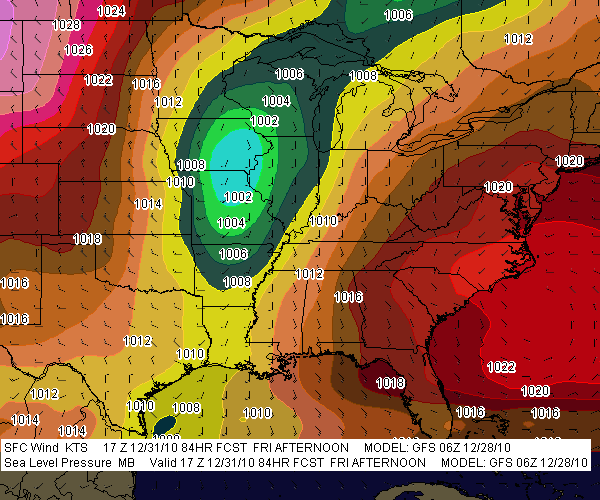
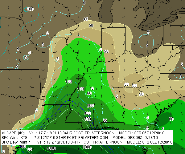
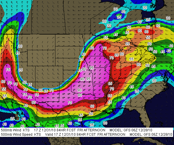
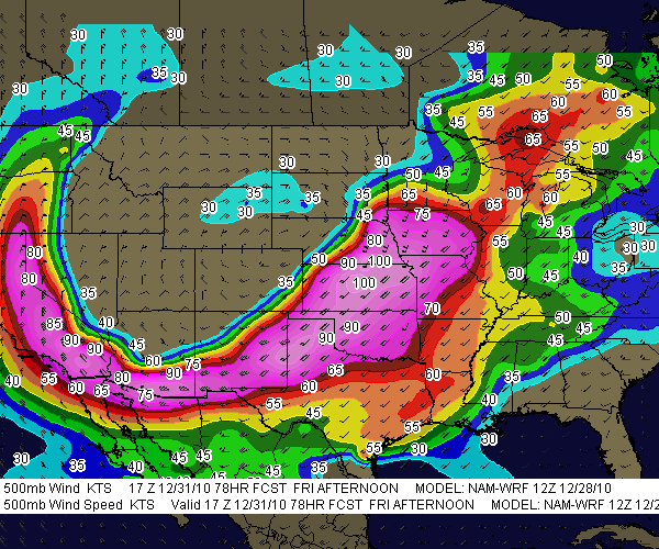
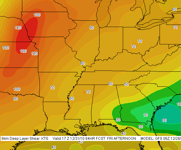
Right now, though, the GFS is calling for a warm front laying down by the Indiana/Michigan border, with a surface low just to the west inducing strongly backed winds in the vicinity of the boundary. A stiff H5 jet core blows directly overhead, with shear to spare. SBCAPE of 1,000 J/kg-plus will be right in the neighborhood. The wild card looks to be whether sufficient moisture and instability will make it close enough to the boundary for helicity to do its thing.

The SPC’s current long-range outlook for Monday puts all of the action well to the south, from central Illinois and Indiana down to Dixie Alley. But I’m thinking that there’s a chance for tornadoes much closer to home. Not that I’m betting on it, but I am most definitely going to be keeping a close eye on the forecast models to see how they trend over the weekend.

Update: Ugh!

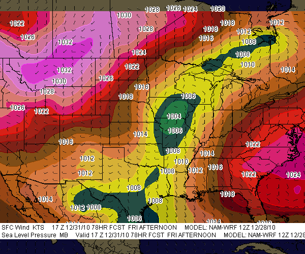
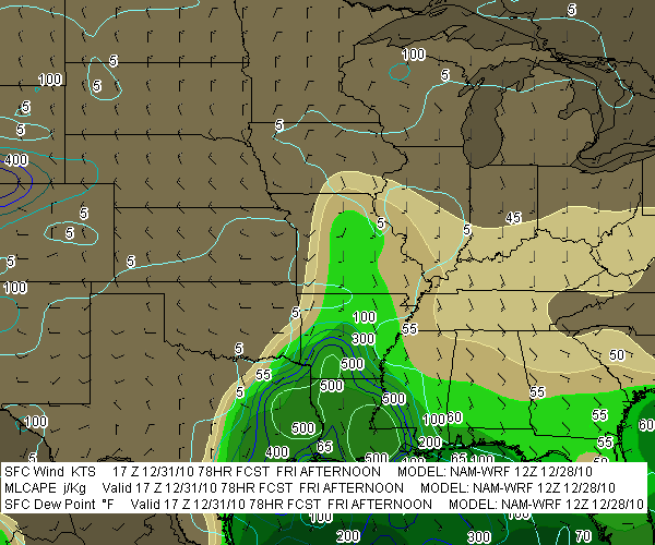
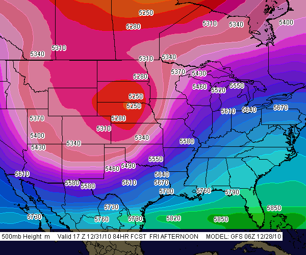
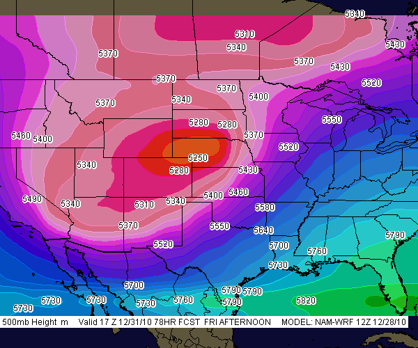
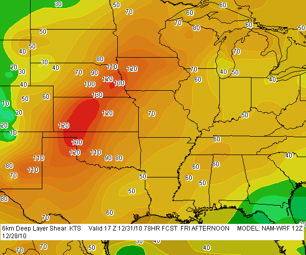
As of this Friday morning, the last two runs of the GFS and now the NAM are painting a very different scenario around here from what I’ve described above. Monday’s outlook for this neck of the woods look good for storms, but with the winds unidirectional from the southwest the setup appears to be quite linear. The warm front looks to lift up into Michigan and there’s bound to be some backing of winds along that boundary, but whether they can hook up with surface-based instability is the question, and the cold front will be breathing down their neck, rocketing in and shoveling up the moisture en masse.

I should mention that this is the more hopeful picture per the NAM, which places the triple point in southwest Michigan by 18z. The faster GFS has blasted the cold front through by that time, with the low center well to the north, and the Euro is uncharacteristically even more aggressive. I had read that it and the GFS were in good agreement previously, but I don’t see that reflected here.

That’s as of the 6z GFS and NAM runs. The picture has changed, but chances are it’ll change again. The only thing to do is sit back, watch this pot bubble, and see what comes of it.

A Stormy New Years Eve in the South?

slp-gfs-123110slp-nam-123110Could be. If the GFS is right, the chance of severe weather in the Gulf states looks good. The NAM too, having leaned in with its 12Z run, also points to the possibility of a New Years Eve episode down in Dixie Alley, though it wants to nudge the ingredients slightly to the west and north.

sfc-tds_mlcape-gfs-123110sfc-tds_mlcape-nam-123110So far the SPC appears to believe that severe weather is likely in the South on Friday, but while they’ve mentioned the T-word, tornadoes, they’ve been reluctant to say anything emphatically. Of course, we’re still four days out, and hitherto the forecast models evidently haven’t jibed (I haven’t followed the trends till now). But between this 500mb-heights-gfs-123110500mb-heights-nam-123110morning’s GFS and NAM, it looks like a pretty decent intrusion of moisture will lick inland from east Texas eastward to Florida, with 500 J/kg MLCAPE overlaid by ample shear as a large mid-level trough digs into the nation’s midsection. From the looks of things, Louisiana, Arkansas, and Mississippi could be in the crosshairs, and eventually, 500mb-winds-gfs-123110500mb-winds-nam-123110perhaps Alabama and the Florida panhandle.

Here are some GFS and NAM models for you to compare. Left-click on the thumbnails to enlarge them. I’ve used the model runs available to me at this writing on F5 Data–6Z for 6km-shear-gfs-1231106km-shear-nam-123110GFS and 12Z for NAM. The valid times should read 18Z, not 17Z.

.


Sandhill Cranes

The GFS continues to show hopeless ridging throughout most of October. I hardly pay any attention to the long-range forecast models these days, just mention this as a note of idle interest. A trough does finally seem to shape up around 300 hours out per the 6Z run, and it could make life interesting within reach of Great Lakes storm chasers on the 27th and/or 28th. But I don’t have the heart to wishcast that far out; I just don’t believe it’ll happen..

As for the saxophone, I’m extremely pleased with my personal progress. But while I’ve been practicing a lot, my sessions have involved material I’ve already covered in previous posts, and I’d imagine the results interest me far more than they would you.

Lacking anything of great import to write about concerning either jazz saxophone or storm chasing, my radar is scanning for a topic that’s at least conceivably related to either of those two interests. Yesterday’s earthquake in Norman, Oklahoma, would do well except I wasn’t there. I hear it was a loud one, but I’ll leave the reportage to those who actually experienced the shakeup. As for me, I need something closer to home. Like sandhill cranes.

Here in Michigan, now into November is the time of year when the cranes congregate in great numbers in suitable locations that offer nearby sources of both food and cover. Sometime next month they’ll take off for warmer climes in southeastern Georgia and Florida. Meanwhile, this ridging that has quashed the so-called “second season” for storm chasers has provided glorious weather for the sandhill cranes and sandhill crane watchers. The Baker Sanctuary northeast of Battle Creek and the Phyllis Haehnle Memorial Sanctuary near Jackson are well-known staging areas for massive numbers of the birds. However, I’m fortunate to have a location much closer by where over 100 cranes hang out, foraging in a field across the road from a marsh where they shelter for the evening.

Mom and I went out there Sunday evening. It was a blessing to spend the time with my sweet 85-year-old mother, watching the sandhills feed; listening to their captivating, ratcheting calls; witnessing their sporadic, comical, hopping dances; and waiting for them to take off and fly overhead en-masse into the marsh at sundown. Here are a few photos for you to enjoy.

So Much for Thursday in Illinois

I was hoping, really hoping, that this Thursday would shape up as my first chase day of the year out in Illinois. The NAM sure looked promising for a second, but now, like Dante’s inferno, it has “Abandon all hope, ye who enter here” written over the door.

The GFS was never very positive to begin with, but at this time of year, Great Lakes chasers are optimistic out of sheer desperation, and I guess I wasn’t the only one who was rooting for the NAM with its bullish CAPE of up to 1,500 j/kg and sweet lapse rates.

But it’s gone, all gone. Yesterdays NAM runs weakened the CAPE and shuttled it south and east. A nice cold core setup in southeast Iowa/northwest Illinois materialized long enough to whisper sweet nothings, but nothings are probably all they were. The 500 mb low has since slunk apologetically back west toward Kansas City, with its -25 C temperature minimum well displaced from the surface moisture lobe. The setup could still change, but unless it bumps back east and stacks back up, I’m not going to drive that far to find out.

I will, however, very likely head toward the Michigan border around New Buffalo. Moisture looks to be ample with mid- to upper-50s dewpoints augmented by evaporation, backed surface winds, and precip breaking out by 21Z if this present NAM verifies. If it does, there could be a bit of lightning and thunder, and at least the slim possibility of a brief spin-up; if not, it’ll have been a pleasant break-in drive for chase season 2010.

First Crack at Severe Weather (Has the GFS Ever Lied?)

no images were found

Here on the last day of February–just one day before meteorological spring begins–temperatures are finally settling into a warming trend here in Michigan. With plenty of snow still on the ground but the promise of better days in sight, and with me feeling my repressed itch for severe weather beginning to surface too insistently not to scratch, I’ve cast a wistful eye on the long-range GFS.

At 180 hours out from today’s 6Z run–in other words, on March 7, early afternoon–things look interesting. Not inspiring, just something to keep an eye on. If you’re a

no images were found

fellow storm chaser, you know the drill, and you know how the models change. With that caveat, while I haven’t been an avid follower of the GFS these days, I seem to recall that it was painting a somewhat similar scenario last week.

Anyway, here are the surface maps for sea level pressure and surface dewpoints at 18Z, March 7. Click on the images to enlarge them. Obviously the moisture could stand improvement, and I wonder whether sea surface temperatures in the Gulf will be warm enough to deliver, but let’s see what happens from here.

Major Winter Storm in Progress out East: Big Snow South of the Big Apple

no images were found

Which version of snowfall totals do you prefer–the NAM on the right, or the GFS, shown below? (Click images to enlarge.)

If you live out east, the question is purely academic. I doubt that you much care which forecast model is the more accurate, because either way, you’re going to be sitting under a ton of snow by tomorrow. That much is no secret. While the forecast models shown here are for 00Z Saturday night, the show has already started.

Farther down the page, you can see a level 2 radar grab from Sterling, VA, taken shortly after 10 p.m. It’s much prettier to look at than the picture

no images were found

that is unfolding over the nation’s capitol as I write in the form of heavy snow, freezing fog, mist, freezing rain, blustery winds, blizzard conditions–just about every kind of winter weather you can throw at one area in the space of a few miles as temperatures drift from below to above freezing.

The current Baltimore forecast for tonight and tomorrow reads as follows:

Tonight: Snow and areas of blowing snow. The snow could be heavy at times. Low around 29. Breezy, with a east wind between 16 and 23 mph, with gusts as high as 37 mph. Chance of precipitation is 100%. Total nighttime snow accumulation of 15 to 21 inches possible.

Saturday: Snow and areas of blowing snow. High near 29. Blustery, with a north wind between 18 and 22 mph, with gusts as high as 37 mph. Chance of precipitation is 100%. New snow accumulation of 4 to 8 inches possible.

no images were found

Ugh! For once I’ll take a Michigan winter forecast over what’s being served up elsewhere. Right now my friend Kathy out there in Greenbelt, MD, is getting her clock cleaned. It’s a good night for her and her boyfriend to eschew the Washington nightlife and hunker down inside. For that matter, I doubt there’s much happening in the way of a Washington nightlife on a night like tonight.

Meanwhile, down in the warm sector, much of eastern North Carolina is under a tornado watch. The radar shows a pretty grungy-looking, non-severe, low-topped squall line that doesn’t show much likelihood of putting out anything tornadic, but it nevertheless adds to the East Coast’s overall weather ambience.

Have fun out there, kiddies, those of you who live out east. As for me, I’m going to pour me a mugful of Bell’s Amber Ale and, for once, enjoy watching the snow not fall outside my window. Gloating over such things is permissible for lifelong natives of the Great Lakes.

Friday’s Outlook: A Real October Leaf-Stripper

Whichever model gives the more accurate picture–the GFS or the WRF-NMM–one thing is sure: we Michiganians can say good-bye to the leaves. This Friday’s weather system promises to be a real October leaf-stripper, with a formidable low-pressure center deepening rapidly as it moves through Ontario.

The two forecast models continue to differ in timing, with the GFS moving the cold front rapidly through the state’s mid-section by 18Z, while the NAM plays it more conservatively and backs the surface winds considerably more. The NAM is also much more aggressive with 850 mb winds, with the 12Z run calling for 75 knots (!!!), while the GFS dribbles out a paltry 55-knot LLJ.

I have a hunch that the GFS is closer to the truth, though of course, time will tell.

Both models agree that instability will be non-existent. Not much there to gladden the heart of a storm chaser. But by golly, we’ll be seeing some wind. Bye-bye leaves!

For the sake of comparison, I took a sampler of 6Z model soundings for both the GFS and the NAM for Jackson, Michigan–a nice, central location that should offer a good compromise between both models. The differences are striking. Click on the images to enlarge them. For 21Z, I’ve shown only the NAM; by that time, the GFS has the winds lined out.

Forecast hours for Friday, October 30

15Z

GFS

NAM

18Z

GFS

NAM

21Z

NAM

The Farmers’ Almanac, Woolly Bears, and Government Cover-Ups

Given the unreliability of long-range forecast models, there’s a lot of justifiable skepticism in the storm chasing community when someone (like me, for instance) talks about an event that’s 120 or more hours out. Beyond maybe three days, trying to forecast weather events becomes increasingly like reading tea leaves. We watch the ECMWF and GFS for signs of agreement and consistency, and if they start showing up, we cross our fingers, knowing that a lot can happen between now and payday.

So I’m not sure what to think when the revered Farmers’ Alamanac gazes into its crystal ball and issues with serene confidence the following prognostication for the Great Lakes region:

November 2009
1st-3rd. Sunny, with increasing clouds. 4th-7th. Rain spreads in from the west. Turning clear and frosty. 8th-11th. Rapid temperature changes. Storm moves east, with heavy rain or wet snow. Frigid cold air follows. 12th-15th. New storm moves into Great Lakes. Heavy rain and/or wet snow. Then clearing and very cold. 16th-19th. Storm sweeps across the area, followed by very cold air. Fast-moving storm, reaching the region by the 19th. Heavy snow, followed by colder air. 20th-23rd. Cold Canadian front brings rain and thunderstorms for the Great Lakes region. 24th-27th. A wet Thanksgiving.  28th-30th. Few rain or wet snow showers. Turning colder.

December 2009
1st-3rd. Rain and wet snow shift into the Great Lakes, south to Kentucky, followed by clear and cold weather. 4th-7th. Storm Ohio River Basin deposits heavy rain and wet snow. Very cold air follows. 8th-11th. A “winterlude” for Great Lakes and the Ohio River Basin. Temperatures still well below seasonal norms. 12th-15th. Scattered snow showers and flurries. 16th-19th. Considerable cloudiness over most areas, but little precipitation. Nights are seasonably cold, days are mild. 20th-23rd. Rain and/or snow.

Not being a climatologist, I’m unaware of what sophisticated meteorological resources the Farmers’ Almanac may be tapping into. Possibly they’ve been consulting woolly bear caterpillars. According to folklore, you can tell how severe the winter will be by the ratio of brown to black banding on the woolly bears. Plenty of brown means a mild winter; wide black bands with little brown points to a nasty snow season. A few weeks ago, I found an all-black woolly bear. I knew that couldn’t be good.

If only we could get the woolly bears to cooperate when storm chasing season is underway. But the little critters have other things on their minds by then, namely, pupating and becoming Isabella tiger moths. So I guess we’re stuck with the Euro and the GFS. Or sacrificing chickens, though the research supporting the link between chicken sacrifice and improved storm intercepts is slim.

No doubt the government is covering up the information, just like they do everything that’s related to severe weather. They want us to remain ignorant, unsuspecting guinea pigs while the weather gods at Norman conduct their insidious experiments, using their array of antennas and radars to generate monster tornadoes 400 miles away and then guide them unerringly through populated areas. Take the May 13 Kirksville, Missouri, tornado, for instance. That one had Government Issue written all over it. The lack of a single shred of substantiating evidence just goes to show how expert Big Brother is at keeping the truth hidden.*

That’s why you’ll find no NOAA papers correlating tornado outbreaks and chicken sacrifice. Same with woolly bears and long, hard winters–though the Farmers’ Alamanac folks, bless their hearts, have obviously made the connection, and hence, they have the weather for November and December pretty well locked in. I call that kind of forecasting ability reassuring.

As for the rest of us, well, we’ve got the ECMWF, the GFS, and tea leaves. How do you like your tea?

_______

* The following disclaimer is intended only for those who take me seriously: I’M JUST KIDDING! Sad that I’ve even got to say it, but the truth is, some folks out there do in fact believe some damn crazy things about the government’s ability to manipulate the weather. I’m not one of them, and I wouldn’t want to be mistaken for such.

That being said, I would love to see the SPC’s research on chicken sacrifice and tornadogenesis.

Tomorrow’s Chase Scenario

If I were to pick a chase target for tomorrow, it would be Rolla, Missouri. That’s based on a sampling of the 6Z model soundings of the GFS, NCEP’s present model preference.

Frankly, though, I can’t get too excited about this system. True, it seems to be shifting the activity to within striking distance, where I could conceivably go chasing and still make it back Friday morning in time to make an appointment that I absolutely can’t miss. But instability isn’t all that great, and besides, who wants to go chasing in Missouri hill country?

If the NAM verifies, things will shift north a bit. But I don’t see that making a practical difference. It’s a marginal setup at this point, and unless things improve, I don’t think I’ll feel short-changed sitting this round out. Maybe the next trough will be an improvement.

ADDENDUM: Ouch! Just looked at the SPC’s afternoon update. If they’re right, then only the desperate and the insane will be chasing tomorrow. They’ve pulled the 30 percent risk down mostly into Arkansas, tapping on southeast Oklahoma, northeast Texas, and extreme southern Missouri down around Branson. Anyone for a chase through the Ozarks?

Crystal Ball Gazing with the GFS

Yesterday’s trough passed through pretty much as expected, without a whole lot of fanfare and certainly not with anything tornadic. So the question is, what lies ahead? Anything?

Maybe.

At least we’re not locking in under another ridge. Today is the first day of autumn, the weather patterns are changing, and the GFS and ECMWF seem to agree on a 500 mb trough affecting the Midwest over the next several days. And yeah, yeah, I know it’s just reading tea leaves, but here are a couple 132-hour GFS maps for next Sunday at 00Z. At the risk of stating the obvious, click on the images to enlarge them. The first shows sea level pressure (shaded), surface wind barbs, and 500 mb height contours.

The second map shows 500 mb winds (shaded) with wind barbs, and 300 mb wind contours.

The big question mark may be moisture. But this far out, it’ll be nice if that even matters by the time Sunday arrives. This time of year, living in the Great Lakes, the best one can do is hope. But there’s nothing wrong with hoping.