An Interview with The Weather Channel

Henryville High School
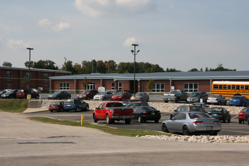
You’re looking at the Henryville, Indiana, high school, photographed from across the street on September 30, 2014. By all appearances, there’s nothing remarkable about it. But if you’re aware of its recent history, then you know differently. Two and a half years ago, on the evening of March 2, 2012, there wasn’t much left of this building or, for that matter, a good part of Henryville. Roaring out of the southern Indiana hills and across I-65 to the west shortly after three o’clock that afternoon, a large tornado inflicted EF-4 damage in this small community, leveling much of the school and residences east of it.

Like many a tornado-ravaged town, Henryville pulled together, took care of its own, and rebuilt. Today, the resilient spirit of its citizens shows not in any marks of the devastation that transpired there that afternoon but by the lack thereof. Where piles of Henryville Hillside
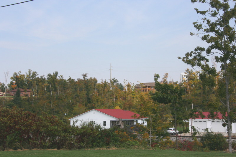
debris once lay, new houses and commercial buildings have sprouted. The school is in full sway, with new buildings in place of the ones flattened by the storm. The only evidence I could see that Henryville is a tornado town–and the clue is noticeable, chiseled into the landscape–is a swath of shattered trees where the wind blasted the hillside east of the school. That memento left by the town’s dark visitor is not soon expunged.

On Tuesday the 30th, I made a side trip through Henryville on my way down to Clarksville, just north of the Ohio River from Louisville, Kentucky. I and my friend and long-time chase partner, Bill Oosterbaan, had been asked to do an interview with Karga 7, a production house for The Weather Channel, for a show spotlighting the Henryville tornado. A couple months ago, Nichole, a producer with Karga 7, contacted me to inquire about using my footage of the tornado, which Bill and I had caught at its formative and maturing stages north of Palmyra, Indiana. I directed her to my video broker, Kendra Reed of KDR Media, and Kendra negotiated agreements for Bill and me, and  now here I was, heading down I-65 toward Clarksville’s Clarion Hotel, where the interview was to be held.

I felt both pleased and nervous at the prospect of being featured on national media. I’m a low-key kind of guy, and while, as a professional wordsmith, I can communicate colorfully and descriptively when I need to, I’m not by nature a showcase personality. So I wasn’t sure what kind of interview material I’d make. Writing allows me to edit my words till they reflect my thoughts to my own satisfaction, but an interview doesn’t afford that luxury. I hoped to shed a realistic and positive light on storm chasing and chasers, neither of which I think the public understands very well; and I wanted to give a strong message for people to take personal responsibility for their own safety and that of their loved ones by paying close attention to severe weather forecasts and warnings and not depend on sirens.*

Nichole, her two camera persons, and the guy who greeted us at the door seemed like great people. They were professional, courteous, and enjoyable to work with. The actual interview lasted at least an hour and a half, and I think Bill and I did a good job answering the questions, playing off of and supplementing each other’s responses. In a couple instances, our answers differed. For instance, Nichole asked, “Did you know when you first saw it that this was a killer tornado?” I said no. We had caught the funnel at its inception and stayed with it through early maturity, and I felt comfortable saying it was a violent and potentially lethal tornado; however, “killer tornado” isn’t about storm strength but verified human impact, something quite different. All tornadoes have the potential to kill, but most don’t, and that includes the relatively few violent ones. Not until later would I learn of this storm’s heartbreaking toll on New Pekin, Henryville, and Marysville.

Bill said yes, but he had processed the question differently from me. He does business frequently in nearby Louisville and knows the area. He was aware of towns to the northeast that the tornado might impact, and he knew it could cross an interstate highway. Bill evidently felt comfortable with calling the tornado a killer at the onset, based on its violence. It boils down to a matter of how each of us interpreted the question. I think he and I would agree that neither of us knew what the storm was going to do, but we did know what it could do if it hit a community, and we very much hoped that wouldn’t happen.

Between Bill and me, I think we did a good job of communicating two messages: (1) the tension storm chasers experience between their passion for storms as the magnificent forces of nature they are versus the concern we feel for those who lie in harm’s way; and (2) the excellence and limitations of severe weather warnings, and the need for people to be proactive in safeguarding themselves against violent weather.  I hope those messages will come across clearly in our part of the TWC episode. We did our best, and from here, our content rests in the hands of the film editors. I look forward to seeing how it all turns out. Interview aside, the footage Bill and I got of the tornado was spectacular and affords a unique perspective of the tornado. I chalk that up to good forecasting, serendipity, and Bill’s knowledge of the area.

On March 2, 2012, Bill and I had been chasing together for sixteen years, beginning well before technology improved the odds of seeing tornadoes. We had logged thousands of miles, busted many a time, gradually improved our forecasting skills, seen some amazing storms, and had a blast overall. The thing that kept us going was, and remains, sheer love for the storms, not money or media attention. But it’s nice to think that a little of both has finally come our way. Many thanks to Kendra Reed for her invaluable role in negotiating with Karga 7. Kendra, you are the absolute best!

The show will air this coming spring, probably sometime in April.

__________

* Civil defense sirens are the least dependable of warnings. When tornado victims say they “had no warning,” what they often mean is that the sirens weren’t sounded. I’ll reiterate here what I said in the interview: don’t count on sirens. They may or may not sound, depending on the judgment of your local civil defense; and if they do sound, you might not hear them for various reasons. Sirens are of limited effectiveness, and to rely on them as your primary warning is to live in the last century and jeopardize your safety. Today’s warning system harnesses everything from local television to mobile phones to social media and more, and while it’s still possible for the occasional rogue tornado to slip in under the radar, the big storm systems such as the one on March 2, 2012, are invariably well-forecast and well-warned.

Winter Solstice 2013: Tornadoes (or Not) in Dixie Alley and Ice Storms North and West

It has finally arrived: Winter. Astronomical winter, that is. Meteorological winter has already been with us for three weeks, beginning December 1, and in my book, that is the more climatologically accurate date. Particularly this year. For the first time since 2009, we in Michigan have been experiencing a good, old-fashioned Great Lakes winter. Here in Caledonia, the snowfall has exceeded a foot, and Lisa, who arrived here from Missouri five years ago hating winter and now loves it, dotes on it, rejoices in it, has been having a high good time during her two daily walks, equipped with brand-new winter hiking boots and a warm, warm, waaarm and dry, dry, dry waterproof down coat.

I am not so enthusiastic about all this white stuff as Lis is. My interaction with winter consists largely of sitting indoors at my work station, gazing out through the sliding door, watching the finches argue at the feeders and the woodpeckers whack away at the suet, and watching snowflakes pirouette gracefully out of the sky, and thinking, “Can we get this over with?”

Yes we can, in a few more months. Because today at last we tip the scale, and from here on, daylight will be on the upswing.

Two weeks ago, on December 8, the sun set in my town at 5:08 p.m. EST, just as it had been doing for the preceding four days, hovering within the eight-minutes-past-the-hour range but setting just a few seconds earlier each day. The 8th was the earliest sunset date of the year. From then on, sunset time would arrive incrementally later. For the next five days, through December 13, it would remain at 5:08, but instead of losing seconds, now it would begin to add them back until, on December 9, the sun would set at 5:09.

The converse does not, however, hold true for the day’s first light. The sun will continue to rise later and later until January 3 of the new year. By then, the sun will have been rising at 8:14 a.m. for five days until finally, on that date, the sunrise will, like the sunset, hit its own tipping point. From thenceforth, losing a few seconds each day, it will begin its slow march toward an earlier and earlier hour. On January 8, it will rise at 8:13 a.m.; on January 12, at 8:12; on the 14th, at 8:11; and so it will go, until on the 31st, it will rise at 7:59. By then, the sun will be rising approximately a minute earlier each day, and we will have gained fifteen minutes of sunrise time.

Why, then,  is today, winter solstice, so special? Because today marks our shortest period of overall daylight, the narrowest space between sunrise and sunset. From tomorrow on, even though the sun will continue to rise later and later for a while, the sunset time will begin to outpace it and the gap between sunrise and sunset will broaden–slowly at first, then with increasing swiftness. By the end of December, we Grand Rapidians will have gained 41 seconds of daylight for a total of 9 hours, 14 minutes, and 16 seconds on December 31. By March 18, we’ll be adding daylight at 2 minutes and 15 second per day, at which point we’ll have maxed out and the gains, while still continuing up to the summer solstice, will become gradually less.

You now know more about the winter solstice than you probably ever cared to. What makes this particular solstice even more interesting is the weather that’s shaping up for it, which shows promise of making it a headliner with tornadoes in the deep South and ice storms to the north and west.

Day 1 Winter Solstice 1630 Mod Risk 2013Here is the 1630Z convective outlook for today, depicting a moderate risk stretching from western Kentucky and Tennessee southwestward into Louisiana, with a 15 percent hatched area for tornadoes.

Given the brevity of daylight, I find this situation interesting but not particularly appealing.  A look at forecast soundings suggests a crapload of rain, low CAPE, and high helicity, all driven by massive shear and Jackson MS 19Z RAP_Skew-Trocketing along through formidable terrain. A lot of chasers are out there, and I’m sure that if I lived in that area, I’d be among them, but looking at the Shreveport radar, I don’t feel like I’m missing out on something. I got my fill of chasing fast-moving, rain-wrapped storms last November in optimal territory, and considering how that chase turned out, I think I’ll be a lot more selective about such scenarios in the future. That said, I wish those who are out there good success.

And safety. Drive carefully, mates and matesses. No storm is worth jeopardizing your safety over.

As for me, I’m sitting well on the other side of the cold front, and freezing rain is in the forecast, though my local WFO has backed off on it in their forecast discussion. Lots of areas in the Midwest are getting hit with icy conditions, making for hazardous driving, power outages, downed tree limbs, and the like.

The day grows later, and so far, glancing at the radar down south, I just don’t see anything very exciting–just a messy-looking MCS with one cell south of Memphis showing a hint of rotation. Only wind reports so far, and I suspect that’s how this thing will continue to play out. Tough for anyone who drove down there hoping for more; good for denizens of the region.

And so enters the winter of 2013–14. Time to wrap up this post and get on with the rest of this afternoon.

Intercepting the March 2, 2012, Palmyra-Henryville-Marysville, Indiana, Tornado

Now, while my video from Friday’s chase is uploading to YouTube, is a good time for me to write my account of how things transpired down in southern Indiana.

The phrase “historic event” rarely describes something good when applied to severe weather. March 2 may qualify as a historic event. The current NOAA tally of tornado reports stands at 117; the final number, while likely smaller once storm surveys have been completed and multiple reports of identical storms have been consolidated, may still set Friday’s outbreak apart as the most prolific ever for the month of March. Whether or not that proves true, Friday was unquestionably a horrible tornado day that affected a lot of communities from southern Indiana and Ohio southward.

The Storm Prediction Center did an excellent job of keeping track of the developing system, highlighting a broad swath of the eastern CONUS for a light risk in the Day Three Convective Outlooks and upgrading the area on Day Two to a moderate risk. On Day One, the first high risk of 2012 was issued for a four-state region that took in southern Indiana and southwest Ohio, most of Kentucky, and north-central Tennessee–a bullseye in the middle of a larger moderate risk that cut slightly farther north and east and swept across much of Mississippi and Alabama as well as northwestern Georgia.

The SPC and NWS offices weren’t the only ones keeping vigilance. Storm chasers across the country were watching the unfolding scenario, among them being my good friend Bill Oosterbaan and me. Here are the February 29 00Z NAM model sounding and hodograph for March 2, forecast hour 21Z, at Louisville, Kentucky. (Click on the images to enlarge them.) With MLCAPE over 1,800 J/kg, 0-6 km bulk shear of 70 knots, and 1 km storm-relative helicity at 245 m2/s2, the right stuff seemed to be coming together. By the time the storms actually started firing, those figures were probably conservative, particularly the low-level helicity, which I recall being more in the order of 400 m2/s2 and up. Simply put, the region was going to offer a volatile combination of moderate instability overlaid by a >50-knot low-level jet, with a 100-plus-knot mid-level jet core ripping in.

I had my eyes set on southeastern Indiana. The problem with that area is, it’s lousy chase terrain along the Ohio River, and it doesn’t improve southward. If there was an ace-in-the-hole, it was Bill’s knowledge of the territory, gleaned from his many business trips to Louisville.

We hit the road at 7:15 that morning, stopping for half an hour in Elkhart so Bill could meet with a client and then continuing southward toward Louisville. Bill was of a mind to head into Kentucky, where the EHIs and CAPE were higher; I was inclined to stay farther north, closer to the jet max, the warm front, and, presumably, stronger helicity. But either choice seemed likely to furnish storms, and since Bill was driving, has good instincts, and knows and likes western Kentucky, I was okay with targeting the heart of the high risk rather than its northern edge.

But that plan changed as we drew near to Louisville. By then, storms were already firing, and one cell to our southwest began to take on a classic supercellular appearance. Bill was still for heading into Kentucky at that point, but after awhile, a second cell matured out ahead of the first one. We now had two beautiful, classic supercells to our southwest, both displaying strong rotation. It was a case of the old adage, “A bird in the hand is worth two in the bush”–except in this case, there were two birds, back to back. And I-64 would give us a clear shot at both of them.

So west we went, and into chase mode. At the Corydon exit, we caught SR 135 north, headed for an intercept with the first supercell. The two radar captures show the base reflectivity and SRV shortly after we began heading up the state road.

A few miles south of Palmyra, we got our first glimpse of a wall cloud maybe four miles distant. That’s all there was at that point, and the hilly, forested terrain afforded less-than-optimal viewing. Within a minute or two, we emerged into an open area just in time to see a funnel descend from the cloud. Tornado!

The sirens were sounding in Palmyra, providing an eldritch auditory backdrop to the ropy funnel writhing in the distance as we drove through town. The tornado went through various permutations before expanding into a condensation cone revolving like a great auger above the treeline. It was travelling fast–a good 60 miles an hour, at a guess. As we sped toward it, the condensation hosed its way fully to the ground and the tornado began to broaden. It crossed the road about a half-mile ahead of us, continuing to intensify into what appeared to be a violent-class tornado with auxiliary vortices wrapping around it helically.

Shortly after, Bill and I came upon the damage path. We pulled into a side road lined with snapped trees, amid which a house stood, somehow untouched except for a number of peeled shingles. The tornado loomed over the forest beyond, an immense, smoky white column wrapping around itself, rampaging northeastward toward its fateful encounters with Henryville and Marysville.

The time was just a few minutes before 3:00 eastern time. While I prepared and sent a report to Spotter Network, Bill turned around and headed back south. We had another storm to think about, and it was closing in rapidly. It wouldn’t do to get caught in its way.

Back in Palmyra, we headed west and soon came in sight of another wall cloud. This storm also reportedly went tornadic, but it never produced during the short time that we tracked with it. We lost it north of Palmyra; given the topography, the roads, and the storm speed, there was no question of chasing it.

From that point, we headed south across the river into Kentucky to try our hand at other storms, but we saw no more tornadoes, nor, for that matter, much in the way of any serious weather. Not that there weren’t plenty more tornado-warned storms; we just couldn’t intercept them, and after giving it our best shot, we turned around and headed for home.

Lest I forget: my worst moment of the chase came when I couldn’t locate my video of the tornado in my camera’s playback files. It seemed unfathomable that I could have horribly botched my chance to finally capture decent tornado footage with my first-ever hi-def camera. After being miserably sidelined during last year’s record-breaking tornado season, the thought that I had somehow failed to record this day’s incredible intercept just sickened me. Fortunately, there were no sharp objects readily available; and better yet, the following morning I discovered that I had simply failed to scroll up properly in the playback mode. All my video was there, and it was spectacular. Here it is:

My excitement over the video was offset by reports of just how much devastation this tornado caused eighteen miles northeast of where it crossed the road in front of Bill and me. Henryville, obliterated. Marysville, gone. Eleven lives lost in the course of that monster’s fifty-two-mile jaunt. And similar scenarios duplicated in other communities across the South and East. The death toll for the March 2 outbreak presently stands at around forty.

In the face of a mild winter and an early spring, Friday was the inauguration for what may be yet another very active severe weather season east of the Mississippi. We can only hope that there will be no repeats of last year’s wholesale horrors. May God be with those have lost loved ones and property in Friday’s tornadoes.

Here Comes the Summer Pattern

Sumer is icumen in,
Loudly sing, cuckoo!
Grows the seed and blows the mead,
And springs the wood anew;
Sing, cuckoo!
Ewe bleats harshly after lamb,
Cows after calves make moo;
Bullock stamps and deer champs,
Now shrilly sing, cuckoo!
Cuckoo, cuckoo
Wild bird are you;
Be never still, cuckoo!

Right. It looks like we’re about to have our hands full, what with bleating ewes, cows making moo, and so on. There are, however, some things that the old folk song fails to mention. The polar jet lifting north, for instance. Weakening mid-level winds. Temperatures at 700 mb heating up, with the 12 degree centigrade threshold expanding across the southern and central plains and ushering in the era of capping. I don’t know why the ancient songwriter didn’t address these matters. They’re as much a part of sumer–that is to say, summer–as stamping bullocks.

Here in Caledonia, yesterday was hot and today promises to be even hotter, around 95 degrees, before a cold front blows through tonight and brings relief. After that, we look to be in for a bout of unsettled weather. I’ll take it, even though it may inconvenience at least one outdoor gig I’ll be playing this weekend.

The summer weather pattern is on the way, putting the damper on storm chasing in the southern and central plains. Considering how devastatingly active this spring has been, that’s probably a good thing. I doubt that the people in towns such as Joplin, Missouri, will lament this season’s passing. As for those who chased storms in Dixie Alley and the southern plains–and there were more chasers than ever this year–you certainly got your fill of action, and some of you saw far more than you cared to. There are some amazing stories that have come out of the storm chasing community, and my hat is off to those of you who stepped in to help in tornado-stricken areas.

This was the worst of all seasons to be sidelined due to financial constraints, but that’s how it has been with me and with others who have taken a hit in the pocketbook from this rotten economy. I’m frankly happy to see the crest of storm season 2011 passing; I much prefer to occupy my mind with more productive thoughts than fretting over what I’m missing.

In any event, the playground is shifting northward. It’s not there quite yet, but it’s on the way. Troughs that had been digging deep into the southern plains are now beginning to ripple across the northern tier and Canada, and lately, mesoscale convective systems have been cropping up regularly in the SPC discussions. Those are the specialty of the state where I live.

If there’s any advantage to living in the Great Lakes, it’s that we’re close enough to the summer jet stream that it can still dip down out of Canada into our neck of the woods. And while northwest flow isn’t exactly your classic chase scenario, it can deliver some occasional surprises. Illinois in particular has gotten some whopping summer tornadoes–and for those of you who don’t chase east of the Mississippi, I don’t mind telling you that central and northern Illinois is fabulous chase territory. Also, closer to home, even garden variety arcus clouds are sublime to watch sweeping in at the Lake Michigan shoreline.

For better or worse, sumer is icumen in and storm season is winding down. Most people aren’t sorry for the change. But most people don’t view storms the way that storm chasers do. I guess we’re a bit cuckoo.

Tornado Video Resembles Paul Huffman’s Famous Twin-Funnels Photo from the 1965 Palm Sunday Outbreak

On April 11, 1965, Elkhart Truth photographer Paul Huffman parked his vehicle by the side of US 33 northwest of Goshen, Indiana, and began snapping pictures of a tornado passing within a half-mile of him. One of those images, captured as the twister was in the process of devastating the Midway Trailer Park, became what is probably the most famous tornado photograph ever taken, and the icon of the nation’s second deadliest large-scale tornado outbreak. Paul’s image of twin funnels straddling the highway is instantly recognizable to anyone familiar with the 1965 Palm Sunday Outbreak.

Like countless weather weenies, I’ve been fascinated with Paul’s photo. As a storm chaser, I’m familiar with multiple-vortex tornadoes. Today meteorologists understand that they’re fairly common. Yet multiple vortices take all shapes, sizes, and behaviors, and I’ve always been on the lookout for something that seemed to approximate what was probably happening in Paul’s photograph (really his series of photographs depicting a single funnel undergoing vortex breakdown into the infamous “twins”).

Just a few minutes ago, I came across a new YouTube video that is the closest I’ve ever seen to what the Midway tornado–and very likely the one that hit Dunlap 45 minutes later–may have been like. I don’t normally feature YouTube videos in this blog because I hate discovering that the video I had included in a post a year ago no longer exists. But besides being truly impressive, this clip is just too strikingly reminiscent of Paul’s historic photo to pass by.

The video was shot just yesterday in southeast Oklahoma by storm chasers Marc Austin, Robert McIntyre, and Gabe Garfield. At 1:08 into their clip, you can see two large twin funnels embedded in the parent circulation. It’s a spectacular display, and my hat is off to these guys for catching the storm of the day. Tragically, the tornado killed at least one person and caused significant damage in the towns of Tushka and Atoka.

The system that produced the Tushka/Atoka tornado and a number of others yesterday is moving east today. Mississippi and Alabama lie within a moderate risk, with a good possibility of strong to violent tornadoes. The storms are ongoing this morning as I write, and a whole day lies ahead of them for moisture and instability to build across Dixie Alley. It’s not a pleasant prospect. Let’s hope that the damage will be minimal and no more lives will be lost.

A Stormy New Years Eve in the South?

slp-gfs-123110slp-nam-123110Could be. If the GFS is right, the chance of severe weather in the Gulf states looks good. The NAM too, having leaned in with its 12Z run, also points to the possibility of a New Years Eve episode down in Dixie Alley, though it wants to nudge the ingredients slightly to the west and north.

sfc-tds_mlcape-gfs-123110sfc-tds_mlcape-nam-123110So far the SPC appears to believe that severe weather is likely in the South on Friday, but while they’ve mentioned the T-word, tornadoes, they’ve been reluctant to say anything emphatically. Of course, we’re still four days out, and hitherto the forecast models evidently haven’t jibed (I haven’t followed the trends till now). But between this 500mb-heights-gfs-123110500mb-heights-nam-123110morning’s GFS and NAM, it looks like a pretty decent intrusion of moisture will lick inland from east Texas eastward to Florida, with 500 J/kg MLCAPE overlaid by ample shear as a large mid-level trough digs into the nation’s midsection. From the looks of things, Louisiana, Arkansas, and Mississippi could be in the crosshairs, and eventually, 500mb-winds-gfs-123110500mb-winds-nam-123110perhaps Alabama and the Florida panhandle.

Here are some GFS and NAM models for you to compare. Left-click on the thumbnails to enlarge them. I’ve used the model runs available to me at this writing on F5 Data–6Z for 6km-shear-gfs-1231106km-shear-nam-123110GFS and 12Z for NAM. The valid times should read 18Z, not 17Z.

.


Yazoo City Tornado Number Two: A Stormy Night in Mississippi

Last night’s tornado in Yazoo City, Mississippi, thankfully appears to have been not nearly as bad as its monstrous EF-4 predecessor back in April, but it was bad enough. It was one in a round of tornadoes that trampled across the South yesterday afternoon on into the night. Fed by ample moisture and energized by bulk shear exceeding 60 kts and 1km helicity exceeding 300, supercells had no problem firing up and dropping tornadoes. At the time of this post, seven tornado reports have been logged for Dixie Alley–one in Louisiana and six in Mississippi. (A tornado was also reported in northwest Missouri, but that’s far removed from the southern storms and was a separate situation.)

I watched my GR2AE radar screen in disbelief last night, shortly before 9 p.m. EST, as strong circulation progressed from the southwest toward Yazoo City. “No way,” I thought. “No freeking way.” How could the same small town get clobbered by a tornado twice in the same year? It wasn’t going to happen. It just couldn’t. But it did.

At 8:18 CST a tornado warning was issued–a continuation of a previous warning–which contained the following statement: AT 816 PM CST…LOCAL LAW ENFORCEMENT REPORTED DAMAGE FROM A TORNADO JUST PASSING THROUGH THE CITY. THIS TORNADO WAS LOCATED 6 MILES SOUTH OF EDEN MOVING NORTHEAST AT 50 MPH. At that point I could see the potent SRV couplet moving right through what appeared to be the south edge of the town. According to reports this tornado crossed the path of the April storm, like a letter X. Fortunately, it appears to have been nowhere nearly as large or violent, and a scan or two later showed the mesocyclone weakening considerably as it left the city. Here is the string of reports from the National Weather Service at Jackson:

0800 PM     TORNADO          5 SW YAZOO CITY         32.81N 90.47W
11/29/2010                   YAZOO              MS   AMATEUR RADIO

            3-4 MILE LONG PATH OF DAMAGE ALONG EAGLE BEND ROAD.
            LIKELY TORNADO DAMAGE. UPDATED...VEHICLE
            OVERTURNED...STRUCTURAL DAMAGE...SHOP DESTROYED. NEAR THE
            NORTHERN INTERSECTION OF EAGLE BEND ROAD AND HWY 3.

0808 PM     TORNADO          YAZOO CITY              32.86N 90.41W
11/29/2010                   YAZOO              MS   AMATEUR RADIO

            DAMAGE TO THE COURTHOUSE ROOF IN DOWNTOWN AND A LARGE
            TREE DOWN NEXT TO THE COURTHOUSE. WIDESPREAD DEBRIS IN
            THE AREA.

0810 PM     TORNADO          YAZOO CITY              32.86N 90.41W
11/29/2010                   YAZOO              MS   AMATEUR RADIO

            ADDITIONAL STRUCURAL DAMAGE REPORTED IN YAZOO CITY WITH
            NUMEROUS LARGE OAK TREES SNAPPED AND UPROOTED. POWER
            LINES ALSO REPORTED DOWN ALONG CENTER RIDGE ROAD.

0810 PM     TORNADO          YAZOO CITY              32.86N 90.41W
11/29/2010                   YAZOO              MS   EMERGENCY MNGR

            MAJOR STRUCTURAL DAMAGE REPORTED TO AT LEAST 18
            BUSINESSES...MINOR DAMAGE TO AT LEAST 3 WOODEN FRAME
            HOUSES. ENTIRE FACADE OF ONE DOWTWON BUILDING HAD ALL
            WINDOWS BLOWN OUT. 30 PERCENT OF YAZOO CITY REMAINS
            WITHOUT POWER.

0810 PM     TORNADO          YAZOO CITY              32.86N 90.41W
11/29/2010                   YAZOO              MS   AMATEUR RADIO

            POWER LINES...TREES...AND WIDESPREAD POWER OUTAGES ARE
            REPORTED WITHIN YAZOO CITY. WILL UPDATE FURTHER WITH
            ADDITIONAL INFORMATION.
.

While Yazoo City stands out by virtue of having gotten hit twice this year, other communities also sustained damage. The show began in the afternoon and evidently continued through the night, because when I woke up this morning and fired up my computer, I saw a tornado warning in Alabama. Tornado watches are currently in effect for the southeast, and the SPC shows a slight risk extending north as far as southeastern Pennsylvania, with a 10 percent hatched area reaching from South Carolina into Virginia.

The images on this page are GR2AE volume scans of the next supercell southwest of the Yazoo City storm, heading on a trajectory just west and north of Port Gibson. Click on the images to enlarge them. The time was 0232Z, or just a couple minutes after 8:30 CST. The topmost frame shows a hook and correlated structure above it, with the suggestion of a pretty healthy BWER. The bottom frame depicts vigorous rotation.

Dixie Alley Severe Update: Yazoo City

Unbelievable. Yazoo City, Mississippi, which sustained a massive and deadly EF-4 tornado back on April 24 of this year, got hit by another tornado just a couple hours ago. A tornado warning issued at 8:18 CST reads as follows:

AT 816 PM CST…LOCAL LAW ENFORCEMENT REPORTED DAMAGE FROM A TORNADO
JUST PASSING THROUGH THE CITY. THIS TORNADO WAS LOCATED 6 MILES
SOUTH OF EDEN MOVING NORTHEAST AT 50 MPH.

A line of tornadic supercells continue to rake across Mississippi. As I write, at 9:19 CST, the most robust circulation is west of Raymond; however, weaker circulation is passing just to the north of Port Gibson. Oops, new scan in, and that circulation appears to have intensified. And there are other tornado-warned storms in progress as well.

This will be a nasty night for Dixie Alley dwellers. I’ll have more to write tomorrow, along with a couple volume scans to share from GR2AE. Let’s hope and pray that no fatalities result from this round of severe weather. Night time storms are killers.

Dixie Alley Lights Up

Severe storms have been pushing through Dixie Alley this afternoon and evening, fed by dewpoints in the mid 60s to lower 70s and propped by bulk shear in the 60-70kt range. The action has been largely in Louisiana, where tornado warnings have been ongoing for several hours and tornado damage has been reported northwest of Atlanta.

Typical of southeastern storms, these ones look pretty HP-ish, real drenchers. They’ve waned in intensity from earlier, but they’re still dangerous storms, and one of them  in East Carroll County is presently tornado-warned.

Here’s a GR2AE volume scan from the Shreveport radar depicting storm-relative velocity at 2107Z. Click on the image to enlarge it. You can see a pronounced couplet, indicating strong base-level rotation. I believe this was in fact the storm responsible for the tornado report, although two others in the same region displayed potent mesocyclones. More tornado reports may turn up from that part of Louisiana before the night is through.

El Nino and a Delayed 2010 Storm Season

Back in December I wrote a post speculating how El Nino might affect the moisture fetch from the Gulf of Mexico. I wrote as a non-expert, which is always my position regarding weather related stuff, but it appears that my concern about the influence of cooler sea surface temperatures on return flow actually held water.

Tornado season normally begins ramping up in Dixie Alley in February, solidifies in March, peaks in April, then begins to decline in May as the action moves west and north toward traditional Tornado Alley.

Last year the tornado total for February, 2009, was 43. It consisted of six tornado days, two of which were outbreaks of 12 and 21 tornadoes.

This year, the tally for February was a statistically unprecedented zero. That’s no, nada, zippo tornadoes at all last month. Instead, the South experienced record-breaking cold weather, with snow in virtually all of the southern states and a series of brutal winter storms lashing Oklahoma, Texas, and parts of Dixie Alley.

Now we’re into March, and the snow seems to finally be behind us. As I sit here writing, I can look out the sliding doors of my apartment at a beautiful day with temperatures climbing into the mid forties. I’ll take that with a smile, along with the warming trend that’s in store for this coming week here in West Michigan. But at the same time, sampling buoys across the Gulf of Mexico, I see water temperatures in the low to mid fifties and some really horrible dewpoints. It looks a lot like what the ENSO sea surface temperature table has predicted, namely, cooler-than-average temperatures.

We’re presently looking at  systems moving through the Plains that might be tornado breeders if they weren’t starved for moisture. It’s hard to get excited about dewpoints that barely scrape into the low to mid fifties pretty much everywhere except waaay down in southern Texas and Louisiana.

no images were found

Okay, it’s only March. What’s a bit scary is to think that the Gulf may not be up to snuff till as late as May. Click on this image of the Climate Prediction Center”s ENSO sea surface temperature anomaly forecast, updated March 1, and you’ll see what I’m talking about. The first two tables are the ones you want to pay attention to. That blue in the Gulf of Mexico doesn’t look too promising.

I hope I’m wrong, and it could be that I am. A quick glance at water temperatures west of the Florida peninsula shows some temps into the seventies well out into the Gulf, so maybe things will pick up more quickly than the map suggests. The ENSO update does indicate that El Nino is weakening:

•A majority of the models indicate that the Niño-3.4 temperature departures will gradually decrease at least into the summer.

•The models are split with the majority indicating ENSO-neutral conditions by May-July 2010 and persisting into the Fall. Several models also suggest the potential of continued El Niño conditions or the development of La Niña conditions during the Fall.

–Page 27, March 1, 2010, CPC-NCEP ENSO Update

That’s a good sign, kind of. The last part leaves us hanging, but as always, time will tell.

More immediately, I wonder, as I did three months ago, whether we won’t see a delayed storm season. I think, I hope, that when it does finally arrive, it will be a stellar one.  There’s reason to be hopeful, considering the ample ground moisture available for evapotranspiration throughout Tornado Alley, including areas that languished last year under a severe drought. No such problem this year. I hear some chasers talking about West Texas, and I’ll bet they’re right. Once the Gulf finally does set up shop, whether sooner or later, I expect to be making some trips out west. See y’all at the edge of the meso.