Low-Topped Supercell Images from Last Wednesday

Last Wednesday, May 11, in northwest Kansas was a bust chase as far as tornadoes were concerned. But the prairie sky offers compensations that are blue-ribbon prizes in their own right if you’ve got an eye for beauty.

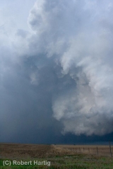
Here are some shots of a couple of low-topped supercells taken in the Atwood/Oberlin area. These storms dumped some marble-sized hail and exhibited visible, though not strong, rotation. They were lovely to behold, sculptures of moisture shaped by the wind and lit by the light of the waning evening. Atmospheric dramas such as these are the true panorama of the Great Plains. Like a run-on sentence, the treeless landscape stretches off into limitless sameness, leaving the sky to provide punctuation, energy, and color.
March 28 Tornadoes in the Southeast

An outbreak of severe thunderstorms spun off a series of damaging tornadoes in the Southeast earlier this evening. The SPC’s preliminary count shows eight tornado reports, seven in North Carolina and one in Florida.

Two trailer parks in Davidson County, North Carolina, sustained damage, with multiple injuries, and for Guilford County came this report:

GUILFORD COUNTY EMERGENCY MANAGER CONFIRMED 20 STURDY HOMES DAMAGED NORTH OF HIGH POINT. (RAH)

In all, this evening has been an active one weatherwise, with low-topped supercells rumbling across the hills and flatlands from Florida on up to Virginia. As I write, three tornado warnings are in effect, though at this point they’re all Doppler warned and I think the storms are done producing for the night.

Of course I’ve done my share of armchair chasing. Here are a couple radar grabs of two North Carolina supercells. The first image, taken at 9:30, shows base reflectivity, and the second, captured 24 minutes earlier at 9:06, shows storm relative velocity. Don’t ask me to explain the lag time, because I can’t–I didn’t realize so much time had elapsed between image grabs until I looked at the file details a while later. No biggie, though–this isn’t a research paper, and you get a good idea of the progression of the storms.

They weren’t big storms, but they sure packed a punch. For me, this spring thus far has been a demonstration of how you don’t need 60s dewpoints and

much CAPE at all in order to get tornadoes. Cold mid-level temps conspiring with  massive shear and hulking 1 km helicities can do a lot with dewpoints 55 degrees and even lower. Today’s 6 km shear has been in the order of 90 knots in places, with low-level helicities exceeding 400. That’ll get the job done, and evidently it did this evening.

Sea surface temperatures in the Gulf of Mexico remain cooler than normal, but with the GFS consistently wanting to bring in decent moisture–finally–into the Plains, and now with the NAM painting a similar picture, what could prove to be a very active tornado season may at last be stirring to life. Tonight may prove to have been a warning shot fired across the bow. Storm chasers, got your Rain-X ready?