That’s right, fellow storm chasers, you read my headline right. I’m about to raise a few eyebrows by tossing out the possibility that backing winds–or, more precisely, what we normally consider to be backing winds as depicted on forecast maps–aren’t always vital to tornadic storms.* This isn’t speculation as much as it is observation. Over the years I’ve seen a number of tornadic events develop in the midst of southwest surface flow, enough to think that the absence of southeasterly winds on the forecast map isn’t always a deal breaker.
What is indispensable are the conditions that southeasterly boundary layer winds tend to create. I’m thinking of ample deep-layer moisture and sufficient low-level storm-relative helicity. Those are what count. If they are present, it doesn’t much matter which way the wind blows from our perspective. The atmosphere sees things differently and doesn’t care what we think. It just does what it does.
Let me quickly say, I’m a huge fan of southeasterly surface winds. I love to see them on forecast maps. And I’m aware that winds can back locally in ways that the maps don’t portray. What I’m really talking about here is forecasting using the tools we have to work with, which continue to improve. Until last year, for instance, I’d never heard of the HRRR. It’s a marvel. But generally speaking, in contemplating the prospects for a chase day we’re still dealing with pretty broad brush strokes, and the farther we live from Tornado Alley, the better we need to be at determining how those strokes will play out.
A Regional Thing?
In writing about forecasting matters, I still feel very much like a neophyte who may be getting into matters that are over my head. I’m no Jon Davies or Chuck Doswell. I’m not even a meteorology student. But you know the old saying about fools, angels, and where they tread.
My sense of things is that as we move east of the Mississippi, southeasterly surface winds become less important for moisture fetch–and, I might add, southwesterly 850s aren’t such a terrible thing. Why? For one thing, moisture sources in the Gulf of Mexico no longer lie to the southeast, but to the south, and even to the southwest in eastern parts of the CONUS. Also important, the desert southwest isn’t nearly so proximate an influence. Thus, H85 winds that would kill a setup with dry air advection in Oklahoma can carry moisture up into Illinois and Indiana. Moreover, that moisture is apt to follow a curvy path–one that can, for instance, take it first northwest from the Gulf, then north, then northeast up into the Great Lakes.
All that to say that the trajectory of moisture transport can look different in different parts of the country.
As for helicity, does it really matter whether you’ve got southeasterly, or even southerly, surface winds as long as 0-1km SRH is in the neighborhood of 150 or greater? Years of reading convective outlooks leads me to believe that the SPC doesn’t think so. What I’m saying here is no doubt old hat to them. But it may seem a bit out of the box to at least some storm chasers, particularly those whose thinking has been conditioned by setups in the southern and central Great Plains. The whole concept of storm-relative helicity suggests that the term backing is, well, relative, a matter of how winds relate to a storm as it moves, not to the compass. That’s why right-turners produce. A few days ago in Pennsylvania, overall storm motion was consistent with unidirectional winds from the west; yet a rogue supercell deviated to the right and spun up a tornado near Greensburg.
A Few Examples
Seeing is believing. Here are a few maps that show surface conditions around the time of tornado incidents east of the Mississippi.
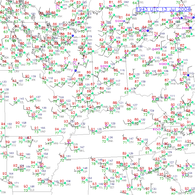 The July 12, 2004, Roanoke, Illinois, tornado is an example of a classic northwest flow event. Rated F4, the tornado was large, long-lived, and not the first violent tornado to occur in northwest flow during the warm season in Illinois. Four years earlier, the disastrous 1990 Plainfield F5 was fueled by massive CAPE amid northwest flow.
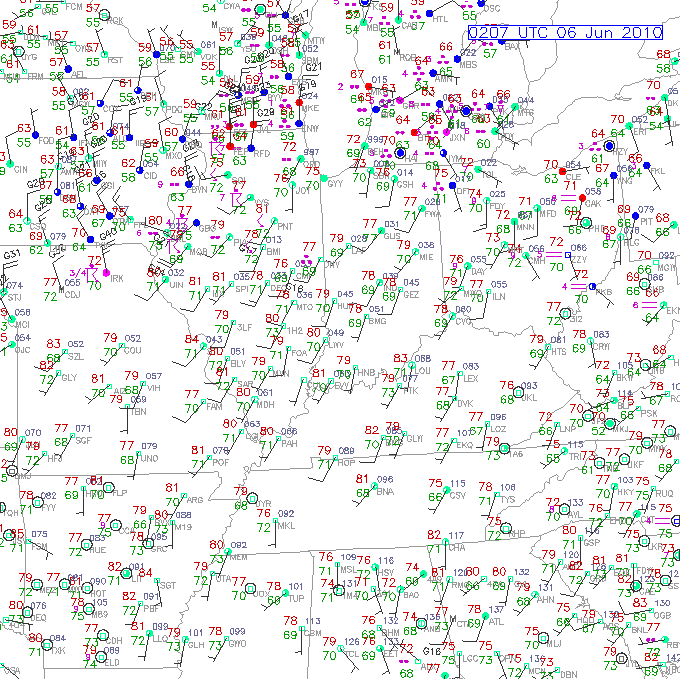
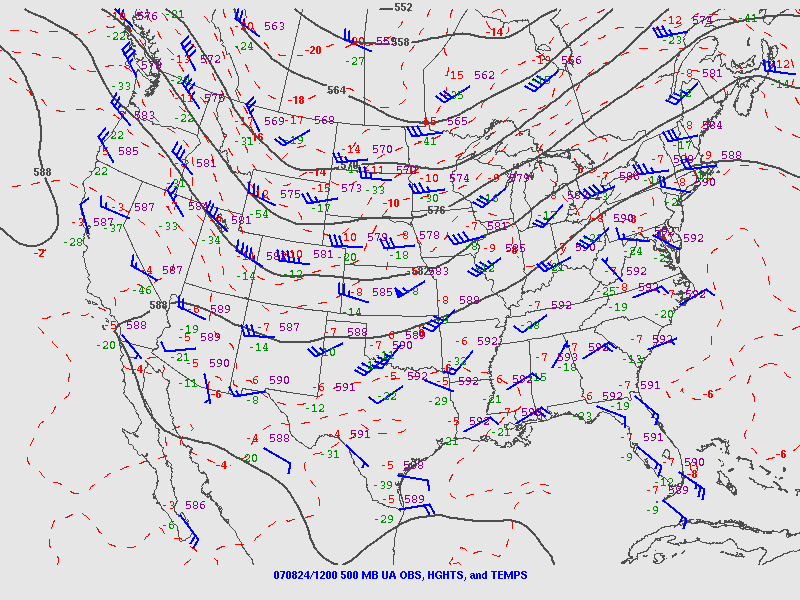
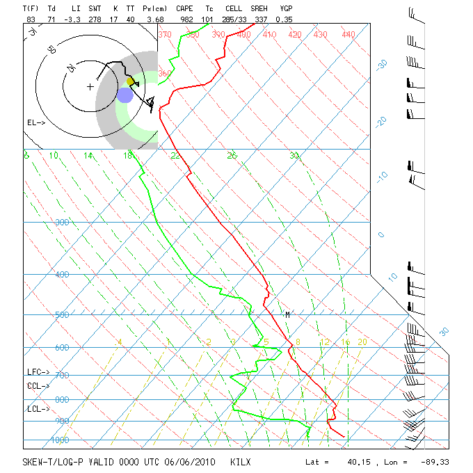 The June 5, 2010, central Illinois outbreak was a sort of quasi northwest flow situation. Mid-level winds were predominantly westerly with just a slight northerly component to them. The surface and 850 winds were unquestionably veered. Besides the surface map, I’ve also included the ILX 00z sounding, which preceded tornadogenesis by roughly an hour.
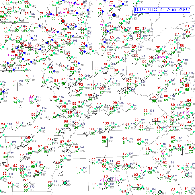
 Finally, the Potterville, Michigan, tornado practically dropped in my lap, but I ignored what the radar was showing me because I was too dumb to believe my eyes even when the dynamics were plainly visible in the clouds right over my head. This was not a northwest flow event; in fact, as you can see by comparing the surface and 500mb maps, it looked to be unidirectional from the southwest, with directional shear increasing as the trough moved east and mid-level winds became more westerly.
You can find plenty more examples besides these, I’m sure. My point is simply this: Don’t be too quick to write off a synoptic setup because of veered surface winds in the forecast, particularly east of the Mississippi. If moisture is in place and there’s reason to hope for adequate SRH, then it can pay to take a deeper look. Things could pop. They’ve done so before and they’ll do so again.
_______________
* ADDENDUM, March 3, 2013: The term “backing” has a couple of different applications. I used it a bit naively in the title and copy to mean southeasterly surface winds, which is the meaning by which I first came to understand the word. That becomes apparent quickly in the article, but it bears explaining. If I were writing this post today, I’d simply say “southeasterly” and erase any uncertainty of what I meant.


Bob,
Great write-up. You’ve really hit it right on the dot for when it comes to the wind direction as a regional thing. For me, backing surface winds are a significant indicator of a deepening, stationary low pressure system and the significance of them is something relative to the location as well as relative to the storm. In the Southern Plains if surface winds are too badly veered, you often get a delay in the moisture return and mixing problems. So surface wind direction isn’t a thing for shear, it’s more a thing that greatly causes adjustment of thermodynamic parameters. Anytime I see veered surface winds in the Southern Plains, I can easily deduce that the winds above must continue to veer with height, and will cause downslope warming from air on the lee side of the Rockies. This air will mix with the moist layer beneath it and kill your nice dewpoints. You don’t get this problem when you’re away from the mountains. Backed surface winds is a rule of thumb that has it’s source in Southern Plains weather (that’s where severe weather forecasting was developed), but as you’ve deduced, it doesn’t hold true elsewhere.
You’re also right about the fact that supercells work in the storm relative framework. My mesoscale class is just starting on supercells and the first thing the professor mentioned is that we have to consider winds relative to the storm.
Bob,
Sometimes surface winds back, sometimes they do not, in response to approaching or developing storms. In many cases in the Ohio Valley, backing winds kill storms because that hints a change of air mass. BUT IT DOES INDICATE THE PRESENCE OF A BOUNDARY!!! Many of the BIG outbreaks in the Ohio Valley are with south winds at the surface with southwest at 850mb, 5000 ft AGL. Veering winds in the lowest 1 km are the meaning of life when it comes to tornadogensis in the Ohio Valley.
You are correct in your assessment of Environmental Storm Relative Helicity. First of all, you need SRH 0-3km to be over 150 m2/s2 in order to even fulfill one parameter for supercells to develop. Northwest flow cases satisfy this right away, if you have favorable precedent conditions in the environment. Again, a boundary being present enhances SRH and thus horizontal streamwise vorticity in the vicinity of the developing supercell. Then, if the SRH in the 0-1km is over 150 m2/s2, then the potential for weak tornadoes is possible. Values of 250 m2/s2 are much better for long-lived tornadoes providing you have plenty of instability present.
Nowhere did you discuss other factors needed- low level jet of 35 kt or better; 500 mb jet of 50 kt or better; 250 mb jet 70 kt or better. How about the key ingredient – the presence of a well-mixed layer protruding into the backend of the favorable air mass!
The presence of an east-west boundary (warm front, convective boundary-old or new, moisture boundary) HAS to be presence for the backing of winds to be meaningful. southeast winds can bring in recycled air from a surface high moving off to the east away from the area, but if those southeast winds are in the vicinity of the boundary, it just may be the difference between a surface-based storm vs. a slightly elevated storm, but yet still be tornado productive.
Look at the case of the April 20, 2004 Utica, IL tornado. Here a NEGATIVELY tilted trough resulting in backing surface winds with very steep lapse rates (indicating the well mixed layer and mixed layer CAPE of 1500 J/kg). This was a perfect example where violent tornadoes developed in southeast winds just north of the boundary. And, as shown by Paul Sirvatka at the College of Dupage, a pooling of low 50 dew points just along the boundary!
Backing winds ARE important in that they indicate the presence of a boundary, a boundary that can enhance horizontal streamwise vorticity that does end of tilting into the updraft of a developing supercell.
Dan, thanks for taking the time and thought to lean in and share your expert insights. I wish I had a lot more opportunity to bounce my thoughts and questions around with weather professionals, particularly guys like you who have worked at the SPC.
Your critique is well-taken, but I think you may have missed my point in writing the article. In a nutshell, I was simply saying that not all tornadic setups live or die with southeasterly or even southerly surface winds per se. Backed versus veered surface winds are just one aspect of a whole array of ingredients to consider, and your response does a good job of bringing out that very point. I just didn’t see a need to cover all the bases with a storm chasing readership that is for the most part already acquainted with them. Rather, I wanted to talk about a single aspect of tornado forecasting that has fooled me as a homegrown forecaster in the past (and probably still will in the future, though I’ll be more aware of it), share some general thoughts, and furnish some examples to back up my point.
As I’d mentioned in the article, I love southeasterly surface winds. I’m a junkie for them! So I’m certainly not out to trash well-founded conventional wisdom that I base my own forecasts on.
But I’ve had to learn forecasting on my own, something that is true of a great many chasers, and for me that learning curve has been piecemeal, and remains so. One mistake I’ve made has been my failure to sometimes grasp bigger synoptic pictures, and also smaller mesoscale possibilities, due to my making snap judgments based on forecast surface conditions. “Oh, the surface winds are veered. No point in bothering with that system!” While that assessment is by-and-large realistic, sometimes it has led me to throw out the baby with the bathwater. I overlooked other factors such as northwest flow, the existence of boundaries, whether deep moisture was in place and would remain in place, how surface winds might respond to storms–all things I’m still learning about–because I’d already made up my mind based on a single ingredient. I wasn’t adequately reckoning with the four-dimensional nature of the atmosphere, and I was overlooking regional influences on weather. I doubt I’m the only chaser who has ever been fooled this way, so I thought I’d toss out a little food for thought. All three of the examples I’ve cited are ones which, based on the forecast surface winds alone, would have made me think no tornadoes would occur where they did. Yet all three had other factors at work that resulted in tornadoes. Talking about this stuff is part of the process of my filling in my own gaps in knowledge!
Posts such as this are the observations and musings of an amateur—in the best sense of the word—as he thrashes with the complexities of severe weather forecasting. I may see something that bears closer inspection, but I may not see it with the clarity and depth that formal schooling and years of professional experience provide. I just know I’ve identified something worth looking at, and so I toss it out there for consideration as best I’m able, welcoming addenda, input, and critique. I think there’s value in doing so, and I’m pleased when people more knowledgeable than I follow up with their comments because it broadens the picture. If other chasers can benefit from such a post and from whatever discussion may ensue, then that’s the best I could possibly hope for!
PS Hmmm…I think this reply is longer than my original post!
I’m glad you enjoyed the article, Greg, and I appreciate your sharing your own insights. In writing on this topic, I’ve run the risk of being misinterpreted as saying that southeasterly winds aren’t important at all. I think that most of the time they’re very important, and they’re one of the cardinal things I look for in contemplating a chase scenario. But I think they’re important because of the dynamics those winds tend to set up as they interact with other factors, and if those factors deviate enough, then they may create conditions favorable for tornado formation amid a more veered surface flow–veered, that is, relative to the compass, not to the storm or to upper-level winds. Northwest flow is a classic case in point.
I’m well aware that we’re dealing with exceptions to the rule. But those exceptions do occur. Often they may not be something I’d want to chase, but then again, I also don’t want to blow off a day like June 5, 2010, simply because the ambient surface winds are southwesterly!
Bob, very good response and it is appreciated. I have been thinking further of your original post and wanted to compliment you on one aspect. You mentioned that of the atmospheric response to the winds – due to the supercell. This is a very astute point! Many people keep in mind just what is supposed to be going on in the environment, but do not thing of the environment affected BY THE STORM.
When meteorologists learn about supercell structure, papers by Browning, Fankhauser, Klemp and Weisman, all learn about supercells in steady-state, i.e., an unchanging strom environment, which is unrealistic.
You are spot on that one needs to think relative to the storm. When a person first learns about weather, when they are in 4th grade, you learn that in order to find the low pressure system, you stand where the winds are at your back and the low will be on your left direction. Now think that same way in the mesoscale relative to the storm.
Now, while standing in this position observe your surroundings – what direction are low clouds coming from? which way is the higher clouds, or anvil heading? etc. I recall being in northwest Norman as the Oklahoma City tornado was approaching on May 3, 1999. While surface winds were 150-170 degrees, low clods were streaming FROM THE EAST at 60 mph! That told me where the tornado was and where I needed to be for safety. At that point, there was thinking that our neighborhood was in the path of the storm.
But, as video from Tim Marshall shows as he chased the storm, the satellite tornado that developed on the southeast side of the meso near the tornado, converged into the tornado, it forced the storm to turn slightly left as it crossed the Canadian River southwest of southwest Oklahoma City, and continued on its northeast tracked causing massive F5 damage.
Further fruit for thought.
Dan, I want to thank you again for sharing your comments. I can’t emphasize enough how much I welcome thought-provoking input from informed sources. I appreciate the value you’ve taken the time to add! And that’s some fascinating stuff on the OKC tornado, both from a meteorological standpoint and a personal one. It had to be pretty unnerving for you, knowing what you know, to contemplate the prospect of what at that point seemed to be heading your way. Sixty mph inflow stinger? Scary.
Back in 2006, my buddy Bill and I hooked up with what has been called the Six-State Supercell in Columbia, Missouri. I remember blasting east down I-70 with the meso just to our north as the storm lifted to the east-northeast. At one point, a section of cloud appeared to be sitting stationary. Then I realized the apparent motionlessness was an illusion–the cloud was keeping pace with us, and we were doing around 80 mph!