
Look at that pinhole in the reflectivity knob! I was even better defined in the ensuing scan, after which the rotation became more diffuse and the storm began to weaken. Prior to this, a few dedicated and fortunate chasers videotaped a nice

Look at that pinhole in the reflectivity knob! I was even better defined in the ensuing scan, after which the rotation became more diffuse and the storm began to weaken. Prior to this, a few dedicated and fortunate chasers videotaped a nice
Monday and Tuesday this week were the storm chase from hell. It you’re looking for a nice, upbeat post about chasing, you’d best skip this one. My feelings about my fiasco in Nebraska may have mellowed down enough for me not to unleash a full-bore rant anymore, but I’ve still got enough gunpowder left to blow off a few firecrackers. That’s the result when impediment piles upon impediment and frustration upon frustration.
With my sights Sunday night fixed on western Iowa and eastern Nebraska the next evening, I set my alarm clock for 4:30 a.m. and hit the sack. I was awakened by early morning light filtering through the window. Light? I glanced at the clock. It said 6:30. My alarm hadn’t sounded and I was running late.
Nuts. But okay, no problem. After a fast shower, I kissed Lisa good-bye, threw my gear into the car, and hit the road. I still had plenty of time to make

Thirty miles down the road in Zeeland I made a delightful discovery: I had left my debit card in my other pants pocket. This was the beginning of woes. Self-possessed person that I am, I responded calmly and maturely by protruding my eyeballs, depressurizing my feelings constructively using the special vocabulary that I reserve for just such occasions, and, a cat of nine tails not being handy, by rapidly banging my fist on the steering wheel in lieu of self-flagellation.
Retrieving my debit card meant losing over an hour. I now was pushing the envelope, but I could still make eastern Nebraska by late afternoon. This being probably my last crack at a good setup in a record storm season during which I’ve been miserably sidelined, I was determined to try. So off I went again.
I wasn’t far south of Holland, Michigan, when the disquiet in my stomach became a bubbling, and the bubbling escalated into the kind of tar-pit-like seething that tells you a quick trip to a bathroom will be required in the near future. Between southern Michigan and east of Chicago, I made three pit stops. Another 45 minutes, literally gone down the toilet before I finally popped some Immodium and put an end to the rumblings.
By the time I drew near to Omaha, the show was underway. A tornadic supercell was moving up out of Kansas into Nebraska toward the center of the surface low. My friend and long-time chase partner Bill Oosterbaan, who had called me as we both were initially approaching Zeeland and just as my debit card fiasco was commencing, was now far ahead of me and positioning himself for the next storm down. That storm went spectacularly tornadic and Bill got some great footage, probably the best he’s gotten so far.
But there was no way I could make it that far west in time to catch tornadoes. My show was clearly going to be the pair of cells to my southwest that were heading toward Lincoln. They were my one chance. But they were south of the warm front, and while surface winds were southeasterly, the storms were moving north-northeast. The low-level helicity required for tornadoes was lacking. My hope was that as the storms headed north they would tap into increasingly backed winds.
But all they did was backbuild and congeal into a nasty squall line. My hopes were still up as I approached Lincoln; however, as I finally drew near to the northernmost cell along US 77 west of Roca, I could see that I was screwed. The cells had congealed into a pile of linear junk. I had driven over 750 miles to chase a shelf cloud, and it wasn’t even a particularly photogenic shelf cloud. True, it had the local media in Omaha screaming about 75 mph winds and flash flooding, but I’ve seen plenty better right here in Michigan. Linear mess-oscale convective systems are our state storm.
No point in prolonging the pain. I started heading home, my idea being to get far enough east that I’d have time to chew on the system’s leftovers back in Michigan the next day. Bill had business in Iowa and was overnighting at the Hilton in Marshalltown, so I bunked with him there. He’d gotten four tornadoes in Polk County, and we reviewed his footage. Very nice stuff! He’d gotten close enough to a large tornado to capture the roar. Here’s his YouTube clip.
Sigh. So near and yet so far. An arcus cloud isn’t much of a compensation prize compared to a tornado. Of course there was still tomorrow back home. A warm front looked poised to drape right across Grand Rapids with SBCAPE in the order of 4,500 J/kg–an optimal setup for Michigan, except that the models consistently depicted the 500 mb jet hanging back just to the west in northern Illinois and Wisconsin.
Bill and I in fact hooked up again the next day after his business meeting and briefly discussed chasing the low in Wisconsin. But that area is some of the worst chase terrain imaginable, so we scrapped the idea and went our ways.
Somewhere around Davenport, out of idle curiosity, I checked out the SPC’s mesoanalysis graphics and noticed that the mid-level energy appeared to be nudging eastward toward Michigan. Hmmm…maybe there might be a bit of a show after all. I gave Kurt Hulst a call. He had hung back in town and was planning to chase today, not expecting much but thinking that the big CAPE could compensate somewhat for poor upper air support. I agreed, particularly now that it looked like 500 mb and higher winds might reach the threshold for storm organization.
Later VAD wind profiles at GRR showed nice veering with height along with 30 kt winds at 18,000 feet. Not a setup to die for, but it might just work. And it did. A beautiful supercell fired up along the warm front, and Kurt was on it in a heartbeat. He got in some nice chasing on several storms, witnessed rotating wall clouds and a funnel extending halfway down, and did some call-ins for WOOD TV8. Good work, Kurt!
As for me, I got delayed by a traffic bottleneck in Joliet, Illinois, and attempting to find a detour proved to be a huge, time-consuming mistake. I finally arrived in Michigan in time to chase storms, but not the ones on the warm front. Once again I had to settle for what I could get as I belted east down I-94 and punched through the line near Marshall. By then the mid-level winds had backed off and I was left with the usual, disorganized Michigan crap-ola. There was a lot of that, though. The warm sector was remarkably juicy, and more storms kept popping up behind the main line.
Heading back through Battle Creek, I parked in a lot across from the old Kellogg Museum and watched a couple of cells south and west of me detonate their munitions. I’ll say this: The lightning this day was intense, lots of brilliant, high-voltage positive strokes, many of which struck close by. It was an impressive, beautiful, and exciting pyrotechnic display.
But now that it’s all behind me, my tornado tally for this year remains zero. Between Monday and Tuesday I drove over 1,600 miles and blew through around $200 worth of gas to see nothing that I couldn’t have seen by simply sitting in my apartment and looking out the window. It’s frankly a bit humiliating, considering what a benchmark season this has been for storm chasers. Family comes first, though, and tight finances in a rotten economy have been a potent regulator. Sometimes all a body can do is choose his attitude. I confess that mine wasn’t all that great these last couple of days, but I talk with the Lord about such things. It’s the best I can do: put my feelings before Him honestly, then do what I can to adopt a more positive spirit and move on.
Still…it sure would be nice to see a tornado yet this year. Just one. I don’t think that’s too much to hope for. Sigh. Maybe this fall.
The formidable system that ground out large, violent tornadoes in Kansas, Oklahoma, and Texas on Tuesday will move east on Wednesday to bring another round of severe weather to southeast

Based on Tuesday morning’s NAM run, I’d been eyeballing Effingham, Illinois, as a preliminary target for trolling the I-70 corridor. The sounding for that area looked mighty pretty, as you can plainly see.

Tomorrow morning’s data will tell all. Meanwhile, it’s time for me to get my ugly-rest. I am so excited about the prospect of finally getting out and feeling the moisture, watching cumulus towers erupt and organize into glowering supercells, and hopefully videotaping some tornadoes out on the flat, wide-open Illinois prairie! A good night’s sleep and then I’m off in the morning.


At last, the setup I’ve been waiting for–one that warrants dipping into my tight finances in order to make the 1,000-mile drive to the Southern Plains. To date, this present system has been a miserable disconnect between upper-level support and instability, with a nasty cap clamping down on the whole shebang. Last night it managed to cough up a solitary tornado in South Dakota. That was it. I’m not sure what today holds, but I haven’t seen anything to excite me about it or tomorrow.
But Wednesday…ah, now we’re talking! The SPC places a large section of the Great Plains under a slight risk, and their discussions have been fairly bullish about the potential for a wide-scale event. At first I couldn’t see why. My mistake–I was looking at the NAM, which with straight southerly H5 winds has not provided the best PR for Wednesday’s setup. But once I glommed the GFS, I got a whole ‘nother picture, one which the SREF and Euro corroborated.
That was last night. I haven’t looked at today’s SREF, and the new ECMWF gives me a slight pause as its now somewhat negative tilt has slightly backed the mid-levels from the previous run. But only slightly. The H5 winds still have a nice southwesterly flow, and taking the three models together, everything you could ask for is lining up beautifully for tornadoes in the plains.

Other places in the region also look good, though. Farther south in Texas, Wichita Falls shows potential. Helicity isn’t as persuasive as Enid, but the CAPE tops 3,000 J/kg and there’s less

I haven’t been as drawn to Kansas so far, but with the triple point perched there, storms are bound to fire up just fine in the Sunflower State. The details will work themselves out between now and Wednesday evening. Significantly, the tyrannical cap of the previous few days no longer appears to be an issue.
The bottom line is–it’s time to head West! This evening I’m taking off for the plains with my long-time chase buddy Bill. At last! Time to sample what the dryline has to offer, and–now that I’m equipped with a great HD camcorder–finally get some quality footage of a tornado or two.
There’s no place like the Great Plains! YeeeeHAW!!!!!
With sunshine and cold temperatures forecast through Monday and beyond here in West Michigan, I’d say we’re in the process of becoming nicely ridged. The GFS and NAM agree on a little trough digging into the southern plains on Saturday, with a surface low just southeast of the trough axis fetching moisture up into Dixie Alley. Shear is ample, as you’d expect this time of year, so maybe the South will see some organized storms. But up here in the north, none of that matters. Chilly and uneventful are the words for us this next week or so.
So it’s nice to know that chasers got in a little early play Tuesday in Iowa. The Storm Prediction Center shows 18 tornado reports, including the photogenic Creston tornado: a beautiful, sunlit tube that a number of chasers captured on camera and video. That had to have been a sight to see, and I congratulate those of you who witnessed it.
The big surprise came a day later, though, yesterday in Greensburg. No, not Greensburg, Kansas; Greensburg, Pennsylvania, 25 miles southeast of Pittsburgh. Who would have expected a tornado out there in March in hill country? True, the SPC had issued a moderate risk for the east, but that was considerably farther south, and the affected area was teetering on the very edge of a light risk. The bulk shear certainly was capable of producing supercells, but I figured they’d just be hailers. I had written off the setup as a straight-line wind event.
Yet a supercell drifting across the jumbled terrain of southwest Pennsylvania exhibited a pronounced mesocyclone that culminated in the Greensburg tornado–this in an environment where temperature and moisture that seemed inadequate to begin with dropped rapidly over the course of just a few miles. Lapse rates had to have been steep in order to sustain the storm in those conditions.
As near as I can judge, the Pennsylvania supercell appeared to drift along some kind of warm frontal boundary, with just enough moisture and heat to sustain it and enough helicity to produce a tornado. VAD wind profiles at KPBZ were straight from the west at all levels; farther east-northeast, however, at KCXX, backing surface winds veered rapidly with height, providing decent low-level torque.
But that was, I believe, in colder air. It strikes me as a pretty delicate balance that sustained the Pennsylvania supercell. Greensburg is located in the Allegheny Plateau in the foothills of the Appalachian Mountains, so perhaps the terrain may have influenced local boundary-layer winds enough to produce the Greensburg tornado. I can only speculate. The Plateau overall is mountainous, but when I look at photos of Greensburg, the town appears to be situated in a fairly level area. What the case is five miles southwest in Hempfield Township, where tornado damage was reported along Route 136, may be a different matter. I don’t know the area. However, the highway map shows curvy roads consistent with a rugged landscape.
It’s fun to think about when there’s no other weather to contemplate, which right now there isn’t. But it’s on the way. It’s spring, the sun is higher, the Gulf is setting up shop, and Storm Season 2011 is moving in.
ADDENDUM: Having looked at a few videos of the tornado in Hempfield since I made this post, I’m inclined to think that terrain wasn’t a factor. Looks like the right ingredients just came together on the mesoscale level. Interesting storm!
 Here’s something you don’t see very often on the morning of December 31. (Click on thumbnail to enlarge it.) It’s 10 a.m. and for the last half-hour I’ve been watching lightning flicker outside my window and listening to thunder rumble.
But that’s nothing compared to what’s going on farther south. Already three fatalities have been reported in Arkansas, and tornado warned storms are scraping across the region. As I write, there are two strong SRV couplets in Missouri southwest of Waynesville and west of Houston–potent little supercells fueled by dewpoints in the upper 50s. It’s 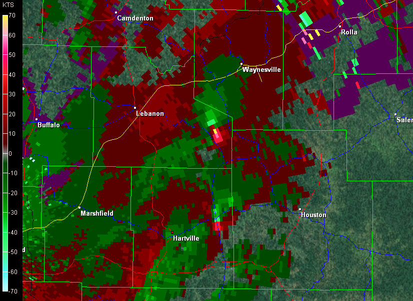 certainly not what you’d expect this time of year, but this event has been shaping up for several days.
I’ve got a gig this evening–it’s New Years, after all–so my extent of involvement in this weather scenario will be to watch it unfold to the south of me on radar and enjoy its occasional outbursts of lightning and thunder here in my own Michigan backyard. Later today Louisiana and Mississippi could get hammered, but right now the action is farther north, where buckets of shear are organizing the storms and driving them along at 50 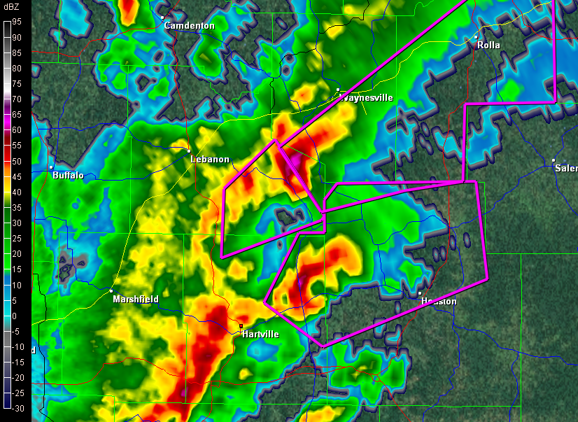 miles an hour. If that little bugger south of Waynesville holds together, Rolla is going to get whacked within the next half hour.
Enough writing. I’m going to upload some radar images for this post and then watch this event unfold.
Now here’s something you don’ see very often on November 22 in the Great Lakes: supercells cruising across northern Illinois. I’d be very happy to be on either the one northwest of Toulon or the one northwest of Princeton. The storms are extending along the cold front northeast on into Wisconsin.
Whoops! The one down by Toulon is now tornado-warned. Imagine that! Here are some radar grabs. Click on them to enlarge.
And with that, I’m signing off.


Yet I came close to missing it. The forecast models were all over the place with the synoptic setup. The GFS indicated formidable capping. The NAM offered more hope, but convective inhibition was still clearly a huge consideration. And the upper-level winds looked borderline.
But if the right ingredients did come together and the cap broke–and it looked like there was a chance that this could happen–then a whopping 5,000 j/kg CAPE would be at hand to produce explosive convection.
So Mike Kovalchick and I pulled the trigger. The potential was worth the risk of traveling 1,000 miles for a blue sky bust. My friends and long-time chase partners Bill and Tom Oosterbaan had also been tipping on the fence with this setup, but they, like Mike and me, decided it was worth a roll of the dice. So off went the four of us in Mike’s Subaru Outback, headed for South Dakota.
We stopped in Murdo to gas up and bumped into a few other chasers, including Ben Holcomb, Adam Lucio, Danny Neal, and Scott Bennett. We would run into these guys again later, but, as I’ve already mentioned, that’s for another post.


With horror, we realized that we were about to watch a large, violent tornado strike a community. It looked like it was maybe half a mile to our north* and, taking a right turn, was heading slightly southeast toward the road ahead of us according to the GR3 SKIT marker. We pulled aside to avoid getting eaten. Other than that, all we could do was pray for the people in Bowdle.
There was nothing pretty about this tornado anymore. It was a smudge of darkness boiling beneath a low and intensely agitated cloud base. The wind was powerful, and as we sat there, a bunch of large plastic conduits came tumbling across the field in our direction. Fortunately, these missed us, and the tornado changed its course, just sideswiping the north end of Bowdle and taking out some large, high-tension electrical towers.
Had the tornado not shifted, I am as certain as can be that we’d have witnessed another Greensburg, Kansas/Parkersburg, Iowa scenario. Thankfully, considering what might have been, this violent wedge had relatively minimal impact. The damage it did cause has subsequently earned it an EF-4 rating.


The tornado morphed into a truncated tube with multiple vortices circling around its base like braids in a rope, then into a needle. It finally reconsolidated into another classic, Kansas-style funnel, as photogenic as you could ever hope for, before

I’ve presented the photos of this last tornado sequentially to give you a sense of its life cycle. But as visually stunning as it was, the structure of its parent

I’ll leave you with one last photograph of the entire scene, with the tornado spinning like a dervish in the distance beneath the storm. What followed next is a story in itself, one that I’ll never forget.
Don’t worry, I won’t leave you hanging. Look for Part 3, coming soon to a blog site near you.

——————–
* November 26, 2011: I’ve done some minor editing to this post to correct a couple of factual errors. In doing so, I’ve chosen to let my statement stand about my perception of the distance. Records indicate that the tornado in fact passed a mile north of Bowdle. It certainly looked closer than that to me when it was approaching the town–in fact, I thought it was starting to turn right at one point–but my lack of experience with such a large and powerful tornado, the lowness of the cloud base, the intensity of being in so violent a storm environment, and the excited commentary within the vehicle probably all influenced my perception of the distance involved.
The eastern Great Lakes looks to be once again under the gun for severe weather, with a setup that looks reminiscent of last week’s, albeit with some variations. The low is weaker but there’s juicier moisture, helicities may integrate a little better with instability, and it seems to me that the 500 mb jet is better positioned. Once again, though, surface winds veer rapidly south of the warm front, so while the mechanism for another batch of supercells is in place, the tornado potential is less certain. The SPC convective outlook shows a 5% tornado risk. That seems about right, though maybe part of the area will get upgraded this afternoon.
After looking at the morning NAM and RUC, I once again like the area south of Toledo. Bowling Green was my initial target last week, and I’d pick it again this week if I wanted to drive that far. If I chase storms at all today, I may just wind up dropping south down 131 toward the warm front, depending.
By the way, I haven’t posted a thing about Monday’s tornado fest in Oklahoma and I probably should. I wasn’t there to experience it, but my buddies Kurt Hulst and Bill Oosterbaan teamed up for it, and Ben Holcomb made it down there as well, and everyone scored. Bill tells me that he and Kurt saw seven confirmed tornadoes.
Me, I watched the outbreak unfold on the radar and ate my heart out. It really was a heck of a thing to observe. The SRVs were jaw-dropping, and I saw one low-level Delta velocity of 177 knots. Those storms were the real deal, and a huge contingent of chasers was on them. Among the highlights was the Wakita, OK, multi-vortex that a number of chasers captured on video. The clips I’ve seen show what looks like a basketful of snakes dancing.
Unfortunately, five people died in the storms. If there’s anything positive that can be said about the loss of life, it’s that the paths of the storms through mostly rural areas no doubt kept casualties lower than they could have been. One supercell dropped tornadoes in Oklahoma City, and all it takes is one. But that’s better than multiple population centers getting hit by storms the intensity of Monday’s storms.
I don’t know why so many storm chasers decided to chase in northern Missouri this last Monday. I could have told folks it had “cap bust” written all over it–didn’t fool me for a minute, as you can see by reading my post written the day before.
Ahem…right, so I got snookered too. The GFS was spot on about the cap, and the NAM way underforecast it. As a result, Missouri chasers wound up sitting under relentlessly empty skies waiting for convection to fire. It finally did in northeast Kansas–after dark. Storms ignited along a boundary (the warm front? ) and a couple went supercellular and even tornado-warned for a heartbeat before the cap re-exerted itself and squenched them.
The real action, ironically, took place in central Illinois and Indiana, well east of where most folks–including me–had expected. Supercells cut a swath along the warm front through Terre Haute, Indianopolis, and parts east and southeast into Kentucky, and a number of purple boxes lit up the radar screen. Nevertheless, SPC storm reports list only one confirmed tornado that touched down near Hillsboro, Illinois, northeast of Saint Louis.
Them’s the breaks. I didn’t chase that day, and I’m glad that I didn’t because I’d almost certainly have gotten skunked in Missouri when I could have driven straight south down US 41 to Terre Haute, not even having to mess with Chicago traffic, and waltzed on into the sweet zone.
Ah, well. I chased today–if chasing is what you can call a guaranteed grunge fest–down toward a warm front by the Michigan border. The trip was my compensation prize for not heading out when it really counted these past few days. The SPC had outlooked a five percent tornado risk this afternoon, and supercells were making their way northeast across Illinois toward Indiana. I figured that if they held together, I might catch them, but not surprisingly, they mushed out.
That was okay. I was chasing blind, with no radar and few expectations other than the hope that I’d at least see some lightning. I did, and called it good. The main storm season is still on the way, and there’s no need to fret over spilled milk when the cow is just priming its udder. It won’t be long now.

