For the Birds

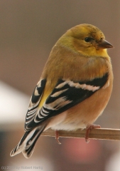
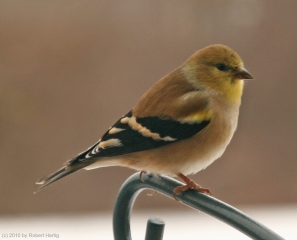
The little fellow you see here paused long enough for me to snap his photo, but his repose was fleeting. Inaction is a concept foreign to goldfinches when they’re in feeding mode, which is pretty much from sunrise to sunset. (Left click on photos to enlarge them.)

Just outside my sliding glass door, a blizzard of finches descends on my feeding station early in the morning, and the party continues throughout the day. Other wild birds join in the melee–chickadees, white-breasted and rosy-breasted nuthatches, tufted titmice, sparrows, and a male and female downy woodpecker. Occasionally a shy junco or two will put in a brief appearance, and a big bruiser of a bluejay flits in now and then, brashly announcing his presence with a cry that lets the whole neighborhood know he’s here, and whacks away at the suet with his wedge-like beak.

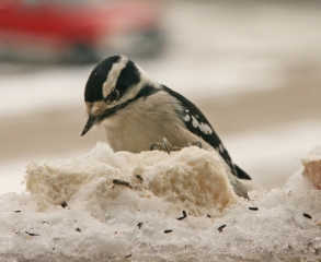
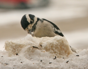
When killing frost signals the last gasp of the growing season, then, like a changing of the guard, the plants come in off my balcony and the bird feeding station goes out. Two tube feeders–one filled with wild bird mix, the other with black oil sunflower seed–hang from the station’s metal arms in company with a bag of thistle seed for the finches. This year, determined to attract a woodpecker or two if I could, I also hung out a mesh onion bag full of suet and slapped a couple more hunks out on the balustrade. It’s as a complete a smorgasbord as any bird could hope for, and the response has been supremely rewarding. It has included, I’m happy to say, the woodpeckers–a sprightly gentleman with a red bar across his head, and his consort, a perky little lady without the bar, each showing up when the other isn’t there and gorging with mighty singleness of purpose on the suet.

During the winter months, the feathery circus out there on the balcony reminds me that life goes on even when bitter winds blow. Today I tripoded my camera by the sliding door, intent on capturing a few images from the carnivalia. With so many birds thronging the feeding station, you’d be surprised at how difficult it can be to get a decent shot. These are not creatures who like to sit still, let alone pose for the camera. The bright-eyed goldfinch to your  left complied for about a second, long enough to look coy and unspeakably cute. It’s not for nothing that a bunch of these little guys and gals is called a “charm.”

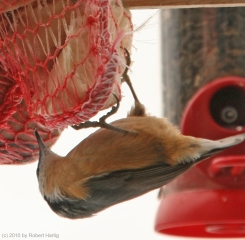
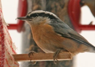
The woodpeckers and nuthatches were more demanding. I had to wait for them, and they had a way of showing up when I had walked away from the window. I did finally manage to catch them at an opportune time. The nuthatches are a favorite of mine, part comedian and part acrobat, with no apparent sense of up or down nor any regard for the law of gravity.

Talking about the weather has for me never been synonymous with shallow conversation. There is a time of year when I find few topics more fascinating. Unfortunately, winter isn’t

that time. Music, too, inexhaustible though it may be as a pursuit, has its limitations for me as a focus for blogging. In a word, I just don’t always have musical or weatherly stuff to write about, and I don’t like stretching too far for material. It’s a big world, filled with all kinds of interest and plenty of alternatives when subject matter gets thin. The birds are at the window day in and day out, chattering, flitting, quarreling, and consuming black oil sunflower seed with marvelous rapidity. They deserve a nod if not my outright gratitude. When snow cocoons the northwoods and whirls across the parking lot, they make me smile, and they’ll see me through till spring.

So this post is for the birds.

Or had you been thinking that all along?
Great Lakes Waterspout Season Is at Hand

Now is the time of year when waterspouts start putting in an appearance on the Great Lakes. I had largely forgotten about spouts until a few days ago when my friend and fellow weather weenie Mike Kovalchick mentioned them in an email. Bing! A light blinked on in my head: That’s right! Waterspouts!

I’ve never seen a waterspout. But then, until last year about this time with my buddy Kurt Hulst, I’d never made a point of going out after them. Kurt and I busted that day, but maybe this year I’ll get lucky, provided I increase my chances by taking more opportunities to chase spouts.

I have zero experience forecasting waterspouts. Thankfully, there’s a snappy little graph called the Waterspout Nomogram that simplifies the process. Developed by Wade Szilagyi of the Meteorological Service of Canada, the Waterspout Nomogram provides a quick visual aid for determining when certain critical parameters are in place for four different classifications of waterspout: tornadic, upper low, land breeze, and winter.

The tornadic variety is self-explanatory, and any storm chaser with some experience making his or her own forecasts should have a good feel for when that kind of waterspout is likely. Mike favors the 500 mb cold-core, closed low setup, which to my thinking may be a variant of the first in producing low-top supercells. The remaining two, land breeze and winter, seem to involve different dynamics. For all the waterspout categories, one of the constraints is that for spouts to occur, winds at 850 mbs have to be less than 40 knots, something I find particularly interesting in the case of supercell-based waterspouts.

In any event, I’m hoping that this year is my year to finally witness a spout or two. Michigan chasers and weather weenies, it’s time to pay attention to the marine forecasts. The “second season” can include action right along the lakeshore even when nothing’s popping anywhere else. Make sure you bring your shotgun just in case a waterspout gets too close for comfort (written with a wink and a grin).

An Independence Day Double-Header: Summer Weather Is Here

It’s July 4, Independence Day. Happy Birthday, America! For all the problems that face you, you’re still the best in so many, many ways. One of those ways, which may seem trite to anyone but a storm chaser, is your spring weather, which draws chasers like a powerful lodestone not only from the all over the country, but also from the four corners of the world.

no images were found

This has been an incredible spring stormwise, but its zenith appears to have finally passed for everywhere but the northern plains. And right now, even those don’t look particularly promising. That’s okay. I think that even the most hardcore chasers have gotten their fill this year and are pleased to set aside their laptops and break out their barbecue grills.

Now is the time for Great Lakes chasers to set their sights on the kind of weather our region specializes in, which is to say, pop-up thunderstorms and

no images were found

squall lines. The former are pretty and entertaining. The latter can be particularly dramatic when viewed from the eastern shore of Lake Michigan, sweeping in across the water like immense, dark frowns on the edge of a cold front. If you enjoy lightning photography, the lakeshore is a splendid place to get dramatic and unobstructed shots. Not that I can speak with great authority, since so far my own lightning pictures haven’t been all that spectacular. But that’s the fault of the photographer, not the storms.

The images on this page are from previous years. So far this year I’ve been occupied mainly with supercells and tornadoes, but I’m ready to make the shift to more garden variety storms, which may not pack the same adrenaline punch but lack for nothing in beauty and drama.

July 4th is a date that cold fronts seem to write into their planners. I’ve seen a good number of fireworks displays in West Michigan get trounced by a glowering arcus cloud moving in over the festivities. But tonight looks promising for Independence Day events. Storms are on the way, but they should hold off till well after the party’s over.  That means we’ll get two shows–the traditional pyrotechnics with all the boom, pop, and glittering, multicolored flowers filling the sky; and later, an electrical extravaganza, courtesy of a weak cold front. A Fourth of July double-header: what could be finer than that?

Rotten Nice Weather We’re Having

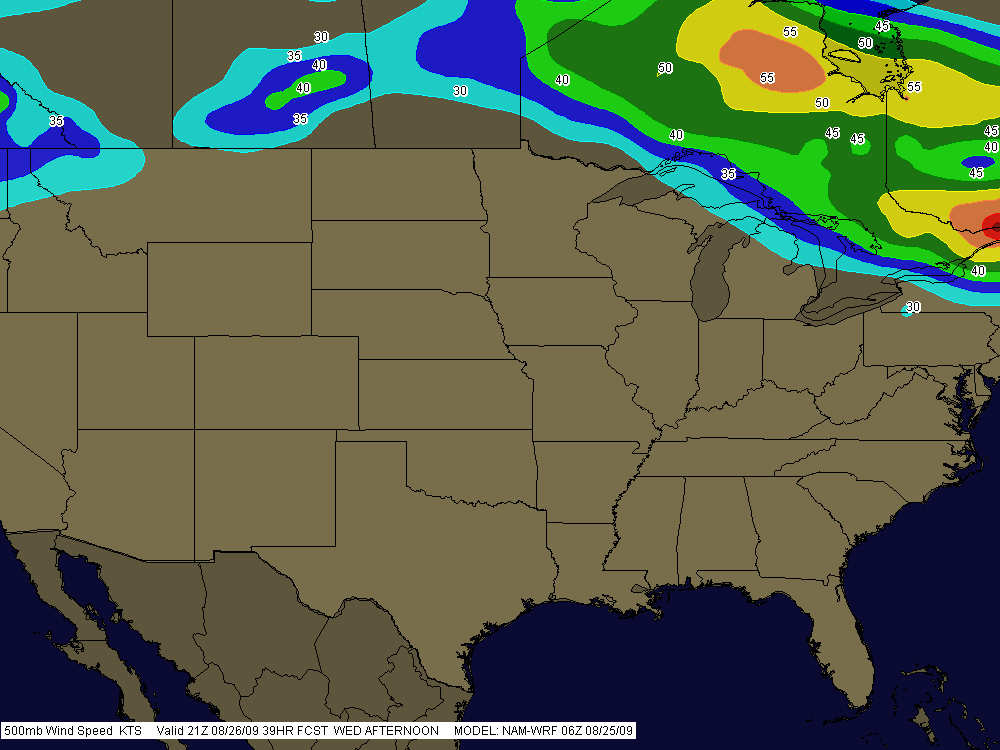
Boy, is it ever summer. The day has dawned a glorious blue, with nothing in the way of convective mayhem in sight anywhere in the nation. Nothing but pop-up thunderstorms on the menu for today here in Michigan, and the 500 mb jet is like a limbo bar raised high enough for most of the CONUS to squeeze under.

SummerPattern

It’s what you expect this time of year, and it’s what we’re getting. The SPC’s long-range outlook is calling for possible troughing by the weekend, so maybe we’ll see a round of severe weather yet. Who knows. But I’m not making any plans. This is August. Might as well be January so we can get winter over and done with, except…well, there’s still always hope this time of year, and the late season to look forward to.

So why am I writing when there’s nothing to write about? Just to wish you a nice day. Enjoy this beautiful weather we’re having here, cuss the luck.

The 2009 Storm Season: A Good One or a Bad One?

Reading a thread in Stormtrack, I came upon a comment in which the poster briefly griped about how the 2009 storm chasing season had been a lousy one for him. In the post that followed, another member mentioned that it wasn’t fair to blame the weather for one’s personal lack of scalps when the season itself had been pretty solid. The context was lighthearted, though I read enough pointedness to the second comment that it made me stop and think.

The first commenter never said there weren’t plenty of tornadoes; he just said that he’d had a lousy season. My own season hasn’t been that hot either. For the thousands of miles I’ve driven, I’ve only got one tornado to show for it–at least, one that I’m certain of. Sure, I’ve witnessed some beautiful structure and gotten beaned by some big hail in northwest Missouri, but this year has been nothing like 2008.

Am I blaming the weather? No. Those who were in a position to chase all the slight risk day in the Great Plains, from the southern plains to the Canadian border, had plenty of opportunities and did great. But me, I live in Michigan. Much as I’d like to be out there chasing slight risk days in Kansas, Nebraska, Colorado, and the Dakotas, logistically it’s just not feasible for me to do so. I’ve got a livelihood to earn, and gas and lodging cost money.

Add to that the fact that I made at least one poor judgment call that took me and my buddy south when we should have gone north, and I’ve had what amounts to a mediocre to poor storm chasing season. If I lived in the heart of Tornado Alley, I think I’d have enjoyed a much better one. But where I live, I have things to factor into my chase/don’t chase decisions that wouldn’t be as much of a concern if I lived in, say, Oklahoma City or Topeka, Kansas.

That’s not the weather’s fault. It’s just a matter of geography and personal circumstances. If I were to blame the weather for anything, it would be for putting in a substandard performance so far in the central Great Lakes, an area that never fares as well as the plains states to begin with. But of course, it’s pointless to blame the weather for anything, period. Weather isn’t an ethical entity–it just does what it does, and those of us who chase after it have to make our judgment calls the best we know how.

Living in Michigan, I’d be a fool to go after synoptic setups that I’d be an equal fool to pass up if I lived in Kansas instead. That’s the reality, at least for me, though I think I’m by no means alone.

So no, this hasn’t been a bad season for chase weather, not at all. But if you’re me, it hasn’t been a very good season for getting to much of the action.

Maybe the secondary season this fall will create a few more opportunities. I hope so. Give me another setup like October 18, 2007, and I’ll be a happy man.

Cool-Weather Wall Clouds

So there I was, driving down I-96 toward my mother and sister’s house in Grand Rapids this afternoon, when I saw what at first glance looked like a wall cloud. It looked like one at second glance, too, and third, hanging off of a cumulus tower in the distance.

Severe weather wasn’t in the outlook today, and in fact, the afternoon was coolish and not particularly moist, with spotty showers but no thunder or lightning. I was unaware of any reason to be on the lookout for abnormal weather, though the extent of the vertical development in the cumulus clouds coupled with their nicely sheared look would have been a tip-off under more propitious circumstances.

Anyway, I was intrigued by the cloud formation, but not quite prepared to call it anything more than a lowering at that point. It was falling apart over Grand Rapids by the time I turned north onto the East Beltline. But the show was far from over. Another large towering cumulus several miles to my northwest was exhibiting an even larger, blocky lowering which wasn’t showing any signs of dissipating.

That did it. It was time to get close enough to this thing to see just exactly what it was. This was a simple matter. The cloud was drifting quite slowly, and intercepting it involved nothing more elaborate than continuing north up the Beltline past 7 Mile Road, then pulling into a small turn-in, where I had an unobstructed view from maybe half a mile away.

The cloud was indeed a wall cloud. I could see a weak updraft dragging scud up into it, and even a hint of an RFD. More important, the cloud was circulating–very slowly, to be sure, but unmistakably. As it moved closer, I even observed a small, anticyclonic vortex spinning almost directly overhead. There was obviously enough shear and helicity in the atmosphere to create some interest, and I had a nice front-row seat. Just wish I’d had my camera with me, but as I said, I wasn’t expecting anything weatherwise today that would have made me think to grab it.

What I was seeing struck me as more fascinating than threatening, but I decided to call KGRR and report it anyway, just for the record. The met who took my information said he wasn’t surprised. He told me that the office had already received several reports of waterspouts out on Lake Michigan, plus other reports of funnel clouds. Sounded like a cold air funnel outbreak.

My buddy Kurt Hulst called later to tell me that he, too, had seen a wall cloud over Caledonia from where he lives in Kentwood. If I’d been home, it would have been a front door delivery, but of course I wasn’t. Seems to me, though, that Kurt said he got some photos. I hope so, because I’d like to see what I missed.

Days like today just go to show that the weather does what it wants, when it wants. Maybe the local WFO will offer an analysis of today’s conditions. That would be cool.

Lesson learned: take my camera with me wherever I go.

Midweek Severe Weather Potential for the Midwest

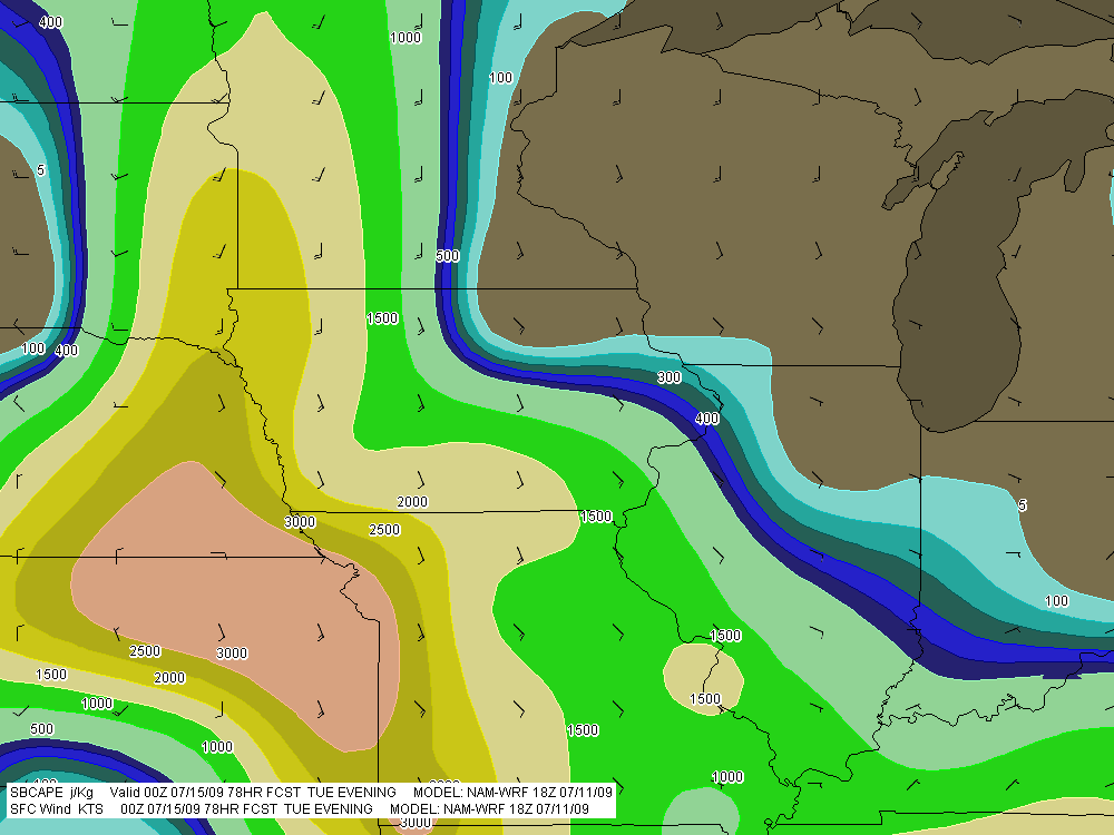
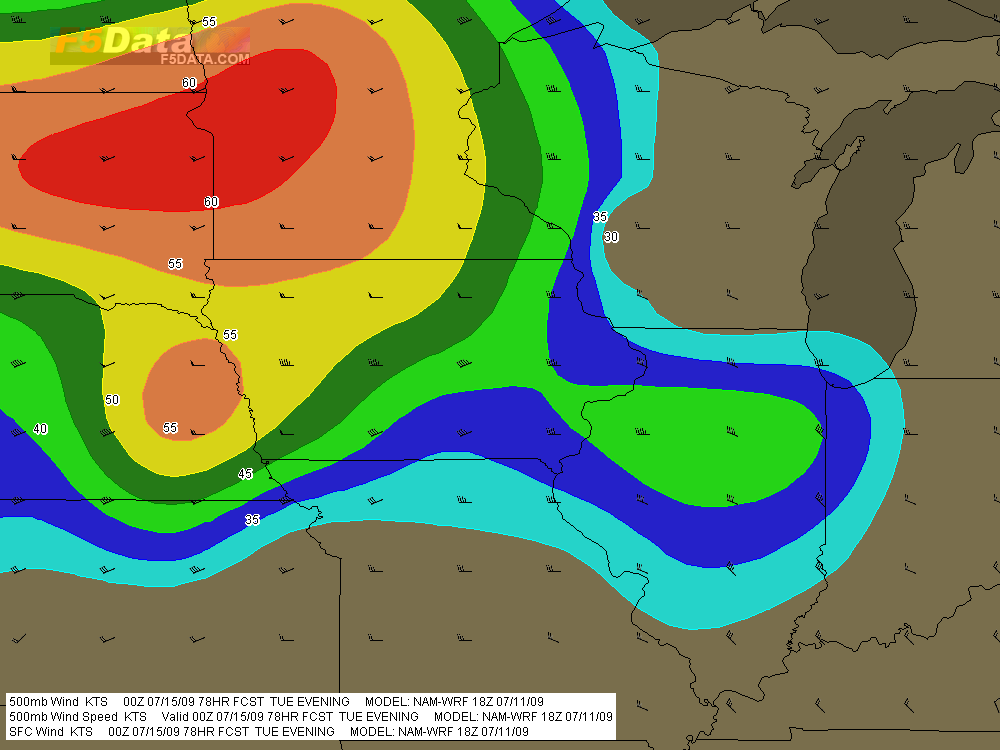
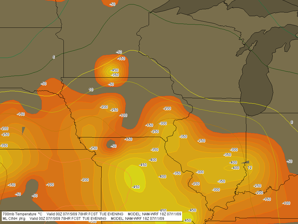
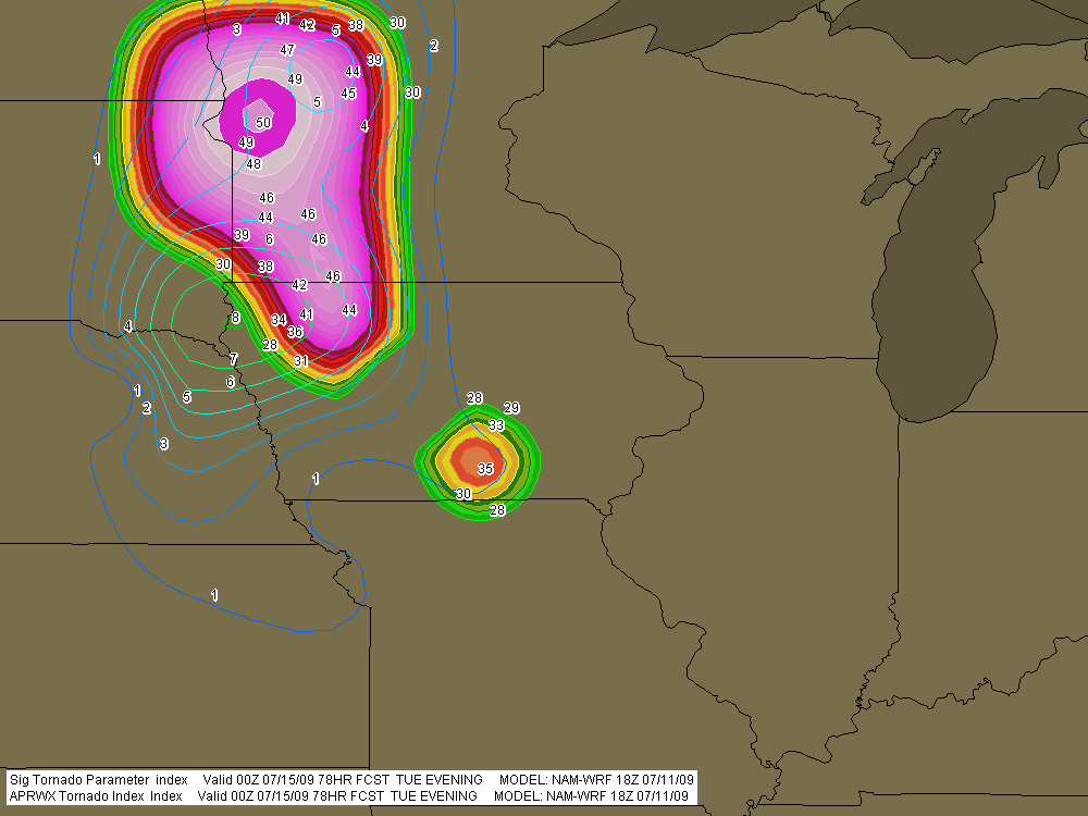
A significant weather event appears to be shaping up for the northern plains and cornbelt this coming Tuesday. For all you weather buffs and storm chasers, here are a few maps from the 18Z NAM-WRF run for 7 p.m. CT Tuesday night (technically, 00Z Wednesday), courtesy of F5 Data.

A couple items of note:

* The NAM-WRF is much less aggressive with capping than the GFS.  The dark green 700mb isotherm that stretches diagonally through central Minnesota marks the 6 C contour, and the yellow line to its south is the 8 C isotherm.

* The F5 Data proprietary APRWX Tornado Index shows a bullseye of 50, which is quite high (“Armageddon,” as F5 software creator Andy Revering puts it). The Significant Tornado Parameter is also pretty high, showing a  tiny bullseye of 8 in extreme northwest Iowa by the Missouri River.

Obviously, all this will change from run to run. For now, it’s enough to say that there may be a chase opportunity shaping up for Tuesday.

As for Wednesday, well, we’ll see. The 12Z GFS earlier today showed good CAPE moving into the southern Great Lakes, but the surface winds were from the west, suggesting the usual linear junk we’re so used to. We’ve still got a few days, though, and anything can happen in that time.

SBCAPE in excess of 3,000 j/kg with nicely backed surface winds throughout much of region.

SBCAPE in excess of 3,000 j/kg with nicely backed surface winds throughout much of region.

500mb winds with wind barbs.

500mb winds with wind barbs.

MLCINH (shaded) and 700mb temperatures (contours).

MLCINH (shaded) and 700mb temperatures (contours).

APRWX Tornado Index (shaded) and STP (contours). Note exceedingly high APRWX bullseye.

APRWX Tornado Index (shaded) and STP (contours). Note the exceedingly high APRWX bullseye.

Waking Up in Dallas

Morning. I’m still in bed, and from the next room, sounds of family are drifting through the door. I’m in Dallas with my sister Diane, visiting with my brother Brian, sister-in-law Cheryl, and little nephew Samuel. Since the last time I saw him, Sam has transitioned from babyhood to little-boyhood. He has acquired a vocabulary, a white baseball cap that it’s very important to wear (backwards or sideways, as is the custome), and a very cool train set that we played with last night.

My lady Lisa is holding down the fort back in Grand Rapids, where the weather is providing a much cooler contrast to the upper-90s heat that’s on the menu for this week here in north Texas. Chasing storms is of course out of the question. I’ve family to visit, a bit of work to do, and in any case, there are no storms. Summer has hit and the atmosphere is capped as tightly as an oil drum. On Stormtrack, chasers are bidding the 2009 chase season adieu. I note that the SPC has outlooked days 5-6, but they’re not using the kind of language that gets me very excited.

I’m keeping this short. I can hear the sound of forks clicking on breakfast plates. It’s time to shower up and get myself going.

What a Blast! Playing Sax with Francesca at the Grand Rapids Festival

What fun it was to play with Francesca Amari this afternoon at the 2009 Grand Rapids Festival of the Arts! And how nice to finally NOT get rained and hailed out. High clouds moved in, thickened and threatened and lenta somewhat somber feeling, but never produced so much as a solitary raindrop.

We played at the main stage by the massive, bright orange Alexander Calder stabile, “La Grande Vitesse,” which is the massive and graceful icon of Grand Rapids. Our 45-minute set included tunes from Francesca’s DVD Better Days, plus jazz standards such as “Fly Me to the Moon” and my own feature tune, “My Funny Valentine.” Our bass player, Dave DeVos, had another gig at the festival and was much missed. But Wright McCargar did a stellar job filling in the bottom end, a job no keyboard player relishes because of the limitations it imposes, but which serves when there’s no bassist.

I was pleased to see my mother and sister, Diane,  out there in the audience. It’s such a blessing to have their support.

So…now the festival is behind me, and I’m preparing myself to head for Nebraska in pursuit of storms. Looks like fellow Michigan storm chaser Mike Kovalchick will be joining me. We’ve got a long drive ahead of us. Sometime tomorrow, we’ll hook up Bill, Tom, Kurt, and a friend of Bill’s. The last time I chased was May 13. I am ready and raring, and I hope the weather roars. The SPC shows a 30 percent area in tomorrow’s outlook, mostly in Iowa.  The 18Z NAM suggests a more western play, but maybe that’ll change.

Right now, storms look like they may have initiated northwest of Des Moines, but what I’m seeing doesn’t look like much–yet. I’m about ready to reboot GR3 and take another look. The guys drove all night to make the play today. I hope they score big. But I have an idea that tomorrow is going to be the main act. And then there’s Monday. I’ll be really curious to see whether the Great Lakes gets the kind of weather the NAM has been suggesting.

Painted Trilliums and a Mid-Week Storm Chase

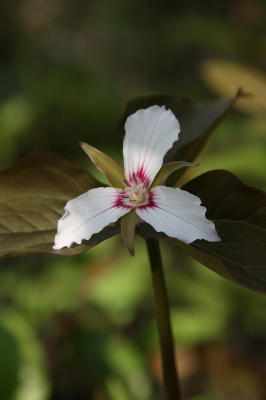
Painted Trillium

The painted trillium, trillium undulatum.

You’re looking at one of Michigan’s rarest wildflowers, the painted trillium.

With plans for a picnic in place and nothing but sunshine in the forecast for today, Lisa and I headed east with our cameras for a Michigan Nature Association preserve near Port Huron. The location is one of a handful where the painted trillium grows in this state, keeping company with the red trillium, which is also uncommon but far more widespread than its painted cousin.

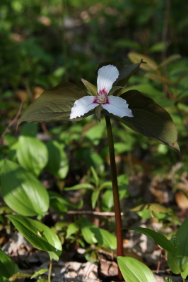
Good luck finding this in the Michigan woods!

Good luck finding this in the Michigan woods!

Out east in the Appalachians, the painted trillium is fairly common. But in Michigan, if you ever catch a glimpse of this plant, count yourself fortunate indeed. The images in this post are a prize, and it was a double blessing that I got to share the experience of capturing them with Lisa, who loves the outdoors as much as I do.

But enough eye candy. Turning from wildflowers to weather, Wednesday looks to be shaping up as a chase day in Illinois. It’s nice to see the action coming close to home. The question right now isn’t whether there will be a severe outbreak, but where will be the optimal chances for tornadic activity. With a strong cold front moving in, a squall line seems inevitable. But with the winds veering strongly from the surface up to 500 millibars, hodographs are nicely curved and helicities ought to be formidable. Play the warm front? Maybe. It’ll certainly be a tempting target, within easy reach of Grand Rapids. But I want to see what happens with clearing. It would be nice to see a buildup of CAPE in northern Illinois.

Wait and see is the name of the game. Right now all eyes are on the NAM and GFS. But Wednesday morning will tell. I’m crossing my fingers and toes and hoping to see signs of clearing on the satellite.