The Summer Pattern Is Setting In

The SPC has placed Michigan and the Great Lakes in a slight risk area for tomorrow. But tornadoes aren’t in the picture. The summer pattern appears to be setting in, with the jet stream moving its headquarters to the US/Canadian border. As far as Michigan is concerned, that’s close enough that we can still expect some decent kinematics here and there. But what we get tends to result in linear MCSs more than supercells and the like.

Tomorrow’s SBCAPE should settle in between 2,500 and 3,000 j/kg, with dewpoints in the 70s. That’s certainly an ample supply of convective fuel. And F5 Data shows this for H5 wind speeds at 21Z:
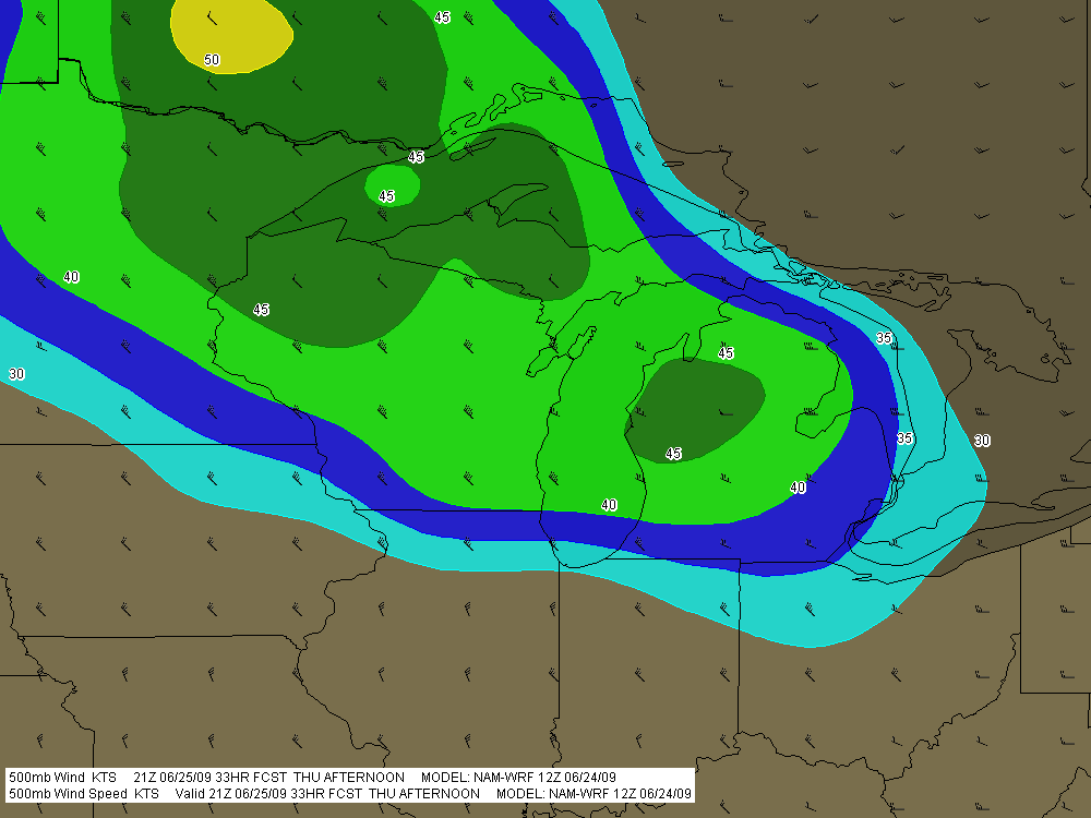
If you can live with northwest flow, that’s not bad. But of course, the underlying winds are all westerly. Once again, Michigan’s energy will get sabotaged by unidirectional winds. How pathetically par for the course! Maybe we’ll get some supercells, but we’re unlikely to see the low-level helicity needed to make them tornado producers. Probably better knock on wood when I say that, because the lake breeze zone can do some funny things with locally backed winds. Overall, though, I think the order of the day will be some nice, burly, ouflowish thunderstorms.

What do I know, though? I’m still pretty green as a forecaster, and I recall a couple years ago when the models showed a unidirectional setup with nothing in the way of helicities, and an F3 tornado ripped through Potterville.

One of the nice things about living in Michigan this time of year–among the many wonderful advantages of this beautiful state–is that we’re prone to get a couple supercellular events when the traditional Tornado Alley of the Great Plains simmers under a titanium cap. Those occasions aren’t anything you can count on, but it’s nice when they happen–for me and my fellow storm chasers, anyway. I suppose other folks here might see things a bit differently.
June 7 Northwest Missouri Supercell

Now that I’ve had a chance to rest up and catch up after Sunday’s chase in northwest Missouri, it’s time to do a writeup. I’ll summarize by saying that there were no tornadoes, but there was some great structure along with hail the size and disposition of wild boars.

My plan was to hook up with Bill, Kurt, and Tom, who had headed west a day ahead of me in anticipation of chaseworthy storms. Unfortunately, a stout cap quashed an otherwise potent setup, and the guys–along with lots of other storm chasers–endured a blue sky bust. Like I told Bill, they needed me out there with them to erode the lid for them.

I left around 10:00 Saturday night and drove as far as Davenport, Iowa, where I overnighted. The next day, I hightailed it for Topeka, Kansas. Bad route choices delayed my arrival, and storms had already initiated by the time I got within the vicinity. But that actually simplified my choice. Rather than heading into Kansas, I worked my way north of Saint Joseph, Missouri, along I-29, then hit the backroads to intercept a supercell that was making its way across the border near Rulo, Kansas.

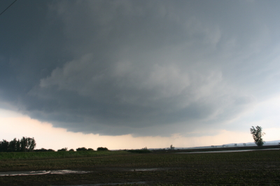
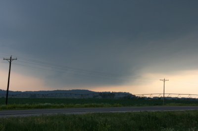
Parking my car outside of Big Lake, Missouri, I set up shop and got some nice photos as the storm moved in. The base was lowering and developing a rotating wall cloud. Here is what the storm looked like when I took my first shot.

Wall Cloud at Big Lake, Missouri, June 7, 2009

Wall cloud at Big Lake, Missouri, June 7, 2009.

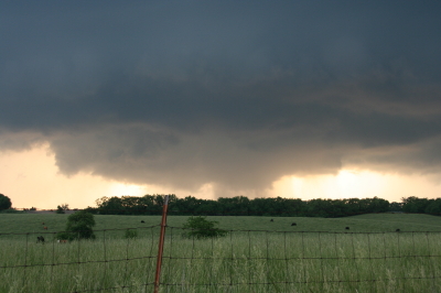
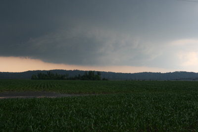
The cloud was southwest of me and moving eastward, which meant that I could expect plenty of rain and probably a good clobbering by hail. In a little while, sure enough, golfballs began to fall all around me. No rain, just sizeable hail. The cloud at this point was directly to my south and looked like this:

Wall cloud passing to the south.

Wall cloud passing to the south.

It was time to vamoose, and none too soon. The advance guard of a veritable armada of storm chasers was driving by. I pulled in behind the DOW (Doppler On Wheels) and other Vortex 2 vehicles and followed them toward Forest City. By the time I reached SR111 and began heading south, I had pulled ahead of the circulation. I wanted a few photos of the wall cloud advancing directly toward me, so I found a place to pull aside. Opening the car door, I stepped out into some ripping inflow and snapped a few shots.

Wall cloud approaching SR 111 north of Forest City.

Wall cloud approaching SR 111 north of Forest City.

I missed the really big, gorilla hail that some chasers encounterd, but the occasional baseball size was big enough for me. Somehow I escaped getting hit by the larger chunks, though one of them hit my roof squarely with a loud whack. I still haven’t checked to see whether there’s a dent.

Eventually I caught up with the guys at the I-29 overpass, where a zillion other chasers were also parked. Seems like everybody and his dog’s first cousin was on this storm. If I ever get rich enough to purchase a dedicated chasemobile, it won’t be an SUV or a TIV-style monstrosity. It’ll be a concession van with a fold-out bar.

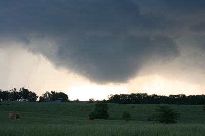
Anyway, Bill, Tom, and Kurt forged ahead and I followed them for a ways, but eventually opted for a more southern route when they headed north toward Union Star. I figured they’d be hitting heavy precip and probably some nasty hail, and I wanted to stay on the south edge of the updraft, which was heading east by southeast. Here are a couple photos from what was, from my vantage point, one of the more promising episodes in the life of the storm.

Wall cloud with clear slot wrapping in.

Wall cloud with clear slot wrapping in.

Possible funnel cloud trying to develop.

Possible funnel cloud trying to develop.

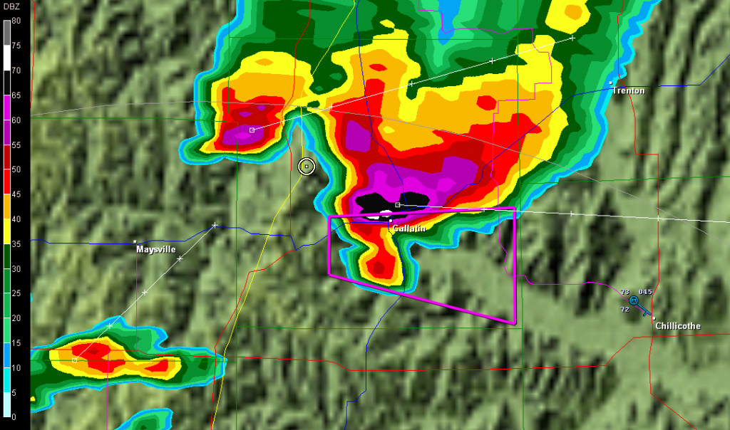
I believe the above shots were taken near Amity. From there, I headed east through Maysville and Weatherby, and across I-35 to just west of Altamont. There, I decided to end the chase and start heading home. The storm at that point was heading into Gallatin and was showing one of the best reflectivity echoes of its career on GR3.

Base reflectivity showing tornado-warned storm approaching Gallatin.

Base reflectivity showing tornado-warned storm approaching Gallatin.

But darkness was closing in, and I had no desire to chase this storm at night through the hinterlands of northwest Missouri. At that point, I was thinking about overnighting in Des Moines, and I had miles to go before I slept.

Tribute to a Storm Chasing Partner

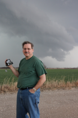
Wild Bill Oosterbaan, Chase Partner Extraordinaire

Wild Bill Oosterbaan, Chase Partner Extraordinaire

I contemplated cropping the above image to achieve a better visual balance. Then I thought, nah. For one thing, what’s the point of trying to balance the photo of a character who’s as wildly off kilter as Bill. For another, and all kidding aside, I’d have to trim out a good portion of the storm clouds. And that would be like trimming out the very essence of Bill Oosterbaan. You see, clouds like those are Bill’s passion. They’re what first brought us together thirteen years ago, and they’ve been propelling us across the miles ever since in search of convective mayhem.

Bill is my chase partner. Of course, I chase with some other great friends and storm chasers as well, but Bill…well, I’ve just covered more miles with him by far, paid more dues, experienced more busted chases, learned more about weather, and yes, seen more tornadoes and beautiful storms, than with anyone else. This post is my tribute to my fellow chaser, comrade in convection, and good friend of over a decade.

Bill and I are very different temperaments. Conduct a Meyers-Briggs personality profile of each of us and your first conclusion probably wouldn’t be that we ought to get in a car together and travel 1,000-plus miles at a stretch in search of intense, potentially lethal weather. But we’ve survived both the storms and each other, and learned quite a bit in the process. And, I might add, we’ve had a heckuva lot of fun.

I first met Bill back in 1996. That was the year I also conducted my first successful storm chase right here in Michigan. I had already done a chase or two with Bill and his brother, Tom, but on that sticky August day, the two of them were out on the golf course. So when a supercell fired up and formed a wall cloud right outside the window where I worked, I drove solo across the Kent and Ionia County countryside and scored a slim, elegant tube tornado north of Saint Johns.

On my chases since then, though, I’ve rarely been without Bill. So our development as storm chasers has followed a very similar track. I saw my first Great Plains tornado with Bill. In 2005 we chased the record-breaking Six State Supercell together from west of Columbia, Missouri, all the way back to Michigan. On two separate occasions, we’ve witnessed nighttime tornadoes strike large towns. Our technology has advanced from a miniature TV and stop-offs at airports  and libraries in order to access radar data, to laptops equipped with all the tools known and loved by storm chasers today. We’ve even figured out how to use most of the stuff. Our forecasting skills have grown from those early days of trying to decode the arcane language of SPC discussions, to making our own forecasts with increasing success.

Lately my laptop of four years has been giving me fits. This is  nothing new, but it has gotten to the point where I’ve finally ordered a new one from Dell. It’s a heavy-duty toughbook that’s made to take punishment, perfect for the road. Bill sees  in it the end of an era. He says he’s going to miss watching my eyes bulge and the veins pop out in my neck. I hate to deprive him of such a simple pleasure; it’s a small thing, and it causes him so much joy. On the other hand, I think he’ll agree that there’s a lot to be said for having a computer that doesn’t crash when we need it most. Typically that happens while we’re in pursuit of some rain-wrapped meso with who knows what lurking in its interior.

I look forward to tracking down plenty more mesos with my friend and long-time chase partner. Many more storms, countless more hours on the road, and yes, more arguments with the ornery cuss. Because the storms are what it’s about for both of us, and I think we’ve learned–and will continue to learn–plenty from each other about chasing them. Our respect for one another is mutual, as is our love for the wild, untamed beauty of Big Weather. When Bill and I talk, it’s mainly about storms. We never get bored. For us, talking about the weather is far from trivial conversation. There’s always something new to learn, something fresh to discover.

That’s why I refuse to trim those storm clouds out of the picture up above. To lessen their presence would be to lessen the story they tell about the man standing in front of them. They’re a vital part of Bill. So let the clouds remain and let the picture look a bit unbalanced. After all, Bill’s a storm chaser. What kind of balance do you expect out of a guy who hunts tornadoes?

Bill, mi amigo, it sure has been a blast. Here’s to you. Here’s to shared experiences, to the thousands of miles we’ve driven, and to the thousands we’ve yet to drive. Here’s to the the Lord who has kept us safe and blessed us with success.

And, as always, here’s to the storms.

May 13 Tornado in Northern Missouri

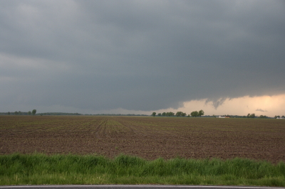
Updraft Base

Updraft Base

This is the view that met us as we pulled off the road a couple miles north of Edina, Missouri, yesterday evening. “We” were Bill Oosterbaan, Derek Mohr, and me, and what we were looking at was the only supercell in Missouri on Wednesday, May 13, to produce a tornado–this despite a sizeable moderate risk that swept across most of Illinois and Missouri all the way down to Kansas and Oklahoma.

The storm was showing strong rotation, and had already put down a damaging tornado twenty miles to our west in Kirksville. We lost Internet connection as we approached the storm, but our last scan showed what appeared to be a storm merger with two distinct areas of rotation. The radar didn’t lie, and the proof of it provided an interesting scenario.

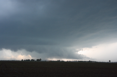
Wall Cloud Forming

Wall Cloud Forming

In the second image, you can see a ragged patch of scud ascending to the right and in front of the lowering in the background. This is the beginnings of what became an impressive wall cloud. Within a couple of minutes, the scud had matured into this…

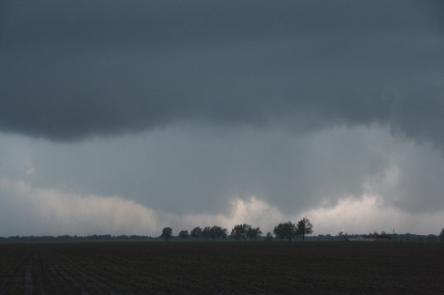
Wall Cloud

Wall Cloud

The tail cloud to the right continued to grow to an astonishing length, displaying vigorous motion, feathering in rapidly toward the updraft. Meanwhile, a rain curtain began to wrap in from the south behind the wall cloud. This suggested a second mesocyclone following in the wake of the first area of rotation. I commented on this in the video I took of the storm, and my hunch soon proved true.

As the storm drew nearer, another prominent lowering began to emerge. It was exhibiting rapid motion, moreso than the more visually interesting wall cloud in the foreground. A tornado appeared immanent within this broad rotation, and in another minute multiple vortices were square dancing in the distance. One vortex soon tightened up and became dominant, fattening up into a nice hose. But the rain bands were starting to conceal the tornadic activity, and in a bit it was hard to tell exactly what was happening.

The storm quickly evolved into a nasty high precipitation beast, and from then on any tornadoes were effectively cloaked in rain.

Sorry, no stills of a well-formed tornado–I had set my camera down in favor of my video recorder–but I did manage to capture what looks to have been the beginnings of the multiple vortex phase.

Multiple Vortex Tornado

Multiple Vortex Tornado

No, you can’t see any visible touchdown in the photo, so maybe the circulation wasn’t tornadic at that moment.  If not, it was shortly after. I sure wouldn’t have wanted to be standing underneath it.

After the chase, Bill dropped Derek and me off where we had left our cars at the K-Mart in Springfield, Illinois. Then the three of us headed off in our respective directions–Bill toward Corydon, Indiana; Derek toward northern Michigan; and I back toward Grand Rapids. On my way home, I picked up fellow Michigan chasers Mike Kovalchick and Mike Bishop. They had experienced an automotive failure that took them out of the chase, forcing them to ditch their vehicle in Lincoln–truly a bummer. It was great to reconnect with Mike Kovalchick, and to meet Mike Bishop for the first time. Having a couple fellow storm chasers in the car sure made the long trip home seem shorter.

The day out chasing did me a world of good, but I need a good night’s sleep, and I have work to do tomorrow. By the time the next round of weather arrives, though, I should be primed and ready to go.

Moderate Risk in West Oklahoma and Texas

My buddies Bill and Tom Oosterbaan and Derek Mohr are heading for today’s sweet zone out in western Oklahoma. The Storm Prediction Center has placed the area under a moderate risk, with an indication of strong tornadoes. No doubt. With CAPE exceeding 2,000 and decent helicity and upper-level support increasing by 0Z, all the ingredients will be there. I’d imagine the guys will be playing the triple point per the SPC, where helicity will be maximized. Should be quite the caravan out there today. A person with a popcorn truck and GR3 could make a killing on a chase day.

Farther north, back here in Michigan, we’re sitting under our first light risk day of the year. As I write, it’s approaching 11 a.m. and the temperature is already in the upper 70s with dewpoints tapping on 60 degrees. But the forecast soundings look miserable, with adequate bulk shear but squat in the way of directional turning and some truly weird-looking hodographs. The sounding for 21Z out in the east central Texas panhandle, on the other hand, out around Mobeetie and Wheeler, looks great.

Sigh.

Well, we’ve got rain outside. Big drops.

At least “the kids”–my collection of carnivorous plants–will be happy. I just potted my three latest arrivals: a parrot pitcher plant, a maroon-throat variety of the pale pitcher plant, and the Gulf variety of the sweet pitcher plant. They’re sitting out on the deck along with the rest of my little family, soaking in the warmer temperatures, humidity, ambient light, and now the precip. It’s a fine day for the plants here in Michigan, and a good one as well for writers and jazz musicians if not storm chasers.

Time to fire up the radar and see what’s on the way.

Convective Inhibition: SBCINH vs MLCINH

Some months back, I wrote a review of F5 Data, a powerful weather forecasting tool that aggregates a remarkably exhaustive array of atmospheric data–including over 160 different maps and a number of proprietary indices–for both professional and non-professional use. Designed by storm chaser and meteorologist Andrew Revering, F5 Data truly is a Swiss Army Knife for storm chasers, and thanks to Andy’s dedication to his product, it just keeps getting better and better.

My own effectiveness in using this potent tool continues to grow in tandem with my development as an amateur forecaster. Today I encountered a phenomenon that has puzzled me before, and this time I decided to ask Andy about it on his Convective Development forum. His insights were so helpful that, with his permission, I thought I’d share the thread with those of you who are fellow storm chasers. If you, like me, have struggled with the whole issue of CINH and of figuring out whether and where capping is likely to be a problem, then I hope you’ll find this material as informative as I did.

With that little introduction, here is the thread from Andy’s forum, beginning with…

My Question

SBCINH vs MLCINH

I’m looking at the latest GFS run (6Z) for Saturday at 21Z and see a number of parameters suggesting a hot spot around and west of Topeka. But when I factor in convective inhibition, I get either a highly capped environment or an uncapped environment depending on whether I go by MLCINH or SBCINH. I note that the model sounding for that hour and for 0Z shows minimal capping, which seems to favor the surface-based parameter.

From what I’ve seen, SBCINH often paints a much more conservative picture of inhibition, while MLCINH will show major capping in the same general area. How can I get the best use out of these two options when they often paint a very different picture?

Andy’s Answer

This is a great question, and very well worded… I guess I should expect that from a wordsmith!

SB *anything* is calculated using a surface-based parcel. ML *anything* is calculated using a mixed layer parcel. It is done by mixing the lowest 100mb temperature and lowest 100mb dew points and using those values as if those values were the surface conditions, and then raising from those values.

This is why when you look at a sounding it looks to favor the SB CIN because the parcel trace on those soundings is always raised from the surface. If you were to ‘average’ or mix the lowest 100mb temperatures by simply finding the section of the temperature line that is 100mb thick at the bottom of the sounding, and find the middle of that line (average value) and see what that temperature is, and then go to the surface and find where that temperature would be on the sounding at the surface, and raise the parcel from there (after doing the same thing with the dewpoint temperature) then you will have the ML Parcel trace and would then have MLCIN and MLCAPE to look at in the sounding.

A drastic difference in capping from SBCIN to MLCIN indicates that there is a drastic difference in values just above the surface that are causing this inconsistency. So when the parcel is mixed it washes out the uncapped air you get from the surface value.

We have different ways of looking at these values with different parcel traces because quite frankly, we never know where this parcel is going to be raised from. The same idea is why we have Lifted Index and Showalter Index. ITs the same index, but Showalter uses the values at 850mb and pretends thats the surface, while Lifted Index uses the surface as the surface.

We just never know where the parcel is going to raise from.

It seems to be consensus that ML-anything is typically the favored parcel trace. This means smaller CAPE and bigger CIN usually.

I have stuck strictly to my APRWX CAP index for years now because it considers both of these, as well as the temperature at 850mb, 700mb, and temperatures at heights from the surface up to 3000m, cap strength/lid strength index, as well as some other things when looking at capping. It seems to perform very well.

To summarize though… capping is a bear. If anything is out of line, you’ll easily get capped. So what I do is look at every capping parameter I can, and if *anything* is suggesting it being capped, then plan for it to be capped during that time period.

Now to confuse the situation even more, keep in mind that capping only means that you won’t get a storm to take in parcels from the suggested parcel trace location… IE.. from the surface. You can be well capped and have elevated storms above the cap. However for them to be severe you tend to need ‘other’ parameters in place, such as very moist air at 850mb (say 12c dew), some strong winds at that level, etc. to feed the storm.

Another map that is neat to look at for capping is the LFC-LCL depth. You may be capped, but want to be in position where the cap is ‘weakest’ and may have the best chances at breaking… with this map you get into your area of interest and then look at this map and find where the LFC-LCL depth is ‘smallest’.

For a capped severe situation, this usually means high values with a donut hole of smaller values in the middle. This is a great indication that the cap would break most easily in the middle of that donut.

This map (in a different, but similar form) can be seen on the SPC Mesoanalysis web site as LFC-LCL Relative Humidity. Its the same idea, but on their map you want high humidity values for weakening cap indication.

——————

So there you have it–Andy’s manifesto on capping. It’s a gnarly subject but an important one, the difference between explosive convection and a blue-sky bust. There’s a lot more to it than looking at a single parameter on the SPC’s Mesoanalysis Graphics site. If nothing else, this discussion has brought me a step or two closer to knowing how to use the ever-increasing kinds of forecasting tools that are available.

Elkhart County Historical Museum Remembers the 1965 Palm Sunday Tornadoes

My friend Debbie Watters, prorieter of the 1965 Palm Sunday Tornado Memorial Park in Dunlap, Indiana, sent me the following article from the Elkhart Truth newspaper:

It’s been almost 44 years since the Palm Sunday tornado tore through Elkhart County, killing dozens and injuring hundreds. It will be the focus of a special program at a local museum.
The Elkhart County Historical Museum is organizing a remembrance of the April 11, 1965, di saster. The memorial will be from 2 to 4 p.m. April 5 at the museum, 304. W. Vistula, Bristol.
Nicholas Hoffman, director and curator of the museum, said the tornado is an important part of local history.
“It was a really big occurrence that impacted many people,” Hoffman said.
Patrick Murphy, a meteorologist from the National Oceanic and Atmospheric Association, will talk about how tornadoes form and the factors that led to the 1965 tornado outbreak that spawned 40 tornadoes across the Midwest and left 271 people dead.
“We’re really excited to have NOAA participating in this event with us because they’re certainly the experts on these events,” Hoffman said.
A panel of survivors of the Palm Sunday tornado will take questions after Murphy’s presentation.
The panel will include John Clark, a retired Elkhart police officer, and Paul Huffman, the retired Elkhart Truth photographer who snapped the famous photo of the twin twisters.
“[Huffman] captured the horror of that day with one photograph,” said the curator.
There will be an open microphone portion for anyone interested in talking about the disaster.
The museum will also provide table space for collectors to display items they found in the wake of the tornado.
For more information call the museum at 848-4322.
Of course I plan on attending. My interest in the Palm Sunday Tornadoes extends back to my childhood, and in recent months it has become an area of increasing research. I am particularly excited to learn that Paul Huffman–whose photograph of the twin funnels striking the Midway Trailer Court, remains one of the most dramatic, all-time classic tornado photos ever taken–will be one of the panelists. That’s just my opinion, but I think that many severe weather meteorologists, tornado historians, and storm chasers will agree. Over the years I have viewed hundreds of tornado photos. I have seen some incredible images, ranging from the sublime to the scary, but nothing quite like that old black-and-white snapped over forty years ago by a young press photographer as he stood in the inbounds with his camera just a few hundred yards from mayhem, witnessing the last moments of a community.
I hope to get a chance to talk with Mr. Huffman. I also look forward to meeting Pat Murphy, lead forecaster for the Northern Indiana NWS. He and I have connected previously concerning the Palm Sunday Tornadoes, and have made plans to get together next week Sunday, April 11–the 44th anniversary of the outbreak–to trace the paths of some of the twisters. But that’s a separate story, and while this is an area of personal fascination for me, there’s also another, parallel motive which I’m hesitant to divulge just yet.
Stay tuned, though. You’ll be reading more about the 1965 Palm Sunday Tornadoes in this blog.
And on that note, I invite you to leave a comment if you experienced the Palm Sunday Tornadoes firsthand. If you are a storm survivor, or if you possess personal, unpublished photographs or old film footage of one of the actual tornadoes, I would love to hear from you.