Tornado Video Resembles Paul Huffman’s Famous Twin-Funnels Photo from the 1965 Palm Sunday Outbreak

On April 11, 1965, Elkhart Truth photographer Paul Huffman parked his vehicle by the side of US 33 northwest of Goshen, Indiana, and began snapping pictures of a tornado passing within a half-mile of him. One of those images, captured as the twister was in the process of devastating the Midway Trailer Park, became what is probably the most famous tornado photograph ever taken, and the icon of the nation’s second deadliest large-scale tornado outbreak. Paul’s image of twin funnels straddling the highway is instantly recognizable to anyone familiar with the 1965 Palm Sunday Outbreak.

Like countless weather weenies, I’ve been fascinated with Paul’s photo. As a storm chaser, I’m familiar with multiple-vortex tornadoes. Today meteorologists understand that they’re fairly common. Yet multiple vortices take all shapes, sizes, and behaviors, and I’ve always been on the lookout for something that seemed to approximate what was probably happening in Paul’s photograph (really his series of photographs depicting a single funnel undergoing vortex breakdown into the infamous “twins”).

Just a few minutes ago, I came across a new YouTube video that is the closest I’ve ever seen to what the Midway tornado–and very likely the one that hit Dunlap 45 minutes later–may have been like. I don’t normally feature YouTube videos in this blog because I hate discovering that the video I had included in a post a year ago no longer exists. But besides being truly impressive, this clip is just too strikingly reminiscent of Paul’s historic photo to pass by.

The video was shot just yesterday in southeast Oklahoma by storm chasers Marc Austin, Robert McIntyre, and Gabe Garfield. At 1:08 into their clip, you can see two large twin funnels embedded in the parent circulation. It’s a spectacular display, and my hat is off to these guys for catching the storm of the day. Tragically, the tornado killed at least one person and caused significant damage in the towns of Tushka and Atoka.

The system that produced the Tushka/Atoka tornado and a number of others yesterday is moving east today. Mississippi and Alabama lie within a moderate risk, with a good possibility of strong to violent tornadoes. The storms are ongoing this morning as I write, and a whole day lies ahead of them for moisture and instability to build across Dixie Alley. It’s not a pleasant prospect. Let’s hope that the damage will be minimal and no more lives will be lost.

Backing Winds: Really Necessary for Tornadoes?

That’s right, fellow storm chasers, you read my headline right. I’m about to raise a few eyebrows by tossing out the possibility that backing winds–or, more precisely, what we normally consider to be backing winds as depicted on forecast maps–aren’t always vital to tornadic storms.* This isn’t speculation as much as it is observation. Over the years I’ve seen a number of tornadic events develop in the midst of southwest surface flow, enough to think that the absence of southeasterly winds on the forecast map isn’t always a deal breaker.

What is indispensable are the conditions that southeasterly boundary layer winds tend to create. I’m thinking of ample deep-layer moisture and sufficient low-level storm-relative helicity. Those are what count. If they are present, it doesn’t much matter which way the wind blows from our perspective. The atmosphere sees things differently and doesn’t care what we think. It just does what it does.

Let me quickly say, I’m a huge fan of southeasterly surface winds. I love to see them on forecast maps. And I’m aware that winds can back locally in ways that the maps don’t portray. What I’m really talking about here is forecasting using the tools we have to work with, which continue to improve. Until last year, for instance, I’d never heard of the HRRR. It’s a marvel. But generally speaking, in contemplating the prospects for a chase day we’re still dealing with pretty broad brush strokes, and the farther we live from Tornado Alley, the better we need to be at determining how those strokes will play out.

A Regional Thing?

In writing about forecasting matters, I still feel very much like a neophyte who may be getting into matters that are over my head. I’m no Jon Davies or Chuck Doswell. I’m not even a meteorology student. But you know the old saying about fools, angels, and where they tread.

My sense of things is that as we move east of the Mississippi, southeasterly surface winds become less important for moisture fetch–and, I might add, southwesterly 850s aren’t such a terrible thing. Why? For one thing, moisture sources in the Gulf of Mexico no longer lie to the southeast, but to the south, and even to the southwest in eastern parts of the CONUS. Also important, the desert southwest isn’t nearly so proximate an influence. Thus, H85 winds that would kill a setup with dry air advection in Oklahoma can carry moisture up into Illinois and Indiana. Moreover, that moisture is apt to follow a curvy path–one that can, for instance, take it first northwest from the Gulf, then north, then northeast up into the Great Lakes.

All that to say that the trajectory of moisture transport can look different in different parts of the country.

As for helicity, does it really matter whether you’ve got southeasterly, or even southerly, surface winds as long as 0-1km SRH is in the neighborhood of 150 or greater? Years of reading convective outlooks leads me to believe that the SPC doesn’t think so.  What I’m saying here is no doubt old hat to them. But it may seem a bit out of the box to at least some storm chasers, particularly those whose thinking has been conditioned by setups in the southern and central Great Plains. The whole concept of storm-relative helicity suggests that the term backing is, well, relative, a matter of how winds relate to a storm as it moves, not to the compass. That’s why right-turners produce. A few days ago in Pennsylvania, overall storm motion was consistent with unidirectional winds from the west; yet a rogue supercell deviated to the right and spun up a tornado near Greensburg.

A Few Examples

Seeing is believing. Here are a few maps that show surface conditions around the time of tornado incidents east of the Mississippi.

july-13-2004-roanoke-ilThe July 12, 2004, Roanoke, Illinois, tornado is an example of a classic northwest flow event. Rated F4, the tornado was large, long-lived, and not the first violent tornado to occur in northwest flow during the warm season in Illinois. Four years earlier, the disastrous 1990 Plainfield F5 was fueled by massive CAPE amid northwest flow.

june-5-2010-elmwood-iljune-5-ilx-pm-soundingThe June 5, 2010, central Illinois outbreak was a sort of quasi northwest flow situation. Mid-level winds were predominantly westerly with just a slight northerly component to them. The surface and 850 winds were unquestionably veered. Besides the surface map, I’ve also included the ILX 00z sounding, which preceded tornadogenesis by roughly an hour.

august-24-2007-pottervillepotterville-500mb-12zFinally, the Potterville, Michigan, tornado practically dropped in my lap, but I ignored what the radar was showing me because I was too dumb to believe my eyes even when the dynamics were plainly visible in the clouds right over my head. This was not a northwest flow event; in fact, as you can see by comparing the surface and 500mb maps, it looked to be unidirectional from the southwest, with directional shear increasing as the trough moved east and mid-level winds became more westerly.

You can find plenty more examples besides these, I’m sure. My point is simply this: Don’t be too quick to write off a synoptic setup because of veered surface winds in the forecast, particularly east of the Mississippi. If moisture is in place and there’s reason to hope for adequate SRH, then it can pay to take a deeper look. Things could pop. They’ve done so before and they’ll do so again.

_______________

* ADDENDUM, March 3, 2013: The term “backing” has a couple of different applications. I used it a bit naively in the title and copy to mean southeasterly surface winds, which is the meaning by which I first came to understand the word. That becomes apparent quickly  in the article, but it bears explaining. If I were writing this  post today, I’d simply say “southeasterly” and erase any uncertainty of what I meant.

March: When Daylight Lengthens

Today is March 6, and between the first day of the month till now we have already gained fourteen minutes of daylight here in Caledonia, Michigan. By the end of the month, that figure will have grown to an hour and 29 minutes–52 minutes in the morning and 37 in the evening. That averages out to a gain of around 2.9 minutes every day.

March is the month when daylight happens.

Small wonder that storm chasers do a happy dance when March 1 arrives. It’s designated the beginning of meteorological spring for good reason. Henceforth the days are poised to lengthen rapidly. The sun is climbing higher in its arc over the northern hemisphere, putting in a longer workday and shining more intensely. That means warmer temperatures, juicier dewpoints, and increasing instability. Things start happening. The new storm season’s convective pump is getting primed, and preludes of the next few months start showing up on the radar.

So why complain about March? It may not be pretty, but it loves ya.

Skunk Cabbage Time

Snow may still be covering the ground here in West Michigan, but meteorological spring has sprung and March is on the march. Temperatures are trending warmer, and while the mid to upper thirties may not be anything to brag about, the vernal transition is at hand. You can see it in the mist lying over the snowfields. You can hear it in the spring songs of a few optimistic early-birds. It’s there on the weather maps in the form of lows sweeping northeastward out of the Plains, tugging moisture up out of the Gulf of Mexico. And soon, those of us who love native plants will discover it poking up through remnant drifts in wooded swamps in the form of Michigan’s earliest wildflower, the skunk cabbage.

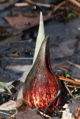
Symplocarpus foetidus may not be bouquet material, but I’m fond of it. Too low-key to be striking, skunk cabbage is nevertheless remarkable, a demonstration of genius walking hand in hand with humility. Its small, odd-looking, purple-cowled flowers, rising amid the languishing snow drifts in mid to late March here in the north, resemble nothing else the woodland has to offer. Once I see them, I know that spring has gotten truly, irrevocably underway. (Click to enlarge image.)

Indeed, as spring’s first flowering harbinger, skunk cabbage makes its own modest contribution to the ambient temperature through its unique ability to generate heat. Skunk cabbage flowers literally melt their way through the snow, generating temperatures upwards of 70 degrees in their immediate vicinity. These little heat engines serve as microclimates for certain insects; each bloom is, in a sense, a world unto itself.

Speaking of the blooms, the mottled hood that resembles a monk emerging headfirst from the earth is not the actual flower. It is a structure called a spathe, and it wraps around the stubby yellow spike on which the tiny flowers grow.

Tear off just a small piece from any part of the plant–the spathe or, in a few more weeks, the large, lush green leaves–and give it a sniff. You’ll instantly discover how the skunk cabbage got its name. It’s not a plant known for its mild, winsome aroma.

The lowly skunk cabbage may rank as America’s oldest flowering herb. Speculation is that, in a supportive environment, Symplocarpus foetidus may live for hundreds of years. That stand of skunk cabbage you traipsed past without giving a second thought to on your hike through the woods may have gotten its start before the Mayflower landed!

Storm chasers greet the spring looking up at the sky, sniffing the moisture returning from the Gulf of Mexico and watching for tumbled clouds to rise through the troposphere and throw tantrums of thunder, lightning, and hail. But it pays to look down as well. The advance guard of spring’s convective pyrotechnics may be an unobtrusive little plant peering up at you beside a snow drift in the woods.

Yet Another Update: Huge Progress!

I know I’ve been posting a lot of status updates concerning Stormhorn.com. Maybe I’m guilty of overkill, but I feel it’s better to let you know what’s going on with this blog than keep you wondering.

And the fact is, a LOT has been going on. I should have scrapped my old NexGen plugin weeks ago, done the reinstall, and gotten on with replacing my image files. I didn’t because all I could think was, “Oh, man, all those files!” Nearly 500 of them. But as it turns out, reinstalling them hasn’t been nearly the prolonged hassle that I thought it would be–not that it isn’t time-consuming grunt work, but the process is moving along just fine. Much better, in fact, than I expected.

Image Files Are Now Largely Restored

That’s right–I’ve got the bulk of my galleries back in place. The work certainly isn’t finished, but right now, if you go to my photo page, you’ll see that most of what used to be there is back where it was. Well, sort of. I took the opportunity to do a little reorganizing, but that’s a good thing that brings a little more order to my collection. Anyway, just about all of my storm photos are back in place. Ditto my wildflower, bird, and other images. Check ’em out!

The CopyFox Has Reopened for Business

One of the worst parts of this whole debacle was having to take my CopyFox page and subpages offline. There was no alternative. Nothing looks worse than a copywriting business site that’s having communication issues!

But huzzah! The days of woe are past and the time of jubilation is at hand! The CopyFox now has its very own website, which is how things should have been from the beginning. Bang the drums, bring on the jugglers and dancing bears, and let there be music in the streets! And by all means, check out the site at www.thecopyfox.com.

What Still Needs Doing

Now that I’ve got the bulk of my image files downloaded, I need to sift through my posts one by one and restore images to their proper places. There are also plenty of galleries that still need to be downloaded.

But so much has already been accomplished. This blog is essentially well on its way to complete recovery. And even as I sort backwards through past posts, you may notice that Stormhorn.com is also moving ahead with new posts that will keep storm chasers current on the incoming spring weather season and equip jazz musicians with fresh food for thought and material for the woodshed.

So there you have it. The news is all good. Thanks for your continued interest and loyalty to this site as it endures its growing pains. I’ve been amazed and encouraged to see that traffic has not only remained consistent through the worst of it, but now appears to be experiencing some impressive growth. Having changed to a new web host, I’m not sure yet how accurate my WordPress stats are–perhaps they are inflating the numbers and need to settle in a bit; but I think that Awstats is pretty dependable, and assuming that’s the case, then March is off to an awesome start.

So again, thanks for bearing with me. And stay tuned, because repairs are being made rapidly at this point.

Goodonya,

Bob

This Year’s Regional Focus for Tornadoes: What Do YOU Think?

My last post has now got me thinking ahead to the spring weather season. I’m going to do something I haven’t done before on this blog: rather than share my thoughts, I’m going to ask you for yours.

Here’s the question: What part of the country do you think the focus for tornadoes will be this year? Southern plains, northern plains, farther east…where and how do you think things will play out, and why?

This isn’t a hardcore survey. It’s for fun and curiosity to see how people think. Please click the “comment” tab to respond. If I get a few meaty, thoughtful responses, I’ll share the highlights and interact with them in another post.

Bear in mind that this is a La Nina year. While no research exists that solidly establishes a link between La Nina and tornado outbreaks east of the Mississippi, nevertheless statistics show a correlation. It’s one among various things to consider in what will probably still end up as a roll of the dice. The weather just doesn’t care about our reasonings! But it’s still fun to think about this topic, and a few months from now will tell how close (or far off) we were.

So, what part of the United States do you think will keep storm chasers busy this spring–or will this be a dead year for tornadoes? Lean in and give your nickel’s worth.

It Was a Dark and Stormy Night, But the Band Played On

Happy New Year! Last year was tough but we made it through, didn’t we. I hope that 2011 will be a good year for you, for me, for us all.

Yeesh, I’m starting to talk like Tiny Tim. I’d better get on with this post, which is a summary of yesterday. Weatherwise, the last day of 2010 was a humdinger for convective connoisseurs, and jazz-wise, it was a fun evening for yours truly. While the two topics may seem unrelated, they are in fact integrally connected. It’s a well-known fact among my storm chasing buddies that any time I commit myself to a gig and am therefore unable to chase, tornadoes will drop out of the sky like confetti at a gala event. It’s a gift I have. Statistically, my powers hit their zenith the weekend of the Grand Rapids Festival of the Arts in early June. But anytime of the year, all hell is liable to break loose when I’m booked to play somewhere.

Yesterday was a prime case in point. While Steve Durst and I played a thoroughly enjoyable piano-sax gig for the dinner crowd at the Cobblestone Bistro here in Caledonia, tornadoes mowed across Missouri, Illinois, and Mississippi. You could see the event shaping up earlier in the week, with forecast models depicting a potent longwave trough digging deep into the nation’s midsection on Friday; a surface low working its way northward through Missouri and Iowa; high-velocity mid- and upper-level jets generating massive shear; and, critically, a long and broad plume of unseasonably rich moisture juicing the atmosphere up into Illinois ahead of an advancing cold front.

If you want to get some great insights into yesterday’s setup compared with two other similar wintertime severe weather events, check out this superb article by Adam Lucio in Convective Addiction. Adam’s analysis was spot-on. Tornadoes began spinning up early yesterday morning in Oklahoma and Arkansas and continued on through the day in Missouri and Illinois, surprisingly far north. Rolla and Saint Louis, Missouri, got whacked pretty solidly. Later, as expected, the action shifted south, with severe storms firing in Louisiana and a batch of night-time tornadoes gnawing their way across central Mississippi. Yazoo City found itself in the crosshairs for the third time this year as a strong radar couplet grazed past it, but, mercifully, this time the town appears to have escaped yet another direct hit.

With yesterday’s dust finally settled, the SPC’s present tally shows 40 preliminary tornado reports. Sadly, there were some fatalities, not all of which the reports show. What an awful way for the families affected to end a year that has already been difficult enough for so many people.

And the show isn’t quite over. Today, on the first day of 2011, Tornado Watch #3 is in effect for the Florida panhandle and southern Alabama. If that’s any kind of augur for this year’s severe weather season, April through June could be an interesting time for storm chasers.

But enough about the weather already. Let’s talk about jazz.

The Cobblestone Bistro is a beautiful place to play. I can’t believe that something like it exists in Caledonia, a community not exactly renowned as either a jazz hot spot or a north star of destination dining. But here the bistro is, fully operational now that a long-forthcoming liquor license has put its winsome and comfortable bar in business, and with an owner who appreciates and supports live jazz.

Last night I played my first gig at the Cobblestone for the New Years Eve dinner crowd from 6:00-10:00 p.m. Steve Durst joined me on the keyboards, and we spent an enjoyable four hours playing jazz standards in as elegant and ambiance-rich a setting as you could hope to find.

In a restaurant, particularly in a smaller room, it’s important not to play too loudly. People want to talk, and the music needs to add to the mood, not subtract from it by being too intrusive. That can be tricky for a sax player. A saxophone is not by nature a shy, quiet instrument, and a lot of energy is required to play it softly. But with three tables positioned directly in front of Steve and me, both of us absolutely had to reign in our volume.

Evidently we succeeded. We got no complaints of playing too loudly, but we did get some very nice compliments on our sound.

I’ll be playing at the Cobblestone again next Saturday, January 8, from 6:30-9:30 p.m. with Dave DeVos on bass and Paul Lesinski on keyboards. The trio will be playing as well on the 15th and 22nd, with Steve occupying the keyboard seat on the 15th. If you’re looking for a great night out in a beautiful setting, come and check us out.

And with that, I’m signing off and getting this first afternoon of a brand new year underway. I wish you a very happy and prosperous 2011.

–Storm (aka Bob)

The Field, Final Chapter: Tornado Heart

This is the last installment of my account of the drama that unfolded for a number of storm chasers, including my group of four, on May 22, 2010, in northeast South Dakota. I’ve waited to share this part because it’s personal–not a deep, dark secret, but something which until now I’ve kept to myself and a few friends. It is, however, an incident I’ve wanted to write about, and with seven months passed and Christmas just a few days away, now seems like an appropriate time to do so.

If you were one of those who were out there in the field that day, you’ll agree that we were fortunate to have escaped without injury when the outcome could easily have been quite different. Perhaps the greatest gift we have this Christmas is the fact that we’re all here to talk about our experience. You were there; you know how it was. It was a hell of a ride that has made for a story we’ll probably tell and retell the rest of our lives, but at the time there was reason to wonder just how much longer our lives would last.

For the rest of my readers, you can read my detailed account including photos here. I’ll summarize by saying that a routine move to reposition east of a violently tornadic supercell near Roscoe turned into a trap when the road–which showed as a through-road on our mapping software–dead-ended where a farmer had recently plowed it over. As tornadoes began to spin up just west of our contingent and head directly toward us, all seven or eight vehicles drove madly south along a fenceline in a desperate attempt to outmaneuver the worst part of the storm. A quarter-mile down, blocked by ponding, we turned into the field and drove another hundred yards or so until we could drive no farther. Then we parked, braced ourselves, and hoped for the best. And those who believed in a loving, watchful God, prayed. I was one of them.

I’m writing this post to thank my heavenly Father for not only responding to those prayers, but also, as I have intimated above, for letting me know in a personal and moving way that He was there with us in that field, present and protecting us all.

Spiritual topics trigger different things in different people. So let me make something plain. I write as a disciple of Jesus; I do NOT write as an emissary of contemporary Churchianity. Jesus I love, but I don’t care for much of religious culture, any more than I care for boxes of any kind. So whether you’re a Christian or a non-Christian, kindly resist the urge to stick me into a nice, tidy category that would likely say more about you than about me. I know the questions that arise surrounding answered–and unanwered–prayer. I also know the conclusions people easily arrive at, both pro and con. My purpose isn’t to address any of that in this post; rather, I am here to tell you a story and let you make of it what you will.

As Mike’s Subaru Outback bounced along the fenceline behind the vehicle in front of us, grinding its way into and out of muddy potholes, I had a good view to the west from the passenger’s seat. Rain bands spiraled and braided, hinting at unseen vortices. At one point, to my considerable consternation, I saw twin funnels wrapping around each other like a pair of dancing snakes, moving straight at us. They reminded me–I kid you not, so please don’t shoot me for saying this–of the “sisters” in the movie “Twister.” I’d estimate that their distance from us was around 150 yards. My buddy Bill Oosterbaan saw them too.

That was the moment when I realized we were not going to outmaneuver the storm, and the words “seriously screwed” took on a whole new dimension. It dawned on me that now would be an excellent time to pray, and I did, earnestly. I don’t remember my exact words, but the gist of them was that I asked God to protect us, all of us. The scenario was bathed in a strange sense of unreality, and it seemed incredible to think that I was praying for my life. But that was in fact what I was doing.

Whatever happened to those serpentine vortices I don’t know. Evidently they dissipated before they reached the fenceline. But their image lodged in my mind, and it got called back the following day in an unusual way, as you will see.

At length our caravan’s flight for safety ended in the manner I’ve already described above, and the storm descended on us in full fury. On Stormtrack, a chaser recently shared some radar images of that phase of the storm, and in one of them, you can plainly make out not just one, but two eye-like features passing directly over and just north of our location. Suffice it to say that the rotation above us was complex and broad. I remember a fierce wind that seemed to constantly switch direction, and mist driving along the ground at high velocities along with the rain. A tornado spun up briefly about a hundred feet from one of the vehicles; I didn’t see it, but Adam Lucio captured it on video* and my eyes just about popped out of my skull when I saw the clip. Daaaaamn! Any closer and…well, who knows, but it probably wouldn’t have been a pretty picture.

Fast forward past the rest of the storm and the miserable drama that ensued. It was the following day and I was sitting in a hotel room in Aberdeen. I fired up my laptop, logged into my email, and…hey, what was this? A message from my friend Brad Doll. Hmmm, cool! Brad and I rarely email each other. Curious, I opened his note.

I wish I had saved it–I thought I did, but I can’t locate it. Otherwise, I’d quote it exactly. But it’s easy enough to recreate the essence of it: “Hey, brother, just thinking of you and your love for tornadoes and thought I’d share this picture with you.–Brad”

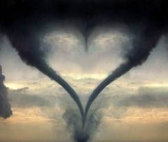
I opened the attached file. It contained the obviously Photoshopped picture you see here of two mirror-image, snaky-looking tornadoes with a funnel dividing the clouds between them, forming a heart. You can find the image without much trouble on the Internet, but I had never seen it before. As I looked at it, the snaky double-funnels I had seen yesterday popped into my mind. The similarity was weird–not that the previous day’s very real tornado resembled a heart; the only thing it looked like was scary as hell. No, it was the overall shape of its twin vortices and the way they had appeared in relation to each other that struck me.

Then it hit me. Brad didn’t have a clue where I was. He had no idea what I’d just been through. And he had never emailed me an image file before. Not only was the communication in itself unusual, but the timing of it was…well, it was incredible.

I could feel the tears coming to my eyes as the realization sank in. This email wasn’t from Brad. Not really. Brad was just a humble and available scribe; the message was from my Father, my wonderful heavenly Father. It was His way of saying, in a simple but powerful way, “Bob, I love you!”

What I’ve just written is something I believe with all my heart. God knows us through and through. He knows what makes you, you, and me, me; and He knows how to speak to each of us intimately, in ways that touch us in deep places if we have ears to hear. Here is what I believe He was saying to me:

“Bob, when you, Tom, Bill, Mike, and the rest of the guys were fleeing along that fenceline like scared rabbits, I saw you. I heard your prayer and the prayers of all who called on Me. And I was with you. My hand covered you and my presence protected you all–because I love you all, every last man of you who was there. Today, Bob, I’m letting you know that I truly was there–that yes, it was Me–and that I carry you in my heart.”

I am not one who calls every unusual thing that happens a miracle. I believe that genuine miracles are rare, and I dislike devaluing their reality by sloppily misapplying the word. But I also believe in grace, and from time to time I have witnessed extraordinary examples of what it can do. After receiving the email from Brad, I am convinced that what happened in the field on May 22 was one of those occasions. Things could easily have turned out far worse for those of us who were there. Instead of a joyous Christmas, this year could have been one of great sadness for our loved ones, and of an empty chair at the dinner table–a chair that once was ours. But this Christmas will not be that way. We will sit down once again with our families, and we will eat, and we will exchange gifts. We will get on with the rest of winter after the holidays. And we will return to the Great Plains this coming spring to enjoy another season of chasing the storms that we love.

Just about anything can be written off as coincidence, just as almost anything unusual can be written in as a direct act of God when it wasn’t necessarily so. It’s a matter of one’s worldview. If, having read my account, you’re inclined to consider my experience just a peculiar fluke, perhaps not even all that strange, then so be it. I can’t prove differently to you and I don’t feel that I need to try. But I most definitely believe otherwise, as does my friend Brad, and Tom, and Bill, and, I am sure, at least a few others who were there in the field.

It takes faith to see God’s kingdom, and faith is perhaps best described as an extra faculty, a sixth sense that augments the first five senses. It perceives and understands differently, and sees a different and higher reality behind the stuff of our lives. It is believing, but it is also a kind of knowing that I’ve never been able to describe satisfactorily. Like the color blue, once you’ve seen it, you know what it is; but whether you’ve experienced it or not, blue is blue, and so it is with the kingdom of heaven. However accurately or inaccurately, faith is the eye that sees it.

To my wonderful Lord, Brother, and Forever Friend, Jesus, whose birth I gratefully celebrate this season: Thank you–for so much more than I can begin to tell. And to my friends and fellow storm chasers, brothers and sisters of the skies, saints, sinners, seekers, wherever your worldview stands: May your Christmas be marked by grace. And may there be great steak and good beer in store for all of us this coming year.

Merry Christmas,

Bob

__________________

* You can see Adam’s clip along with more footage from the field, plus a whole lot more, on the DVD “Bullseye Bowdle,” produced by the lads at Convective Addiction. If you enjoy storm chasing videos, this one’s the real deal–and no, the guys haven’t paid me a solitary cent to plug it here.

No Second Season? Please Say It Ain’t So!

I’d been looking forward to the shift in weather with fall’s arrival, but now that autumn is officially here,  I dunno, boys and girls. I’m beginning to suspect that the mythical “second season” may not materialize for storm chasers this year–not in the Great Lakes, anyway. You folks out west will no doubt get your little romp, but up here in the tundra land of Michigan instability appears to be a thing of the past. I have to remind myself that it’s been only a week since one heck of a squall line blew through and caused extensive tree damage in my area. A couple of days later, though, as the system lifted out of the region, the moisture gave way to the relentlessly dry, crystal-blue skies of autumn, and I have the unsettling feeling that the die has been cast for the remainder of the year.

Today’s 4-8 day outlook from the SPC doesn’t make me feel any better about our immediate prospects:

 VALID 021200Z - 071200Z

   ...DISCUSSION...
   MODELS ARE IN GOOD AGREEMENT WITH THE PATTERN EVOLUTION THROUGH
   ABOUT SUN/D5 WITH LARGE TROUGH AMPLIFYING ACROSS THE GREAT LAKES AND
   ERN STATES AND AN UPPER RIDGE OVER THE ROCKIES. THIS PATTERN WILL
   RESULT IN A LACK OF INSTABILITY E OF THE ROCKIES WITH HIGH PRESSURE
   AT THE SURFACE. 

   WHILE THE TROUGH IS FORECAST TO LINGER IN SOME FORM OVER THE ERN
   CONUS...THERE IS MUCH DIFFERENCE ASSOCIATED WITH THE BREAKDOWN OF
   THE RIDGE AS A NEW TROUGH AFFECTS EITHER THE PACIFIC NW/GFS
   SOLUTION/ OR THE ENTIRE W COAST/ECMWF SOLUTION/.  REGARDLESS...THERE
   IS LITTLE CHANCE OF SEVERE WEATHER GIVEN MEAGER MOISTURE AND
   INSTABILITY.

   ..JEWELL.. 09/29/2010

“Lack of instability..little chance of severe weather…meager moisture…”–mmmph, doesn’t sound very promising, does it? I console myself with the thought that autumn has barely begun, and a nice fetch of moisture can still come chugging northward on the leading edge of some great dynamics to make life interesting. It happened as late as November 10, 2002, in Van Wert, Ohio. It happened just three years ago on October 18, 2007, across the Midwest, including here in Michigan. So my rule of thumb is, don’t pack away the laptop until the snows fly.

Still, as daytime temperatures retreat into the mid 60s and dewpoints drop to 50 degrees and below, it’s kind of hard to believe that the end of the parade isn’t long gone, and that last week’s wind event wasn’t just the cleanup crew. Good thing that this season’s “Storm Chasers” series will be airing soon and letting us all relive the glory days of 2010. After that, though…man, it sure is a long stretch from here to next March.

Review: “Bullseye Bowdle” DVD

It all came back to me yesterday evening, just as if I was once again sitting in the front seat of Mike Kovalchick’s Subaru Outback blasting east down US 12 in South Dakota. There it was–the Bowdle wedge, seething like a boiling, black cauldron in the field north of our vehicle.  Thanks to a beautifully produced new DVD, my buddies Tom, Bill, and I relived what was unquestionably our most unforgettable chase of the year.

To the guys at Convective Addition: Bravo, gentlemen! “Bullseye Bowdle” is a superb chronicle of the amazing May 22 north-central South Dakota cyclical supercell. From the first tornado of the day, to the massive, violent Bowdle wedge, to the infamous “farmer’s field” debacle, this video provides those who chased that day with an opportunity to relive its events, and those who didn’t with the chance to drool over what they missed.

I spotted our Michigan contingent–consisting of Bill and Tom Oosterbaan, Mike Kovalchick, and me–in a number of scenes. Hey, now we’re stars! Or just walk-ins, I suppose. Getting filmed on various chase videos that day seemed almost inevitable, since everyone out there was tracking the same slow-moving storm, albeit approaching it from different angles. “Bullseye Bowdle” does a splendid job of presenting multiple perspectives on each tornado.

The storm structure that day ranged from breathtaking to unbelievable, and this video captures it all, from storm initiation to the phenomenal, bell-shaped meso with an immense cone/quasi-wedge beneath it west of Bowdle, and plenty more. Of course, the powerful Bowdle EF-4 wedge is the show’s main act. But the graceful, highly photogenic tornado that formed northeast of Bowdle after the wedge dissipated is also spotlighted, and deservedly so. If you want to get a good look at multi-vorticity, check out the braided appearance of this tornado. During its truncated tube phase, it looks as if it were literally woven out of delicate, pirouetting vortices, like a strand of yarn in which you can see all the individual threads–simply amazing, not to mention quite beautiful.

And then, yes, there is the farmer’s field. Those of us who were there will never forget it: our narrow escape from disaster, and the craziness that followed. Having survived both the tornadoes and the ensuing lunacy, each one of us has a story to tell, and it’s nice to see part of that story dramatized on film. I love the footage of the drill-press tornado! But for me, the most jaw-dropping part is Adam Lucio’s segment of a tornado forming right by the vehicles, not more than 30 feet from one of them. I failed to witness that spectacle when we were actually sitting out there in the middle of the South Dakota prairie, but the video shows it clearly. It was a moment worthy of every expletive under the sun, or in this case, the mesocyclone.

My favorite comment in the video occurs as two sets of headlights appear on the horizon, heading toward us through the darkness. Adam Lucio: “Off in the distance we can see help is on the way.” Ha! Not quite. Swap out the “P” in “help” for a second “L” and that assessment would have been spot-on. I can’t make a blanket indictment of the locals since some of them were decent folks, sympathetic, and extremely helpful, and the land owner’s initial anger was understandable; but there were others who in my opinion behaved–how shall I put this? I’ll say it delicately–like wholesale, unmitigated, gold-gilded, rhinestone-encrusted, butt-drunken, power-abusing, 24-karat jerks.

Okay, I got that out of my system. Moving right along: The Convective Addiction crew have thoughtfully included a section featuring a time-lapse chronology of the storm as it busted the cap and began spitting out tornadoes. The value of this section, besides the fact that it’s just plain fun, lies in how the faster motion highlights aspects of the storm that I normally wouldn’t have noticed. It’s fascinating, for example, to watch the dramatic, cascading interaction between the flanged meso and an adjacent inflow band as the RFD carves a clear slot between them.

The video concludes with a well-presented synoptic and mesoscale overview of May 22, 2010 which does a good job of describing the setup. I don’t recall (and can’t check, not owning my own BlueRay player) whether it discussed the cap, which was the big forecasting question mark for that day. But the cap obviously blew, and the meteorological analysis does a good job of showing the ingredients which combined to make May 22 such a dramatic chase.

Besides some fantastic footage, Convective Addiction has also selected some tasty music for their sound track. However–and this is something I appreciate–they use the music judiciously, not to the point of overkill. In a chase video, I want to hear the reactions and interactions of the chasers; the sound of the wind, the rain, the passing traffic, and hail pelting the windshield; the real-life environmental stuff. That’s part of what puts me in the picture, and the storm chasers who produced this video clearly feel the same way. I know these guys like their jams, but in “Bullseye Bowdle” they wisely focus on the storm, the tornadoes, and the human element of the chase.

If I have any critique to offer, it would be that in their next video–and I hope there will be a next, and many more to follow–the editors of Convective Addiction might consider offering a brief wrap-up where appropriate in order to avoid the somewhat jarring effect when a video segment ends abruptly.

Bottom line: If you’re a storm chaser or just enjoy watching storm chasing videos, then “Bullseye Bowdle” is a must for your DVD collection. It’s available in both standard resolution and BlueRay at Convective Addiction.

——————–

For the sake of complying with new federal regulations, whether real or imagined: This review is not a paid review. I’ll gladly write reviews for pay. In this case, though, I bought the DVD with my own sweet shekels and I’m writing purely because I like “Bullseye Bowdle” and think you will too.