Review: “Bullseye Bowdle” DVD

It all came back to me yesterday evening, just as if I was once again sitting in the front seat of Mike Kovalchick’s Subaru Outback blasting east down US 12 in South Dakota. There it was–the Bowdle wedge, seething like a boiling, black cauldron in the field north of our vehicle.  Thanks to a beautifully produced new DVD, my buddies Tom, Bill, and I relived what was unquestionably our most unforgettable chase of the year.

To the guys at Convective Addition: Bravo, gentlemen! “Bullseye Bowdle” is a superb chronicle of the amazing May 22 north-central South Dakota cyclical supercell. From the first tornado of the day, to the massive, violent Bowdle wedge, to the infamous “farmer’s field” debacle, this video provides those who chased that day with an opportunity to relive its events, and those who didn’t with the chance to drool over what they missed.

I spotted our Michigan contingent–consisting of Bill and Tom Oosterbaan, Mike Kovalchick, and me–in a number of scenes. Hey, now we’re stars! Or just walk-ins, I suppose. Getting filmed on various chase videos that day seemed almost inevitable, since everyone out there was tracking the same slow-moving storm, albeit approaching it from different angles. “Bullseye Bowdle” does a splendid job of presenting multiple perspectives on each tornado.

The storm structure that day ranged from breathtaking to unbelievable, and this video captures it all, from storm initiation to the phenomenal, bell-shaped meso with an immense cone/quasi-wedge beneath it west of Bowdle, and plenty more. Of course, the powerful Bowdle EF-4 wedge is the show’s main act. But the graceful, highly photogenic tornado that formed northeast of Bowdle after the wedge dissipated is also spotlighted, and deservedly so. If you want to get a good look at multi-vorticity, check out the braided appearance of this tornado. During its truncated tube phase, it looks as if it were literally woven out of delicate, pirouetting vortices, like a strand of yarn in which you can see all the individual threads–simply amazing, not to mention quite beautiful.

And then, yes, there is the farmer’s field. Those of us who were there will never forget it: our narrow escape from disaster, and the craziness that followed. Having survived both the tornadoes and the ensuing lunacy, each one of us has a story to tell, and it’s nice to see part of that story dramatized on film. I love the footage of the drill-press tornado! But for me, the most jaw-dropping part is Adam Lucio’s segment of a tornado forming right by the vehicles, not more than 30 feet from one of them. I failed to witness that spectacle when we were actually sitting out there in the middle of the South Dakota prairie, but the video shows it clearly. It was a moment worthy of every expletive under the sun, or in this case, the mesocyclone.

My favorite comment in the video occurs as two sets of headlights appear on the horizon, heading toward us through the darkness. Adam Lucio: “Off in the distance we can see help is on the way.” Ha! Not quite. Swap out the “P” in “help” for a second “L” and that assessment would have been spot-on. I can’t make a blanket indictment of the locals since some of them were decent folks, sympathetic, and extremely helpful, and the land owner’s initial anger was understandable; but there were others who in my opinion behaved–how shall I put this? I’ll say it delicately–like wholesale, unmitigated, gold-gilded, rhinestone-encrusted, butt-drunken, power-abusing, 24-karat jerks.

Okay, I got that out of my system. Moving right along: The Convective Addiction crew have thoughtfully included a section featuring a time-lapse chronology of the storm as it busted the cap and began spitting out tornadoes. The value of this section, besides the fact that it’s just plain fun, lies in how the faster motion highlights aspects of the storm that I normally wouldn’t have noticed. It’s fascinating, for example, to watch the dramatic, cascading interaction between the flanged meso and an adjacent inflow band as the RFD carves a clear slot between them.

The video concludes with a well-presented synoptic and mesoscale overview of May 22, 2010 which does a good job of describing the setup. I don’t recall (and can’t check, not owning my own BlueRay player) whether it discussed the cap, which was the big forecasting question mark for that day. But the cap obviously blew, and the meteorological analysis does a good job of showing the ingredients which combined to make May 22 such a dramatic chase.

Besides some fantastic footage, Convective Addiction has also selected some tasty music for their sound track. However–and this is something I appreciate–they use the music judiciously, not to the point of overkill. In a chase video, I want to hear the reactions and interactions of the chasers; the sound of the wind, the rain, the passing traffic, and hail pelting the windshield; the real-life environmental stuff. That’s part of what puts me in the picture, and the storm chasers who produced this video clearly feel the same way. I know these guys like their jams, but in “Bullseye Bowdle” they wisely focus on the storm, the tornadoes, and the human element of the chase.

If I have any critique to offer, it would be that in their next video–and I hope there will be a next, and many more to follow–the editors of Convective Addiction might consider offering a brief wrap-up where appropriate in order to avoid the somewhat jarring effect when a video segment ends abruptly.

Bottom line: If you’re a storm chaser or just enjoy watching storm chasing videos, then “Bullseye Bowdle” is a must for your DVD collection. It’s available in both standard resolution and BlueRay at Convective Addiction.

——————–

For the sake of complying with new federal regulations, whether real or imagined: This review is not a paid review. I’ll gladly write reviews for pay. In this case, though, I bought the DVD with my own sweet shekels and I’m writing purely because I like “Bullseye Bowdle” and think you will too.
July 22 West Michigan Supercell and Lightning Fest

I haven’t seen a storm like last night’s storm in Michigan in a long, long time. Man, what a beauty!

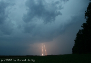
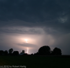
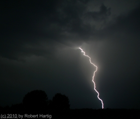
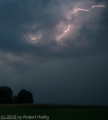
Non-stop lightning, much of it appearing to be positive strokes that lasted for seconds at a time, along with a veritable feast of anvil crawlers, made for a photographic smorgasbord. Plus, the storm structure–as much of it as I could make out at night, illuminated by the incessant lightning–was truly impressive. If only the storm had arrived an hour earlier, when there was enough light to really see the thing!

I had just finished doing a couple of interviews down in Dunlap, Indiana, for the book I’m writing on the 1965 Palm Sunday Tornadoes. My meetings

required me to forgo chasing a supercell that moved through the Battle Creek area as the warm front lifted northward, and I was curious to find out what had happened with it. Pulling into a parking lot, I fired up my computer, opened GR3, and gaped. A line of supercells was advancing across Lake Michigan from Wisconsin. The first one in the line looked great–SRV showed definite rotation–and, headed on an ESE trajectory, the storm was poised to make landfall around Saugatuck. Winds there were almost straight easterly, and they were beautifully backed across most of lower Michigan. Hmmm…what did the VAD wind profile look like at Grand Rapids? Dang, sweet! How the heck did that kind of setup wind up in Michigan?

The storms weren’t moving terribly fast, around 25 knots. Could I make it in time? I was bloody well going to try. There was no denying the rush of adrenaline now galvanizing me, thrusting me into chase mode. I hit US 20 and headed west past South Bend, where the highway merged into US 31 north.

I still had a good 40 miles to go by the time I connected with I-196 near Benton Harbor. I wasn’t sure whether I’d catch the storm by the time it made landfall. Maybe I’d be better off playing more to the east. But I decided to take my chances, and that turned out to be the right move. I couldn’t have timed it better.

As I approached M-89, the eastern part of the storm had made landfall, but the radar showed the rotation still out over Lake Michigan. It wouldn’t be there for long, though, and, having shifted its trajectory south of Douglas, it was now heading straight at me.

Bingo! This was exactly what I’d been hoping for. Leaving the Interstate, I headed east along M-89 and found a nice, open field a mile down the road, just west of 66th Street, 4 miles south of Douglas and 4 miles west of Fennville. Then, turning my car around to face the incoming storm, I parked and grabbed my camera out of the back seat.

The lightning in this beast requires superlatives to describe it. There seemed to be a never-ending supply of high-voltage CGs, delivered with the unbridled, over-the-top enthusiasm of a 4th of July fireworks finale and accompanied by the incessant grumbling of thunder. There were times, as the lightning cells moved past me and surrounded me, when I felt like I was sitting inside an immense flashbulb–a flashbulb that kept firing again, and again, and again. Oh, man, what an extravaganza of pure, searing power and beauty! I’ve done my best to capture it, but my skills as a lightning photographer fall far short of what this storm had to offer. Now, my buddy Kurt Hulst, he’s Da Man when it comes to getting fantastic lightning shots, and I know he got some last night. Me, I seem to have a problem getting a good, crisp focus at night, but I try.

By and by, the flickerings began to illuminate a cloud feature I’d been looking for: a hint of a beavertail off to my northwest. It’s location confirmed what the radar was telling me: the storm’s mesocyclone was moving straight at me. I was in a perfect location–and all this time, standing out in the field near my car, I had yet to feel so much as a drop of rain.

The mosquitoes were thick and nasty, and I was getting eaten alive, but viewing at my position was excellent. Farther east, I’d be getting into thick woods, and since the storm wasn’t exactly rocketing along, I stayed put until the meso got too close for me to be able to distinguish its features. Then I moseyed east a few miles.

I parked again for a few minutes at 63rd Street and noted that what had begun as a stubby beavertail had rapidly grown into an enormous inflow stinger. To my northwest, I could see what appeared to be a large, low wall cloud–hard to determine exactly what it was or what it was doing at night, but it looked convincing enough that I called it in to KGRR.

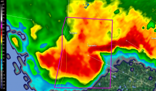
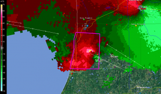
I tracked just ahead of this storm all the way to Plainwell. M-89 proved to be a perfect route, angling southeast along roughly the same path that the storm was taking. On the outskirts of Allegan, I stopped long enough to grab a few radar images. On this page, you can see a nice vault on the base reflectivity, and pronounced rotation on the storm relative velocity. (The circle just southeast of the town center marks my location. Ignore the marker with my name farther to the southwest on SRV; it’s old, an archive from when I dropped off of Spotter Network.)

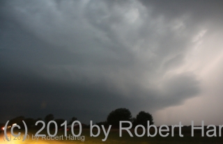
A little farther down the road, I pulled aside again where a large, open stretch afforded good viewing. The mesocyclone was clearly visible, with a formidable-looking flange on the north side, nice striations, and an impressive inflow band circling in overhead. I hung out at that location until the lightning drew too close for comfort, then hopped back into my car and continued east.

At Plainwell, I dropped south on US 131 past the Kalamazoo exit, caught M-43 west for a mile or so, then parked in a parking lot and let the storm’s southernmost edge blow past me. The storm was still tornado-warned, but the radar indicated that it was weakening–cloud tops lower, VIL not as robust. North of me, just on the other side of M-43, a sheet of rain cascaded out of the wind-blown darkness into the luminous orange domain of the street lamps. Within half a minute, it was upon me, and for a short while, I sat and enjoyed the blast of downdraft and deluge. The rain that I had managed to elude all night had finally caught up with me.

Finally, as the storm bowed out on its journey eastward, I drove back to US 131 and headed for home. I stopped again for a while at the Martin exit, long enough to see what would become of another supercell that was moving inland from the Lake. It, too, quickly bowed out, but, in keeping with the tone of the day, it lit the after-midnight sky with a bombardment of lightning.

It was good to finally pull into my parking lot, climb the stairs to my apartment, and step inside. It had been one heck of a day, and I was ready to call it a good one and hit the sack.

As nasty a storm as it was, why didn’t the Allegan County supercell drop tornadoes? The storm earlier in the afternoon had produced at least one tornado near the Battle Creek airport; why not this one too? After all, it and

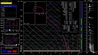
its compatriots had peppered Wisconsin with tornadoes prior to crossing the Lake and heading for West Michigan. All I can surmise is, CAPE was an issue. Winds certainly appeared favorable for tornadoes, and F5 mesoanalysis indicated 1 km helicities ranging from 150-250 across the area as late as 1:00 a.m. The RUC model sounding for KGRR maybe overdoes helicity, but it’s interesting to see what it says about instability. All I can think is that daytime CAPE–whatever it may have been; I never took the time to find out–petered out after sundown, and the shear alone wasn’t enough to spin up tornadoes. That’s my guess as a non-meteorologist, and I’m ready to get other insights and opinions from more knowledgeable heads than mine.

Whatever the case, last night’s was one heckuva storm, and the kind of chase I don’t get to enjoy too often in Michigan. It was nice to finally get such a great opportunity.