Year of the Cap Bust

I guess I’m just a slow learner when it comes to technical stuff that involves linear thinking. Sooner or later, though, if I stick with something long enough, I usually emerge more knowledgeable for having done so. Nowhere has this been more true than in storm chasing, an activity which obviously depends heavily on figuring out if and where there will be decent storms to chase.

Seems like I’m constantly being confronted with some new aspect of the atmosphere that I haven’t factored into my forecasting, or that I haven’t factored in as effectively as I needed to. The upside of that, though, is that I wouldn’t even be aware of what I don’t know if I hadn’t learned enough to at least recognize my areas of ignorance. If my forecasts aren’t as expert as those of a trained meteorologist, they’re nonetheless a seven-league bound beyond when I was just beginning to grapple with all those arcane terms and acronyms of convective weather such as SBCAPE, CIN, 0-6km bulk shear, LIs, helicity, and lapse rates, and when the only thing I could do with a skew-T or a hodograph was shake my head in bewilderment.

This has been the year of discovering the 700 mb/12C limit. By “discovering,” I mean through empirical experience, and by “empirical experience,” I mean cap busts. Of course, I’ve endured plenty of cap busts in my development as a storm chaser; I just didn’t understand exactly what was going on, or why the high risk area I was sitting in was producing nothing more than smug blue skies rather than carnivorous supercells.

One memorable day in Iowa drove home the lesson perfectly. MLCIN was supposed to erode by later in the afternoon, and it got to a point where it was eroding, at least according the RUC. With SBCAPE at some ridiculous figure like 7,000 j/kg, I figured that at some point a convective tower would punch through the cap and go absolutely gonzo. Instead, the clouds kept firing up into the nicely sheared environment and then dying, firing and dying, firing and dying. The reason? A 700 mb temperature of around 14C, possibly considerably higher. Lesson learned: it doesn’t much matter what the models have to say about the CIN eroding when you’ve got mid-level temperatures like that.

I experienced another cap bust yesterday, though I can’t feel too bad about it since I had no compelling reason to head out in the first place, the conditions were so marginal. It was interesting to notice that in this situation, the circumstances were reversed: RUC showing my area under very breakable 700 mb temps of around 10C, but with MLCIN creating some concern. However, the CIN appeared to be eroding, and when an SPC mesoscale discussion spotlighted the area I was in, I started feeling happy about having made the drive down to west-central Illinois.

But the CIN started building back in, and by 00Z I found myself socked in under values around -300 j/kg. Not much a parcel of air can do with that, I guess, no matter how big the CAPE is. I turned around and headed home.

A paper by Bunker, Wetencamp, and Schild of the NWS in Rapid City, South Dakota, explores the ins and outs of the 700 mb/12C limit and concludes that it has a limited, conditional application. However, as my buddy Mike Kovalchick pointed out to me, the paper also reveals that only 5 percent of tornadoes within the study period formed when H7 temps exceeded 12C, and virtually no violent (EF4 and EF5) tornadoes occurred above that threshold.

So for practical use in storm chasing, the 12C limit appears to be a very useful rule of thumb. The issue for me then becomes a matter of refining my ability to know when cold air advection will lower the 700 mb temps. But that’s a subject for another blog. I’m tired of thinking. It’s time to go meet my buddy Dewey down in Plainwell and grab a brew at Arie’s. Ciao!
Changes Coming to Stormhorn Blog

Greetings, friends and readers of Stormhorn.com!

I want to fill you in on some changes that are in the works for this blog. They’re not here yet, but they are impending, and I anticipate that they will help take the blog, and eventually its parent Stormhorn website, to the next level.

At the moment, the most significant change in the works is a brand-new, custom theme. My lady friend, Lisa, who is absolutely brilliant at website development, online marketing, and all things computer, has been beavering away steadily at the new version. When it is done, this blog will have a new look and much greater versatility. I’m excited about what Lisa has got planned, and I can’t wait to roll it out once it’s ready, see how you like it, and get your feedback.

Concurrent with the new theme, I’ve been thinking about adding an extra element of interest by featuring guest bloggers from time to time. They will be from the worlds of both music and storm chasing. I like the idea of offering you insights and perspectives besides just my own, and I hope that doing so will provide an added value for my readers as well as a positive experience for my contributors.

About my Jazz Improvisation E-BooK: While this project has been on the back burner for a while, I do anticipate picking it back up at some point. I’ve already got several installments written; however,  because I tend to be pretty thorough, each lesson takes me considerable time to develop, and with other more pressing matters to deal with, I just haven’t had time or focus for the e-book. Stay tuned, though, because it is by no means a dead project. As this blog and website continue to develop step by step, I will at some point get the e-book back on track.

So, there you have it: changes are coming to Stormhorn.com, and the first of them is right around the corner. Meanwhile, I’ll continue to post with the existing format, which has served me well thus far. I hope you’ve enjoyed your visits here, and that you’ll enjoy them even more as this blog enters an exciting new phase.

A Stormy Friday in Grand Rapids?

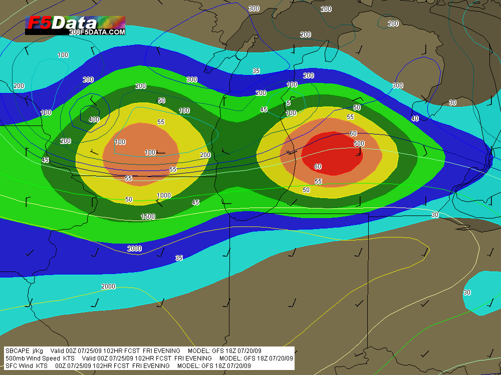
Out of idle curiosity, I ran the latest GFS and came up with the image below. The colored shading is 500 mb winds, and the contours are CAPE. Not shown: H7 temps of 4 C throughout Michigan, 50-60 kt bulk shear, and dewpoints in the mid-60s.

GFS for 00Z Friday evening, July 24.

GFS for 00Z Friday evening, July 24.

CAPE stinks, but I’ve got to love that jet streak parked right over Grand Rapids. Without decent convective energy, this setup is hard to get too hopped up about, but it’s certainly worth keeping an eye on. Probably a pipe dream in July, but in this part of the country you just never know.

Cool-Weather Wall Clouds

So there I was, driving down I-96 toward my mother and sister’s house in Grand Rapids this afternoon, when I saw what at first glance looked like a wall cloud. It looked like one at second glance, too, and third, hanging off of a cumulus tower in the distance.

Severe weather wasn’t in the outlook today, and in fact, the afternoon was coolish and not particularly moist, with spotty showers but no thunder or lightning. I was unaware of any reason to be on the lookout for abnormal weather, though the extent of the vertical development in the cumulus clouds coupled with their nicely sheared look would have been a tip-off under more propitious circumstances.

Anyway, I was intrigued by the cloud formation, but not quite prepared to call it anything more than a lowering at that point. It was falling apart over Grand Rapids by the time I turned north onto the East Beltline. But the show was far from over. Another large towering cumulus several miles to my northwest was exhibiting an even larger, blocky lowering which wasn’t showing any signs of dissipating.

That did it. It was time to get close enough to this thing to see just exactly what it was. This was a simple matter. The cloud was drifting quite slowly, and intercepting it involved nothing more elaborate than continuing north up the Beltline past 7 Mile Road, then pulling into a small turn-in, where I had an unobstructed view from maybe half a mile away.

The cloud was indeed a wall cloud. I could see a weak updraft dragging scud up into it, and even a hint of an RFD. More important, the cloud was circulating–very slowly, to be sure, but unmistakably. As it moved closer, I even observed a small, anticyclonic vortex spinning almost directly overhead. There was obviously enough shear and helicity in the atmosphere to create some interest, and I had a nice front-row seat. Just wish I’d had my camera with me, but as I said, I wasn’t expecting anything weatherwise today that would have made me think to grab it.

What I was seeing struck me as more fascinating than threatening, but I decided to call KGRR and report it anyway, just for the record. The met who took my information said he wasn’t surprised. He told me that the office had already received several reports of waterspouts out on Lake Michigan, plus other reports of funnel clouds. Sounded like a cold air funnel outbreak.

My buddy Kurt Hulst called later to tell me that he, too, had seen a wall cloud over Caledonia from where he lives in Kentwood. If I’d been home, it would have been a front door delivery, but of course I wasn’t. Seems to me, though, that Kurt said he got some photos. I hope so, because I’d like to see what I missed.

Days like today just go to show that the weather does what it wants, when it wants. Maybe the local WFO will offer an analysis of today’s conditions. That would be cool.

Lesson learned: take my camera with me wherever I go.

Midweek Severe Weather Potential for the Midwest

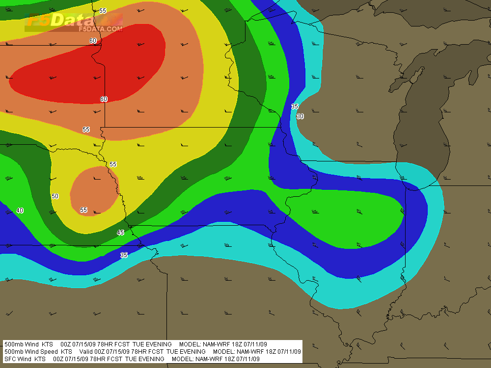
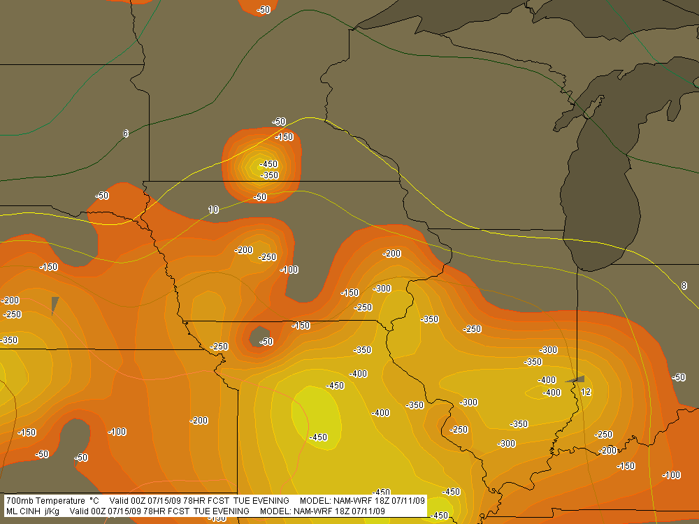
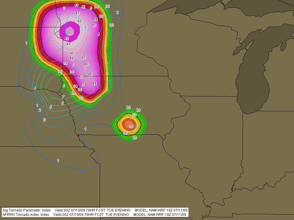
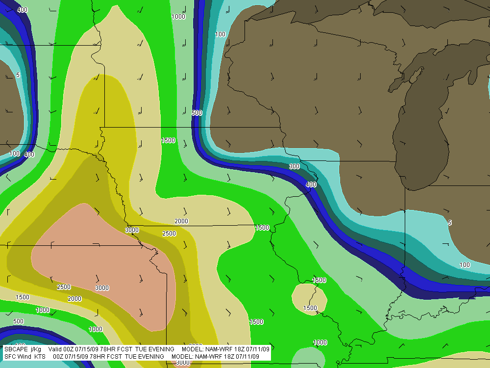
A significant weather event appears to be shaping up for the northern plains and cornbelt this coming Tuesday. For all you weather buffs and storm chasers, here are a few maps from the 18Z NAM-WRF run for 7 p.m. CT Tuesday night (technically, 00Z Wednesday), courtesy of F5 Data.

A couple items of note:

* The NAM-WRF is much less aggressive with capping than the GFS.  The dark green 700mb isotherm that stretches diagonally through central Minnesota marks the 6 C contour, and the yellow line to its south is the 8 C isotherm.

* The F5 Data proprietary APRWX Tornado Index shows a bullseye of 50, which is quite high (“Armageddon,” as F5 software creator Andy Revering puts it). The Significant Tornado Parameter is also pretty high, showing a  tiny bullseye of 8 in extreme northwest Iowa by the Missouri River.

Obviously, all this will change from run to run. For now, it’s enough to say that there may be a chase opportunity shaping up for Tuesday.

As for Wednesday, well, we’ll see. The 12Z GFS earlier today showed good CAPE moving into the southern Great Lakes, but the surface winds were from the west, suggesting the usual linear junk we’re so used to. We’ve still got a few days, though, and anything can happen in that time.

SBCAPE in excess of 3,000 j/kg with nicely backed surface winds throughout much of region.

SBCAPE in excess of 3,000 j/kg with nicely backed surface winds throughout much of region.

500mb winds with wind barbs.

500mb winds with wind barbs.

MLCINH (shaded) and 700mb temperatures (contours).

MLCINH (shaded) and 700mb temperatures (contours).

APRWX Tornado Index (shaded) and STP (contours). Note exceedingly high APRWX bullseye.

APRWX Tornado Index (shaded) and STP (contours). Note the exceedingly high APRWX bullseye.

Harlem.org: Jazz History at the Click of a Mouse

Last week, my lady Lisa sent me a link to a very cool website called harlem.org, which invites viewers to “explore jazz history through one photograph.”

Now, the photo in question, taken by Esquire camera man Art Kane, is one I had seen before, and is in fact quite famous. Featuring a veritable who’s who of jazz history, all gathered together on the steps and sidewalk outside an apartment in Harlem, the picture is utterly remarkable. Count Basie, Lester Young, Coleman Hawkins, Dizzie Gillespie, Marian McPartland, Milt Hinton, Mary Lou Williams, Thelonius Monk, Sonny Rollins, Maxine Sullivan, Stuff Smith, Oscar Pettiford…all there, along with many others, fifty-seven in all. The patriarchs and the young lions, side by side.

Still more amazing, however, is how harlem.org has utilized this photo to give you quick, biographical insights into everyone who appears in it. Just mouse over the photo to a general area of interest, click, and that section of the photo is enlarged. Now mouse one by one over the musicians in the enlargement and their names appear in a pop-up balloon. And here’s where it gets good: when you click on a particular musician, a larger window pops up containing a photo and information about him or her.

What I’ve described is just a thumbnail sketch of what the site has to offer. If you’re at all interested in the history of jazz, this website is a must. It’s worth visiting just to see the photo alone, but I promise you, you’ll find much more of value besides.

Of Camp and Cacti: Photos from 4th of July Week

Among the many interests that my sweetheart, Lisa, and I share is a love for photography. This last week we’ve poked around together in the outdoors with our Canon cameras and harvested a variety of images. So rather than write a lot of words, I thought I’d share a few photos with you. They’re about neither jazz nor storm chasing; they’re just odds and ends from nature and life at large.

Last weekend Lis and I headed up to Camp Henry, a Christian camp located on Kimball Lake north of Newaygo, to spend the Fourth of July with our close friend and dear sister in Christ, Kimberly Dunn. Kimber lives in Redding, California, but has been doing a summer internship here in Michigan at the camp. It was great to see her, and during our visit, Lisa and I naturally took a lot of photos.

Then yesterday, we went out on a photo expedition to capture prickly pear cacti in bloom. There is at least one species that is native to Michigan, the eastern prickly pear, Opuntia humifusa, also known as devil’s tongue. The blooming season for it is winding down, but there are still plenty of bright, butter-yellow blossoms available to fill a camera viewfinder.

With many photos to choose from, I’ve opted for images from nature and the outdoors, subjects that Lisa and I both gravitate toward more than anything else. I hope you enjoy the selection.

Sunset at Camp Henry

Sunset at Camp Henry

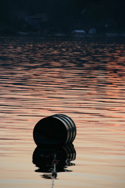
Swimming Buoy at Sunset, Camp Henry

Swimming Buoy at Sunset, Camp Henry

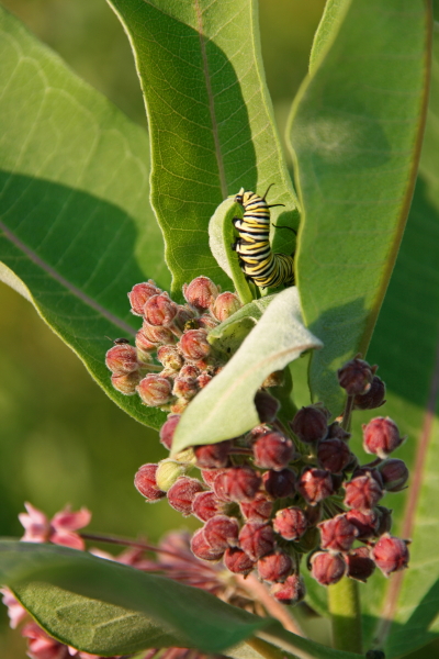
Monarch Butterfly Caterpillar on Milkweed

Monarch Butterfly Caterpillar on Milkweed

Loosestrife Flowers. These are a native species, not the highly destructive exotic, purple loosestrife, which takes over wetlands.

Loosestrife Flowers. These are a native species, not the highly destructive exotic, purple loosestrife, which takes over wetlands.

Eastern Prickly Pear

Eastern Prickly Pear

Also Known as Devil's Tongue

Also Known as Devil's Tongue

Opuntia Humifusa in Flower

Opuntia Humifusa in Flower

Playing Drums: Bet You Didn’t Know It Was This Easy

I’m visiting with my youngest brother, Brian, and his family in Dallas. Brian and I are the musical bookends among our siblings, Brian having earned his music degree at North Texas State University and gone on to make his living as a professional drummer. I haven’t yet shown him the following link. I’m sure he’ll feel stunned to know how easy playing the drums really is. Yes, stunned is no doubt the word. You don’t even need drums, not today in this age of quality technology. All you need is the miraculous keyboard featured in this video. If you’re playing rock and roll, just make sure to play the bass drum on da firs’ beat and on da turd beat.

Heaven help me and all other horn men if the guy in the video ever turns his eyes toward the saxophone. We’ll all be out of a job.

VORTEX 2 in Northwest Missouri

After years of planning and digging for research dollars, VORTEX 2 finally hit the pavement this spring, only to be met with a severe weather famine. It had to have been heartbreaking for the team, watching that merciless, unending ridge stretch from day to day and week to week, knowing that the clock was ticking on their window for gathering data.

Thankfully, tornadic storms hit the Plains before the window closed, and the team got what they needed. I wish it had gone as well for me. My tally for this season has been one tornado. But I did at least get the compensation of catching some nice storms with cool structure, including the June 7 supercell in northwest Missouri that every chaser in the country seemed to be after–including, of course, the VORTEX 2 armada.

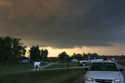
Just for kicks, here is a shot of one of the DOW trucks–the new one with the square radar rig. I believe I took this shot south of Forest City. The DOW is parked to the left in the photo, and I’m looking at it head-on. Viewed from that angle, the radar unit looks like the front end of a tractor trailer.

One of the DOW (Doppler On Wheels) trucks collecting data.

One of the DOW (Doppler On Wheels) trucks collecting data.

Sure does bring back memories. I hope I’ll get a chance to make a few more before the chase year closes. Prime storm season is over, but it’s still a long time yet before the snows fly.

Waking Up in Dallas

Morning. I’m still in bed, and from the next room, sounds of family are drifting through the door. I’m in Dallas with my sister Diane, visiting with my brother Brian, sister-in-law Cheryl, and little nephew Samuel. Since the last time I saw him, Sam has transitioned from babyhood to little-boyhood. He has acquired a vocabulary, a white baseball cap that it’s very important to wear (backwards or sideways, as is the custome), and a very cool train set that we played with last night.

My lady Lisa is holding down the fort back in Grand Rapids, where the weather is providing a much cooler contrast to the upper-90s heat that’s on the menu for this week here in north Texas. Chasing storms is of course out of the question. I’ve family to visit, a bit of work to do, and in any case, there are no storms. Summer has hit and the atmosphere is capped as tightly as an oil drum. On Stormtrack, chasers are bidding the 2009 chase season adieu. I note that the SPC has outlooked days 5-6, but they’re not using the kind of language that gets me very excited.

I’m keeping this short. I can hear the sound of forks clicking on breakfast plates. It’s time to shower up and get myself going.