April 10, 2011, Upper Midwest Chase Shaping Up

Tomorrow looks to be a big severe weather day in the upper Midwest and Great Lakes. It will also be my first storm chase of 2011, and with departure time less than 24 hours away, I’ve been scrutinizing the forecast maps, mainly the SREF and NAM.

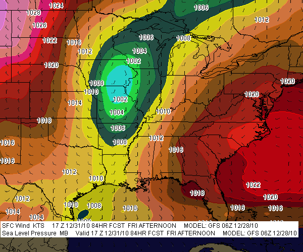
Whew! There are some formidable parameters coming into place for southeast Minnesota, northeast Iowa, much of Wisconsin, and northern Illinois. The SPC has outlooked this area for a moderate risk, with a mentioned of strong, long-lived tornadoes, and it’s not hard to see why. The one thing that bothers me is the marginally veered ambient surface winds overlaid by 500 mb winds from the southwest. Backing shows up way to the north in Wisconsin, in horrible territory for chasing.

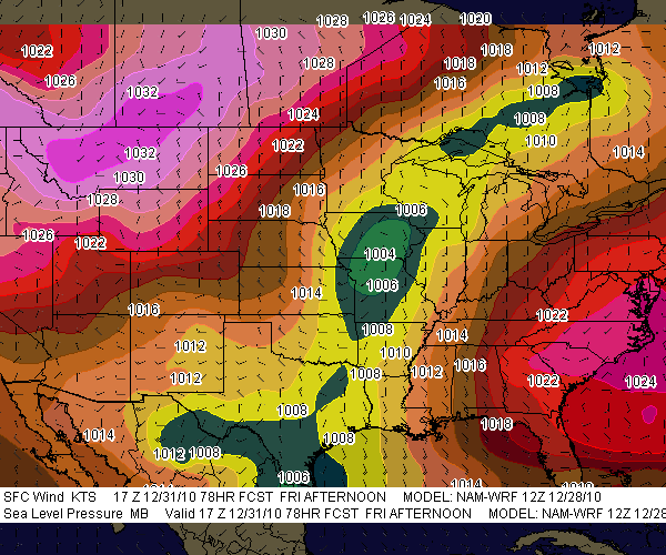
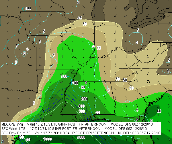
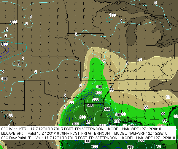
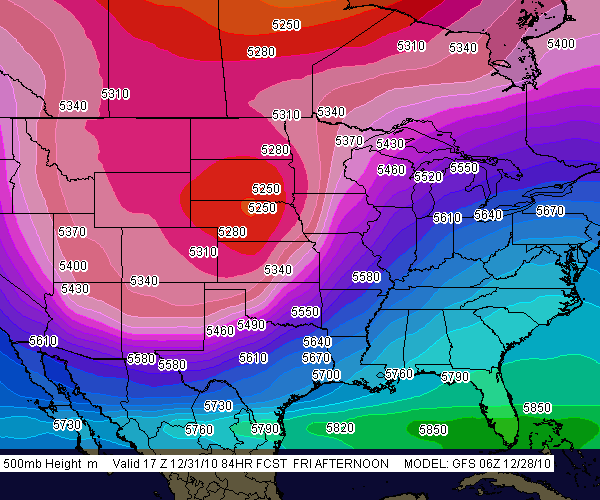
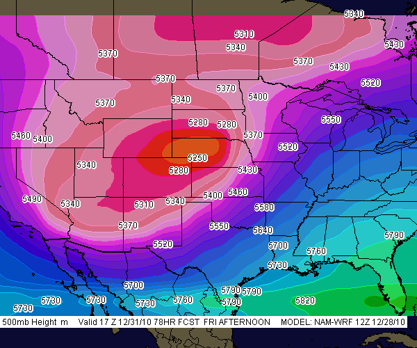
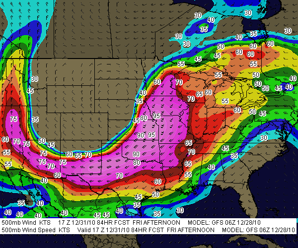
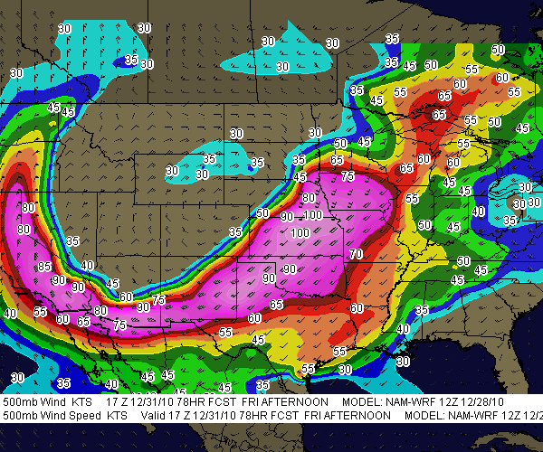
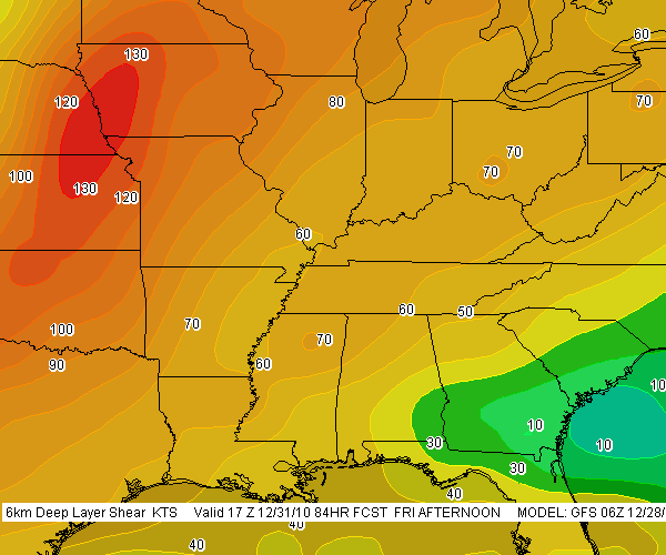
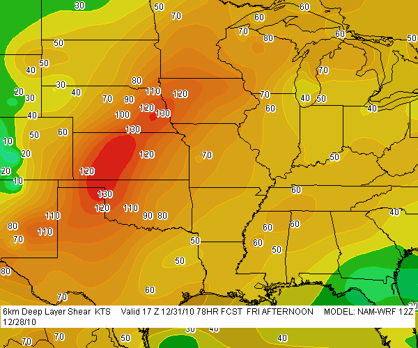
So my present choice for a target is Dubuque, Iowa. According to the NAM, the jet core is aimed in that direction. CINH wants to erode there, MLCAPE looks great, there’s a nearby 3 km MLCAPE max of 75 J/kg (forecast soundings may show better than that–haven’t looked yet), and…well, look down below at the maps I’ve been perusing and judge for yourself. There are a lot of them. In many cases, I’ve shown both 21Z and 00Z so you can see the progression of dynamics.

With height falls and vorticity moving in from the northwest, it may take a bit of will power not to get lured in that direction where the first storms will likely fire in Minnesota and start putting down tornadoes. They’ll be rocketing northeast along the warm front into rough territory, and patience will be the key to remaining in an area where the roads are decent and the prospects of seeing tornadoes instead of trees is better. I think our best play will be from northeast Iowa through northern Illinois. But I’ve got three other team mates with a vote, and I’m not the guy who’s driving. Plus, the best dynamics may have changed by tomorrow. This post just lays out what I’m seeing right now.

And now I give you the maps I’ve been looking at. Click on them to enlarge them. Please forgive the lack of organization. I added the 12Z F5 NAM maps to the gallery after I processed the others,  which makes for a lot of maps. I just don’t want to take the time to get them all in order. The SREF maps are no doubt already dated as I hit the publish button, and I think it’s important for me to keep the data as current as I can. I figure that if you’re savvy enough to make sense of these models, then you’re smart enough to know how to compare them!

Good luck and safe chasing to all of you who head out tomorrow.

A Stormy New Years Eve in the South?

slp-gfs-123110slp-nam-123110Could be. If the GFS is right, the chance of severe weather in the Gulf states looks good. The NAM too, having leaned in with its 12Z run, also points to the possibility of a New Years Eve episode down in Dixie Alley, though it wants to nudge the ingredients slightly to the west and north.

sfc-tds_mlcape-gfs-123110sfc-tds_mlcape-nam-123110So far the SPC appears to believe that severe weather is likely in the South on Friday, but while they’ve mentioned the T-word, tornadoes, they’ve been reluctant to say anything emphatically. Of course, we’re still four days out, and hitherto the forecast models evidently haven’t jibed (I haven’t followed the trends till now). But between this 500mb-heights-gfs-123110500mb-heights-nam-123110morning’s GFS and NAM, it looks like a pretty decent intrusion of moisture will lick inland from east Texas eastward to Florida, with 500 J/kg MLCAPE overlaid by ample shear as a large mid-level trough digs into the nation’s midsection. From the looks of things, Louisiana, Arkansas, and Mississippi could be in the crosshairs, and eventually, 500mb-winds-gfs-123110500mb-winds-nam-123110perhaps Alabama and the Florida panhandle.

Here are some GFS and NAM models for you to compare. Left-click on the thumbnails to enlarge them. I’ve used the model runs available to me at this writing on F5 Data–6Z for 6km-shear-gfs-1231106km-shear-nam-123110GFS and 12Z for NAM. The valid times should read 18Z, not 17Z.

.


Getting Set for a Backyard Chase

Last night’s bow echo certainly didn’t disappoint. I first spotted it in Wisconsin when it was a supercell putting down tornadoes near Milwaukee and thought, “That sucker is headed straight at us.” I watched as it hit Lake Michigan, maintaining rotation for a while but eventually morphing into a big bow echo. But what a bow echo! That northern book-end vortex really cranked as it moved inland and into the Kent County area. For a few scans of the radar, it looked like a small hurricane. Little wonder that it generated tornado warnings with a few reports of sightings by spotters and law enforcement.

But nasty a storm as it was, last night’s weather was probably just a prelude to what today, Wednesday, has in store. Veering surface winds taken into account, this could nevertheless be a tornado day for Michigan. The NAM shows a 70 knot 500 mb jet max blowing through the area, CAPE over 2,500, 70 degree dewpoints, and STPs to make a chaser happy.

Looks like it’ll be Kurt Hulst and me on this one. Bill is heading to Lansing to hang out with Ben Holcomb, and I think Mike Kovalchick is going to join them. That’s a good place to start. I’m not sure that I want to play quite so far east early in the game tomorrow, but I’m sure we’ll wind up well east of Lansing before the day is done. As of the 00Z run, it looks like the H5 will be nosing into West Michigan around 18Z, kissing an intensifying LLJ. Kurt and I had talked about setting up shop around I-96 and M-66. We’ll see what the 6Z run has to show us and play it from there.

At last, a Michigan chase with some real potential! And while I had guessed that storm motions would be in the neighborhood of 40 knots, the NAM decelerates them to a very manageable 25 knots. This could prove to be an interesting day, though I hope not a terribly impactful one. Southern Michigan has a lot of population centers, and I inevitably have mixed feelings whenever I see a big weather event shaping up for this area.

So Much for Thursday in Illinois

I was hoping, really hoping, that this Thursday would shape up as my first chase day of the year out in Illinois. The NAM sure looked promising for a second, but now, like Dante’s inferno, it has “Abandon all hope, ye who enter here” written over the door.

The GFS was never very positive to begin with, but at this time of year, Great Lakes chasers are optimistic out of sheer desperation, and I guess I wasn’t the only one who was rooting for the NAM with its bullish CAPE of up to 1,500 j/kg and sweet lapse rates.

But it’s gone, all gone. Yesterdays NAM runs weakened the CAPE and shuttled it south and east. A nice cold core setup in southeast Iowa/northwest Illinois materialized long enough to whisper sweet nothings, but nothings are probably all they were. The 500 mb low has since slunk apologetically back west toward Kansas City, with its -25 C temperature minimum well displaced from the surface moisture lobe. The setup could still change, but unless it bumps back east and stacks back up, I’m not going to drive that far to find out.

I will, however, very likely head toward the Michigan border around New Buffalo. Moisture looks to be ample with mid- to upper-50s dewpoints augmented by evaporation, backed surface winds, and precip breaking out by 21Z if this present NAM verifies. If it does, there could be a bit of lightning and thunder, and at least the slim possibility of a brief spin-up; if not, it’ll have been a pleasant break-in drive for chase season 2010.

Major Winter Storm Headed for the Great Lakes

We may not get socked with anything quite as bad as the three feet of snow that got dumped on Maryland a few days ago, but lower Michigan is poised for a major snow slam starting tomorrow morning. The current warning text from GRR reads as follows:

A WINTER STORM WARNING REMAINS IN EFFECT FROM 7 AM TUESDAY TO
1 PM EST WEDNESDAY.

HAZARDOUS WEATHER...

 * 6 TO 12 INCHES OF SNOW IS EXPECTED FROM DAYBREAK TUESDAY THROUGH
   WEDNESDAY MORNING.

 * THE HEAVIEST SNOW IS EXPECTED TOWARD THE INTERSTATE 94
   CORRIDOR WHERE 8 TO 12 INCHES OF SNOW IS EXPECTED. THE
   INTERSTATE 96 CORRIDOR WILL SEE 6 TO 10 INCHES OF SNOW...
   WHICH INCLUDES GRAND RAPIDS AND LANSING.

 * SNOW WILL BEGIN TUESDAY MORNING AND BECOME HEAVY FOR LATE
   TUESDAY AFTERNOON AND TUESDAY NIGHT.

 * BLOWING AND DRIFTING SNOW IS EXPECTED TUESDAY EVENING THROUGH
   THROUGH WEDNESDAY MORNING AS NORTH WINDS INCREASE TO 15 TO 25
   MPH.

no images were found

Here’s what the NAM-based F5 proprietary snowfall total shows for Wednesday at 18Z. (Click on the image to enlarge it.) The GFS moves things more to the south and probably is a bit more in line with the NWS forecast. But either way, tomorrow is going to be very different from the beautiful day we’ve had here today in West Michigan.

Well, what else can we expect? It’s early February, after all, and the groundhog probably was spot-on in his forecast for six more weeks of winter. I guess that explains why there’s open season on groundhogs in Michigan.

Major Winter Storm in Progress out East: Big Snow South of the Big Apple

no images were found

Which version of snowfall totals do you prefer–the NAM on the right, or the GFS, shown below? (Click images to enlarge.)

If you live out east, the question is purely academic. I doubt that you much care which forecast model is the more accurate, because either way, you’re going to be sitting under a ton of snow by tomorrow. That much is no secret. While the forecast models shown here are for 00Z Saturday night, the show has already started.

Farther down the page, you can see a level 2 radar grab from Sterling, VA, taken shortly after 10 p.m. It’s much prettier to look at than the picture

no images were found

that is unfolding over the nation’s capitol as I write in the form of heavy snow, freezing fog, mist, freezing rain, blustery winds, blizzard conditions–just about every kind of winter weather you can throw at one area in the space of a few miles as temperatures drift from below to above freezing.

The current Baltimore forecast for tonight and tomorrow reads as follows:

Tonight: Snow and areas of blowing snow. The snow could be heavy at times. Low around 29. Breezy, with a east wind between 16 and 23 mph, with gusts as high as 37 mph. Chance of precipitation is 100%. Total nighttime snow accumulation of 15 to 21 inches possible.

Saturday: Snow and areas of blowing snow. High near 29. Blustery, with a north wind between 18 and 22 mph, with gusts as high as 37 mph. Chance of precipitation is 100%. New snow accumulation of 4 to 8 inches possible.

no images were found

Ugh! For once I’ll take a Michigan winter forecast over what’s being served up elsewhere. Right now my friend Kathy out there in Greenbelt, MD, is getting her clock cleaned. It’s a good night for her and her boyfriend to eschew the Washington nightlife and hunker down inside. For that matter, I doubt there’s much happening in the way of a Washington nightlife on a night like tonight.

Meanwhile, down in the warm sector, much of eastern North Carolina is under a tornado watch. The radar shows a pretty grungy-looking, non-severe, low-topped squall line that doesn’t show much likelihood of putting out anything tornadic, but it nevertheless adds to the East Coast’s overall weather ambience.

Have fun out there, kiddies, those of you who live out east. As for me, I’m going to pour me a mugful of Bell’s Amber Ale and, for once, enjoy watching the snow not fall outside my window. Gloating over such things is permissible for lifelong natives of the Great Lakes.

Forecast Model Simulations for 1965 Palm Sunday Tornadoes: Part 2

The drive down to the WFO at State College, Pennsylvania, was well worth my while (see my previous post). Operational forecaster and research meteorologist David Beachler was a pleasure to work with–personable, patient, and eager to help me understand the exhaustive forecast simulations he had produced on the 1965 Palm Sunday Tornadoes. Having pored over the data with David, gaining his insights on its strengths and weaknesses, I am now extremely excited about what I’ve got on my hands.

David’s modeling uses the WRF-ARW 40 km. The resolution is too coarse to offer the fine details that the SPC is capable of producing, but it gives an excellent overall feel of what forecasters and storm chasers might see in the models if the Palm Sunday synoptic setup were to unfold today instead of forty-five years ago in 1965.

no images were found

There’s no way I can begin to cover all the material, which in any case I need to sift through in order to put together a reasonably concise and meaningful scenario. But I can at least give you a sample of some of the stuff I’ve got to work with. Click on the following images to enlarge them.

First, here is a hand analysis of the kind that is accessible to anyone through NOAA’s historical daily weather maps archives. Besides the surface map for April 11, 1965, you also get the previous day’s surface map, 500 mb chart, and other info. It’s what you would have encountered when you turned to the weather page in the newspaper that morning.

What you would never have seen–because parameters such as CAPE, CIN, helicity, and so on didn’t exist back then, and because even if they had existed, the forecast models which could have depicted them were still years down the road–is this map showing SBCAPE and low-level shear.

The map is for 2200Z, or 6 p.m. EST–roughly the time at which tornadoes began moving through northern Indiana.

It gets even better. Here is a model sounding for KGRR, also at 2200Z, using WRF-ARW Bufkit data. The skew-T and hodograph depict the conditions that were shaping up to produce the F4 Alpine Avenue tornado that formed

around 6:50 p.m., as well as other tornadoes in west and southwest Michigan that day. The helicity is impressive–and look at those winds! Forty knots at 850 millibars is no mere puff of air.

What really excites me is that, using RAOB’s cross-section feature, I should be able to reconstruct a vertical profile of the atmosphere for the entire outbreak area. I’m not sure how deeply I want to go with that, but I have the capacity.

Bear in mind that I’m just showing a couple of representative glimpses derived from a 00Z, day-one model initiation. In fact, David provided me with a range of initiation times that allows me to get a good sense of how the maps might have progressed from several days prior to the actual tornado outbreak.

In practical terms, the maps and model sounding data I’ve got correlate to the NAM. They’re not the NAM, but for storm chasers who typically work with the GFS, ECMWF, GEM, NAM, and RUC, what you see here is probably closest to what you’d find using the North American Mesoscale Model.

That’s all for now. This has been a time-consuming post, and at 2:30 in the afternoon, I need to pull away from it so I can bathe and eat. I didn’t arrive home until 3:00 a.m., so it’s time for this road warrior to reset his time clock and get on with the rest of life.

Friday’s Outlook: A Real October Leaf-Stripper

Whichever model gives the more accurate picture–the GFS or the WRF-NMM–one thing is sure: we Michiganians can say good-bye to the leaves. This Friday’s weather system promises to be a real October leaf-stripper, with a formidable low-pressure center deepening rapidly as it moves through Ontario.

The two forecast models continue to differ in timing, with the GFS moving the cold front rapidly through the state’s mid-section by 18Z, while the NAM plays it more conservatively and backs the surface winds considerably more. The NAM is also much more aggressive with 850 mb winds, with the 12Z run calling for 75 knots (!!!), while the GFS dribbles out a paltry 55-knot LLJ.

I have a hunch that the GFS is closer to the truth, though of course, time will tell.

Both models agree that instability will be non-existent. Not much there to gladden the heart of a storm chaser. But by golly, we’ll be seeing some wind. Bye-bye leaves!

For the sake of comparison, I took a sampler of 6Z model soundings for both the GFS and the NAM for Jackson, Michigan–a nice, central location that should offer a good compromise between both models. The differences are striking. Click on the images to enlarge them. For 21Z, I’ve shown only the NAM; by that time, the GFS has the winds lined out.

Forecast hours for Friday, October 30

15Z

GFS

NAM

18Z

GFS

NAM

21Z

NAM