August 20 Tornadoes in Canada

Yesterday’s storms marched across West Michigan pretty uneventfully, but as they moved east, they grew fangs. Moving into better helicity and shear, they began to develop supercellular characteristics from around Saginaw down into Ohio. It was interesting to track them on the radar, but I had no idea what was coming as they moved into Canada.

KDTX showed some small but nicely shaped and very suspect-looking cells moving out over Lake Huron. Evidently a few of them meant business. Tornadoes began dropping in Ontario, with the area around Toronto getting slammed, and with one fatality recorded in the town of Durham.

Here’s a video of the strong tornado that hit Vaughan, just north of Toronto. Looks like the person who posted on YouTube lifted the footage off of the news. I looked for other footage, but while there’s plenty out there, much of it isn’t of very good quality. This is some of the best I could find. There is presently one pretty dramatic, close-range clip of the Durham tornado which a young woman shot with the video cam on her cell phone, but I’m not confident that the link will last very long. Maybe this one won’t either, but I’m crossing my fingers and hoping it does.
The 2009 Storm Season: A Good One or a Bad One?

Reading a thread in Stormtrack, I came upon a comment in which the poster briefly griped about how the 2009 storm chasing season had been a lousy one for him. In the post that followed, another member mentioned that it wasn’t fair to blame the weather for one’s personal lack of scalps when the season itself had been pretty solid. The context was lighthearted, though I read enough pointedness to the second comment that it made me stop and think.

The first commenter never said there weren’t plenty of tornadoes; he just said that he’d had a lousy season. My own season hasn’t been that hot either. For the thousands of miles I’ve driven, I’ve only got one tornado to show for it–at least, one that I’m certain of. Sure, I’ve witnessed some beautiful structure and gotten beaned by some big hail in northwest Missouri, but this year has been nothing like 2008.

Am I blaming the weather? No. Those who were in a position to chase all the slight risk day in the Great Plains, from the southern plains to the Canadian border, had plenty of opportunities and did great. But me, I live in Michigan. Much as I’d like to be out there chasing slight risk days in Kansas, Nebraska, Colorado, and the Dakotas, logistically it’s just not feasible for me to do so. I’ve got a livelihood to earn, and gas and lodging cost money.

Add to that the fact that I made at least one poor judgment call that took me and my buddy south when we should have gone north, and I’ve had what amounts to a mediocre to poor storm chasing season. If I lived in the heart of Tornado Alley, I think I’d have enjoyed a much better one. But where I live, I have things to factor into my chase/don’t chase decisions that wouldn’t be as much of a concern if I lived in, say, Oklahoma City or Topeka, Kansas.

That’s not the weather’s fault. It’s just a matter of geography and personal circumstances. If I were to blame the weather for anything, it would be for putting in a substandard performance so far in the central Great Lakes, an area that never fares as well as the plains states to begin with. But of course, it’s pointless to blame the weather for anything, period. Weather isn’t an ethical entity–it just does what it does, and those of us who chase after it have to make our judgment calls the best we know how.

Living in Michigan, I’d be a fool to go after synoptic setups that I’d be an equal fool to pass up if I lived in Kansas instead. That’s the reality, at least for me, though I think I’m by no means alone.

So no, this hasn’t been a bad season for chase weather, not at all. But if you’re me, it hasn’t been a very good season for getting to much of the action.

Maybe the secondary season this fall will create a few more opportunities. I hope so. Give me another setup like October 18, 2007, and I’ll be a happy man.

Year of the Cap Bust

I guess I’m just a slow learner when it comes to technical stuff that involves linear thinking. Sooner or later, though, if I stick with something long enough, I usually emerge more knowledgeable for having done so. Nowhere has this been more true than in storm chasing, an activity which obviously depends heavily on figuring out if and where there will be decent storms to chase.

Seems like I’m constantly being confronted with some new aspect of the atmosphere that I haven’t factored into my forecasting, or that I haven’t factored in as effectively as I needed to. The upside of that, though, is that I wouldn’t even be aware of what I don’t know if I hadn’t learned enough to at least recognize my areas of ignorance. If my forecasts aren’t as expert as those of a trained meteorologist, they’re nonetheless a seven-league bound beyond when I was just beginning to grapple with all those arcane terms and acronyms of convective weather such as SBCAPE, CIN, 0-6km bulk shear, LIs, helicity, and lapse rates, and when the only thing I could do with a skew-T or a hodograph was shake my head in bewilderment.

This has been the year of discovering the 700 mb/12C limit. By “discovering,” I mean through empirical experience, and by “empirical experience,” I mean cap busts. Of course, I’ve endured plenty of cap busts in my development as a storm chaser; I just didn’t understand exactly what was going on, or why the high risk area I was sitting in was producing nothing more than smug blue skies rather than carnivorous supercells.

One memorable day in Iowa drove home the lesson perfectly. MLCIN was supposed to erode by later in the afternoon, and it got to a point where it was eroding, at least according the RUC. With SBCAPE at some ridiculous figure like 7,000 j/kg, I figured that at some point a convective tower would punch through the cap and go absolutely gonzo. Instead, the clouds kept firing up into the nicely sheared environment and then dying, firing and dying, firing and dying. The reason? A 700 mb temperature of around 14C, possibly considerably higher. Lesson learned: it doesn’t much matter what the models have to say about the CIN eroding when you’ve got mid-level temperatures like that.

I experienced another cap bust yesterday, though I can’t feel too bad about it since I had no compelling reason to head out in the first place, the conditions were so marginal. It was interesting to notice that in this situation, the circumstances were reversed: RUC showing my area under very breakable 700 mb temps of around 10C, but with MLCIN creating some concern. However, the CIN appeared to be eroding, and when an SPC mesoscale discussion spotlighted the area I was in, I started feeling happy about having made the drive down to west-central Illinois.

But the CIN started building back in, and by 00Z I found myself socked in under values around -300 j/kg. Not much a parcel of air can do with that, I guess, no matter how big the CAPE is. I turned around and headed home.

A paper by Bunker, Wetencamp, and Schild of the NWS in Rapid City, South Dakota, explores the ins and outs of the 700 mb/12C limit and concludes that it has a limited, conditional application. However, as my buddy Mike Kovalchick pointed out to me, the paper also reveals that only 5 percent of tornadoes within the study period formed when H7 temps exceeded 12C, and virtually no violent (EF4 and EF5) tornadoes occurred above that threshold.

So for practical use in storm chasing, the 12C limit appears to be a very useful rule of thumb. The issue for me then becomes a matter of refining my ability to know when cold air advection will lower the 700 mb temps. But that’s a subject for another blog. I’m tired of thinking. It’s time to go meet my buddy Dewey down in Plainwell and grab a brew at Arie’s. Ciao!

The Summer Pattern Is Setting In

The SPC has placed Michigan and the Great Lakes in a slight risk area for tomorrow. But tornadoes aren’t in the picture. The summer pattern appears to be setting in, with the jet stream moving its headquarters to the US/Canadian border. As far as Michigan is concerned, that’s close enough that we can still expect some decent kinematics here and there. But what we get tends to result in linear MCSs more than supercells and the like.

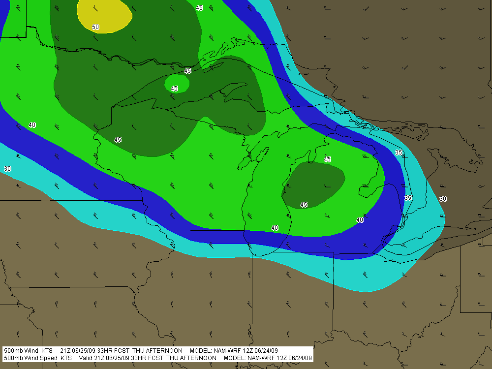
Tomorrow’s SBCAPE should settle in between 2,500 and 3,000 j/kg, with dewpoints in the 70s. That’s certainly an ample supply of convective fuel. And F5 Data shows this for H5 wind speeds at 21Z:

If you can live with northwest flow, that’s not bad. But of course, the underlying winds are all westerly. Once again, Michigan’s energy will get sabotaged by unidirectional winds. How pathetically par for the course! Maybe we’ll get some supercells, but we’re unlikely to see the low-level helicity needed to make them tornado producers. Probably better knock on wood when I say that, because the lake breeze zone can do some funny things with locally backed winds. Overall, though, I think the order of the day will be some nice, burly, ouflowish thunderstorms.

What do I know, though? I’m still pretty green as a forecaster, and I recall a couple years ago when the models showed a unidirectional setup with nothing in the way of helicities, and an F3 tornado ripped through Potterville.

One of the nice things about living in Michigan this time of year–among the many wonderful advantages of this beautiful state–is that we’re prone to get a couple supercellular events when the traditional Tornado Alley of the Great Plains simmers under a titanium cap. Those occasions aren’t anything you can count on, but it’s nice when they happen–for me and my fellow storm chasers, anyway. I suppose other folks here might see things a bit differently.

Blue Sky Bust in Iowa, But a New Chase Day in the Midwest

Thanks to a merciless cap, action in Iowa didn’t start yesterday until shortly before dark, and it never came close to living up to its potential. The RUC majorly underforecast convective inhibition, resulting in a lot of broken chasers’ hearts around Waterloo, mine included.

Storms finally did fire to the east, and a beautiful supercell crossed the Mississippi River after dark at Prairie du Chien, Wisconsin, where Bill and I have overnighted. We wound up on another cell that slowly organized and went supercellular, following in the first storm’s track. There were a number of storms in a cluster that showed rotation, but none of them put down tornadoes.

Today’s event looks to be widespread, and Michigan could very possibly see some action. But Bill and I are looking toward western Illinois. Galesburg presently looks good, or maybe Davenport. The storms are already getting their acts together. Time to sign off, check out of this hotel, and get on the road.

Heading for an Iowa Chase

As I write, I’m heading west down I-80 with my storm chasing buddy Bill Oosterbaan. Our target: Waterloo, Iowa. The 9Z RUC shows a nice convergence of 850 and 500 mb jets overspreading massive CAPE by 21Z, with a robust 200 mb jet nosing in. Progged surface winds could be better, but skew-Ts still show nice veering with height, and storm relative inflow is majorly backed.

Oh, yeah…and we’re looking at dewpoints of 75 degrees and higher, with dewpoint depressions around 5 degrees. LCLs should be so low we may have to tunnel underground to find the cloud bases.

The SPC has hatched out this area for tornadoes. No surprise. After a relatively modest season, we may be on the verge of a significant outbreak. It’s a bit sobering to think that Parkersburg, Iowa, could get slammed again. I expect we’ll see a PDS statement at some point today, and I wonder whether the outlook won’t get bumped from a moderate risk to a high risk as well.

Tomorrow also looks to be a hugely active day, and the latest SREF places a sigtor in Michigan. So stay tuned. I’m sure there will be more to come.

June 7 Northwest Missouri Supercell

Now that I’ve had a chance to rest up and catch up after Sunday’s chase in northwest Missouri, it’s time to do a writeup. I’ll summarize by saying that there were no tornadoes, but there was some great structure along with hail the size and disposition of wild boars.

My plan was to hook up with Bill, Kurt, and Tom, who had headed west a day ahead of me in anticipation of chaseworthy storms. Unfortunately, a stout cap quashed an otherwise potent setup, and the guys–along with lots of other storm chasers–endured a blue sky bust. Like I told Bill, they needed me out there with them to erode the lid for them.

I left around 10:00 Saturday night and drove as far as Davenport, Iowa, where I overnighted. The next day, I hightailed it for Topeka, Kansas. Bad route choices delayed my arrival, and storms had already initiated by the time I got within the vicinity. But that actually simplified my choice. Rather than heading into Kansas, I worked my way north of Saint Joseph, Missouri, along I-29, then hit the backroads to intercept a supercell that was making its way across the border near Rulo, Kansas.

Parking my car outside of Big Lake, Missouri, I set up shop and got some nice photos as the storm moved in. The base was lowering and developing a rotating wall cloud. Here is what the storm looked like when I took my first shot.

Wall Cloud at Big Lake, Missouri, June 7, 2009

Wall cloud at Big Lake, Missouri, June 7, 2009.

The cloud was southwest of me and moving eastward, which meant that I could expect plenty of rain and probably a good clobbering by hail. In a little while, sure enough, golfballs began to fall all around me. No rain, just sizeable hail. The cloud at this point was directly to my south and looked like this:

Wall cloud passing to the south.

Wall cloud passing to the south.

It was time to vamoose, and none too soon. The advance guard of a veritable armada of storm chasers was driving by. I pulled in behind the DOW (Doppler On Wheels) and other Vortex 2 vehicles and followed them toward Forest City. By the time I reached SR111 and began heading south, I had pulled ahead of the circulation. I wanted a few photos of the wall cloud advancing directly toward me, so I found a place to pull aside. Opening the car door, I stepped out into some ripping inflow and snapped a few shots.

Wall cloud approaching SR 111 north of Forest City.

Wall cloud approaching SR 111 north of Forest City.

I missed the really big, gorilla hail that some chasers encounterd, but the occasional baseball size was big enough for me. Somehow I escaped getting hit by the larger chunks, though one of them hit my roof squarely with a loud whack. I still haven’t checked to see whether there’s a dent.

Eventually I caught up with the guys at the I-29 overpass, where a zillion other chasers were also parked. Seems like everybody and his dog’s first cousin was on this storm. If I ever get rich enough to purchase a dedicated chasemobile, it won’t be an SUV or a TIV-style monstrosity. It’ll be a concession van with a fold-out bar.

Anyway, Bill, Tom, and Kurt forged ahead and I followed them for a ways, but eventually opted for a more southern route when they headed north toward Union Star. I figured they’d be hitting heavy precip and probably some nasty hail, and I wanted to stay on the south edge of the updraft, which was heading east by southeast. Here are a couple photos from what was, from my vantage point, one of the more promising episodes in the life of the storm.

Wall cloud with clear slot wrapping in.

Wall cloud with clear slot wrapping in.

Possible funnel cloud trying to develop.

Possible funnel cloud trying to develop.

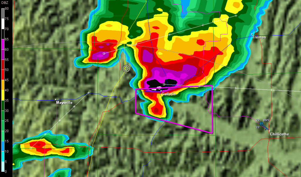
I believe the above shots were taken near Amity. From there, I headed east through Maysville and Weatherby, and across I-35 to just west of Altamont. There, I decided to end the chase and start heading home. The storm at that point was heading into Gallatin and was showing one of the best reflectivity echoes of its career on GR3.

Base reflectivity showing tornado-warned storm approaching Gallatin.

Base reflectivity showing tornado-warned storm approaching Gallatin.

But darkness was closing in, and I had no desire to chase this storm at night through the hinterlands of northwest Missouri. At that point, I was thinking about overnighting in Des Moines, and I had miles to go before I slept.

Tribute to a Storm Chasing Partner

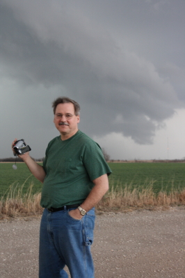
Wild Bill Oosterbaan, Chase Partner Extraordinaire

Wild Bill Oosterbaan, Chase Partner Extraordinaire

I contemplated cropping the above image to achieve a better visual balance. Then I thought, nah. For one thing, what’s the point of trying to balance the photo of a character who’s as wildly off kilter as Bill. For another, and all kidding aside, I’d have to trim out a good portion of the storm clouds. And that would be like trimming out the very essence of Bill Oosterbaan. You see, clouds like those are Bill’s passion. They’re what first brought us together thirteen years ago, and they’ve been propelling us across the miles ever since in search of convective mayhem.

Bill is my chase partner. Of course, I chase with some other great friends and storm chasers as well, but Bill…well, I’ve just covered more miles with him by far, paid more dues, experienced more busted chases, learned more about weather, and yes, seen more tornadoes and beautiful storms, than with anyone else. This post is my tribute to my fellow chaser, comrade in convection, and good friend of over a decade.

Bill and I are very different temperaments. Conduct a Meyers-Briggs personality profile of each of us and your first conclusion probably wouldn’t be that we ought to get in a car together and travel 1,000-plus miles at a stretch in search of intense, potentially lethal weather. But we’ve survived both the storms and each other, and learned quite a bit in the process. And, I might add, we’ve had a heckuva lot of fun.

I first met Bill back in 1996. That was the year I also conducted my first successful storm chase right here in Michigan. I had already done a chase or two with Bill and his brother, Tom, but on that sticky August day, the two of them were out on the golf course. So when a supercell fired up and formed a wall cloud right outside the window where I worked, I drove solo across the Kent and Ionia County countryside and scored a slim, elegant tube tornado north of Saint Johns.

On my chases since then, though, I’ve rarely been without Bill. So our development as storm chasers has followed a very similar track. I saw my first Great Plains tornado with Bill. In 2005 we chased the record-breaking Six State Supercell together from west of Columbia, Missouri, all the way back to Michigan. On two separate occasions, we’ve witnessed nighttime tornadoes strike large towns. Our technology has advanced from a miniature TV and stop-offs at airports  and libraries in order to access radar data, to laptops equipped with all the tools known and loved by storm chasers today. We’ve even figured out how to use most of the stuff. Our forecasting skills have grown from those early days of trying to decode the arcane language of SPC discussions, to making our own forecasts with increasing success.

Lately my laptop of four years has been giving me fits. This is  nothing new, but it has gotten to the point where I’ve finally ordered a new one from Dell. It’s a heavy-duty toughbook that’s made to take punishment, perfect for the road. Bill sees  in it the end of an era. He says he’s going to miss watching my eyes bulge and the veins pop out in my neck. I hate to deprive him of such a simple pleasure; it’s a small thing, and it causes him so much joy. On the other hand, I think he’ll agree that there’s a lot to be said for having a computer that doesn’t crash when we need it most. Typically that happens while we’re in pursuit of some rain-wrapped meso with who knows what lurking in its interior.

I look forward to tracking down plenty more mesos with my friend and long-time chase partner. Many more storms, countless more hours on the road, and yes, more arguments with the ornery cuss. Because the storms are what it’s about for both of us, and I think we’ve learned–and will continue to learn–plenty from each other about chasing them. Our respect for one another is mutual, as is our love for the wild, untamed beauty of Big Weather. When Bill and I talk, it’s mainly about storms. We never get bored. For us, talking about the weather is far from trivial conversation. There’s always something new to learn, something fresh to discover.

That’s why I refuse to trim those storm clouds out of the picture up above. To lessen their presence would be to lessen the story they tell about the man standing in front of them. They’re a vital part of Bill. So let the clouds remain and let the picture look a bit unbalanced. After all, Bill’s a storm chaser. What kind of balance do you expect out of a guy who hunts tornadoes?

Bill, mi amigo, it sure has been a blast. Here’s to you. Here’s to shared experiences, to the thousands of miles we’ve driven, and to the thousands we’ve yet to drive. Here’s to the the Lord who has kept us safe and blessed us with success.

And, as always, here’s to the storms.

Chicken Soup for the Solo

The meds that the doc prescribed for me seem to finally be working their mojo. I’m still coughing, but it’s no longer a painful cough, and yesterday’s feverishness has passed. Today I went out and bought a bunch of Amish chicken and a whole passel of assorted veggies and rice, and I made up a huge potful of chicken soup. I’ve heard more than one person tell me that the old wive’s tale is true: homemade chicken soup has a wholesome, curative property. I believe it. People breathing their last gasp have been known to revive at a mere whiff of my chicken soup.

Anyway, it’s been a week since I’ve played my horn, and in the interrim, I’ve felt so lousy that I haven’t even thought about it. As for storm chasing, ha. Good thing I didn’t go down to Tornado Alley last weekend with Bill and Tom–not only would I have been miserable, but by now they would be, too.

Storms have been lighting up the Plains pretty much all week. My friend Kurt Hulst was out in Oklahoma yesterday with his pal Nick, and he posted some nice pics on his blog. I’m assuming he caught the supercells in northern Texas earlier today as well. Can’t wait to see those photos.

Of course, I’ve been out of the action. Out of practice on my sax, out of the picture for chasing storms. In another couple of days, though, I should be ready to rumble. I just hope the weather feels the same way. My head is finally back on my shoulders only barely enough that I might start giving a rip about the forecast models, and maybe even be able to make some sense out of them again.

Enough for now. Tornadoes can wait. Right now, a bowlful of chicken soup is calling my name. If I eat enough, I might find myself in good enough shape by tomorrow to blow a few notes on my saxophone. Chicken soup for the solo. I like that idea.

The Tornado Fest That Wasn’t

Now that Sunday’s brouhaha in Tornado Alley is over and done, the big question seems to be, where were all the tornadoes? The turnout was there, the fans were waiting, but besides the rope and the wedge/multivortex/stovepipe that my buddies Bill and Tom witnessed near Crawford, Oklahoma, in company with a multitude of other chasers, there just wasn’t anything to make postcards out of. The big show never showed. Even the lone supercell that wandered north out of Texas into Oklahoma’s higher helicities never produced, despite its lack of competition. Oh, there were a couple of twisters in Kansas, and with a tally of four, Iowa had the most reports of all. Ironically,  it wasn’t even in the PDS high risk area.

This is by no means to criticize the crew at the SPC; those are some highly adept meteorological minds, the finest in the world. No, it’s just to muse at the vagaries of the weather. Rudimentary as my own forecasting skills are, I’ve nevertheless come to realize that no matter how good a forecaster one becomes, the weather is still the weather. Capricious. Subject to subtleties that no one gives weight to until after the fact. The butterfly beats its wings and a tornado fires up in Texas–or a seemingly volatile setup falls apart.

Judging from the YouTube videos and the photos posted on Stormtrack, a lot of people managed to be in the right place at the right time for the one storm in Oklahoma that did produce a couple very photogenic tornadoes. But the event was a far cry from high-risk mayhem.

Guess I can’t feel bad about that, since I was sitting at home nursing a chest cold while my mates were out there roaming the Plains. The cold now seems finally poised to start breaking up, and hopefully in another day or two I’ll feel halfway human again. It’s just as well that I get this nonsense out of the way now, so I’m up to snuff physically in a couple weeks when my buds and I head out to the Alley for an extended tour. I hope that by then, there won’t be any lack of the right ingredients in the atmospheric brew to make the trip worthwhile.