Storm Chasing for TV 8: Taking It to the Next Level

I met this afternoon with WOOD TV 8 meteorologists Kyle Underwood and Matt Kirkwood to discuss chasing storms for TV 8. I’m excited about the prospect of taking what has hitherto been a longstanding hobby of mine, albeit one of passionate focus, and upgrading it to the semi-professional level.

When Ben Holcomb left Michigan last year for the grand storm chaser’s Mecca of Oklahoma, he offered to hook up several of his Troll compatriots with TV 8 to fill his vacancy. One of those chasers was me. At the time, gracious as Ben’s offer was, I nevertheless felt I had to decline due to a pathetic lack of equipment. But the thought of the opportunity kept nagging at me, so I finally decided to take a chance and purchase some stuff I really can’t afford out of the sense that I can’t afford NOT to do so. My gut instinct, which I hope is right, is that my investment will pay for itself over the storm season. Thus, motivated by the possibility of having my avocation become self-sustaining, with tax writeoffs on mileage and expenses as an added incentive, I dropped a healthy chunk of cash on the following items:

  • ♦ Panasonic HDC-TM700 video camera with 32 gig internal memory
  • ♦ 32 gig HDSC memory card
  • ♦ Logitech Pro 9000 webcam for live streaming video

The cash outlay is not one I take lightly at a time when my money is tight. It’s a good barometer of how seriously I take storm chasing. But after speaking with Kyle, I’m impressed that WOOD TV appears, on its part, to be equally serious about developing a topnotch crew of local chasers. Commitment matched with commitment is a good thing.

Besides my purchase of equipment, over the past few weeks I’ve also invested a good amount of my time and a bit more cash studying for my HAM radio test, which I took and passed last Friday. Today I finally found my new call letters in the FCC list, so I’m now officially good to go as a HAM operator.

Additionally, per Lisa’s recommendation, I’ve registered with Vimeo, and after giving it an introductory look-over, I feel good about that resource as an online video repository. Vimeo should allow me to start embedding my footage in future Stormhorn.com blog posts, and it may also serve as an easy way to make my material accessible to WOOD TV.

All that now remains to be done is to sign up with Chaser TV and start getting familiar with the live streaming video. That and familiarize myself with Vimeo and its capabilities. I’ve got a bit of a learning curve ahead of me between now and April 1, when WOOD TV hopes to begin tapping into its chaser pool.

Since all the chasers in that pool know each other–it’s a small, connected community, as I’m sure storm chasers anywhere will understand–there’s the potential for some decent synergy on a chase day. What one man misses, another is likely to catch.

So…a new experience lies ahead for 2011. No way am I missing big weather when it shapes up out west in Tornado Alley. But if statistics mean anything, this year’s La Nina could bring a bonanza of severe weather closer to home, even to my back door of West Michigan. When it does, I’ll be on it, dashcam streaming and camcorder a-blazin’.
The Cap Won

I don’t know why so many storm chasers decided to chase in northern Missouri this last Monday. I could have told folks it had “cap bust” written all over it–didn’t fool me for a minute, as you can see by reading my post written the day before.

Ahem…right, so I got snookered too. The GFS was spot on about the cap, and the NAM way underforecast it. As a result, Missouri chasers wound up sitting under relentlessly empty skies waiting for convection to fire. It finally did in northeast Kansas–after dark. Storms ignited along a boundary (the warm front? ) and a couple went supercellular and even tornado-warned for a heartbeat before the cap re-exerted itself and squenched them.

The real action, ironically, took place in central Illinois and Indiana, well east of where most folks–including me–had expected. Supercells cut a swath along the warm front through Terre Haute, Indianopolis, and parts east and southeast into Kentucky, and a number of purple boxes lit up the radar screen. Nevertheless, SPC storm reports list only one confirmed tornado that touched down near Hillsboro, Illinois, northeast of Saint Louis.

Them’s the breaks. I didn’t chase that day, and I’m glad that I didn’t because I’d almost certainly have gotten skunked in Missouri when I could have driven straight south down US 41 to Terre Haute, not even having to mess with Chicago traffic, and waltzed on into the sweet zone.

Ah, well. I chased today–if chasing is what you can call a guaranteed grunge fest–down toward a warm front by the Michigan border. The trip was my compensation prize for not heading out when it really counted these past few days. The SPC had outlooked a five percent tornado risk this afternoon, and supercells were making their way northeast across Illinois toward Indiana. I figured that if they held together, I might catch them, but not surprisingly, they mushed out.

That was okay. I was chasing blind, with no radar and few expectations other than the hope that I’d at least see some lightning. I did, and called it good. The main storm season is still on the way, and there’s no need to fret over spilled milk when the cow is just priming its udder. It won’t be long now.

Countdown to March

It’s the last day of January. Just one month to go till storm season begins! Yeah, baby!

I’m not the only one who thinks this way. A lot of you fellow storm chasers get happy at the thought of March arriving. It won’t be much longer–just four little weeks. Then spring begins.

That’s right, spring. While the vernal equinox will occur on March 20 at 2:35 a.m. EST this year, marking the arrival of astronomical spring, March 1 is the beginning of meteorological spring. Yes, boys and girls, there really is such a thing.

The Roman calendar began the year and the spring season on the first of March, with each season occupying three months. In 1780 the Societas Meteorologica Palatina, an early international organization for meteorology, defined seasons as groupings of three whole months. Ever since, professional meteorologists all over the world have used this definition.[5] So, in meteorology for the Northern hemisphere: spring begins on 1 March, summer on 1 June, autumn on 1 September, and winter on 1 December.

–From “Season,” Wikipedia

The long and short of it is, even as middle-tier states from the Texas panhandle eastward are dealing with the aftermath of an ugly winter storm, spring is just around the corner. On Tuesday, Groundhog Day, we’ll get the authoritative word from Punxatawney Phil on what the next six weeks holds in store weatherwise. But whatever his verdict may be, the fact is, we’re two-thirds of the way through meteorological winter. We’re almost there!

So dust off your laptop. Spring will be here before you know it.

Storms Next Week: Is There Hope?

I love this balmy, blue fall weather. But down inside me, not too far from the surface, convective starvation is gnawing away. Does 2009 have a “second season” in store? Judging by this year’s insipid, ridge-robbed primary storm season, there’s reason to wonder, but I sure hope so.

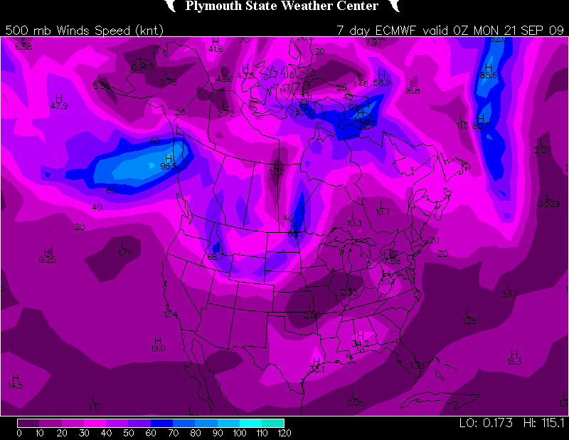
There may be a flicker of hope for a week from now, at least if you go by the ECMWF.

090914162010

ECMWF 500 mb winds for Sunday night.

As for the GFS…mmmph.  More zonal flow, though the sea level pressure map suggests a hint of troughing for the northern CONUS. Not anything to pique one’s interest, though. And here’s the SPC’s 4-8 day outlook:

VALID 171200Z - 221200Z

   ...DISCUSSION...
   GENERALLY BENIGN CONDITIONS -- WITH RESPECT TO THE POTENTIAL FOR A
   SUBSTANTIAL SEVERE EVENT -- ARE FORECAST THROUGH DAY 5-6 /I.E. FRI.
   AND SAT. SEPT. 18-19/...AFTER WHICH SOME FAIRLY SUBSTANTIAL MODEL
   DIFFERENCES BECOME APPARENT BETWEEN THE GFS AND ECMWF.  THOUGH SOME
   HINTS THAT SEVERE POTENTIAL COULD INCREASE FROM DAY 6
   ONWARD...CONFIDENCE REMAINS QUITE LOW ATTM.  UNTIL THEN...SEVERE
   POTENTIAL APPEARS LIMITED AT BEST...AS SLOWLY PROGRESSIVE PATTERN
   ALOFT KEEPS THE MUCH OF THE U.S. UNDER THE INFLUENCE OF LONGWAVE
   MEAN RIDGING.  GIVEN THE LACK OF APPRECIABLE SEVERE POTENTIAL DURING
   THE FIRST HALF OF THE PERIOD...AND LACK OF CONFIDENCE IN MODEL
   GUIDANCE BEYOND...NO SEVERE THREAT AREAS WILL BE HIGHLIGHTED THIS
   FORECAST.

I’m rooting for the Euro. It sure would be nice to see some storms. Any kind of storms. Just some decent lightning would be much appreciated right about now.

As I’ve said more than once this year, I’m crossing my fingers but I’m sure not holding my breath.

VORTEX 2 in Northwest Missouri

After years of planning and digging for research dollars, VORTEX 2 finally hit the pavement this spring, only to be met with a severe weather famine. It had to have been heartbreaking for the team, watching that merciless, unending ridge stretch from day to day and week to week, knowing that the clock was ticking on their window for gathering data.

Thankfully, tornadic storms hit the Plains before the window closed, and the team got what they needed. I wish it had gone as well for me. My tally for this season has been one tornado. But I did at least get the compensation of catching some nice storms with cool structure, including the June 7 supercell in northwest Missouri that every chaser in the country seemed to be after–including, of course, the VORTEX 2 armada.

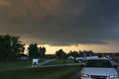
Just for kicks, here is a shot of one of the DOW trucks–the new one with the square radar rig. I believe I took this shot south of Forest City. The DOW is parked to the left in the photo, and I’m looking at it head-on. Viewed from that angle, the radar unit looks like the front end of a tractor trailer.

One of the DOW (Doppler On Wheels) trucks collecting data.

One of the DOW (Doppler On Wheels) trucks collecting data.

Sure does bring back memories. I hope I’ll get a chance to make a few more before the chase year closes. Prime storm season is over, but it’s still a long time yet before the snows fly.