The Groundhog Day Blizzard of 2011

blizzard3-2011The cloud tops are up to 20,000 feet here in Caledonia, and about two minutes ago the first impressively bright flash of lightning lit the blizzard swirling around my apartment. Thundersnow! Rare, but  not unexpected tonight, and now that it has arrived, I’m continuing to see sporadic flickers of lightning. That initial one was a doozy, though, and all I can think is, Cool! How often does one get to hear thunder rumble through the teeth of a February blizzard?

Man, is it blowing out there!

All eyes have been on this winter storm for the past several days, watching it move from forecast models into reality. Nowcloud-tops-2011here it is, and it is a humdinger. Anywhere from a minimum of 12 up to 16 inches of snow is predicted to dump on our area, and south of us it only gets worse. Pink is the color that indicates heavy snowfall on my radar color table, and I don’t recall ever seeing such a large expanse of it covering my screen before. Between now and sometime tomorrow morning is when the heaviest snowfall is supposed to occur, and looking outside my window at the maelstrom swirling dimly out of the midnight sky, I see nothing to contradict that prognosis.

blizzard4-2011Ah! Another flash of lightning and another rumble of thunder! This is nice. Imagine that–me, an avowed snow grinch, enjoying a blizzard! But I have to say, this storm appears to be living up to all expectations. I honestly don’t recall that I’ve ever experienced thundersnow before, so I’m really pleased to be getting such a novel form of entertainment.

The three fairly recent radar grabs and the water vapor image on this page will give you an idea of what a truly wild evening this is. Click on the images to enlarge them. The first and third are basic winter reflectively images, with the latter offering a more zoomed-in look at southern Michigan. Look at all that pink! Interrogating a few of the deeper hues has given me reads of nearly 40 Dbz, and that’s nothing compared to elsewhere, and perhaps to what yet lies in store for us.

blizzard-2011-wvAs for the second screen, that shows cloud tops. The teal colored blobs indicate tops of 20,000 feet or greater, where thundersnow is likeliest to occur. And the fourth image depicting water vapor gives a macro view of what the entire system looks like as an immense entity sweeping eastward, with the dry slot punching upward into Illinois.

This may be one for the history books. I’m glad I stocked up on groceries, because I doubt I’ll be venturing out tomorrow. I doubt anyone will be. I’m certain that all the schools will be closed, and quite possibly many businesses as well. It will be a good day to hunker down and feel grateful for being indoors.

Zang! Another bright flash. I just got a phone call from my friend Brad Dawson, who lives down near Gun Lake. He tells me that a big towerblizzard6-2011500 feet from his house is getting continually struck. That has to be an experience, and from the looks of things, it’s apt to be one that continues through the night. Lacking any similar tall objects here, the lightning isn’t as constant, but it continues to flicker, and the storm itself is intensifying. What the heck–here’s one last image: a current radar scan. I just got a reading of 43.5 Dbz in one of the darker blobs of pink!

This is one howler of a winter storm system. But I’m done watching it for now. It’ll still be here in the morning. Time for me to hit the sack and enjoy the light show for a while before I fade out. Good night!
First Day of Meteorological Winter

Some of you will greet the news with glee, others with a groan, but either way, today is the first day of meteorological winter. Right, we’ve still got another three weeks before the winter solstice, when the year’s shortest period between sunrise and sunset marks the arrival of astronomical winter in the northern hemisphere. But it sure looks like winter right now to me, and that’s what matters to meteorologists. For them, winter begins December 1, just as each of the other three seasons commences on the first day of its three-month block. Why? Because that arrangement corresponds better with how we experience seasonal weather in real life. Here in Michigan, we often get a pretty good hammering of snow in November, and by winter solstice on December 21 (or sometimes 22), we’re already usually pretty well socked in. It seems almost laughable when someone announces on solstice that it’s the first day of winter. Really? Could’a fooled us. We thought it began a month ago.

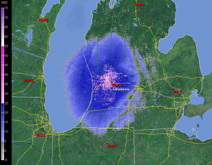
I woke up this morning to be greeted, very appropriately, by the year’s first snow accumulation. Yesterday temperatures opened in the low fifties, but they began dropping and the afternoon grew downright chilly. Today snow is falling, and out in the parking lot a woman is brushing the white stuff off of her car. It’s almost like winter has been consulting its watch, waiting in the wings and then entering the stage exactly on cue with a bucketload of lake effect. The snow will be with us for a few days, now, and the radar will continue to look a lot like the image on this page. Click on it to enlarge it, and get used to it, because you’ll be seeing a lot of similar pictures from now until meteorological spring arrives on March 1, 2011.

Michigan in the Crosshairs Today?

Most of the time when I chase storms in Michigan, it’s as a wannabe sitting in my armchair gazing wistfully at my radar as I follow the action out west. Every once in a while, though, I get something right here in my own state that’s worth hopping into my car and driving after with my laptop and camera at hand and hope in my heart.

Today is shaping up to be such a day. It’s about time. June is upon us, and that means the peak tornado season has finally arrived for Michigan. Frankly, that term, “peak tornado season,” strikes me as glaring overkill when it comes to Michigan. But we usually have a few incidents every year, and today could be one of them. Perusing the last couple of NAM runs, including the 00Z, and running a few model RAOB soundings, I’m casting my eyes on the Flint-Pontiac area, where surface winds appear to remain, if not backed, at least southerly at 00Z tomorrow evening.

With dewpoints at or exceeding 65 degrees below a warm front draped across central Michigan, straight westerly mid- and upper-level winds with 45-50 knots at 500 mbs, and forecast SBCAPE upwards of 2,000 J/kg, there certainly look to be some decent ingredients in the vat. Insolation will be either the eye of newt that either makes the magic happen tomorrow or the missing ingredient that quashes instability thanks to blowoff from storms farther west.

no images were found

Attached are a couple soundings, the first for 23Z at Flint and the other for 00Z at Pontiac. Not bad-looking hodographs, particularly for Michigan. As you can see, the surface winds are southerly. Farther west, they veer to the southwest, though they by no means create a unidirectional scenario. Interestingly, while the STP and Stensrud Tornado Risk indices spotlight the area around Flint, F5 Data’s APRWX tornado index bullseyes Grand Rapids down toward Kalamazoo. Maybe that’s because a 500 mb jet max noses into this area by 00Z.

no images were found

Traditionalist that I am, I prefer backed, or at least southerly, surface winds if I can get them.  So as of the 00Z run, I’m eyeballing parts east, probably up around Flint near the warm front. The morning run may tell a different story. I just hope it’ll be a positive one.

Here’s to sunny skies, decent CAPE, and a good, productive backyard chase!

ADDENDUM: I wrote the above last night. The morning picture changes things a bit. Specifically, the satellite shows a nasty batch of CAPE-killing clouds blowing into the area from an MCS out west. That’s bad news. However, the clouds show some clearing expanding in their midst. That’s good news. Moreover, Mike Kovalchick sent me an HRRR model radar image showing a supercell popping up in mid-Michigan at 22Z. I’m sure that’s dependent on decent CAPE, which presumes enough clearing for good afternoon heating.

This latest info is good to have, but it doesn’t change my game plan, which is to wait and see what happens by the afternoon.

August 20 Tornadoes in Canada

Yesterday’s storms marched across West Michigan pretty uneventfully, but as they moved east, they grew fangs. Moving into better helicity and shear, they began to develop supercellular characteristics from around Saginaw down into Ohio. It was interesting to track them on the radar, but I had no idea what was coming as they moved into Canada.

KDTX showed some small but nicely shaped and very suspect-looking cells moving out over Lake Huron. Evidently a few of them meant business. Tornadoes began dropping in Ontario, with the area around Toronto getting slammed, and with one fatality recorded in the town of Durham.

Here’s a video of the strong tornado that hit Vaughan, just north of Toronto. Looks like the person who posted on YouTube lifted the footage off of the news. I looked for other footage, but while there’s plenty out there, much of it isn’t of very good quality. This is some of the best I could find. There is presently one pretty dramatic, close-range clip of the Durham tornado which a young woman shot with the video cam on her cell phone, but I’m not confident that the link will last very long. Maybe this one won’t either, but I’m crossing my fingers and hoping it does.

VORTEX 2 in Northwest Missouri

After years of planning and digging for research dollars, VORTEX 2 finally hit the pavement this spring, only to be met with a severe weather famine. It had to have been heartbreaking for the team, watching that merciless, unending ridge stretch from day to day and week to week, knowing that the clock was ticking on their window for gathering data.

Thankfully, tornadic storms hit the Plains before the window closed, and the team got what they needed. I wish it had gone as well for me. My tally for this season has been one tornado. But I did at least get the compensation of catching some nice storms with cool structure, including the June 7 supercell in northwest Missouri that every chaser in the country seemed to be after–including, of course, the VORTEX 2 armada.

Just for kicks, here is a shot of one of the DOW trucks–the new one with the square radar rig. I believe I took this shot south of Forest City. The DOW is parked to the left in the photo, and I’m looking at it head-on. Viewed from that angle, the radar unit looks like the front end of a tractor trailer.

One of the DOW (Doppler On Wheels) trucks collecting data.

One of the DOW (Doppler On Wheels) trucks collecting data.

Sure does bring back memories. I hope I’ll get a chance to make a few more before the chase year closes. Prime storm season is over, but it’s still a long time yet before the snows fly.

June 19 Central Illinois and Indiana Storm Chase

Approaching our storm from the north near Normal, Illinois.

Approaching the storm of the day south of Normal, Illinois.

After Iowa’s blue-sky bust on June 18, yesterday provided some welcome and much-needed activity. Between illness and May’s ridge of steel, my chase expeditions this year have been limited. The Edina, Missouri, tornado of May 13 has been my only tornado to date for 2009. Yesterday did nothing to improve that statistic, but it did offer a vigorous, classic supercell with some great structure that ensured my 1,650-mile, two-day chase with my buddy Bill Oosterbaan wasn’t a complete washout.

For that matter, storms did finally fire in eastern Iowa, and while Bill and I were too late to catch the big mutha that slammed Prairie du Chien (Ben Holcomb, if you happen to read this, great job on tracking that beast into the hills and jungles of Wisconsin!), we did manage to latch onto the one that followed in its footsteps. But I’m no fan of night time chasing and neither is Bill, and knowing the kind of topography that lay to our east once we crossed the river, we dropped our chase at Prairie du Chien and found ourselves a hotel.

After a decent breakfast yesterday morning, we were on the road by noon and headed south. The SPC showed a moderate risk for a large area extending from Iowa and Missouri east across the corn belt and Great Lakes. With a continuation of yesterday’s huge CAPE and good bulk shear, a widespread severe weather outbreak seemed like a sure bet. However, veering surface winds and unidirectional flow seemed to put the kibosh on chances for tornadoes in all but a few areas to the east, where helicities improved, particularly around 21Z.

As we approached Davenport, Iowa, heading south, we could see towers muscling up along an east-west boundary that transected Illinois south of the I-80 corridor. Catching I-80 east, we could see new cells firing up farther to the south on GR3. With a Kankakee target in the back of our minds, we decided to drop toward Normal on I-39.

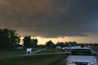
By the time we drew near the town, the northernmost storm was showing rotation on the radar. The tower was just to our west, and as we proceeded down the highway, the updraft base came into view, dominated by a well-developed wall cloud.

Wall cloud on northernmost storm.

Wall cloud on northernmost storm.

We headed for an intercept, tracking with the storm until it began to degrade. Meanwhile, another cell to the south was strengthening and beginning to exhibit distinct rotation on SRV, so with the storm we were on mushing out, we abandoned it in favor of the second, rapidly intensifying supercell.

One heckuva hail shaft or what?

One heckuva hail shaft or what?

This bad boy had an impressive hail shaft, if hail is what we were actually seeing. Maybe it was just plain old rain with a bit of hail mixed in. The reason I wonder is because of the paucity of hail reports. We got tapped a bit as we closed in, but mostly we just encountered buckets of rain. Whatever the case, the updraft tower with the sunlit precip column was a beautiful sight.

Second storm showing hail shaft and updraft tower.

Second storm showing sunlit precip core and updraft tower.

After working our way south of the storm’s rear flank, we proceeded east and finally gained some good, clear views of the business end. Tracking with it from near Urbana through Homer, Fairmount, and Westville toward the Indiana border, we were in a good position to enjoy the structure as the storm went through several cycles.

Rotating wall cloud.

Rotating wall cloud.

Just east of Homer, the wall cloud tightened and I could see rapidly circulating cloud tags descending toward the ground. We pulled over to watch. The rotation wasn’t far away–maybe a quarter of a mile–and it appeared to be moving toward us. This was strange as we were southwest of the wall cloud, but you can’t argue with a developing tornado. With the updraft approaching to within a couple hundred yards of us, Bill seemed intent on analyzing why the storm was acting so peculiarly, while I favored beating a hasty retreat and working out the behavioral aspects of storm circulation from a somewhat greater distance. Storm chasing sure has its interesting moments.

No tornado materialized, the storm headed east, and we continued on with it. I noticed a couple of tornado reports from around Fairmount and Westville, but while I suppose it’s possible that there was a brief spinup or two, Bill and I never saw an actual tornado. We did witness a few times when the wall cloud began to torque  pretty intensely, and I sure wouldn’t have wanted to be directly below it.

The whitish wall cloud is half a mile from us and rotating vigorously.

The whitish wall cloud is half a mile from us and rotating vigorously.

Possibly a funnel cloud at this point.

Possibly a funnel cloud at this point.

But from the time we first intercepted it to the point where it finally began to fizzle 120 miles later west of Crawfordsville, Indiana, the storm was outflow-dominant. Never once did we enounter surface inflow, though above ground level, I’m sure inflow was strong. In Bill’s words, the circulation kept reaching toward the ground, looking for something to grab onto, but it never could manage to root and produce a tornado. If we’d had backing winds…if the helicities had been there…I’m sure the storm would have been a potent tornado breeder. It never got its act together in that regard, but I doubt the communities in its path felt terribly disappointed, and from my perspective, the storm provided an interesting chase with some very nice moments.

Last gasp: wall cloud at US 41 west of Crawfordsville, Indiana, shortly before the storm began to collapse.

Last gasp: wall cloud at US 41 west of Crawfordsville, Indiana, shortly before the storm began to collapse.

For sheer structure, the “Danville supercell” was interesting and photogenic, with some nice RFD slots wrapping in, and, toward the end of the storm’s career, with a classic, stack-of-plates mesocyclone that was as nice as anything I’ve ever seen. (Sorry, no photos–the ones I have didn’t turn out well.)

One downside to this chase–and it is a big one–is that somewhere between Homer and US 41, I lost my camcorder. It wasn’t a pricey camcorder; it was a used Sony that I bought from my friend and fellow storm chaser Kurt Hulst. But it has done me good service over the past year, and I hate to think that it is presently sitting out there by the side of some Illinois backroad. What’s even worse is, my video of this chase is in it.

The drive back to Grand Rapids was a long one. I arrived at my apartment around 2:30 a.m. and collapsed. The chase was fun and I think I needed it, but it’s good to be back home with the love of my life, Lisa, whose bright eyes and beautiful smile warm my heart wherever I travel.

Remembering the Parkersburg/Hazleton Tornadoes

One year ago today, the second EF5 tornado in the history of the new Enhanced Fujita Scale rating system descended on Parkersburg, Iowa, and obliterated the southern third of the town. I and fellow storm chasers Bill and Tom Oosterbaan and Jason Harris could see the intense rotation moving over Parkersburg on GR3 as we stairstepped southeast from the northern edge of the cell, heading for an intercept. There’s a certain sense of disbelief when you see something like that, a feeling of, Naah, it can’t be as bad as it looks.

But it was. A few miles farther down the road, with the rotation still at least ten miles to our west, debris–some of it fairly large–began to fall from the sky. That was when we knew for sure. Something terrible had happened. Even with pieces of sheet metal clanging down onto the pavement in front of us, I had a hard time believing that a tornado disaster had just occurred, but I think we all felt a certain sober awareness that a community had been hit.

We intercepted the storm near Fairbank, where the NWS indicates that the Parkersburg tornado occluded. Parking on a sideroad, we watched as a large, new wall cloud formed and moved directly toward us. Warning an Amish family who was standing in their yard, watching, to take shelter, we scooted south and then east, watching as the wall cloud lowered and kicked up a ton of dust. A second, enormous tornado had formed, barely discernible through the haze. We tracked with it to the east as it headed on a collision course for Hazleton, mercifully grazing the southern edge of that town. Had it hit head-on, I suspect that the Hazleton tornado’s EF3 rating would have been higher.

It’s hard to believe that a whole year has passed since that event and the several days of Great Plains action that preceded it. What a difference between then and now, with a nasty ridge casting a pall on this May’s peak chase season.

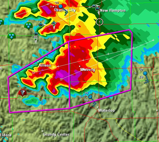
In remembrance of the Parkersburg/Hazleton tornadoes, I’m including a couple visuals. The first is a radar grab of the supercell as it moved out of Parkersburg. The tornado icon is a storm report from the town, just minutes old. You can see our GPS position marked by a circle with a dot in the middle of it on the northeast edge of the storm

The Parkersburg, Iowa, tornadic supercell.

The Parkersburg, Iowa, tornadic supercell.

The second is this YouTube link to my video of the Hazleton tornado. My videography may not be the best in the world, but I think you’ll get a sense of the intensity this storm evoked. It was my first really big tornado, and it was close.

I doubt this year has anything in store for us  like what we saw that day. But who knows? I’m not ready to write off this chase season yet–though I certainly hope it doesn’t hold a catastrophe like the Parkersburg tornado.

Wedging into Tornado Season

Bill called to say that he and the crew just saw a wedge out there in western Oklahoma. The LSR gives the town of Crawford, near the Texas panhandle border, as the location.

Good for the lads–and the lass, as I understand there’s a new female member of the crew. As for me, sitting here in my La-Z-Boy sofa, nursing a chest cold and watching the radar, naturally I feel like shooting myself through the head. A wedge on a PDS day–and the show is just getting started. And I’m not there! AAAAAHHHHHH!!!!!!!

If there’s any consolation, it’s knowing that I’ve been able to make myself useful doing a little nowcasting. And it sounds like the team got some cool footage. Can’t wait to see it.

Mostly, though, I can’t wait to kick whatever is causing this blasted chest congestion and get out to take some video of my own. Tornado season 2009 is underway!

Shifting gears, last night’s gig at One Trick Pony with Francesca and Friends was a blast, even if I was feeling under the weather. Wright McCargar and I had a discussion about the impact of musicians on each other’s playing. In my experience, one bad musician can drag a whole group of good musicians down; and, conversely, one great musician can kick good players up to the next level. There’s nothing like being with really good musicians, and Francesca and her rhythm section are exactly that.

Moving back to storm chasing, it’s time for me to publish this post and then check out the radar. The storms bumping off of the dryline look to be going tornadic, and I’m thinkin’ that my buddies will have their hands full for the next five or six hours. Sure wish I was with them. But GR2AE ought to keep me entertained; maybe I can capture a few radar grabs to correspond with the photos that I’m sure will be coming back from out west.

Moderate Risk in West Oklahoma and Texas

My buddies Bill and Tom Oosterbaan and Derek Mohr are heading for today’s sweet zone out in western Oklahoma. The Storm Prediction Center has placed the area under a moderate risk, with an indication of strong tornadoes. No doubt. With CAPE exceeding 2,000 and decent helicity and upper-level support increasing by 0Z, all the ingredients will be there. I’d imagine the guys will be playing the triple point per the SPC, where helicity will be maximized. Should be quite the caravan out there today. A person with a popcorn truck and GR3 could make a killing on a chase day.

Farther north, back here in Michigan, we’re sitting under our first light risk day of the year. As I write, it’s approaching 11 a.m. and the temperature is already in the upper 70s with dewpoints tapping on 60 degrees. But the forecast soundings look miserable, with adequate bulk shear but squat in the way of directional turning and some truly weird-looking hodographs. The sounding for 21Z out in the east central Texas panhandle, on the other hand, out around Mobeetie and Wheeler, looks great.

Sigh.

Well, we’ve got rain outside. Big drops.

At least “the kids”–my collection of carnivorous plants–will be happy. I just potted my three latest arrivals: a parrot pitcher plant, a maroon-throat variety of the pale pitcher plant, and the Gulf variety of the sweet pitcher plant. They’re sitting out on the deck along with the rest of my little family, soaking in the warmer temperatures, humidity, ambient light, and now the precip. It’s a fine day for the plants here in Michigan, and a good one as well for writers and jazz musicians if not storm chasers.

Time to fire up the radar and see what’s on the way.

Storm Chasing Selectivity (aka Impulse Control, aka Curbing the Impulse to Chase Any and Every Dumb System That Comes Down the Pike)

If the developmental curve of storm chasing is analogous to the seasons of life, then I think I’ve moved out of adolescence into young adulthood. Just as testosterone-driven impulses become tempered with knowledge and experience as callow youth transitions into maturity, so do idiotic, desperate, SDS-and-adrenaline-fueled urges to chase at the drop of a hat become balanced by an awareness of how stupid it is to waste time and gas driving hundreds of miles in pursuit of borderline scenarios.

Living in Michigan carries a steeper price tag than living in Kansas or even Iowa when it comes to busted chases. I can’t afford not to be selective, and I think I’ve finally internalized that lesson. As this year’s convective weather season has begun to ramp up, so far my greatest attainment hasn’t been successful chases, but rather, my refusal to get pulled into 2,000-mile excursions this early in the year.

Dixie Alley has had its moments, but so far they’ve been nothing like 2008. Tornado Alley has also offered a few setups, even one or two moderate risks, but I’ve been content to follow them at home on the radar, and I’ve been glad I did. If I lived in Oklahoma, I’d have been on them in a heartbeat. But when the party’s over and you live in Michigan–well, it had better have been a darned good party, because it’s a long drive home.

True, I chased at the beginning of this month in Kansas and Oklahoma. But I was already in the neighborhood, so to speak, and the chase opportunities were just frosting on the cake. I was happy with the Hutchinson, KS, action on March 7, but I probably wouldn’t have gone after it if I’d had to travel 800 miles to see it instead of simply heading north up I-35 from Norman.

Until last year, my chases have largely been event-driven. A system would move in and my buddy Bill, or Kurt, or Tom, and I would head out to Illinois, or Iowa, or Kansas, Nebraska, or Texas, or wherever, and chase it.  Last May was the first time I’ve spent more than three days out west. The logistics were different and definitely superior, and a change in my life circumstances–i.e. getting “restructured” with a decent severance, and starting my own business as a freelance writter–allowed me to tap into them.

This year I hope to spend even more time out on the Great Plains. The nature of my profession allows me that flexibility, and I love it.  This may be the year when I finally take a ten-day chase vacation and conduct my business out on the road.

I hope so. It’s been a long winter, I’ve waited a long time, and I’ve been very patient.

And now I’m itching to see some tornadoes.