Reflections on Picher, Oklahoma

On May 10, 2008, the town of Picher, Oklahoma, sustained a blow from a massive EF-4 tornado. I use the word “sustained” because saying that the town “survived” the tornado wouldn’t be accurate. Seven people lost their lives in a community that was for all intents and purposes already dead. The tornado was just the last, devastating twist in a place torn asunder by the very industry that once comprised its economic backbone. Ghost towns don’t survive; they just fade into oblivion, and there in far northeast Oklahoma, less than a mile south of the Kansas border, Picher–dubbed by the media as “America’s Most Toxic Town”–had been fading long before the tornado loomed on the horizon to finish the job.

It is an eerie thing to visit a tornado ghost town. Back in spring of 2009, my buddy Bill Oosterbaan and I drove through the empty streets that thread beneath the massive, brooding hills of lethal “chat” left from the city’s lead and zinc mining operations. The mining ceased in 1967, leaving residents to deal with the potential for cave-ins, a tainted water supply, and a poisoned environment that earned their little community the dubious status of poster child for the Tar Creek Superfund.

On the south end of the town, you can see where the tornado blew through. In a thriving city, rebuilding would have largely erased the scars, but no rebuilding will ever take place in Picher, and tornado trash remains strewn across the landscape. Fifty years from now, things probably won’t look all that different from the way they are today. Time means nothing to a ghost.

But I’ve already written more than I had planned to. My initial intention was to steer you toward my previous article on Picher that I posted last year, which includes photos of the tornado-damaged part of town plus my uncomfortable reflections on my visit there. Picher is not large, nor is it pretty, and it’s certainly not inviting, but it is a place you’re not likely to forget.
Playing with Another Horn Person

Last night I moseyed over to Noto’s in Cascade and sat in with Kathy Lamar, Bob VanStee, and Bobby Thompson. Kathy is a fantastic vocalist, and with Bob on keyboards and Bobby on drums, she has a rhythm accompaniment with abilities equal to her own. In recent months I’ve popped in a few times and joined in, and I’ve always enjoyed myself, but never more than last night.

It had been a while since I’d made it out to Noto’s, and I thought I’d call my friend Dave DeVos and see if he wanted to join me out there. He did, and when I walked through the door he was already there, setting up his electric bass. Even better, Dan Jacobs was there with his fluegelhorn, which created a format I’m particularly fond of.

This was my first acquaintance with Dan, but I’d heard of him and had touched base with him on Facebook. Dan is an accomplished player, and sharing the stage with someone of his caliber is a joy. I love to hear what another capable instrumentalist is doing; that fresh influx of inventiveness and technique tweaks my creativity, suggests new ideas to try, and overall kicks me in the butt. Best of all is the interpersonal exchange, the trading fours and switching back and forth between melody and improvised counterpoints, that kind of thing.

As an alto saxophonist, I think I like sharing the stage with a trumpet/fluegelhorn player even more than with a tenor sax player. The variety in sound and approach is greater, and even visually the contrast is striking and, to me, more interesting. Of course, there are some challenges. At least I find there to be. The main one is to play with that other horn person without overplaying. Often enough, I’ll just bow out, and I noticed that Dan did the same last night. Actually, I find that approach enjoyable. It’s nice to just put down one’s horn and enjoy what the other guy is doing. We usually learn more by listening than by talking, and that maxim can certainly be applied to jazz, provided the person we’re listening to has something to say. Dan does, and it was really nice to hear him last night and get a chance to make a little music with him.

Dan, if you happen to read this, you’re great! Thanks for the melodies. I look forward to next time.

First Day of Meteorological Winter

Some of you will greet the news with glee, others with a groan, but either way, today is the first day of meteorological winter. Right, we’ve still got another three weeks before the winter solstice, when the year’s shortest period between sunrise and sunset marks the arrival of astronomical winter in the northern hemisphere. But it sure looks like winter right now to me, and that’s what matters to meteorologists. For them, winter begins December 1, just as each of the other three seasons commences on the first day of its three-month block. Why? Because that arrangement corresponds better with how we experience seasonal weather in real life. Here in Michigan, we often get a pretty good hammering of snow in November, and by winter solstice on December 21 (or sometimes 22), we’re already usually pretty well socked in. It seems almost laughable when someone announces on solstice that it’s the first day of winter. Really? Could’a fooled us. We thought it began a month ago.

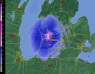
I woke up this morning to be greeted, very appropriately, by the year’s first snow accumulation. Yesterday temperatures opened in the low fifties, but they began dropping and the afternoon grew downright chilly. Today snow is falling, and out in the parking lot a woman is brushing the white stuff off of her car. It’s almost like winter has been consulting its watch, waiting in the wings and then entering the stage exactly on cue with a bucketload of lake effect. The snow will be with us for a few days, now, and the radar will continue to look a lot like the image on this page. Click on it to enlarge it, and get used to it, because you’ll be seeing a lot of similar pictures from now until meteorological spring arrives on March 1, 2011.

Yazoo City Tornado Number Two: A Stormy Night in Mississippi

Last night’s tornado in Yazoo City, Mississippi, thankfully appears to have been not nearly as bad as its monstrous EF-4 predecessor back in April, but it was bad enough. It was one in a round of tornadoes that trampled across the South yesterday afternoon on into the night. Fed by ample moisture and energized by bulk shear exceeding 60 kts and 1km helicity exceeding 300, supercells had no problem firing up and dropping tornadoes. At the time of this post, seven tornado reports have been logged for Dixie Alley–one in Louisiana and six in Mississippi. (A tornado was also reported in northwest Missouri, but that’s far removed from the southern storms and was a separate situation.)

I watched my GR2AE radar screen in disbelief last night, shortly before 9 p.m. EST, as strong circulation progressed from the southwest toward Yazoo City. “No way,” I thought. “No freeking way.” How could the same small town get clobbered by a tornado twice in the same year? It wasn’t going to happen. It just couldn’t. But it did.

At 8:18 CST a tornado warning was issued–a continuation of a previous warning–which contained the following statement: AT 816 PM CST…LOCAL LAW ENFORCEMENT REPORTED DAMAGE FROM A TORNADO JUST PASSING THROUGH THE CITY. THIS TORNADO WAS LOCATED 6 MILES SOUTH OF EDEN MOVING NORTHEAST AT 50 MPH. At that point I could see the potent SRV couplet moving right through what appeared to be the south edge of the town. According to reports this tornado crossed the path of the April storm, like a letter X. Fortunately, it appears to have been nowhere nearly as large or violent, and a scan or two later showed the mesocyclone weakening considerably as it left the city. Here is the string of reports from the National Weather Service at Jackson:

0800 PM     TORNADO          5 SW YAZOO CITY         32.81N 90.47W
11/29/2010                   YAZOO              MS   AMATEUR RADIO

            3-4 MILE LONG PATH OF DAMAGE ALONG EAGLE BEND ROAD.
            LIKELY TORNADO DAMAGE. UPDATED...VEHICLE
            OVERTURNED...STRUCTURAL DAMAGE...SHOP DESTROYED. NEAR THE
            NORTHERN INTERSECTION OF EAGLE BEND ROAD AND HWY 3.

0808 PM     TORNADO          YAZOO CITY              32.86N 90.41W
11/29/2010                   YAZOO              MS   AMATEUR RADIO

            DAMAGE TO THE COURTHOUSE ROOF IN DOWNTOWN AND A LARGE
            TREE DOWN NEXT TO THE COURTHOUSE. WIDESPREAD DEBRIS IN
            THE AREA.

0810 PM     TORNADO          YAZOO CITY              32.86N 90.41W
11/29/2010                   YAZOO              MS   AMATEUR RADIO

            ADDITIONAL STRUCURAL DAMAGE REPORTED IN YAZOO CITY WITH
            NUMEROUS LARGE OAK TREES SNAPPED AND UPROOTED. POWER
            LINES ALSO REPORTED DOWN ALONG CENTER RIDGE ROAD.

0810 PM     TORNADO          YAZOO CITY              32.86N 90.41W
11/29/2010                   YAZOO              MS   EMERGENCY MNGR

            MAJOR STRUCTURAL DAMAGE REPORTED TO AT LEAST 18
            BUSINESSES...MINOR DAMAGE TO AT LEAST 3 WOODEN FRAME
            HOUSES. ENTIRE FACADE OF ONE DOWTWON BUILDING HAD ALL
            WINDOWS BLOWN OUT. 30 PERCENT OF YAZOO CITY REMAINS
            WITHOUT POWER.

0810 PM     TORNADO          YAZOO CITY              32.86N 90.41W
11/29/2010                   YAZOO              MS   AMATEUR RADIO

            POWER LINES...TREES...AND WIDESPREAD POWER OUTAGES ARE
            REPORTED WITHIN YAZOO CITY. WILL UPDATE FURTHER WITH
            ADDITIONAL INFORMATION.
.

While Yazoo City stands out by virtue of having gotten hit twice this year, other communities also sustained damage. The show began in the afternoon and evidently continued through the night, because when I woke up this morning and fired up my computer, I saw a tornado warning in Alabama. Tornado watches are currently in effect for the southeast, and the SPC shows a slight risk extending north as far as southeastern Pennsylvania, with a 10 percent hatched area reaching from South Carolina into Virginia.

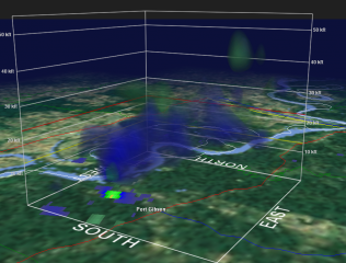
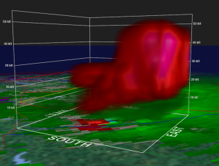
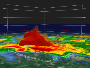
The images on this page are GR2AE volume scans of the next supercell southwest of the Yazoo City storm, heading on a trajectory just west and north of Port Gibson. Click on the images to enlarge them. The time was 0232Z, or just a couple minutes after 8:30 CST. The topmost frame shows a hook and correlated structure above it, with the suggestion of a pretty healthy BWER. The bottom frame depicts vigorous rotation.

Dixie Alley Severe Update: Yazoo City

Unbelievable. Yazoo City, Mississippi, which sustained a massive and deadly EF-4 tornado back on April 24 of this year, got hit by another tornado just a couple hours ago. A tornado warning issued at 8:18 CST reads as follows:

AT 816 PM CST…LOCAL LAW ENFORCEMENT REPORTED DAMAGE FROM A TORNADO
JUST PASSING THROUGH THE CITY. THIS TORNADO WAS LOCATED 6 MILES
SOUTH OF EDEN MOVING NORTHEAST AT 50 MPH.

A line of tornadic supercells continue to rake across Mississippi. As I write, at 9:19 CST, the most robust circulation is west of Raymond; however, weaker circulation is passing just to the north of Port Gibson. Oops, new scan in, and that circulation appears to have intensified. And there are other tornado-warned storms in progress as well.

This will be a nasty night for Dixie Alley dwellers. I’ll have more to write tomorrow, along with a couple volume scans to share from GR2AE. Let’s hope and pray that no fatalities result from this round of severe weather. Night time storms are killers.

Dixie Alley Lights Up

Severe storms have been pushing through Dixie Alley this afternoon and evening, fed by dewpoints in the mid 60s to lower 70s and propped by bulk shear in the 60-70kt range. The action has been largely in Louisiana, where tornado warnings have been ongoing for several hours and tornado damage has been reported northwest of Atlanta.

Typical of southeastern storms, these ones look pretty HP-ish, real drenchers. They’ve waned in intensity from earlier, but they’re still dangerous storms, and one of them  in East Carroll County is presently tornado-warned.

Here’s a GR2AE volume scan from the Shreveport radar depicting storm-relative velocity at 2107Z. Click on the image to enlarge it. You can see a pronounced couplet, indicating strong base-level rotation. I believe this was in fact the storm responsible for the tornado report, although two others in the same region displayed potent mesocyclones. More tornado reports may turn up from that part of Louisiana before the night is through.

Some New Audio Clips for Your Listening Pleasure

Last Monday I got together with Ric Troll (guitar), Dave DeVos (bass), and Randy Marsh (drums), and we rehearsed a few of Ric’s original tunes in his studio, Tallmadge Mill. These guys are wonderful jazz musicians, and Ric is a composer of long standing. His music can be chewy stuff to work through, but this last session the tunes started to gel and we got some pretty nice grooves going.

Ric recorded the whole session, so I’m able to share some sample tracks with you. What you’ll hear are the tunes in rough, but there’s some very nice playing going on.

The New Hip is a basic 12-bar blues, but Ric’s head suggests a soloing approach different from your standard bebop. Attempting to free myself from cliches, I incorporated a more angular style.

The Urge is a fun tune with a high-energy A section and a swinging, cooler-sounding bridge that offers a lovely contrast.

Orcs has been the most challenging number, with it’s polymetric approach and shift to 7/4. It is coming together, though, and will be one heck of a tune once we’ve nailed down the form and the feel. Listen to Randy–the guy just tears it up on the set! Here’s a second take for all you double-dippers.

If you like what you hear, check out my Jazz Page for more sound samples as well as solo transcriptions, articles, and exercises of interest to improvising musicians.

Late-November Severe Weather Outbreak In Progress

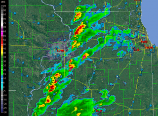
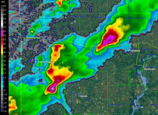
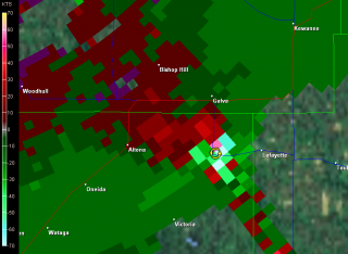
Now here’s something you don’ see very often on November 22 in the Great Lakes: supercells cruising across northern Illinois. I’d be very happy to be on either the one northwest of Toulon or the one northwest of Princeton. The storms are extending along the cold front northeast on into Wisconsin.

Whoops! The one down by Toulon is now tornado-warned. Imagine that! Here are some radar grabs. Click on them to enlarge.

And with that, I’m signing off.

Severe Weather Potential Monday in the Western Great Lakes

A couple days ago, Lisa informed me that Dr. Greg Forbes was forecasting severe storms Monday in eastern Iowa and northern Illinois. I thought, hmmm…a bit far out to be definitive, but maybe I ought to take a look. I’ve been following the models since, and after this morning’s 6Z runs, it looks like Forbes is onto something.

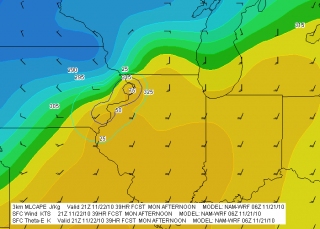
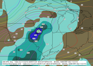
Both the NAM and GFS suggest that an area from far eastern Iowa through northern Illinois and southern Wisconsin may be under the gun in the afternoon or evening. Here are a couple of NAM maps that will give you an idea why (click on maps to enlarge). The bottom line is that a low pressure system is cranking unseasonably warm temperatures and dewpoints in the mid-50s or higher into the Great Lakes region. The potential exists for weak instability to coincide with stiff 850 and 500 mb jet cores.

The GFS paints a somewhat more aggressive picture than the NAM and wants to clip things along a few hours faster. If that pans out, then north-central Illinois and south-central Wisconsin may see the best play. But both models are calling for essentially the same thing. Note the bullseye of 500 SBCAPE and 75 J/kg 3km MLCAPE at Clinton, Iowa, coincident with a nose of Theta-E bulging into the area. The GFS depicts the same scenario, albeit at 18Z rather than 21Z.

Today, Sunday, temps are forecast to rise into the 50s here in Grand Rapids, and tomorrow they should make it into the low 60s along with a significant increase in moisture. We stand a chance for a few thunderstorms of our own, particularly when the cold front moves in Monday night. As the KGRR forecast discussion puts it, “GIVEN TEMPS IN THE LOWER 60S…IT MAY ACTUALLY FEEL A BIT HUMID MONDAY AFTERNOON. THE CURRENT MENTION OF SLGHT CHC TSRA STILL LOOKS GOOD.” The SPC day 2 outlook has even thrown in mention of isolated tornadoes from southern Michigan southward, but tomorrow’s models will give a better sense of whether that’s any real concern. Helicity should be adequate, but instability is weak, and a November night-time squall line in Michigan is not your typical tornado machine.

Right now, the bottom line looks like warmer-than-usual weather in our area today and especially tomorrow, with storms in the offing in northern Illinois and nearby areas. And behind that, setting the tone for Thanksgiving, colder weather. So enjoy this last spate of warmth, because winter is waiting in the wings.

Angularity Exercises

angularity-exercise-1-msczMuch of my playing is pretty boppish, and I’ve wanted to break it up with some different flavors and larger intervals. Lately I’ve been toying with some exercises on angularity involving couplets applied to the augmented scale, and I thought I’d share the wealth. Click on the thumbnail to the right to enlarge it.

The first two exercises are ones I’ve been woodshedding for about a week. They go well, as indicated, with altered dominant chords, but of course they work in any situation where you’d use an augmented scale. While the written exercises specify a B+7b9 chord, you can also use it with an Eb+7b9 and a G+7b9.

The third exercise outlines a half-whole diminished scale and will function as such. I’ve paired it with a B7b9, but it also works with a D7b9, and F7b9, and an Ab7b9.

While it probably goes without saying, play each exercise through the entire range of your instrument and through all twelve keys (“keys” being used here for lack of a better word). Since both the augmented and diminished scales are symmetrical scales, much of your work is done for you. You need learn only four versions of the first two exercises and three versions of the third one.

Happy woodshedding! And if you find these exercises helpful, check out the rest of the offerings on my jazz page.