June 12 Chase in Northwest Indiana and Michigan

There’s nothing fancy about these pics. They are what they are. But after a tremendously frustrating May–a rant I won’t even bother to get into right now–it is nice to have at least something to show.

The setup was a warm front strung from Iowa eastward across northern Indiana, typical of the south-central Great Lakes region. While the NWS was talking of a derecho, forecast soundings a couple days in advance seemed to point to tornadic potential. And indeed, on the day-of, the SPC issued a high risk across the area, with a 10 percent hatched tornado risk in the area where Kurt Hulst and I chased and a 15 percent hatch farther to the west.

6122013 Meso NW IN
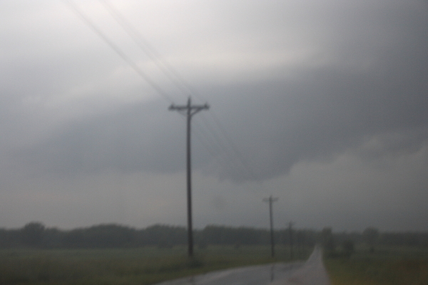
The photos show what we came up with in northwest Indiana south of Koontz Lake. The first blurry shot is of a small mesocyclone on a storm which, on the radar, gave only small hints that it could harbor one. Sometimes, given the right environment, what base reflectivity renders as amorphous blobs can provide surprises where you find a little sorta-kinda-almost hooky-looking little notch, and that was the case here.

For a minute, it actually looked like it might give us a tornado, but the lack of surface winds was a good clue that wasn’t gonna happen. Structurally, though, this little storm offered an interesting opportunity to try and read clues in the clouds as to what it was doing or planned to do. I’m not sure I ever did figure that out, but it was fun to watch.

6122013 Meso S of Koontz Lake IN
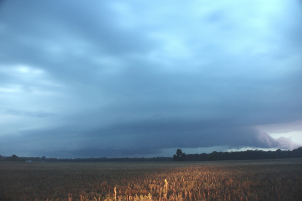
After watching it for several minutes, we dropped it to intercept the larger, more robust cell advancing behind it. This storm had displayed prolonged rotation on radar, and as we repositioned near a broad stretch of field that gave us a good view, we could see a stubby tail cloud feeding into a large, flange-shaped meso. The storm was clearly HP, with a linear look to it that suggests a shelf cloud, but there was no mistaking the broad rotary motion, and you can make out some inflow bands in the picture. At one point, a well-defined funnel formed just north of the juncture with the tail cloud (or whatever you want to call it) and the  rain core, drifting behind the core and into obscurity.

We played tag with this storm for a while, but it was toward sunset and getting darker and darker, and eventually we decided to call it quits and head back. The storms where we were just lacked the low-level helicity to go tornadic. There was ample surface-based CAPE–somewhere in the order of 3,000 J/kg, methinks– but whatever inflow was feeding them appeared to be streaming in above ground level.

So we headed back into Michigan, and as we drove north on US-31 near Saint Joseph, things got interesting fast. Green and orange power flashes suggested that a high wind was moving through nearby. A glance at the radar and, sure enough, there it was: a bow echo. It didn’t look terribly dramatic on radar, but looks can be deceiving.

Heading east on I-94, we attempted to catch up with the belly of the bow as it rocketed toward Paw Paw and Kalamazoo. The next fifty or sixty miles was a millrace of frequently shifting high winds and torrential rain punctuated by power flashes. At one point, we narrowly missed running into a highway sign that blew across the road in front of us. At another, we passed an inferno where a falling tree had evidently gotten entangled in a power line.

North of us on the radar, we could see a supercell moving over the town of Wayland. But it was a little ways beyond reach, particularly given the kind of backwoods territory that lay to its east.

The high winds and driving rain ended, ironically, as we entered Kent County. My little hometown of Caledonia got just a relative dusting of rain and maybe a zephyr of outflow. It was hard to believe how much drama was playing out just a few miles to the south.

Big thanks to Kurt for taking me out with him when I didn’t have the gas or the money to chase on my own. I needed to get out and chase, and the sneering irony of having a robust setup dropped in my backyard and not being able to do anything about it was really eating me yesterday. I got to go out after all, and it felt wonderful.


Why I Chase Storms: A Storm Chaser’s Manifesto

I posted the following message on Facebook, but it really belongs here. It is one of what I think will be a number of very personal, reflective posts on storm chasing as I process the impact of a difficult, disappointing, terrible, and tragic season.

——————————

This storm season has left me feeling very torn. As I sift through its impact on me, I am grateful for my friends who are NOT chasers. People whose perspective on life is different from mine. My men’s group, for instance, is a small circle of wonderful, godly brothers in Christ who have seen plenty of life. It felt cathartic to share with them last night about my passion for chasing storms, my sense of failure as a chaser, and the recent, tragic losses of Tim and Paul Samaras and Carl Young.

In talking with the guys about chasing, I spoke frankly about a common misconception about storm chasers: that we are out there saving lives by what we do. That may sometimes be the case, but it is not the motivating force for me or any of the chasers I know. That image, fostered by the media, simply isn’t what drives chasers. I chase, and most other chasers chase, primarily because we are enamored with the storms. There is nothing intrinsically heroic in what we do. Depending on where we’re chasing, our presence in the field can be valuable as part–and only a part–of warning the public. A few chasers–a very few, including the late Tim Samaras–collect data for scientific research, some of which could conceivably help to improve an already excellent warning system. Occasionally, some chasers find themselves in a position to make a life-saving difference as first responders. And Storm Assist is providing a fabulous means for chasers to contribute their videos to a charitable cause whose proceeds go directly to aiding the victims of tornadoes and severe weather.

All of these things are true and good. But they’re different from the myths that have arisen around storm chasing. One of those myths is that chasers are sickos who enjoy watching homes and communities get trashed; the other is that we’re more noble than we really are. Between these two extremes lies the reality of why storm chasers actually chase. And the truth is, no single reason fully describes every chaser. Chasers are individuals, and today as never before, that individual component interacts with the influence of technology and the media to create a complex and varied mix of motives.

Yet I believe all chasers possess one common denominator: a love for, a passion for, the storms. Personally, storm chasing engages me on many levels–intellectual, emotional, spiritual, aesthetic, creative, and adventurous–in a way that nothing else does. When I can chase the way I want to, I feel alive; when I cannot, which is far too often, I feel intensely frustrated, moreso than I think is healthy. Lately, my limitations have left me feeling depressed. That is something I have to work through, talk to God about, and discuss with those close to me who know me well.

But one thing is certain: I chase, as best I am able, because it is what I love to do, period. There is nothing else like storm chasing. I love the sky, the storms, their drama and beauty, their intensity, their mind-boggling motion, the awe they inspire, the landscapes they traverse, and the lessons they have to teach. I am a pupil of the atmosphere.

Because I live in a part of the country where both tornadoes and experienced chasers are far fewer than in the Great Plains, I can perhaps play a more significant role locally in helping to warn the public than in Tornado Alley, where droves of chasers line the roads. Chasing for WOOD TV8 here in West Michigan creates that possibility for me.

But I would chase regardless. It’s what I do, just as playing the saxophone is what I do and just as golfing, or car racing, or writing, or painting, or fishing, or crocheting, or hiking, or hunting, or what have you, is what you do. We’re all wired to do something, and we desire to do it excellently. There’s nothing innately noble about it, and there doesn’t need to be. Your pursuit may, in the right circumstances, put you in a position to contribute to the well-being of others. But it needs no justification in order to be worthwhile.

That is how I view storm chasing, and I think many of my fellow chasers would agree.

So please do not thank me for what it is I do, for the only thing I am doing is following my heart. In the same breath, please do not condemn me for it, for you may benefit from it someday–again, as just one facet of an excellent warning system in which I play only a part.

The Deaths of Tim Samaras, Paul Samaras, and Carl Young

When last I wrote about this year’s storm season, it was non-existent: a cold, cold April and early May with teaser setups shot to pieces by crashing cold fronts.

Funny how fast things can change–or really, not so funny. No, not so funny at all.

On May 20, non-existent turned into horrible when an EF-5 tornado ripped across the heart of Moore, Oklahoma, killing 24 people. Then, as if that weren’t bad enough, on May 31 a monstrous supercell with multiple rotations took a second swipe at the area, taking another 11 lives (at last count). I followed its progress on radar, and I don’t recall ever seeing anything like it before: just one big, amoeba-like mass of churning vortices pulverizing an already storm-shattered city. KFOR chopter cameras showed a rain-wrapped tornado approaching a highway filled with several miles of gleaming headlights, all at a standstill–hundreds of panicky motorists trapped as a mass evacuation turned into a parking lot. It was unbelievable. And it was horrifying.

I have written nothing about storm chasing for over a month. At first, it was because there was nothing to write about. Then came the Moore tornado, and after that I’ve had just the opposite problem. I have felt overwhelmed with conflicting emotions, and there is so much to say that I haven’t known where to begin.

Until now. Tonight, I can no longer keep silent. I must write.

When news of the deaths of veteran storm chaser and tornado research luminary Tim Samaras, his son Paul, and his chase partner Carl Young began to filter in last night on Facebook, I took it with the usual grain of salt. These things have a way of proving false, and I take a dim view of sensationalist reports until the facts have been confirmed.

In this case, sadly, they have been. Three bright stars in the storm chasing firmament have fallen from the sky. They were not the idiot yahoos everyone expected would one day become storm chasing’s first direct tornado casualties. They were skilled chasers, as expert and knowledgeable as they come and known for their caution and respect for the storms. Whatever circumstances surrounded their deaths in the violent El Reno tornado, it is doubtful that they involved deliberately foolish risk-taking. That wasn’t their style.

I have never met Tim, Paul, or Carl, but many chasers have, and everyone knows of Tim’s work. Simply put, he was one of the most respected names in the field of storm chasing, and from everything I have heard, one of the nicest. I have never heard anything but good words for all three of these guys. And now they are gone, torn from our midst far too soon.

There is some consolation in knowing that these men died doing what they loved. Some. But it does not mitigate the grief felt by their families and friends. Even those such as I who did not know them feel a great sadness. My heart is heavy, and my prayers are with the loved ones of Tim and Paul Samaras and Carl Young.

May you rest in peace, gentlemen. You have given the world much. Thank you.

A Crummy Storm Season and an Upcoming Video Tutorial on Circular Breathing

Well over a month has elapsed since my last post. I look at the date of that post, April 1, and think, Right. April Fool, everybody. It sure fooled me.

My exuberant expectations for this storm season, particularly compared to last year’s, have fallen so far short that they’d need to climb a step ladder just to be upside-down. Last year by this time, I’d at least gotten in two productive chases, one of them spectacular and the other decent. This year, nada. I didn’t think it was possible to have a worse chase season than 2012, but 2013 is demonstrating just how a wrong a man can be.

Now, I know what everyone says: you can’t judge the latter part of a season by its early part. I believe that. The past has proved how dramatically things can change. Chase seasons that started out crappy suddenly shaped up and started cranking out some great setups. I hope that proves true with this one. As it stands, my traditional target date of May 22, nigh sacred to me for the great chases it has provided, has been consistently flatlining on the GFS. That long-range model has me gazing wistfully at its the far, far end, willing for a shadow of hope to show up at 384 hours and remain hopeful–a nice, robust trough that survives successive runs and moves through the timeline into the Plains, where–you’ll say I’m dreaming–it actually overlays moisture and instability.

There’s actually such a shadow lurking in this morning’s GFSM. I don’t trust it, no sir-ree, not at all. Yet I hope it will show better integrity than its predecessors. Regardless, I’m crossing my fingers for late May and June.

As for this blog, its inactivity is due a depressing lack of anything stormy to write about. Oh, yeah, there was the history-making April flood that put a number of Michigan communities underwater and came within inches of overflowing the floodwalls in downtown Grand Rapids. I heard of a golf course on the southwest side of town that was under four feet of water. That’s not something you see every day around here.

So I made a point of going out and snapping some photos in my own neck of the woods along the Thornapple and Coldwater rivers. The 84th Street dam on the Thornapple was like a giant firehose, the jewel-like Coldwater Park was underwater, and a couple miles further east, vast acres of wooded floodplain had opened up to exploration by canoe. It was something to see, but I didn’t much feel like writing about it.

Fortunately, when the weather refuses to cooperate, music keeps me occupied. Last Thursday, Big Band Nouveau debuted at The B.O.B. in downtown Grand Rapids. We played our butts off and enjoyed an enthusiastic reception. I see great prospects for this band.

More immediately, I’ve been working on a video tutorial on circular breathing. In fact, I shot some video yesterday and uploaded it last night to YouTube, with every intention of posting it on Stormhorn.com today. But in reviewing it this morning, I realized that it wasn’t up to snuff. So I deleted it from YouTube. I need to do another video session before I can post.

In other words, everything you’ve just read is really a substitute for the post I had planned, featuring the video tutorial. That post is in the works, so consider this a heads-up, particularly if you’re interested in learning circular breathing.

That’s all for now. A full day of editing a client’s manuscript awaits me, and I’ve got to get to it. Sayonara.


Are the Great Plains About to Open for Business?

ECMF-GFS H5 fcst 0408013Last year’s abnormally balmy March opened for storm chasers with a lion-like roar on the 2nd with a deadly outbreak of tornadoes along the Ohio River southward. But from then on, with the exception of April 13 and 14, the season dwindled into a pathetic, lamb-like bleat.

This March has been the polar opposite, and I do mean polar. Many chasers have been champing at the bit due to a wintry pattern that has simply refused to let go. But that may finally be about to change, and April may be the month when this year’s chase season starts to howl. For the last several days, I’ve been eyeballing a large trough on the GFS that wants to invade the Great Plains around April 8, shuttling in Gulf moisture and also suggesting the possibility of warm-front action farther east on the 9th.

GFS H5 fcst 00z 040913The ECMWF broadly agrees. The first map (click to enlarge), initialized today at 00Z, compares the 168 hour forecasts for GFS and Euro heights for Sunday evening, April 7 (00Z April 8). The second map, from TwisterData, depicts the GFS 24 hours later at 7 p.m. CST.

Maybe not a poster child for negative tilting (though the 6Z run changes that), but it could signal the breaking of the Champagne bottle against the hull of chase season 2013. The details will fill themselves in as the forecast hour narrows down. Right now, this is a hopeful sign for storm chasers. Winter may still have a gasp or two left, but we’ve made it through, and change is on the way.

Prior to that, the models point to a shortwave moving through the upper Midwest next weekend. Will it have sufficient moisture and instability to work with near the warm front? Good question; we’ll find out, assuming subsequent model runs don’t wash it out. So far it has shown up consistently. For those of us who live northeast of Tornado Alley, it’s worth keeping an eye on.


F5 Data: A Swiss Army Knife for Storm Chasers Adds Some Superb New Tools

I first began using F5 Data in 2007, and despite its early developmental quirks and my own vast lack of experience at forecasting, I fell in love with it. Storm chaser and program designer Andrew Revering had a solid and unique concept, one that gave me an ample tool for both learning forecasting and chasing storms. In particular, its configurable overlay of RUC maps on top of my GR3 radar images (via Allisonhouse’s data feed) appealed to me. At a glance, I could get a good idea of the kind of environment storms were moving through and into. And I had more than 160 parameters to choose from. I hadn’t an inkling what most of them were for, but they were available to me if ever I learned.

In 2008, Andy made significant upgrades to his product with the addition of color shading and contouring, GFS at 3-hour intervals out to 180 hours, a calculator for instantly converting various units of measurement to other units of measurement ( such as meters per second to knots and miles per hour), and other improvements.  The result not only looked attractive and professional, but it offered more solid bang for the buck–and at a little over $14.00 a month, the bucks were easily affordable.

Map Overlays: An Immensely Useful Feature

500 mb Heights

CONUS view showing 500 mb height contours. Note: Images shown here do not correspond to the text example.

At the same time, my own forecasting skills were slowly improving, and as they did, I came to greatly value another key feature of F5 Data: its ability to layer any of its maps on top of each other. This is a hugely useful feature and one I haven’t seen in any other commonly available forecasting resource that doesn’t require more technical skills than I possess. F5 Data is easy and intuitive to use, and as my knowledge grew, so did my appreciation for its map overlays.

F5 Sample Overlays

CONUS view with shaded surface dewpoints and surface wind barbs added to 500 mb heights contours. Labels for dewpoints have been turned off.

F5 Overlays Zoomed

Same overlays as above zoomed in to selected area.

Say, for instance, I’m looking at the NAM 48-hour forecast for 21Z. I select the 500 mb heights map, choosing the contour setting, and see a trough digging into New Mexico, with diffluence fanning across the Texas/Oklahoma panhandles up into Kansas. How is the boundary layer responding? Switching from contours to shading, I select sea level pressure, and now, superimposed on the H5 heights, I can see a 998 mb low centered in southwest Kansas. Another click adds surface wind barbs, which show a good southeasterly flow toward the low, with an easterly shift across northern Kansas suggesting the location of the warm front. Hmmm, what’s happening with moisture? Deleting the SLP map–I don’t have to, but too many maps creates clutter–I select surface dewpoints. Ah! There’s a nice, broad lobe of 65 degree Tds stretching as far north as Hutchinson, with a dryline dropping south from near Dodge City into Oklahoma and Texas. Another click gives me an overlay of 850 mb dewpoints, revealing that moisture is ample and deep. Still another click shows a 70 knot 500 mb jet core nosing in toward the panhandles.

You get the idea. I can continue to add and subtract maps of all kinds–surface and mixed-layer CAPE, 3 km and 1 km storm-relative helicity, bulk shear, 850 mb wind speed and directional barbs, EHI, STP, moisture convergence, and whatever else I need to satisfy my curiosity about how the system could play out two days hence. I can see at a glance favorable juxtapositions of shear, moisture, lift, and instability per NAM. And I can make similar comparisons with GFS, and on day one, with RAP (which replaced RUC in May 2012).

And Now the Upgrade: Presenting Version 2.6

Everything I’ve written so far has been to set a context for what follows, which is my review of the latest major upgrade to F5 Data. It comess at a time when the number of forecasting products available online has greatly expanded and old standbys have updated in ways that make them marvelously functional. Notably, a number of years ago TwisterData gained rapid and massive acceptance among storm chasers, and it continues to enjoy prominence as a quick, one-stop resource. Like F5 Data, it features GFS, NAM, and RAP, and it also offers point-and-click model soundings, a very handy feature. In 2010, the HRRR brought hourly high-resolution maps to the fray, with its forecast radar images demonstrating considerable accuracy. And the SPC’s Mesoanalysis Graphics, always a stellar chase-day resource, has recently made some dynamite improvements. Today the Internet is a veritable candy store of free forecasting resources.

GR3 with F5 mesoanalysis overlay. This one shows surface and 850 mb Tds and 850 wind barbs. (The blue wind barbs are an Allisonhouse product.)

GR3 with F5 mesoanalysis overlay. This one shows surface and 850 mb dewpoints and 850 mb wind barbs. (The blue METARs are an Allisonhouse product.)

At the same time, F5 Data didn’t seem to be doing much, and while I still resorted to it constantly, I wondered whether Andy had lost his passion and commitment to his product. Most troubling to me, the proprietary mesoanalysis maps which had replaced the RUC maps as GR3 overlays often failed to update in a timely manner, rendering them pointless. Given their potential usefulness in the field–how valuable would it be, for instance, to see at a glance that the storm you’re following is moving into greater instability and bulk shear?–I found this disappointing.

But I no longer have any such concerns. This latest upgrade has rendered F5 Data a powerhouse. All the while, Andy was beavering away in the background, fixing bugs and incorporating various client requests into his own set of huge improvements to his creation. Beginning with the February 1, 2013, release of v. 2.5 and moving in seven-league strides toward the latest version, 2.6.1, these changes have been a long time coming, they reflect a lot of work on Andy’s part, and they have been well worth the wait.

Here’s What Is New

The following will give you a quick idea of the more significant changes:

  • NAVGEM has been added to the F5 suite of forecast models.
  • Users can now draw boundaries, highs, and lows.
  • Users can select increments other than the default by which arrow keys advance forecast hours for the different models
  • The map now offers an experimental curved-Earth projection.
  • Wind barbs at different levels can be overlaid to provide visuals of speed and directional shear.
  • Processing is faster (up to 45 minutes faster with GFS)
  • Text for geographic maps can now be customized.

And yes, the mesoanalysis maps are now on the money. Andy moved them to a faster server, and they now update regularly and consistently, to the point where I plan to display some of them on my site the way I used to do with the F5 Data RUC maps.

All of the above are in addition to the already existing array of features. A few of these include the following:

  • Over 160 parameters, including ones you just don’t find elsewhere, such as the Stensrud Tornado Risk and isentropic surfaces, and also a good number of proprietary products such as the APRWX Tornado Index, APRWX Severe Index, and APRWX Cap.
  • Current conditions plus five forecast models: GFS (out to 384 hours), NAM, RAP, hourly mesoanalysis, and the newly added NAVGEM.
  • Mesoanalysis integration with radar products via Allisonhouse (already described).
  • A point-and-click CONUS grid of forecast soundings.
  • Zoom capabilities that let you zero in on areas of interest. Activate the display of cities and roads and target selection gets that much easier.
  • National satellite (visible, water vapor, and infrared) and base reflectivity radar composites.
  • Fully customizable map overlays (as discussed above).
  • 14 categories of maps organized for particular purposes, including Severe, Tornado, Hurricane, Cold Core, Winter, Lift, Shear, and Moisture. These are fully customizable, and you can create your own categories if you wish.
  • Watch and warning boxes.

To describe all of the features that F5 Data offers would take too much space and isn’t necessary. You can find out more at the F5 Data website, which includes a whole library of video tutorials on what F5 Data is and how to use it.

Better yet, you can download the software (it’s free) and try it out for yourself with 17 free maps.

If there is any downside to the upgraded F5 Data, it is minor and purely personal. I miss the passing of the historical data feature some months prior to the main upgrade. That feature allowed me to request data for past forecast dates and hours so I could study chase setups from years gone by. I wish I still had that option. However, I understand that it needed to go in order for Andy to move ahead with his changes. The feature was peripheral to the purpose of F5 Data, evidently it didn’t get used much, and it’s a small price to pay for the big improvements to this forecasting resource.

One thing Andy might consider for a future update would be to break down SBCAPE and MLCAPE contours into smaller increments. CAPE is displayed by intervals of 100 from 0–500 J/kg, which is great; but from 500 up to 3,000, it jumps by units of 500 J/kg, and from 3,000 on up it moves 1,000 J/kg at a time. Realistically, these are just overviews of instability, and they’re in keeping with how most other forecast resources display CAPE. If you want to get more granular, you can always check out forecast soundings. Still, it’s an opportunity for F5 Data to provide a somewhat more incremental breakdown similar to that of TwisterData.

With these last two comments dispensed of, I highly recommend to you the new and improved F5 Data. It’s easy to use and flexible as all getout, and it puts a squadron of tools at your disposal, all in one eye-pleasing, zoomable interface. Of course, no one forecasting resource covers all the bases, and that is certainly true of F5 Data. But this is nonetheless a fabulous product that offers some unique advantages. These latest changes, including the addition of NAVGEM, the ability to draw boundaries, and mesoanalysis graphics that update regularly to provide the most current information, have taken an already fine resource and made it dramatically more useful.

Bravo, Andrew Revering! You do great work.

This review, by the way, is unsolicited and unpaid-for. I’ve been a fan of F5 Data and of Andy from the start, and I’m pleased to share my thoughts about the latest iteration of a product I’ve used extensively and benefited from for a good number of years.


The Foibles of Long-Range Forecast Models

Tues_March_19_GFS300hrsSometimes a picture really is worth a whole lot of words. In this case, two tell the story more eloquently than I can.

In the image to your left, the 12Z run of the  GFS depicts 500 mb height contours, surface moisture, and surface winds at 300 hours out, or twelve days before the forecast date.

The second image, taken just a little while ago, shows the same information for the same system, only now we’re down to just 66 hours from forecast time. Note that the forecast date has moved up a day to Monday; by Tuesday, the whole system has moved off to the east and out to sea. Bye-bye moisture and instability.

Mon_March_18_GFS66hrsWhat happened? The GFS happened, that’s what.

I realize that for many of my storm chasing readers, maybe most of you, I’m preaching to the choir, but some may wish to take note of the following:

Long-range forecast models are notoriously undependable and prone to change.

If you’ve never heard the colloquialism wish-casting, now’s the time to add it to your storm chasing lexicon. The further out you go beyond three days from an event, the more that attempting to forecast a chaseable setup amounts to just a hope and a prayer. Bad data and changing data amplify progressively in the numerical models, to the point where what you see at 240 hours out is subject to anything from mild to wild fluctuation and revision as the forecast hour draws closer and new data gets processed. By the time the NAM and SREF lean in, and finally the RAP and HRRR, what you see may resemble nothing like the deep, negatively tilted trough and gorgeous moisture plume that first captured your attention. The shape, the timing, wind speed and direction at different heights, quality of moisture, instability–everything can change, and it will, possibly quite drastically.

Remember the gossip chain? Anna tells Peter, “Selena just bought a used Nissan from the same car dealer where Jaden bought his truck. It’s on 44th Street about a mile from the dump.” Peter passes the news on to Sam thus: “Selena just bought a car from the same dealer where Jaden got his truck next to the 44th Street dump.” Sam tells Chelsea, and Chelsea tells Adam, and so it goes, with the information getting nuanced a little more each time until it becomes outright twisted. Finally, word gets back to Selena: “Hey, Selena, what’s this I hear about you buying the dump over on 44th Street from some drug dealer?”

It can be kind of that way with long-range forecasts.

So why even bother watching the long-range models, particularly the famously untrustworthy GFS? There are two reasons. One is, the models can provide a heads-up to the possibility of a chaseworthy setup. At 192 hours out, don’t think of the models as forecasts–think of them as potential forecasts, something to keep an eye on. A given scenario could fall completely apart and often does. But it could also develop run-to-run consistency that agrees with the short-range models as they enter the picture, and ultimately lead to a decent chase.

For those of us who have to drive a long distance to Tornado Alley, such advance awareness is particularly valuable. If you live in Chickasha, Oklahoma, or Wichita, Kansas, you can roll out of bed in the morning, look at the satellite, surface obs, NAM, and RAP, and decide whether you’re going to chase in the afternoon. But if you live in Grand Rapids, Michigan, or Punxatawney, Pennsylvania, things aren’t that easy. When you’ve got to travel 800 to 1,000 miles or more to get to the action, burning time and fuel and perhaps vacation days, lead-time becomes important, and the more, the better.

The second reason for watching the long-range models is sheer obsessiveness. Call it desperation if you wish. It has been a long winter and storm chasers are itching to hit the road. Some of us just can’t help ourselves–we want to see some flicker of life, some sign of hope, some indication of the Gulf conveyor opening for business beneath a warming sun and dangerous dynamics. What’s the harm in that? Most of us know enough not to hang our hats on a 120-hour forecast, let alone one that’s two weeks out. But it doesn’t hurt to dream. After all, sometimes dreams come true.

Remembering the Henryville EF4 Tornado: A One-Year Retrospective

We were three-and-a-half miles north of Palmyra, Indiana, when the tornado crossed the road less than a mile in front of us at Dutch Creek Road, ripping up a 12 x 12-foot section of asphalt in the process and throwing it in chunks into an adjacent field. Within about a minute, the vortex had morphed from a wispy rope into a powerhouse of a stovepipe, tearing tangentially across our path as Bill Oosterbaan and I blasted north on State Road 135.

Bill is no timid driver, and he did a heck of a job keeping pace with the beast. But the storm was a missile, moving at least 60 miles an hour, and once we hit downed power lines at Dutch Creek Road, we had to let it go. We had no idea of the tragedy it was about to inflict to our northeast. But, watching the white condensation funnel billow and intensify beyond the treeline, with secondary vortices wrapping around it like a cloak, we could tell it was a monster. As I filed a report on Spotter Network, Bill turned around and headed back south. A second supercell was hot on the heels of the one we had just let go, and repositioning became our immediate concern.

Bill and I had just been fortunate to catch and videotape the Henryille EF4 tornado in its formative stages. We first glimpsed it south of Palmyra as it descended from a wall cloud several miles to our west-northwest. It didn’t look particularly impressive at that point, but as we closed in, the fast-moving circulation began to display wild shapes and motions, then condensed fully and finally just before crossing the highway.

It seems incredible that  in the few meager seconds the tornado took to translate across SR 135, it managed to rip up a large section of road. The term “asphalt scouring” just doesn’t apply; there was no scouring involved. An estimated 10,000 pounds of pavement got literally torn from the downwind side of the highway and thrown something like one hundred feet. I didn’t witness this road damage and only found out about it later. But chaser Simon Brewer provides a good description of what he saw just a few-score yards north of where Bill and I turned around.

The wider damage path associated with the main tornado circulation was easily visible from a forest west of the highway through a field, and past the highway through another forest to the east. Also, an individual suction vortex damage path was easily found starting in the field scouring vegetation and tossing boulders from a drainage ditch, then crossing a section of highway peeling and tossing massive slabs of asphalt, the largest broke upon second contact with the ground (it bounced leaving an significant impact crater) on the downwind side of the highway. Typical sphalt scouring is usually associated with EF3 and stronger tornadoes, but typical asphalt scouring is found on rural roads with relatively thin asphalt 1-2 inches or less thick. It’s amazing to think how short a time period the small suction vortex was probably over that section of highway; maybe only a second tops! I usually don’t stop to investigate tornado damage, but when I saw the highway damage on March 2nd I was blown away! I took more photos of the road damage than I did the storm and tornado. I consulted Dr. Greg Forbes and he agreed this was one of the most incredible damage cases he’s heard, only possibly being eclipsed by the trench created by the Philadelphia MS EF5 on April 27, 2011.*

A year has passed since all of the above took place. At the same time last year as I am presently writing these words, Bill and I were nearing Louisville, and within another hour or so we would shift into chase mode, head west, and intercept our storm. Click here to read my complete account of that chase, including my video of the tornado as well as radar images and skew-Ts.

Today the weather is drastically different. This March is behaving like March, not May, and in light of last year’s prolonged heat wave and disastrous drought, I am glad. I will be delighted to see another round or two of good winter weather bring still more moisture to the Plains and Midwest and prime the pump for storm season. The storms of spring will get here soon enough, and while nothing is certain, my hunch is that this year will be better than last year.

_______________

* Simon Brewer, from his January 14, 2013, post in the Stormtrack thread The EF Scale and Asphalt Scouring Caused by the March 2 Henryville Tornado. Also see Simon’s and Jim Bishop’s chase account, which includes photos of the road damage, at their Stormgasm website. You can see Dutch Creek Road just past the road sign and parked car in the background of the first photo.

Enter March: No Repeat of 2012

March 2 2013 GFSMarch 2013 won’t be making anything like last year’s brutal grand entry. For residents of the Ohio valley, that is a good thing. On March 2 a year ago, unseasonably springlike conditions fostered an outbreak of tornadoes, including the violent Henryville, Indiana, tornado that my friend Bill Oosterbaan and I intercepted north of Palmyra.

This March’s arrival portends nothing like that. One look at the map (click to enlarge) will show you that conditions are quite different from last year. The model is today’s (February 27, 2013) 00Z run showing the 500 mb heights and surface temperatures for March 2 at 21Z. With a ridge dominating the western half of the CONUS and cold Canadian air sitting atop the Great Lakes, the picture doesn’t even remotely resemble the 2012 scenario that sent storm chasers scrambling for their gear. A few days prior to the event–that is, right about now–we were casting anxious eyes on the embryonic system with the sense that northern Dixie Alley was in for it.

I’m frankly glad that a cooler, more quiescent opener is in store for the 2013 meteorological spring. I will be pleased to get more snow, and I hope the Midwest and Great Plains get a few more good, solid dumpings before storm season arrives in earnest. Storm chasing aside, the more moisture, the better for regions that have languished under severe drought. As inconvenient as the recent blizzard was for west Texas, I’ll bet the folks in Amarillo were mighty glad to get that much snow. I hope they get more, or just water in abundance in whatever form it takes.

This March may be entering on the cold side, at least here in Michigan, but that’s okay. It is March, the month of transition. I’m equipped with a “new” used car, a 2002 Toyota Camry that is drum tight and ready to take me wherever I need to go in order to see tornadoes. It won’t be long now. See y’all under the meso!

Respect for the Victims: Some Thoughts on Storm Chaser Banter

Several weeks ago, en route toward a storm chasers’ conference in Minneapolis, my long-time chase partner Bill Oosterbaan and I caught lunch in Parkersburg, Iowa. Five years before, on May 25, 2008, Bill, his brother, Tom, Jason Harris, and I had intercepted a tornadic supercell half an hour after it leveled the southern third of that town, claiming seven lives. It was the second EF-5 tornado recorded using the Enhanced Fujita Scale (the first tornado destroyed Greensburg, Kansas, in 2007), and I was curious to visit the community it had impacted.

As we headed north into Parkersburg, just two signs of the disaster greeted us: wind-torn trees which bore silent testimony to the horror of that grim afternoon, and street after street of new homes and commercial structures. In that 150-year-old prairie town, the delineation between old buildings to the north and brand-new ones to the south was sharp, and it was telling. This town had endured something far beyond a bad windstorm. It had been forever altered by one of nature’s most violent and lethal forces. In just two or three brief minutes, one-third of the town had been swept away–homes leveled, businesses demolished, loved ones lost, bodies maimed, traumatic memories imprinted indelibly in the minds and emotions of survivors, and the history of an entire 1,870-person community dramatically shaped. Henceforth, Parkersburg would be one of those towns whose residents speak in terms of “before the tornado” and “after the tornado.”

As Bill and I walked down the sidewalk toward a family restaurant in the old downtown section, Bill remarked, “I can hardly wait to get out and chase this spring! Man, I hope we get some good storms.”

“Careful,” I said. “Remember where we are.”

Bill understood immediately. “Good point,” he agreed.

It’s so easy for even older, long-time chasers like Bill and me to forget. We’re enthralled with tornadoes and severe storms, we’re passionate about what we do, and we love to talk about it to the point where we lose track of how terribly dark the dark side of our interest can be. But those who have survived that dark side can never forget.

I look forward to an active storm chasing season this year, certainly better than in 2012. But as we chasers begin to feel our blood stir with the approach of spring, let’s bear in mind what we’re dealing with. We’re sometimes glib in our speech, and we say things jokingly or casually that we don’t really mean.

On Facebook and other social media, I run across comments like, “Bring on the EF-4’s!” or, “I hope I see an EF-5.” That’s typical chatter for storm chasers, particularly newer ones. But do you really want to see an EF-5? Remember, the EF Scale is a damage rating, so consider its implications. Saying that you’d like to witness an upper-end-EF tornado is different from saying you hope to see a mile-wide, violent wedge.

I would love to see just such a wedge, or two, or five or more, churning across the open plains this year. Gimme, gimme, I’m a junkie!

But would I like to see an EF-5? No. Not considering it most likely means that neighborhoods have been leveled and people killed. I hope I never, ever witness something as horrible as Joplin.

On three occasions, twice by night and once by day, I’ve tracked tornadoes as they hit towns. Chances are, eventually I’ll see something along the lines of Greensburg, and I’ll have video to show and a story to tell. But that will simply be because I was following the storm, not because I expected or wanted it to do something awful. Even EF-3 and lower tornado damage reflects a terrifying, hugely impactful, and sometimes deadly event for those in the path of the whirlwind. Chasers who witness such destruction inflicted on a community are sobered by it, shaped by it, and sometimes haunted by it.

So as we enter tornado season, let’s be mindful of what these storms can do and have done, year after year in town after town. My enthusiasm for chasing may not be be shared by the waitress who’s serving me lunch in some small Kansas town, who lost her home, husband, and child in a storm.