Exploring the Lydian Flat Seven Sound (or, Ruminations on a Flatted Fifth)

Hey, there, fellow jazz saxophonists and other jazz instrumentalists, I haven’t forgotten you! Even as I’ve been blogging about the big, late-October weather system that has been blowing through the Great Lakes, I’ve been contemplating my next post for sax players. I hope you’ll find that what follows was worth waiting for.

A riff from Jimmy Forrest

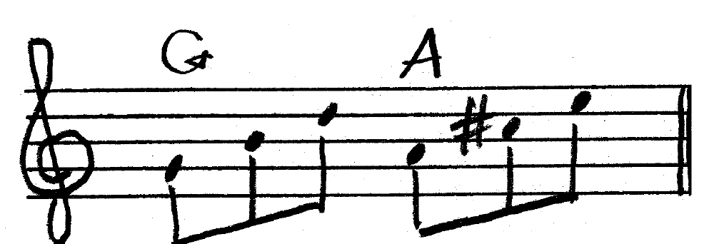
Back in my college days, Basie tenor man Jimmy Forrest lived in Grand Rapids. Naturally, I owned one of his albums, a vinyl LP titled “Black Forrest.” It was a hard-swinging, straight-ahead collection of tunes that showcased Jimmy’s ability to deliver both high-testosterone bebop and wonderfully lyrical balladry. The album included a heaping helping of blues, and in one of those blues, Jimmy worked into his solo a lick reminiscent of the old Jetsons cartoon theme song, which sounded something like this:

I liked that lick, and I incorporated it into my blues playing. The thing that made it sound so hip was the sharped fourth–aka the flat five, though in this application, that’s not the correct theoretical term–which defines the lydian sound.

What makes lydian sound so lydian?

Good question. There are two scales that can be considered lydian: the traditional lydian church mode built off the fourth degree of the major scale, and the lydian flat seven scale, also known as the lydian dominant.

The term “lydian dominant” is a bit confusing, since each word, “lydian” and “dominant,” suggests a function of the scale that cancels out the other one. In this case, however, “lydian” refers to the raised fourth scale degree, and “dominant” describes how the scale and its characteristic chord function. The more accurate term is actually “mixolydian sharp four,” since the scale is used the same way that a standard mixolydian mode is used: as a scale choice for dominant seventh chords.

Whatever you wish to call it, the lydian flat seven sound is defined by its raised fourth scale degree. But other scale options for dominant seventh chords also contain the raised fourth/flatted fifth. The half/whole-step diminished scale and the diminished whole tone scale both come instantly to mind. What makes the lydian flat seven different?

Its consonance with an unaltered dominant seventh chord.

Following is a G lydian flat seven scale, which you would use over a standard G7 chord:

Lydian_Dominant_Scale

Note that this scale neither raises nor lowers the ninth of the G7, nor does it alter the fifth, nor does it lower the thirteenth. Only the fourth degree gets raised a half-step to create the characteristic lydian sound. The raised fourth doesn’t clash with the third of the dominant chord the way that the unaltered third of the standard mixolydian mode does, in effect making the lydian flat seven scale the more consonant scale.

Triad superimposition

When you build triads off of the first and second degrees of the lydian flat seven scale, each triad is major in quality. For instance, a G lydian flat seven scale gives you the following:

Lydian_Triad_Couplets

Note that the first triad outlines the foundational notes of the G7 chord, minus the seventh, while the second triad emphasizes the ninth, raised fourth, and thirteenth. Thus,  a quick way to emphasize the lydian sound over a dominant seventh chord is to superimpose a major triad whose root is a whole step above the chord root. In other words, if you’re soloing over a Bb7, play a C major triad; if you’re working with a D9, play an E major triad, and so forth.

By the way, since neither triad includes the seventh of the scale, you can apply the above superimposition equally well to both the G7 and Gmaj7 chords.

Major triad couplets in inversion for the lydian sound

Okay, time to start getting the stuff I’ve just covered into your fingers and your ears. Click on the exercise to your right to enlarge it. It’s a practical extension of the superimposition principle I’ve just described that takes you through different inversions of the triad couplets based on the G lydian flat seven scale. As always, take the exercise up and down the full range of your instrument, and through all twelve keys.

I’ll have more to say about the lydian flat seven scale, but this ought to keep your woodshed smoking for a while.

Visit my jazz page for more articles on jazz improvisation, jazz theory, and saxophone playing.

An October Great Lakes Wind Machine

Geeze, is it ever blowing out there! The low pressure system that I’ve been harping about this past week has been moving through the Great Lakes, bringing with it temperatures in the low 70s, rich dewpoints, heavy rain, and wind gusts as high as 48 miles an hour.

Here’s a grab of the current conditions at 9:15 eastern time. Click to enlarge.

The 980 mb low has nudged off the Minnesota border into Ontario and continues to deepen rapidly as it heads east. You can see the line of storms firing along the cold front all the way down into the Gulf. Mississippi and Alabama got hammered earlier with an outbreak of supercells, but that action seems to have died down now. Not so the wind here in Grand Rapids, Michigan. It began picking up from the south in the afternoon, but it has now veered to the southwest with the passage of the cold front.

Temperatures have dropped over ten degrees over the past hour or so. The KGRR station ob says 58 degrees, but just 60 miles to my east, KLAN is registering 70 degrees.

There won’t be much left of the leaves come tomorrow morning. This system has been typical of a Michigan October–a wind machine that denudes the trees, delivering the coup de grace to the warm season and requiring those of us who live in the Great Lakes to gird our minds for winter. Ugh! These next five months won’t be fun.

The Farmers’ Almanac Secret Weather Formula: Even Eric Rasmussen Doesn’t Know It–But One Man Does

In a recent post, I poked a bit of gentle fun at the Farmers’ Almanac’s long-range forecasts, speculating that the Almanac’s weather sages were consulting woolly bear caterpillars to determine the nature of the coming winter.

Writing the article was good for a grin, but doing so got me to wondering: How the heck do those folks over at Farmers’ Almanac go about making such perilously far-out weather predictions, anyway? Surely they must have a few highly knowledgeable weather heads on staff with access to some extremely sophisticated technology, along with a formidable understanding of global climatology, oceanography, and whatnot.

So I posed the question on Stormtrack, and Lansing meteorologist Rob Dale responded with a link back to the Almanac which answered my question beautifully. Turns out the Farmers’ Almanac is far more advanced than I ever dreamed.

What’s their secret? A roomful of meteorologists hunched over sophisticated computers? A database brimming with decades worth of climatological statistics?

Nope. The Farmer’s Alamanac doesn’t need computers, and it doesn’t need no stinkin’ mets, climatologists, or databases. No, they’ve got something better: a solitary “calculator” named Caleb Weatherby and a nearly 200-year-old, proprietary formula developed by the Almanac’s founder, David Young, which allows Weatherby to calculate the Almanac’s forecasts several years in advance.

Did you get that? Several years. We are no longer talking weather forecasting here, we are talking prophecy. But perhaps prophecy is one of the secret ingredients blended into Young’s incredible formula.

According to the Almanac, “Since 1818, this carefully guarded formula has been passed along from calculator to calculator and has never been revealed*.” No one else besides Caleb Weatherby knows it. Not the SPC, not NASA, not the CIA, not Chuck Doswell, not even your mother.

While the formula eludes even the lofty craniums at NOAA, who must resort to more primitive devices such as GOES, Doppler radar, atmospheric soundings, numerical models, and a fleet of high-tech computers, the Almanac assures us that their formula “considers many factors, such as sunspots, moon phases, and other astronomical and atmospheric factors and conditions.” They forgot to mention eye of newt, but I suppose that would be giving away too much.

Just in case you’re doubtful, the Almanac furnishes a long list of their forecasting triumphs. I have to tell you, though–and I don’t wish to shock you, but confession is good for the heart–that I’m nevertheless a bit skeptical. Spin is spin, and a lot of things can be spun, including the conclusions extrapolated from weather statistics and meteorological crapshoots.

To be fair, the Almanac admits that “weather forecasting still remains an inexact science. Therefore, our forecasts may sometimes be imperfect. If you are planning an outdoor event, we recommend that you also check forecasts from local sources.”

That last, modest caveat is a bit of good advice, and if you’re a fan of Farmers’ Almanac forecasts, you’d do well to take heed. Go ahead and plan your family reunion picnic at the park six months in advance based on what the Almanac says; but if I were you, when it comes down to the week of, I’d place a whole lot more faith in the predictive expertise of your local WFO than in something generated by the Almanac’s calculator several years prior. I mean, you never know–ol’ Caleb might have been missing a few essential chicken bones from his rattle when he was doing his forecasting dance for that day.

Now, please, please, please…if you’re a die-hard devotee of the Farmers’ Almanac, don’t take me too seriously. I’m just having fun, but I really think fondly of the Almanac. It’s a beloved and revered slice of Americana that bears a torch of genuine, irreplaceable folk wisdom, and if you swear by its forecasts, great. Continue to swear by them (or at them, when they don’t pan out quite the way you expected). I’ve personally enjoyed reading them, and they’re harmless enough. The world would be a poorer place without them, and certainly less amusing.

But when it comes to chasing storms or going camping, I’ll probably look elsewhere for my weather information. Punxatawney Phil, for instance. He’d make a great chase mascot, and I’ll bet he’s  a whiz at pinpointing storm initiation.

______________________

* All quotes excerpted from the Farmers’ Almanac article, “How does the Farmers’ Almanac Predict the Weather? [sic]” Article’s web page address at the time of this blog post: https://www.farmersalmanac.com/farmers-almanac-forecasts

Friday’s Outlook: A Real October Leaf-Stripper

Whichever model gives the more accurate picture–the GFS or the WRF-NMM–one thing is sure: we Michiganians can say good-bye to the leaves. This Friday’s weather system promises to be a real October leaf-stripper, with a formidable low-pressure center deepening rapidly as it moves through Ontario.

The two forecast models continue to differ in timing, with the GFS moving the cold front rapidly through the state’s mid-section by 18Z, while the NAM plays it more conservatively and backs the surface winds considerably more. The NAM is also much more aggressive with 850 mb winds, with the 12Z run calling for 75 knots (!!!), while the GFS dribbles out a paltry 55-knot LLJ.

I have a hunch that the GFS is closer to the truth, though of course, time will tell.

Both models agree that instability will be non-existent. Not much there to gladden the heart of a storm chaser. But by golly, we’ll be seeing some wind. Bye-bye leaves!

For the sake of comparison, I took a sampler of 6Z model soundings for both the GFS and the NAM for Jackson, Michigan–a nice, central location that should offer a good compromise between both models. The differences are striking. Click on the images to enlarge them. For 21Z, I’ve shown only the NAM; by that time, the GFS has the winds lined out.

Forecast hours for Friday, October 30

15Z

GFS

NAM

18Z

GFS

NAM

21Z

NAM

Storm System Poised to Hit the Great Lakes on Friday

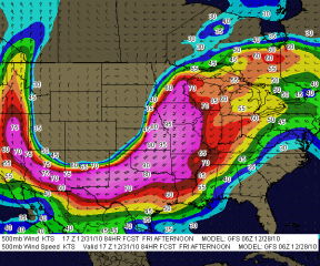
Looks like one heck of a storm system will be moving into the Great Lakes this Friday. Today’s 18Z GFS shows a potent, 976 mb low centered on the Minnesota/Canada border on the 30th at 18Z, deepening to 972 mb as it moves northeast into Ontario by 00Z. The ECMWF is less aggressive in its timing, and I hope it’s the more accurate of the two long-range models, since I think it offers better potential for more than just straight-line winds.

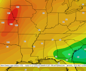
While they may not be perfectly in sync, both models agree that we’ll be seeing some heavy weather on the 30th. It’s not exactly a storm chaser’s dream scenario, with little in the way of directional shear and with storm motions in the warp speed range. I see “linear” written all over this event. But this time of year, I’ll take whatever I can get and be grateful.

Positives: dewpoints in the 60s reaching into Michigan, at least a semblance of CAPE at around 500 j/kg, and certainly no lack of bulk shear. Judging by the size of the system and the tightness of the isobars, we are in for a real October leaf-stripper.

And here comes the old disclaimer we all know and love: we’ll see what further model runs reveal. The NAM will be adding its paint to the picture shortly. I wish it would agree with the Euro in slowing the system down, giving Indiana and Michigan a good dose of moisture along with backed surface winds. Fingers crossed and hoping for a gift, because this will very likely be my last shot at anything resembling severe convection until March or April, 2010.

The Farmers’ Almanac, Woolly Bears, and Government Cover-Ups

Given the unreliability of long-range forecast models, there’s a lot of justifiable skepticism in the storm chasing community when someone (like me, for instance) talks about an event that’s 120 or more hours out. Beyond maybe three days, trying to forecast weather events becomes increasingly like reading tea leaves. We watch the ECMWF and GFS for signs of agreement and consistency, and if they start showing up, we cross our fingers, knowing that a lot can happen between now and payday.

So I’m not sure what to think when the revered Farmers’ Alamanac gazes into its crystal ball and issues with serene confidence the following prognostication for the Great Lakes region:

November 2009
1st-3rd. Sunny, with increasing clouds. 4th-7th. Rain spreads in from the west. Turning clear and frosty. 8th-11th. Rapid temperature changes. Storm moves east, with heavy rain or wet snow. Frigid cold air follows. 12th-15th. New storm moves into Great Lakes. Heavy rain and/or wet snow. Then clearing and very cold. 16th-19th. Storm sweeps across the area, followed by very cold air. Fast-moving storm, reaching the region by the 19th. Heavy snow, followed by colder air. 20th-23rd. Cold Canadian front brings rain and thunderstorms for the Great Lakes region. 24th-27th. A wet Thanksgiving.  28th-30th. Few rain or wet snow showers. Turning colder.

December 2009
1st-3rd. Rain and wet snow shift into the Great Lakes, south to Kentucky, followed by clear and cold weather. 4th-7th. Storm Ohio River Basin deposits heavy rain and wet snow. Very cold air follows. 8th-11th. A “winterlude” for Great Lakes and the Ohio River Basin. Temperatures still well below seasonal norms. 12th-15th. Scattered snow showers and flurries. 16th-19th. Considerable cloudiness over most areas, but little precipitation. Nights are seasonably cold, days are mild. 20th-23rd. Rain and/or snow.

Not being a climatologist, I’m unaware of what sophisticated meteorological resources the Farmers’ Almanac may be tapping into. Possibly they’ve been consulting woolly bear caterpillars. According to folklore, you can tell how severe the winter will be by the ratio of brown to black banding on the woolly bears. Plenty of brown means a mild winter; wide black bands with little brown points to a nasty snow season. A few weeks ago, I found an all-black woolly bear. I knew that couldn’t be good.

If only we could get the woolly bears to cooperate when storm chasing season is underway. But the little critters have other things on their minds by then, namely, pupating and becoming Isabella tiger moths. So I guess we’re stuck with the Euro and the GFS. Or sacrificing chickens, though the research supporting the link between chicken sacrifice and improved storm intercepts is slim.

No doubt the government is covering up the information, just like they do everything that’s related to severe weather. They want us to remain ignorant, unsuspecting guinea pigs while the weather gods at Norman conduct their insidious experiments, using their array of antennas and radars to generate monster tornadoes 400 miles away and then guide them unerringly through populated areas. Take the May 13 Kirksville, Missouri, tornado, for instance. That one had Government Issue written all over it. The lack of a single shred of substantiating evidence just goes to show how expert Big Brother is at keeping the truth hidden.*

That’s why you’ll find no NOAA papers correlating tornado outbreaks and chicken sacrifice. Same with woolly bears and long, hard winters–though the Farmers’ Alamanac folks, bless their hearts, have obviously made the connection, and hence, they have the weather for November and December pretty well locked in. I call that kind of forecasting ability reassuring.

As for the rest of us, well, we’ve got the ECMWF, the GFS, and tea leaves. How do you like your tea?

_______

* The following disclaimer is intended only for those who take me seriously: I’M JUST KIDDING! Sad that I’ve even got to say it, but the truth is, some folks out there do in fact believe some damn crazy things about the government’s ability to manipulate the weather. I’m not one of them, and I wouldn’t want to be mistaken for such.

That being said, I would love to see the SPC’s research on chicken sacrifice and tornadogenesis.

COD Severe Weather Symposium: Are You Going?

It’s drawing closer, and I’m getting excited. I’m talking about the College of DuPage’s upcoming Severe Weather Symposium, which will be held November 5-7. With a lineup of presenters that features some of the foremost luminaries in severe thunderstorm research, the event promises to be stellar.

I’m surprised I haven’t seen more talk about it on Stormtrack, but maybe that’s because the symposium is being held in Chicago rather than out in the Great Plains. Or perhaps it’s because the midweek timing puts a crimp on people who have to work.

But while proximity may be an issue for some and scheduling for others, the content is compelling enough that if you’re anywhere within a couple hundred miles, it will truly be your loss if you don’t make time for this event. Looking over the agenda, here’s what I see:

* All of Thursday afternoon is devoted to various aspects of convective initiation. If you want to improve your targeting skills with the latest information, this day alone ought to be worth its weight in gold.

* Day two focuses largely on tornadogenesis, but includes other topics such as a photogrammetric analysis of the Elie, Manitoba, F5 tornado, and issues in severe weather warnings. The latter presentation will no doubt address the hotly contended use of the enhanced “tornado emergency” wording.

* Day three will…well, look, here’s the complete agenda. You can read it for yourself, and conclude, as I did, that this is going to be a standout event for storm chasers.

I’ve been waiting for a long time for another severe weather conference courtesy of Paul Sirvatka and the College of DuPage. I attended two of their symposiums some years ago, back when my storm chasing skills were still very formative, and each one was time well spent. This one looks to be the best yet. Poised between the end of a stormless autumn and the long, desperate, SDS-riddled winter months, it will provide a welcome immersion into the world of tornado research and operational forecasting that ought to bear dividends when the Gulf reopens for business again next spring.

My White-Top Pitcher Plants Are Open for Business!

Bugs, beware! My white-top pitcher plant, Sarracenia leucophylla, has sent up its flush of autumn traps. The two largest traps are open, and they are spectacular. And, I might add, with the weather warming up these past couple of days, they have been doing business. I was there just in time to witness the first

hornet fall prey to one of the newly opened leaves. It landed on the lid, poked around for a bit, then promptly dropped straight down into the tube and wedged hopelessly at the very bottom. Today, with the sun backlighting the leaves, I could see the shadows of more insects, some struggling to get out. It was a rather grim drama playing out under the bright sunshine, but I’m no fan of yellow jackets, and I find it hard to feel much pity for insects that have been known to land on me and sting me just for the apparent mean-spirited hell of it.

Anyway, the two newly opened leaves look stunning, and four more are in various stages of development. I thought I’d share a photo with you; click on the image to enlarge it. You’ll find more shots of the white-top and other North American pitcher plants in the Wildflowers & Outdoors section of my Photos page.

The Quintessential Encounter: Four Transformative Days in the Ozarks for Business Professionals

If you’re a business owner or executive, this post is for you. It’s admittedly a tangent from my normal focus on jazz saxophone and storm chasing, but I’ve a hunch that a few of you may benefit from the digression.

This is to notify you of The Quintessential Encounter–a four-day retreat at an award-winning lodge in the heart of the Ozark Mountains that can help you set, and equip you to attain, your professional and life goals.

Sounds pretty addy for a blog, eh? Well, as I’ve said, this is a departure from my usual style, and in fact it’s the first time I’ve ever pushed a non-weather, non-music related event on Stormhorn.com. But the person who is organizing The Quintessential Encounter, executive life coach and mediation/negotiation specialist Lorraine King-Markum, is a close personal friend of mine. I know her vision, I know her capabilities, and I know the quality of experience she intends to deliver. The woman is incredible, and I can say with confidence that if you’re among the twelve lucky people who will participate in this retreat, which is scheduled for May 25-28, 2010, you will find that it truly lives up to the description, “life-defining.”

It will also very likely be the most enjoyable developmental experience in your career. I’ve visited the Big Cedar Lodge, and it is sublime. Lorraine is going to great pains to provide a beautiful and relaxing environment for a very different kind of business retreat–one that serves you rather than the promoters; one that will invigorate and inspire you rather than leave you feeling brain-dead after eight hours of mind-numbing presentations.

In Lorraine’s words, “The age of ‘market them to death’ while they are exhausted and impressionable is over!”

Whether you’re a beginner or seasoned business veteran, this transformational event is going to give you easy-to-follow blueprints for unlocking the lifestyle and business success you’ve been striving for. You will be mentored through the revolutionary new CRAFT coaching system, which provides real life applications.

Your registration fee includes:

* three nights at the award-winning Big Cedar Lodge from Tuesday evening, May 25th to Friday, May 28th

* a welcome party

* two meals a day plus snacks

* all experiential exercises

* workbook

* coaching sessions

* making a product to sell online

* all facilities at Big Cedar

There you have it. For more information or to make a reservation, visit the website or email Lorraine at lorraine@kingleadership.com.

“Giant Steps” Licks and Patterns

After posting a couple days ago on how to use the augmented scale with “Giant Steps” changes, I’ve experienced a renewed interest in woodshedding John Coltrane’s high-hurdle chord cycle.

There was a time in my musical life, maybe ten years ago, when I became moderately obsessed with “Giant Steps.” I painstakingly wrote down my practice material in a music notebook, which I continued to add to until I had a veritable blizzard of ideas to work with.

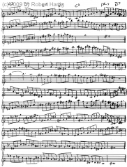
Today, looking through the web, I see plenty of resources that explore the theory behind the changes to “Giant Steps.” However, I don’t see much in the way of licks and patterns, of application-oriented stuff that a sax player can actually wrap his or her fingers around. So, since I’m presently re-exploring my “Giant Steps” notebook, I thought I’d share a page with you.

Click on the image to the right to enlarge it. It’s all hands-on stuff. If you want to study Coltrane’s theory involving key centers moving by major thirds, you can find plenty of information on the Internet, such as this excellent Wikipedia article. But understanding the “Giant Steps” cycle isn’t the same as playing it, and that’s where this article can help.

One caveat: since I’m an alto sax player, I wrote out the changes in my key. If you play an instrument pitched in Bb or C, such as tenor sax or flute, you’ll need to transpose.

The patterns shown here are for the first four bars of the tune’s A section. With it’s lopsided arrangement of V7-I cadences–which would be simple enough in themselves to negotiate if Coltrane hadn’t placed the bar lines so inconveniently–this section is the one that can be hard to master. I wrote out material for the B section as well, but what I’ve shown here will probably be more to your immediate interest.

Enjoy the material, practice hard, and have fun!

UPDATE: My entire “Giant Steps” practice notebook is now available for sale in C, Bb, Eb, and bass clef editions. Using music notation software, I transcribed all of the handwritten material (including the above image) into a clear, easy-to-read format; wrote a front section that discusses the basic theory of Coltrane changes and gives tips and insights for practice; and had a cover professionally designed.

The Giant Steps Scratch Pad is available as

* PDF download–$9.50

* Print edition–$10.95 plus shipping

The PDF will provide you with the full contents of the book instantly and save you money. The print edition gives you the complete, finished production complete with glossy cover. If you enjoyed the licks and patterns on this page, then The Giant Steps Scratch Pad is for you. View page samples from the Bb edition and order your copy today!