Next Week: Troughing in the Picture?

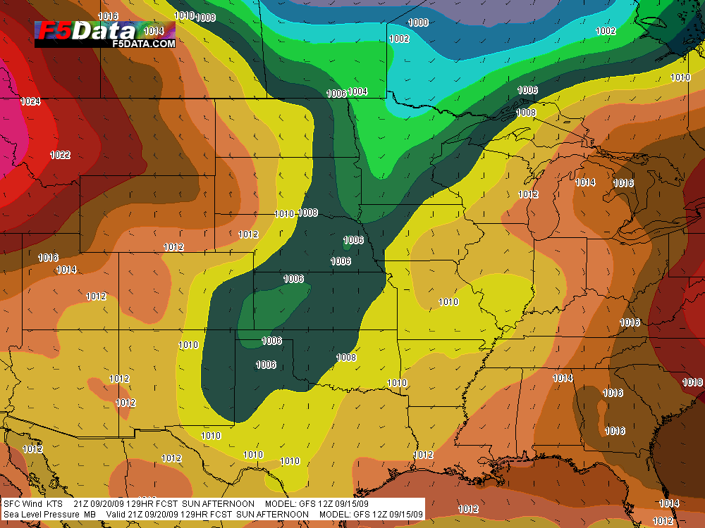
I’m prepared to get my hopes up a bit. The ECMWF and GFS both now appear to agree on a trough working its way through the country’s mid-section. Here’s the current GFS for 21Z Sunday afternoon:

GFS Sea Level Pressure for 21Z Sunday.

GFS Sea Level Pressure for 21Z Sunday.

Granted, there’s a lot more that needs to happen, such as mid-level winds and moisture connecting, but this will do for starters. It’s a better picture than yesterday.

The GFS wants to move this system through faster than the ECMWF, but at the moment I’m not going to worry my head about it. All I care about right now is, both forecast models are pointing to a bit of troughiness taking shape. It’s something to keep an eye on. Fingers remain crossed, and while I’m still not holding my breath, I’m hoping that the next few days will offer some reasons to do so.
Chasing Storms after the Concert

Bill, Kurt, and Tom are leaving tonight to chase Saturday’s setup out west. I’m staying behind to play with Francesca and Friends at the 2009 Grand Rapids Festival of the Arts. Ordinarily I’d feel a bit torn, but I have an idea that the better action will be on Sunday and–from the looks of the 12Z NAM-WRF–Monday. So when I step onto the stage tomorrow afternoon, unless between now and then a confluence between the NAM and GFS suggests that capping will suddenly no longer be an issue and Armageddon is going to break out in the Great Plains, I will be a man at peace.

But directly after the concert, I plan to pack my bags and head for the Corn Belt, where I’ll hook up with the guys and chase storms on Sunday and, if the present NAM-WRF comes at all close to verifying, Monday.

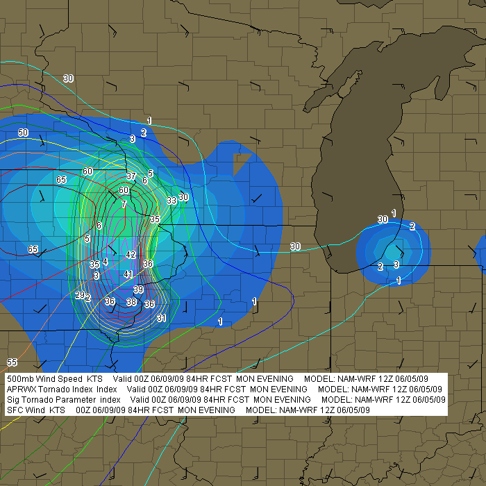
Frankly, I’m somewhat skeptical about Monday. Previous runs have consistently painted such a different scenario, with majorly veered surface winds and a unidirectional flow overall, that the 12Z’s placement of the weak surface low in eastern Iowa seems too good to be true.  Here’s an image from F5 Data showing sigtors, APRWX sigtor, surface wind barbs, and H5 wind speeds:

12Z NAM-WRF for 0Z Monday

12Z NAM-WRF for 0Z Monday (F5 Data)

Suddenly all the elements in terms of moisture, instability, and shear are lining up, along with a 7 sigtor in Iowa and even a 4 in southwest Michigan (in the usual lakeshore location, Berrien County). Makes me more than a little suspicious. But I think I can at least count on Sunday, and we’ll see whether future model runs continue to paint a rosier trend for Monday in Iowa and the Great Lakes.

So it’s play my saxophone on Saturday, then chase storms on Sunday and maybe Monday.  That’s about as nice an arrangement as I could possibly ask for–other than for this year to finally be the one where our act at the Festival doesn’t get interrupted by a hailstorm. That has happened three years in row. But I’ve got a good feeling that tomorrow is the day when we’ll finally make it through intact. That’ll be good. I’d just as soon save the hail for the day after.

First Storm Chase, 2009

What a memorable way to kick off storm season 2009! Yesterday, I chased supercells in Kansas with my buddy, Bill Oosterbaan, and today we attended Tim Vasquez’s severe weather forecasting workshop in Norman, Oklahoma. I’m writing this post from a Best Western Hotel maybe a mile north of where the 1999 Moore tornado crossed I-35. All in all, not a bad past couple of days for a lad from Michigan.

Yesterday’s chase began with a visit to Picher, Oklahoma. The southern portion of this tiny town got wiped out last spring by an EF-4 tornado. Today, a year later, that desolate landscape shows scant chance of recovery. It’s a sobering place to visit.

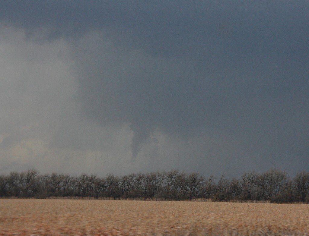
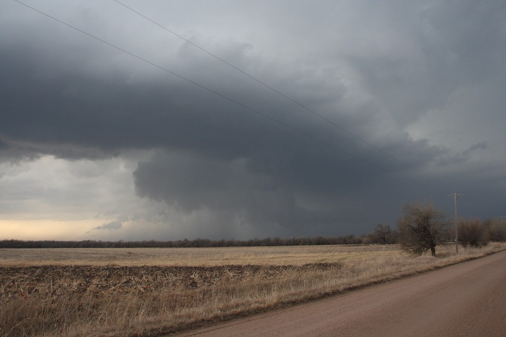
But that’s another story for a different post. Right now, I just want to share a couple images from yesterday’s chase. The moisture was marginal, with dewpoints averaging around 55 degrees up toward the warm front north of Wichita. That’s where we headed, in search of the better helicities. A lot of folks questioned the setup, but it produced. The storm we intercepted put out four tornadoes, though those occurred before we caught up with it. We still saw some nice structure, including a nice wall cloud and a funnel. Check ’em out.

Funnel Cloud

Funnel Cloud

Nice Structure!

Nice Structure!

Severe Weather Forecasting Workshop and Southern Plains Drought

It’s Thursday, and I’m in Louisville, Kentucky, with my buddy Bill. He’s got business here, and I’m taking care of business here on my laptop, and then we head to Norman, Oklahoma, for a severe weather forecasting workshop with Tim Vasquez. At times like this, I’m grateful for the freedom and mobility that come with being a freelance writer. As long as there’s work for me to do, I can do it pretty much anywhere provided I have my laptop and Internet access.

I’ve been hoping to catch a little early-season convective excitement this Saturday. Not sure that’s going to happen, though. The wild card seems to be moisture, but capping may also be a problem. It would be a shame to make the journey to Oklahoma and not see a little decent, Great Plains weather. Of course, that’s not the focus of the trip–the forecasting workshop is–but still, a supercell or two would be nice. Unfortunately, it looks like a cold front will provide the lift that finally busts the cap, and that suggests “linear.”

Sunday is the workshop, so I don’t much care what the weather does that day. I’ll be in class.

Monday may offer another crack at things, and it may be our best opportunity. It’s too far out to say (for that matter, Saturday is still a bit too far off yet to feel either good or bad about it), but assuming that the southern Plains at least get a bit of rain to relieve their dry spell and give the ground a good soaking, moisture may not be the question mark that it is for Saturday’s setup.

Frankly, the current forecast discussion on Stormtrack is the first time I’ve given serious thought to the effect of soil conditions on convection. I had always thought of ground moisture and evapotranspiration as just enhancements to the return flow, not potential deal-breakers. To my mind, a nice, deep low pulling in rich dewpoints from the Gulf of Mexico would more than compensate for dry regional conditions. But more than one seasoned Great Plains storm chaser has looked at the current drought conditions in Texas and Oklahoma and opined skeptically about the chances for 2009 being a good chase year in the West unless the region sees some rain.

Ah, well. The season hasn’t even begun yet, so I’ll take what I can get and hope for better as we move into May and June. Right now, it’s nice to simply see the sun shine, feel fifty-degree temperatures, and know that winter is drawing to a close.

The Wisdom of Not Chasing Storms in February (or, Gee, I’m Glad I Practiced My Sax Instead!)

When it comes to chasing early-season severe systems, I’m getting better about reining myself in. Today was the big test. With a whopper of an H5 jet max–upwards of 120 knots–pushing through northern Kentucky into southern Indiana and Ohio, it was tempting to make the drive down to Xenia and parts thereabouts. True, the whole thing looked to be a massive straight-line wind event, but you never know, right? Particularly when you’ve been cooped up all winter with a nasty case of SDS (Supercell Deficiency Syndrome).

I’m patting myself on the back for not going. In fact, I didn’t chase squat today, not even the grunge that was drifting north from the border and offered at least the possibility of a little lightning. That would have been nice to see in February, but I just couldn’t muster the enthusiasm, and now I’m congratulating myself for my restraint.  The wind event did in fact materialize, but way to the south, down in southern Ohio, Kentucky, Tennessee, and on to the east, and not a solitary tornado report do I see in the whole batch of SPC storm reports. So I’m very glad I managed to ward off the temptation to grasp at straws. Not only am I not presently driving the long 350 miles home, wondering what on earth I was thinking that brought me down there in the first place, but I invested my time into practicing my saxophone, a much more profitable activity.

I worked with my new copy of Emile and Laura De Cosmo’s book The Diatonic Cycle, which arrived today in the mail. It’s fun to work with a practice book again. These days, I do so much of my practicing straight out of my head, and the De Cosmos‘ well-conceived, organized, and interesting approach comes as a welcome new way to work on my scales and keys. It should keep me occupied for a few months as I work my way through all twenty-four major and harmonic minor scales as presented in the book.

Opting for practicing my horn over chasing storms was a smart move today. Yesterday, on the other hand…well, if I lived 500 miles closer to Oklahoma, I’d have been all over yesterday’s severe weather. Sadly, that weather marked the year’s first tornado fatalities. It appears that the sirens weren’t working as a large, violent wedge rototilled the town of Lone Grove, Oklahoma, west of Ardmore, doing EF4 damage and taking fifteen lives. According to reports, some people were caught out in a parking lot. How awful. February is not a time when folks in the Great Plains expect such things, and I’d imagine that many people were caught off guard.

Looking ahead, the Gulf of Mexico appears to be opening up for business in Dixie Alley, but we won’t be seeing any of that moisture this far north again in the foreseeable future.  Tonight we plunge back into snowy conditions. This is, after all, February in Michigan.