COD Severe Weather Symposium

The College of DuPage will host its fourth severe weather conference in Downer’s Grove, IL, on Thursday, November 5, through Saturday, November 7. At $220 a pop for non-students, it’s a pricey proposition. But considering its proximity, Great Lakes chasers may want to invest their shekels. I’ve attended two conferences hosted by Paul Sirvatka et al some years back, and they were very worthwhile. With its cast of preeminent presenters, and topics that include the preliminary findings of Vortex 2, this year promises to be particularly rewarding.

According to the FAQ on the symposium website, “This conference is intended to present the latest in severe weather meteorology to a diverse group of severe weather professionals and students. National conferences present some of this material but time contraints do not allow for a detailed look into the state of the science.”

In the words of COD:

The conference is intended for professional operational and research meteorologists, upper-level undergraduate and graduate students of atmospheric science, storm chasers, severe weather spotters and severe weather enthusiasts. We assume that attendees will have some understanding of severe weather meteorology in order to receive maximum benefit from the severe weather sessions. The focus of the conference is primarily on understanding the latest techniques for severe weather forecasting, the use of meso-scale and storm-scale modelling, physical processes leading to the development of supercells and tornadoes and the effective use of remote sensing in severe thunderstorm evolution and behavior.

This symposium will also highlight some of the preliminary results of VORTEX II.

Rooms at the DoubleTree Hotel and Suites, where the conference will be held, are available for $95 per night and will accommodate four persons.

So there you have it. If you can afford the hotel prices and the cost of the conference, which includes an evening banquet, then this is one event you’ll want to make. I’m contemplating my cash flow, holding my breath, and getting set to register.
Guest Blog: Storm Chaser Andrew Revering on How to Forecast Northwest Flow Events

Regarding tornado potential…with storms moving southeast or even south in some cases, you have to keep in mind that the storm-relative inflow will have to shift in order to maintain a good, dry updraft and support supercellular structure.

Welcome to the first guest post in my new, improved Stormhorn.com blog! I’m pleased to feature Andrew Revering sharing his insights on forecasting northwest flow chase scenarios. Northwest flow seldom produces severe weather; however, some noteworthy tornadoes have occurred in northwest flow. I’m delighted to have Andy share his knowledge about how to forecast the rare chaseworthy setups.

Andy is the proprietor of Convective Development, Inc., and the creator of the unique, enormously powerful F5 Data forecasting data feed and software. A meteorology student both privately and in educational institutions for his whole life, Andy has been a storm chaser for 15 years, four of which he served as a contract storm chaser for KSTP, an ABC-TV affiliate in Minneapolis. Andy started writing weather software in 1996 as a high school senior, developing such programs as AlertMe, APRWeather, WarnMe, StormGuide, AlertMe Pro, SkyConditions, and F5 Data. His current projects include F5 App, F5 Maps, and CellWarn.

During the nearly three years that I’ve used Andy’s F5 Data, I’ve been impressed not only with the power of the product, but also with the knowledge, friendliness, and helpfulness of its creator. Without further preamble, here he is, helping you to get a better handle on…

FORECASTING CHASEWORTHY NORTHWEST FLOW SCENARIOS
By Andrew Revering

The weather pattern known as northwest flow often means cold, stable air and clearing skies, since it comes in the wake of a large synoptic low that has just come through, cleaning the atmosphere of moisture and instability. However, on rare occasions northwest flow can produce very photogenic supercells and even tornadoes.

A northwest flow setup is normally undesirable for storm chasing because severe weather typically occurs in the warm sector before a synoptic system passes, with the jet coming in from the southwest. After the system passes, the shifting jet structure puts you into the northwest flow with limited moisture and instability. With desirable surface features now to your east, you will typically have scrubbed the atmosphere of any good moisture and instability, thereby preventing severe weather from occurring.

However, this is not always the case. A weak ridging pattern, for example, can also produce northwest flow, and it’s possible for weaker surface systems to traverse the flow, bringing in adequate moisture and instability to create a chaseworthy setup.

Regarding tornado potential, the concerns to look at from a forecasting perspective are the same you would consider with a typical deep trough/southwest or westerly flow scenario. Check for adequate deep shear and low-level shear (helicities, 1 km shear vectors, etcetera). You also want to look at the storm-relative inflow. However, with storms moving southeast or even south in some cases, you have to keep in mind that the storm-relative inflow will have to shift to maintain a good, dry updraft and support supercellular structure.

Keep in mind some basics. In order to sustain a single-cell or supercell structure, besides having decent deep-layer shear (40-plus knots at 6 km depth vector), you should also have the environmental wind directions blowing at an angle, with storm motion at roughly ninety degrees from the direction of the environmental winds.

For example, in a classic scenario, storms move due east, with surface winds moving from the south. This allows unstable, warm, moist air to enter the storm on the south side. The storm moves east because the upper-air steering winds are pushing it in that direction. Therefore, when the tower of the storm goes up it gets tilted downwind to the east of the updraft, and rain falls ahead of the storm.

That’s the key point here: rain falls ahead of the updraft. So when you have warm “feeder” air flowing toward the southern side of an eastbound storm, that air can enter the storm unobstructed by precipitation, thus allowing for warm, buoyant air to drive the updraft.

Conversely, if the surface winds came from the east of this same eastbound storm, you’d have storm-relative inflow at 180 degrees. This is BAD for a storm when it comes to producing a tornado, because the incoming air is encountering all of the cold outflow produced by the rain core. It cannot effectively get around this obstacle to feed the updraft. So two problems occur: 1) the warm environmental air gets blocked by the outflow; and 2) the inflow speed decreases, which in turn greatly decreases the low-level shear vector.

Think of it as an extreme. If outflow blocks the environmental winds completely you have zero knots of inflow air into the updraft, which becomes contaminated by the outflow.

In this scenario, the warm air still gets into the storm to feed it, but the storm becomes front-fed, with the warm inflow riding up over the cold outflow. It enters the storm at the mid levels, pushed there by the outflow/gust front, which creates a wedge and causes a shelf cloud to form. The storm then becomes outflow-dominant—linear, multicellular, or some other mode that is unfavorable for tornadoes.

To summarize, then, you need the environmental wind direction to be entering the storm at an angle between, say, 45 and 135 degrees of a storm’s motion to help the storm maintain a super-cellular shape (along with good deep-layer shear and other parameters).

Applying these general principles to a northwest flow event, if your storm motion is southeasterly, south-southeasterly, or southerly, you need storm-relative inflow to be west-southwesterly, westerly or possibly even easterly or east-northeasterly. Since the storm motion is usually going to be southeasterly, the westerly surface options are typically the better choice.

This seems illogical to most chasers. These are not the typical directions you would expect for good inflow; however, they can work well if you have enough instability, moisture, and other of the right ingredients.

When chasing northwest flow storms—or any storms—keep in mind that you want to be on the side of a storm where the environmental inflow is approaching the storm. In a classic setup with an eastbound storm and southerly surface winds, you would look for the updraft base on the south side of the storm (though that can vary from the southeast to southwest side of the storm as well). In a northwest flow scenario, if the surface winds are west-southwest, look for your updraft base on the west-southwest or west side of the storm if its moving south, south-southeast, or southeast. This arrangement can be disorienting to a chaser who doesn’t normally chase storms moving in these directions. In northwest flow, the south or east side of the storm will have few features and present what looks like an outflow-dominant storm, making it easy to miss the tornado on the other side.

Northwest flow storms can be good tornado producers for another reason that I haven’t mentioned yet: they typically bring in cool air in the mid levels. This cool air advection greatly increases instability provided there’s good moisture and instability at the surface. Getting the right surface conditions in place is difficult, but those conditions are the key factor in a good northwest flow setup. Surface moisture and instability combined with unusually cold temperatures in the mid levels can add up to decent instability overall.

Additionally, if the mid levels are cold enough—say, less than -16C at 500mb—you may get a ‘hybrid’ cold core setup to amplify the scenario. However it probably wouldn’t be a true cold core as defined by Jon Davies’ work, given the presence of northwest flow and the likely absence of a significant mid-level cyclone in the area.

Most northwest flow setups occur in June, July, and August, with the peak being in July. These three months account for 85 percent of northwest flow events as studied by Kelly et al, 1978. It is pretty evident that the delay in northwest flow setups during the severe season is due to the lack of adequate moisture in earlier months. In the summer you can get an adundance of moisture that lingers after the passage of a system, allowing for a northwest flow system or even a post-frontal storm or two.

Storm chasers often ignore northwest flow patterns because they typically mean few low pressure centers for convergence and moisture fetch. But while severe weather is rare with northwest flow, it can occur. So keep an eye out. You can easily miss a decent chase scenario by writing it off too quickly.

Year of the Cap Bust

I guess I’m just a slow learner when it comes to technical stuff that involves linear thinking. Sooner or later, though, if I stick with something long enough, I usually emerge more knowledgeable for having done so. Nowhere has this been more true than in storm chasing, an activity which obviously depends heavily on figuring out if and where there will be decent storms to chase.

Seems like I’m constantly being confronted with some new aspect of the atmosphere that I haven’t factored into my forecasting, or that I haven’t factored in as effectively as I needed to. The upside of that, though, is that I wouldn’t even be aware of what I don’t know if I hadn’t learned enough to at least recognize my areas of ignorance. If my forecasts aren’t as expert as those of a trained meteorologist, they’re nonetheless a seven-league bound beyond when I was just beginning to grapple with all those arcane terms and acronyms of convective weather such as SBCAPE, CIN, 0-6km bulk shear, LIs, helicity, and lapse rates, and when the only thing I could do with a skew-T or a hodograph was shake my head in bewilderment.

This has been the year of discovering the 700 mb/12C limit. By “discovering,” I mean through empirical experience, and by “empirical experience,” I mean cap busts. Of course, I’ve endured plenty of cap busts in my development as a storm chaser; I just didn’t understand exactly what was going on, or why the high risk area I was sitting in was producing nothing more than smug blue skies rather than carnivorous supercells.

One memorable day in Iowa drove home the lesson perfectly. MLCIN was supposed to erode by later in the afternoon, and it got to a point where it was eroding, at least according the RUC. With SBCAPE at some ridiculous figure like 7,000 j/kg, I figured that at some point a convective tower would punch through the cap and go absolutely gonzo. Instead, the clouds kept firing up into the nicely sheared environment and then dying, firing and dying, firing and dying. The reason? A 700 mb temperature of around 14C, possibly considerably higher. Lesson learned: it doesn’t much matter what the models have to say about the CIN eroding when you’ve got mid-level temperatures like that.

I experienced another cap bust yesterday, though I can’t feel too bad about it since I had no compelling reason to head out in the first place, the conditions were so marginal. It was interesting to notice that in this situation, the circumstances were reversed: RUC showing my area under very breakable 700 mb temps of around 10C, but with MLCIN creating some concern. However, the CIN appeared to be eroding, and when an SPC mesoscale discussion spotlighted the area I was in, I started feeling happy about having made the drive down to west-central Illinois.

But the CIN started building back in, and by 00Z I found myself socked in under values around -300 j/kg. Not much a parcel of air can do with that, I guess, no matter how big the CAPE is. I turned around and headed home.

A paper by Bunker, Wetencamp, and Schild of the NWS in Rapid City, South Dakota, explores the ins and outs of the 700 mb/12C limit and concludes that it has a limited, conditional application. However, as my buddy Mike Kovalchick pointed out to me, the paper also reveals that only 5 percent of tornadoes within the study period formed when H7 temps exceeded 12C, and virtually no violent (EF4 and EF5) tornadoes occurred above that threshold.

So for practical use in storm chasing, the 12C limit appears to be a very useful rule of thumb. The issue for me then becomes a matter of refining my ability to know when cold air advection will lower the 700 mb temps. But that’s a subject for another blog. I’m tired of thinking. It’s time to go meet my buddy Dewey down in Plainwell and grab a brew at Arie’s. Ciao!

The Summer Pattern Is Setting In

The SPC has placed Michigan and the Great Lakes in a slight risk area for tomorrow. But tornadoes aren’t in the picture. The summer pattern appears to be setting in, with the jet stream moving its headquarters to the US/Canadian border. As far as Michigan is concerned, that’s close enough that we can still expect some decent kinematics here and there. But what we get tends to result in linear MCSs more than supercells and the like.

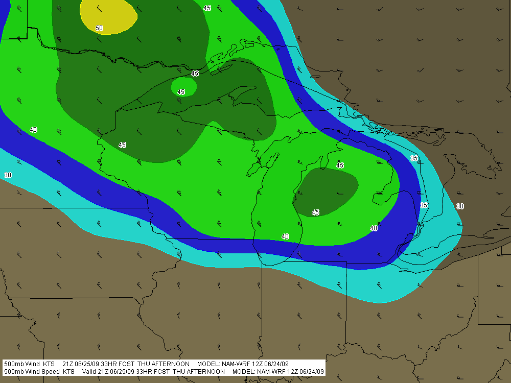
Tomorrow’s SBCAPE should settle in between 2,500 and 3,000 j/kg, with dewpoints in the 70s. That’s certainly an ample supply of convective fuel. And F5 Data shows this for H5 wind speeds at 21Z:

If you can live with northwest flow, that’s not bad. But of course, the underlying winds are all westerly. Once again, Michigan’s energy will get sabotaged by unidirectional winds. How pathetically par for the course! Maybe we’ll get some supercells, but we’re unlikely to see the low-level helicity needed to make them tornado producers. Probably better knock on wood when I say that, because the lake breeze zone can do some funny things with locally backed winds. Overall, though, I think the order of the day will be some nice, burly, ouflowish thunderstorms.

What do I know, though? I’m still pretty green as a forecaster, and I recall a couple years ago when the models showed a unidirectional setup with nothing in the way of helicities, and an F3 tornado ripped through Potterville.

One of the nice things about living in Michigan this time of year–among the many wonderful advantages of this beautiful state–is that we’re prone to get a couple supercellular events when the traditional Tornado Alley of the Great Plains simmers under a titanium cap. Those occasions aren’t anything you can count on, but it’s nice when they happen–for me and my fellow storm chasers, anyway. I suppose other folks here might see things a bit differently.

Remembering May 3, 1999

View from the balcony.

View from the balcony.

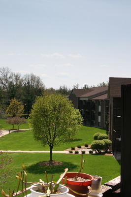
Looking at my recent posts, it dawns on me that it has been a while since I brightened things up with a few photos. The above is a purely gratuitious shot of my small apartment complex in Caledonia, Michigan, taken from my balcony. In the foreground, you can see some of The Kids–that is, my carnivorous plants. They’re long and lank right now from being forced to gather what sun they’ve been able to sitting indoors by the sliding door. April’s temperature fluctuations have permitted only occasional forays outside, but I think that at this point they’re there to stay. Now the bright, direct sun can do its work, strengthening their stems so that in another month or two, new leaves on the pitcher plants should stand up straight and tall.

Actually, the Sarracenia oreophila has already been doing just fine in that regard. Once I took it out of refrigeration, it wasted no time sending up a fine crop of stout, trumpet-shaped leaves. Unfortunately, hornets are drawn to the taller pitcher plants like crazy, and they don’t take kindly to being trapped in them. I’ve had to tape several of the oreo leaves after they collapsed due to hornets chewing holes through the sides in order to escape. I’ve got to believe that hornets aren’t the normal fare for Sarracenias in the wild. My plants occupy a habitat three stories above ground level, not exactly the same kind of ecosystem as an Alabama mountain bog or a southern savannah.

Anyway, as you can see from the photo, today is gorgeous here in Michigan, with temps in the upper sixties–on the cool side of warm. A body can wear shorts or jeans, a T-shirt or a long-sleeve; either works perfectly on a day like today. Me, I’m in shorts. I have no plans to go anywhere, since I’m still a bit wheezy from my cold, but it’s nice to just sit here and look out the window at blue sky, white blossoms, and tress leafing out.

Ironically, this picture-perfect May day is the tenth anniversary of the 1999 Oklahoma Tornado Outbreak. On this date, the infamous Moore/Bridge Creek Tornado tore a path from west of Amber to Midwest City, taking 36 lives and becoming the last tornado to be rated an F5 under the original, now passe Fujita scale. A wind max in this tornado of 301 mph, give or take 20 mph, recorded by the Doppler on Wheels (DOW) remains the fastest tornado wind ever measured to date, placing the Bridge Creek tornado at the upper end of even the most extreme tornadoes. Powerful as it was, another monstrous tornado which plowed through the town of Mulhall that same day may have been even stronger.

It’s hard to fathom winds of that velocity. It’s faster than most BB guns. To help you visualize such a wind speed, if a piece of lumber was blowing at you at 301 mph from a house disintegrating 450 feet away, you’d have approximately one second to duck. Granted, the DOW reading was 105 feet above ground, and the surface winds were likely to have been somewhat slower. But I doubt that information would have been very reassuring to residents of Bridge Creek that day as they watched the storm bearing down on them.

What a cheery thought. I think I’ll return to today’s bright sunshine and enjoy it. Storm season is at hand, my cold is on its way out, and I hope to get out to the Plains in another couple of weeks and chase some supercells. But for now, it’s May 3 and the day is beautiful here in Michigan. Who could ask for more?

Chicken Soup for the Solo

The meds that the doc prescribed for me seem to finally be working their mojo. I’m still coughing, but it’s no longer a painful cough, and yesterday’s feverishness has passed. Today I went out and bought a bunch of Amish chicken and a whole passel of assorted veggies and rice, and I made up a huge potful of chicken soup. I’ve heard more than one person tell me that the old wive’s tale is true: homemade chicken soup has a wholesome, curative property. I believe it. People breathing their last gasp have been known to revive at a mere whiff of my chicken soup.

Anyway, it’s been a week since I’ve played my horn, and in the interrim, I’ve felt so lousy that I haven’t even thought about it. As for storm chasing, ha. Good thing I didn’t go down to Tornado Alley last weekend with Bill and Tom–not only would I have been miserable, but by now they would be, too.

Storms have been lighting up the Plains pretty much all week. My friend Kurt Hulst was out in Oklahoma yesterday with his pal Nick, and he posted some nice pics on his blog. I’m assuming he caught the supercells in northern Texas earlier today as well. Can’t wait to see those photos.

Of course, I’ve been out of the action. Out of practice on my sax, out of the picture for chasing storms. In another couple of days, though, I should be ready to rumble. I just hope the weather feels the same way. My head is finally back on my shoulders only barely enough that I might start giving a rip about the forecast models, and maybe even be able to make some sense out of them again.

Enough for now. Tornadoes can wait. Right now, a bowlful of chicken soup is calling my name. If I eat enough, I might find myself in good enough shape by tomorrow to blow a few notes on my saxophone. Chicken soup for the solo. I like that idea.

First Storm Chase, 2009

What a memorable way to kick off storm season 2009! Yesterday, I chased supercells in Kansas with my buddy, Bill Oosterbaan, and today we attended Tim Vasquez’s severe weather forecasting workshop in Norman, Oklahoma. I’m writing this post from a Best Western Hotel maybe a mile north of where the 1999 Moore tornado crossed I-35. All in all, not a bad past couple of days for a lad from Michigan.

Yesterday’s chase began with a visit to Picher, Oklahoma. The southern portion of this tiny town got wiped out last spring by an EF-4 tornado. Today, a year later, that desolate landscape shows scant chance of recovery. It’s a sobering place to visit.

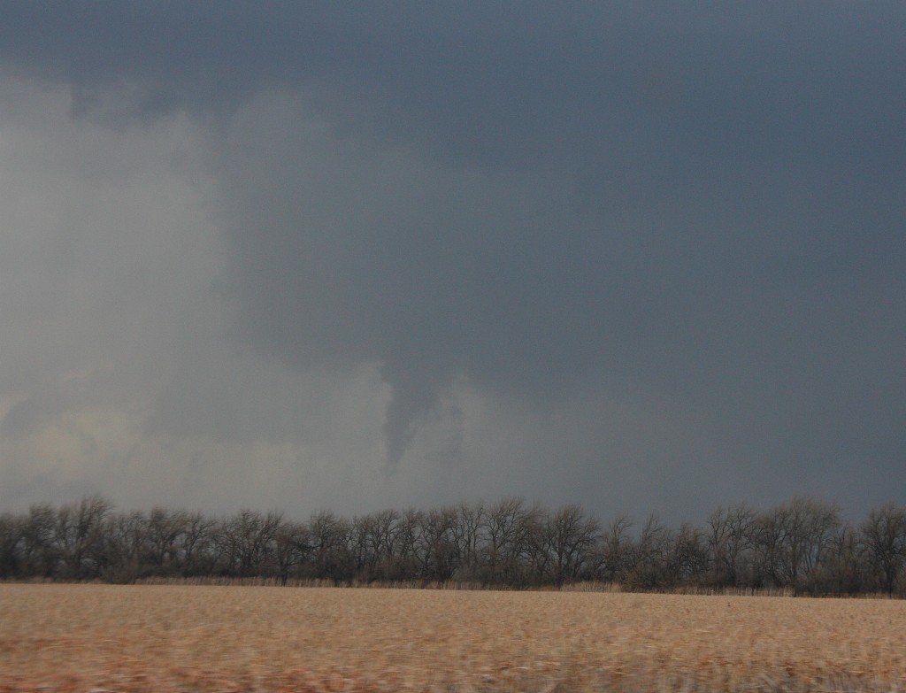
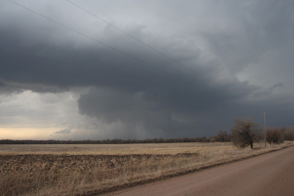
But that’s another story for a different post. Right now, I just want to share a couple images from yesterday’s chase. The moisture was marginal, with dewpoints averaging around 55 degrees up toward the warm front north of Wichita. That’s where we headed, in search of the better helicities. A lot of folks questioned the setup, but it produced. The storm we intercepted put out four tornadoes, though those occurred before we caught up with it. We still saw some nice structure, including a nice wall cloud and a funnel. Check ’em out.

Funnel Cloud

Funnel Cloud

Nice Structure!

Nice Structure!