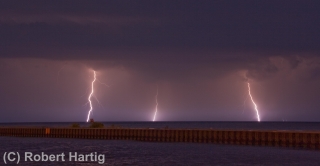
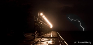
Lightning at the South Haven Pier

Yesterday’s slight risk for Michigan looked more impressive in the models than it did up close and personal. With dewpoints as high as a sultry 78 degrees Fahrenheit in Caledonia (courtesy of my Kestrel 4500 weather meter), MLCAPE upwards of 3,500 J/kg, and 40 knots at 500 millibars, the ingredients were all present for a decent severe weather event. Backing surface flow even suggested the possibility of tornadic spin-ups, though winds at the surface were weak.

For all that, the storms when they finally arrived were pretty garden variety, with one exception: the lightning was absolutely spectacular, a

nonstop flickerfest bristling with CGs. The lines rolled across Lake Michigan in two rounds. Thanks to some good input from Ben Holcomb, I chose to set up shop at the South Haven beach, a great strategic location, arriving there in plenty of time to intercept round one. Kurt Hulst met me there, and we got our live streams going and tripoded our cameras as the northern end of the line bore down on us.

It was too dark to see the shelf cloud very distinctly. I tried to capture it with my camcorder; I haven’t viewed the footage yet, so I don’t know how it turned out, but I soon realized that I’d be better off working with my still camera, which I got mounted right about the time that the gust front arrived. The rain was near-instantaneous, escalating within moments from errant droplets to a horizontal sheet, and I scurried back to my car while collapsing my tripod as fast as I could.

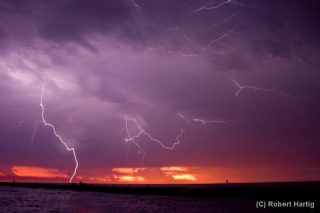
What a great light show! After a lot of teasers this year, I finally got a chance to get some good lightning shots, particularly as the storm moved off to the east. With CGs ripping through the air over South Haven, anvil crawlers lacing the sky overhead, and now and then a brilliant bolt tracing a path from the sky to the lake across the canvas of a molten sunset, yesterday evening was a lightning photographer’s dream. Kurt is a great hand in that regard, and he captured some fantastic images. But for once, even I managed to get some shots I’m pleased with. Here are some of my better ones. Click on them to enlarge them.

As the storm moved on, a good number of people returned to the beach with their cameras to capture the amazing sunset and the lightning display. Storm chasers aren’t the only ones with an eye for the drama that the sky provides!

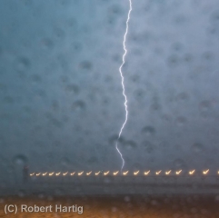
Some of my photos were taken later on, as the second line of storms was moving toward the shore. I’m particularly pleased with my shot of a lightning bolt off to the right of the pier; it’s a moody, mysterious image, and I intentionally left plenty of dark space at the bottom left.

I might add that the pics with raindrops all over the foreground were taken from my car during the height of the first storm. While I’d of course prefer nice, clear images, I don’t mind the drops. They lend a somewhat Impressionistic feel to the photos. At least, that’s what I tell myself.
April 14-16 Southeast Tornado Outbreak: Thoughts and Images

There are times when the sight of a high risk sickens rather than excites me, and Saturday was one of those days. It’s one thing when severe storms occur in the Great Plains where the population is sparse, but when a swarm of tornadoes roars across an area punctuated with cities and towns, all I can think is, “Oh no. All those people!” Such was the case with last week’s horrendous three-day tornado outbreak across the South and East.

The outbreak commenced Thursday in Oklahoma, Kansas, and Arkansas, with a preliminary figure of 27 tornadoes reported.* The action ramped up Friday in Louisiana, Kentucky, Missouri, Illinois, Mississippi, Alabama, and Georgia, with an initial tally of 120 tornadoes. Day three was the worst of all, with yet another 120 reported tornadoes slashing across the populous, densely forested Southeast and East from South Carolina to as far north as Pennsylvania. Hardest hit was North Carolina, where large and powerful tornadoes ripped through Raleigh and other communities. Twenty-two lives were lost, 11 of them when a three-quarter-mile-wide, EF3 monster carved a 19-mile path across Bertie County. Another six died in Virginia. And in its previous two days, the outbreak claimed seven lives in Arkansas, seven in Alabama, two in Oklahoma, and one in Mississippi.

In all, Saturday’s tornadoes were North Carolina’s most lethal since 1984, when 42 died. And regionally, Friday and Saturday were the worst tornado outbreak in the Southeast since the Super Tuesday Outbreak of February 5–6, 2008, when 87 tornadoes killed 57 people in four Dixie Alley states.

But my point in writing this article isn’t to provide yet another news story on the disaster. Rather, it’s to share my feelings as I watched it unfold. With some truly amazing video coming in from chasers in Oklahoma, the first day was fascinating. Day two, watching tornadic supercells crawl across Mississippi and Alabama on the radar was unnerving; I hoped nothing bad would happen down there in the South, but I knew better. On day three, when I saw the high risk go up in North Carolina, my heart sank.

When it comes to armchair chasing, I’m moderate in my habits. If I can’t actually be out chasing, I often opt for a more constructive use of my time than watching the radar and gnawing my knuckles. This time, though, I couldn’t help watching. At first the line of storms looked mean but not terribly alarming. As the storms headed east, though, they began to organize and strengthen, and circulations began to show on radar. Strong circulations, a whole line of them, stretching from northern South Carolina up into Maryland and Virginia. And the tornado reports began filtering in. These storms didn’t merely appear to be impacting towns–they were.

I watched one monster chew through Raleigh, thinking, “No way!” Then came the videos on YouTube, one of them by chasers at unnervinglyclose range, and I knew. No one was dodging the bullet this time. Neighborhoods were being pulverized and people were dying.

With fiscal conservatives recently wanting to slash the budget of the National Weather Service, all one has to do is witness a scenario like last weekend’s in order to realize the supreme lunacy of such a move. Tornado season is just getting started. More is on the way. Bad as last week was, we could yet see worse. How smart is it to pull the rug out from under our national weather warning system at precisely the time of year when its optimal service is most needed?

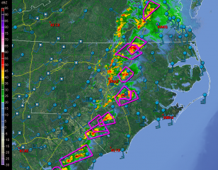
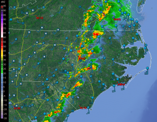
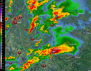
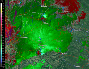
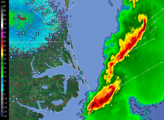
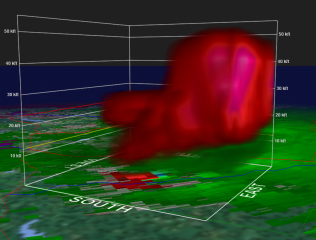
But I digress. Here are a few GR2AE radar grabs of the North Carolina supercells. Storm motions were to the northeast. The rest tells its own story if you know what you’re looking at.

First, here’s are a couple macroscopic views.

Next, I’ve zoomed in on the Raleigh radar to  cross-check reflectivity and storm-relative velocity on a couple supercells.

The final image was taken after the storms had moved out to sea. It shows a couple of northern line-end vortices that I found interesting and thought you might too.

____________________
* All numbers reflect preliminary reports at the time of this post’s publication. Final statistics will likely be different.

Dixie Alley Lights Up

Severe storms have been pushing through Dixie Alley this afternoon and evening, fed by dewpoints in the mid 60s to lower 70s and propped by bulk shear in the 60-70kt range. The action has been largely in Louisiana, where tornado warnings have been ongoing for several hours and tornado damage has been reported northwest of Atlanta.

Typical of southeastern storms, these ones look pretty HP-ish, real drenchers. They’ve waned in intensity from earlier, but they’re still dangerous storms, and one of them  in East Carroll County is presently tornado-warned.

Here’s a GR2AE volume scan from the Shreveport radar depicting storm-relative velocity at 2107Z. Click on the image to enlarge it. You can see a pronounced couplet, indicating strong base-level rotation. I believe this was in fact the storm responsible for the tornado report, although two others in the same region displayed potent mesocyclones. More tornado reports may turn up from that part of Louisiana before the night is through.

Troughy Weather for Next Week

Here on the back end of a 996 mb low, dry Canadian air has dropped the moisture along with the heat in Caledonia, Michigan. We’re presently socked in with clouds, and temperatures are supposed to peak at just 65 degrees. It feels a lot like fall outside.

This latest cold front has meant business, and to me it signifies the arrival of autumn’s transitional weather pattern–a time when the upper atmosphere begins to cool and conditions become more conducive to bouts of severe storms.

Our next round of stormy weather may be arriving by next weekend. Granted, it’s pretty early to be looking so far ahead, but the SPC has been eyeballing the next trough in their long-range discussions with a good amount of confidence. Seems like a question not of whether something will happen, but when.

Not having access to many of the SPC’s forecasting tools, I have to go by what’s available to me. The GFS and Euro both depict a pretty deep trough. The GFS, typically, wants to move it along faster than the Euro, but both models agree that there will be something there to move. Both also show a robust surface low developing and drawing in dewpoints in the mid 60s. The northern plains may get hammered later this coming week. By the weekend, Michigan may get a crack at some severe storms. Or not. The crystal ball is murky this far out, and as always, the caveat is, we’ll find out when we find out.

Whatever happens, it’s nice to think that the weather machine may be lurching out of the summer doldrums and getting set to ramp up the action. September furnishes some nice opportunities for taking photos of squall lines blowing in at the lakeshore. Maybe this will be one such occasion. Maybe it’ll be even better than that. It’s not premature to cross our fingers.