Here Comes the Summer Pattern

Sumer is icumen in,
Loudly sing, cuckoo!
Grows the seed and blows the mead,
And springs the wood anew;
Sing, cuckoo!
Ewe bleats harshly after lamb,
Cows after calves make moo;
Bullock stamps and deer champs,
Now shrilly sing, cuckoo!
Cuckoo, cuckoo
Wild bird are you;
Be never still, cuckoo!

Right. It looks like we’re about to have our hands full, what with bleating ewes, cows making moo, and so on. There are, however, some things that the old folk song fails to mention. The polar jet lifting north, for instance. Weakening mid-level winds. Temperatures at 700 mb heating up, with the 12 degree centigrade threshold expanding across the southern and central plains and ushering in the era of capping. I don’t know why the ancient songwriter didn’t address these matters. They’re as much a part of sumer–that is to say, summer–as stamping bullocks.

Here in Caledonia, yesterday was hot and today promises to be even hotter, around 95 degrees, before a cold front blows through tonight and brings relief. After that, we look to be in for a bout of unsettled weather. I’ll take it, even though it may inconvenience at least one outdoor gig I’ll be playing this weekend.

The summer weather pattern is on the way, putting the damper on storm chasing in the southern and central plains. Considering how devastatingly active this spring has been, that’s probably a good thing. I doubt that the people in towns such as Joplin, Missouri, will lament this season’s passing. As for those who chased storms in Dixie Alley and the southern plains–and there were more chasers than ever this year–you certainly got your fill of action, and some of you saw far more than you cared to. There are some amazing stories that have come out of the storm chasing community, and my hat is off to those of you who stepped in to help in tornado-stricken areas.

This was the worst of all seasons to be sidelined due to financial constraints, but that’s how it has been with me and with others who have taken a hit in the pocketbook from this rotten economy. I’m frankly happy to see the crest of storm season 2011 passing; I much prefer to occupy my mind with more productive thoughts than fretting over what I’m missing.

In any event, the playground is shifting northward. It’s not there quite yet, but it’s on the way. Troughs that had been digging deep into the southern plains are now beginning to ripple across the northern tier and Canada, and lately, mesoscale convective systems have been cropping up regularly in the SPC discussions. Those are the specialty of the state where I live.
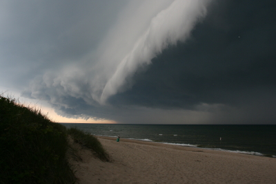
If there’s any advantage to living in the Great Lakes, it’s that we’re close enough to the summer jet stream that it can still dip down out of Canada into our neck of the woods. And while northwest flow isn’t exactly your classic chase scenario, it can deliver some occasional surprises. Illinois in particular has gotten some whopping summer tornadoes–and for those of you who don’t chase east of the Mississippi, I don’t mind telling you that central and northern Illinois is fabulous chase territory. Also, closer to home, even garden variety arcus clouds are sublime to watch sweeping in at the Lake Michigan shoreline.

For better or worse, sumer is icumen in and storm season is winding down. Most people aren’t sorry for the change. But most people don’t view storms the way that storm chasers do. I guess we’re a bit cuckoo.
Oldies But Goodies

Sorry–I seem to have let an entire week slip by without posting. Many bloggers have a knack for slapping out short, cogent posts in 15 minutes or so, but that’s not a gift of mine. Just about every post takes me several hours to write, particularly the ones that include musical exercises. So when I have other things packing my schedule, the prospect of sitting down and creating a post can seem daunting.

That has been the case this week. Could be a streak of just plain old laziness somewhere in the mix, too, but mainly, these past few days have been busy ones. My brothers Pat and Terry arrived for a two-week visit Monday, so family has been a priority. And work still goes on, regardless–gotta make a living.

Today my bros, my sister, Diane, and I headed to Newaygo, rented some kayaks, plopped them into the Muskegon River, and spent the afternoon taking a delightful 6-mile drift with the current. The Muskegon is a surpassingly beautiful stretch of water. I saw three bald eagles soaring overhead, slews of large turtles sunning themselves on logs, several kingfishers, a green heron, and brilliant red cardinal flowers rimming the banks in swampy areas. Altogether it was a most satisfying day.

But of course, as I said, I haven’t had time to write. So I figured that instead, I’d refer you to a couple of links to archived articles. The first is one I wrote one year ago, titled “Will I Ever Become a Good Jazz Improviser?” The second article is for storm chasers by guest poster Andrew Revering of Convective Development, Inc., on how to forecast severe weather during northwest flow.

I hope you enjoy the articles, and will find your journey back to last August’s posts profitable and refreshing. As for me, I’m tired. It has been a long day, it’s now after midnight, and I’m going to bed. G’night!

Guest Blog: Storm Chaser Andrew Revering on How to Forecast Northwest Flow Events

Regarding tornado potential…with storms moving southeast or even south in some cases, you have to keep in mind that the storm-relative inflow will have to shift in order to maintain a good, dry updraft and support supercellular structure.

Welcome to the first guest post in my new, improved Stormhorn.com blog! I’m pleased to feature Andrew Revering sharing his insights on forecasting northwest flow chase scenarios. Northwest flow seldom produces severe weather; however, some noteworthy tornadoes have occurred in northwest flow. I’m delighted to have Andy share his knowledge about how to forecast the rare chaseworthy setups.

Andy is the proprietor of Convective Development, Inc., and the creator of the unique, enormously powerful F5 Data forecasting data feed and software. A meteorology student both privately and in educational institutions for his whole life, Andy has been a storm chaser for 15 years, four of which he served as a contract storm chaser for KSTP, an ABC-TV affiliate in Minneapolis. Andy started writing weather software in 1996 as a high school senior, developing such programs as AlertMe, APRWeather, WarnMe, StormGuide, AlertMe Pro, SkyConditions, and F5 Data. His current projects include F5 App, F5 Maps, and CellWarn.

During the nearly three years that I’ve used Andy’s F5 Data, I’ve been impressed not only with the power of the product, but also with the knowledge, friendliness, and helpfulness of its creator. Without further preamble, here he is, helping you to get a better handle on…

FORECASTING CHASEWORTHY NORTHWEST FLOW SCENARIOS
By Andrew Revering

The weather pattern known as northwest flow often means cold, stable air and clearing skies, since it comes in the wake of a large synoptic low that has just come through, cleaning the atmosphere of moisture and instability. However, on rare occasions northwest flow can produce very photogenic supercells and even tornadoes.

A northwest flow setup is normally undesirable for storm chasing because severe weather typically occurs in the warm sector before a synoptic system passes, with the jet coming in from the southwest. After the system passes, the shifting jet structure puts you into the northwest flow with limited moisture and instability. With desirable surface features now to your east, you will typically have scrubbed the atmosphere of any good moisture and instability, thereby preventing severe weather from occurring.

However, this is not always the case. A weak ridging pattern, for example, can also produce northwest flow, and it’s possible for weaker surface systems to traverse the flow, bringing in adequate moisture and instability to create a chaseworthy setup.

Regarding tornado potential, the concerns to look at from a forecasting perspective are the same you would consider with a typical deep trough/southwest or westerly flow scenario. Check for adequate deep shear and low-level shear (helicities, 1 km shear vectors, etcetera). You also want to look at the storm-relative inflow. However, with storms moving southeast or even south in some cases, you have to keep in mind that the storm-relative inflow will have to shift to maintain a good, dry updraft and support supercellular structure.

Keep in mind some basics. In order to sustain a single-cell or supercell structure, besides having decent deep-layer shear (40-plus knots at 6 km depth vector), you should also have the environmental wind directions blowing at an angle, with storm motion at roughly ninety degrees from the direction of the environmental winds.

For example, in a classic scenario, storms move due east, with surface winds moving from the south. This allows unstable, warm, moist air to enter the storm on the south side. The storm moves east because the upper-air steering winds are pushing it in that direction. Therefore, when the tower of the storm goes up it gets tilted downwind to the east of the updraft, and rain falls ahead of the storm.

That’s the key point here: rain falls ahead of the updraft. So when you have warm “feeder” air flowing toward the southern side of an eastbound storm, that air can enter the storm unobstructed by precipitation, thus allowing for warm, buoyant air to drive the updraft.

Conversely, if the surface winds came from the east of this same eastbound storm, you’d have storm-relative inflow at 180 degrees. This is BAD for a storm when it comes to producing a tornado, because the incoming air is encountering all of the cold outflow produced by the rain core. It cannot effectively get around this obstacle to feed the updraft. So two problems occur: 1) the warm environmental air gets blocked by the outflow; and 2) the inflow speed decreases, which in turn greatly decreases the low-level shear vector.

Think of it as an extreme. If outflow blocks the environmental winds completely you have zero knots of inflow air into the updraft, which becomes contaminated by the outflow.

In this scenario, the warm air still gets into the storm to feed it, but the storm becomes front-fed, with the warm inflow riding up over the cold outflow. It enters the storm at the mid levels, pushed there by the outflow/gust front, which creates a wedge and causes a shelf cloud to form. The storm then becomes outflow-dominant—linear, multicellular, or some other mode that is unfavorable for tornadoes.

To summarize, then, you need the environmental wind direction to be entering the storm at an angle between, say, 45 and 135 degrees of a storm’s motion to help the storm maintain a super-cellular shape (along with good deep-layer shear and other parameters).

Applying these general principles to a northwest flow event, if your storm motion is southeasterly, south-southeasterly, or southerly, you need storm-relative inflow to be west-southwesterly, westerly or possibly even easterly or east-northeasterly. Since the storm motion is usually going to be southeasterly, the westerly surface options are typically the better choice.

This seems illogical to most chasers. These are not the typical directions you would expect for good inflow; however, they can work well if you have enough instability, moisture, and other of the right ingredients.

When chasing northwest flow storms—or any storms—keep in mind that you want to be on the side of a storm where the environmental inflow is approaching the storm. In a classic setup with an eastbound storm and southerly surface winds, you would look for the updraft base on the south side of the storm (though that can vary from the southeast to southwest side of the storm as well). In a northwest flow scenario, if the surface winds are west-southwest, look for your updraft base on the west-southwest or west side of the storm if its moving south, south-southeast, or southeast. This arrangement can be disorienting to a chaser who doesn’t normally chase storms moving in these directions. In northwest flow, the south or east side of the storm will have few features and present what looks like an outflow-dominant storm, making it easy to miss the tornado on the other side.

Northwest flow storms can be good tornado producers for another reason that I haven’t mentioned yet: they typically bring in cool air in the mid levels. This cool air advection greatly increases instability provided there’s good moisture and instability at the surface. Getting the right surface conditions in place is difficult, but those conditions are the key factor in a good northwest flow setup. Surface moisture and instability combined with unusually cold temperatures in the mid levels can add up to decent instability overall.

Additionally, if the mid levels are cold enough—say, less than -16C at 500mb—you may get a ‘hybrid’ cold core setup to amplify the scenario. However it probably wouldn’t be a true cold core as defined by Jon Davies’ work, given the presence of northwest flow and the likely absence of a significant mid-level cyclone in the area.

Most northwest flow setups occur in June, July, and August, with the peak being in July. These three months account for 85 percent of northwest flow events as studied by Kelly et al, 1978. It is pretty evident that the delay in northwest flow setups during the severe season is due to the lack of adequate moisture in earlier months. In the summer you can get an adundance of moisture that lingers after the passage of a system, allowing for a northwest flow system or even a post-frontal storm or two.

Storm chasers often ignore northwest flow patterns because they typically mean few low pressure centers for convergence and moisture fetch. But while severe weather is rare with northwest flow, it can occur. So keep an eye out. You can easily miss a decent chase scenario by writing it off too quickly.

Introducing…THE NEW THEME!

IT’S HERE!

The long-awaited face lift for Stormhorn.com has arrived at last!

Yaaaaaaaayyyyyyyy!!!!!!!!!!

Thanks to the creativity, coding expertise, online marketing savvy, and hard work of my beautiful and brilliant (and thoroughly geeky) lady friend, Lisa, my blog has acquired not only an all-new look, but greater flexibility and immensely expanded capabilities. Lisa built this new theme for me from scratch. It will take time for me to learn how to exploit all of its many features, and there may be a few bugs to work through in the process. So be patient. New pages will be added, and sundry plug-ins and widgets affixed.

Just as it stands, though, I’m extremely excited about the new format, and I hope you’ll like it, too. Please feel free to share your feedback with me.

And allow me to give Lisa a plug. If you’re looking for help with website design, programming, custom themes, WordPress, social network marketing, or anything computer- or Internet-related, do yourself a big favor and contact Lis. She is the proprietor of Studio 727 Ltd., and she’s extremely knowledgeable. Better still, she’s capable of communicating in plain words with those of us who aren’t all that technically savvy. In fact, that’s part of her mission: to help make life easier for us ordinary mortals who rely on computers and the Internet but struggle with all the technical gobbledegook.

If you have a project or could use a sharp but down-to-earth consultant, shoot Lis an email at lisa@studio727ltd.com. You can thank me later for recommending her to you.

With the new theme now installed, I’m finally ready to move on an idea I’ve been cultivating for a while now. I’m excited to start bringing you periodic guest articles from the worlds of jazz and storm chasing. My lineup is already forming, and I think you’ll like what you find. I haven’t yet decided how often I’ll feature guest bloggers. Obviously, their availability will be a big determinant.

For now, I’m extremely pleased to say that the first guest blog is already written, and it’s excellent. Storm chaser Andrew Revering, weather forecasting software designer and proprietor of Convective Development, Inc., has done a stellar job of sharing his insights on northwest flow events. I plan to publish his article later this week, so stay tuned. And for my jazz readers, I anticipate having something for you as well before long, so don’t worry. You won’t be neglected, I promise!

That’s it for now. If you’ve enjoyed my blog to this point, then I trust you’ll like the new Stormhorn.com all the more as it continues to develop. Again, please feel free to share your thoughts.

–Bob

The Summer Pattern Is Setting In

The SPC has placed Michigan and the Great Lakes in a slight risk area for tomorrow. But tornadoes aren’t in the picture. The summer pattern appears to be setting in, with the jet stream moving its headquarters to the US/Canadian border. As far as Michigan is concerned, that’s close enough that we can still expect some decent kinematics here and there. But what we get tends to result in linear MCSs more than supercells and the like.

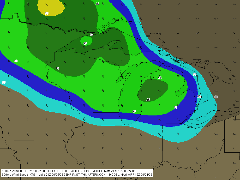
Tomorrow’s SBCAPE should settle in between 2,500 and 3,000 j/kg, with dewpoints in the 70s. That’s certainly an ample supply of convective fuel. And F5 Data shows this for H5 wind speeds at 21Z:

If you can live with northwest flow, that’s not bad. But of course, the underlying winds are all westerly. Once again, Michigan’s energy will get sabotaged by unidirectional winds. How pathetically par for the course! Maybe we’ll get some supercells, but we’re unlikely to see the low-level helicity needed to make them tornado producers. Probably better knock on wood when I say that, because the lake breeze zone can do some funny things with locally backed winds. Overall, though, I think the order of the day will be some nice, burly, ouflowish thunderstorms.

What do I know, though? I’m still pretty green as a forecaster, and I recall a couple years ago when the models showed a unidirectional setup with nothing in the way of helicities, and an F3 tornado ripped through Potterville.

One of the nice things about living in Michigan this time of year–among the many wonderful advantages of this beautiful state–is that we’re prone to get a couple supercellular events when the traditional Tornado Alley of the Great Plains simmers under a titanium cap. Those occasions aren’t anything you can count on, but it’s nice when they happen–for me and my fellow storm chasers, anyway. I suppose other folks here might see things a bit differently.