Intercepting the March 2, 2012, Palmyra-Henryville-Marysville, Indiana, Tornado

Now, while my video from Friday’s chase is uploading to YouTube, is a good time for me to write my account of how things transpired down in southern Indiana.

The phrase “historic event” rarely describes something good when applied to severe weather. March 2 may qualify as a historic event. The current NOAA tally of tornado reports stands at 117; the final number, while likely smaller once storm surveys have been completed and multiple reports of identical storms have been consolidated, may still set Friday’s outbreak apart as the most prolific ever for the month of March. Whether or not that proves true, Friday was unquestionably a horrible tornado day that affected a lot of communities from southern Indiana and Ohio southward.

The Storm Prediction Center did an excellent job of keeping track of the developing system, highlighting a broad swath of the eastern CONUS for a light risk in the Day Three Convective Outlooks and upgrading the area on Day Two to a moderate risk. On Day One, the first high risk of 2012 was issued for a four-state region that took in southern Indiana and southwest Ohio, most of Kentucky, and north-central Tennessee–a bullseye in the middle of a larger moderate risk that cut slightly farther north and east and swept across much of Mississippi and Alabama as well as northwestern Georgia.

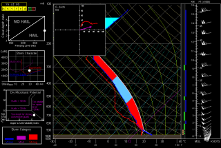
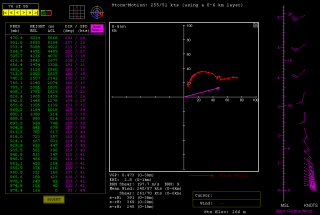
The SPC and NWS offices weren’t the only ones keeping vigilance. Storm chasers across the country were watching the unfolding scenario, among them being my good friend Bill Oosterbaan and me. Here are the February 29 00Z NAM model sounding and hodograph for March 2, forecast hour 21Z, at Louisville, Kentucky. (Click on the images to enlarge them.) With MLCAPE over 1,800 J/kg, 0-6 km bulk shear of 70 knots, and 1 km storm-relative helicity at 245 m2/s2, the right stuff seemed to be coming together. By the time the storms actually started firing, those figures were probably conservative, particularly the low-level helicity, which I recall being more in the order of 400 m2/s2 and up. Simply put, the region was going to offer a volatile combination of moderate instability overlaid by a >50-knot low-level jet, with a 100-plus-knot mid-level jet core ripping in.

I had my eyes set on southeastern Indiana. The problem with that area is, it’s lousy chase terrain along the Ohio River, and it doesn’t improve southward. If there was an ace-in-the-hole, it was Bill’s knowledge of the territory, gleaned from his many business trips to Louisville.

We hit the road at 7:15 that morning, stopping for half an hour in Elkhart so Bill could meet with a client and then continuing southward toward Louisville. Bill was of a mind to head into Kentucky, where the EHIs and CAPE were higher; I was inclined to stay farther north, closer to the jet max, the warm front, and, presumably, stronger helicity. But either choice seemed likely to furnish storms, and since Bill was driving, has good instincts, and knows and likes western Kentucky, I was okay with targeting the heart of the high risk rather than its northern edge.

But that plan changed as we drew near to Louisville. By then, storms were already firing, and one cell to our southwest began to take on a classic supercellular appearance. Bill was still for heading into Kentucky at that point, but after awhile, a second cell matured out ahead of the first one. We now had two beautiful, classic supercells to our southwest, both displaying strong rotation. It was a case of the old adage, “A bird in the hand is worth two in the bush”–except in this case, there were two birds, back to back. And I-64 would give us a clear shot at both of them.

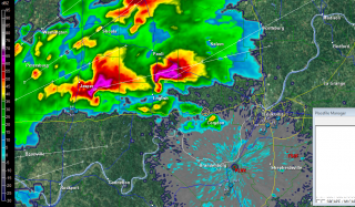
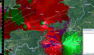
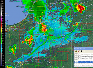
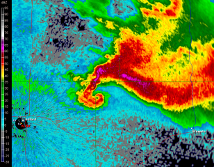
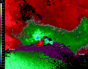
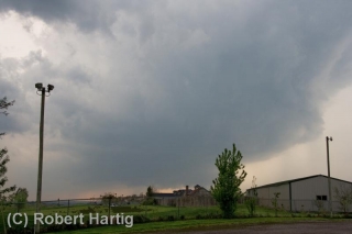
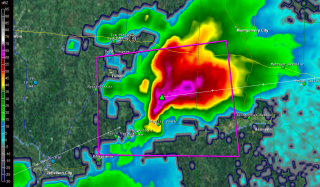
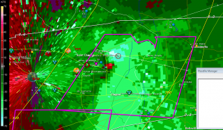
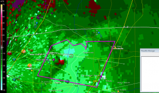
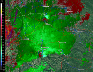
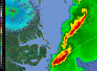
So west we went, and into chase mode. At the Corydon exit, we caught SR 135 north, headed for an intercept with the first supercell. The two radar captures show the base reflectivity and SRV shortly after we began heading up the state road.

A few miles south of Palmyra, we got our first glimpse of a wall cloud maybe four miles distant. That’s all there was at that point, and the hilly, forested terrain afforded less-than-optimal viewing. Within a minute or two, we emerged into an open area just in time to see a funnel descend from the cloud. Tornado!

The sirens were sounding in Palmyra, providing an eldritch auditory backdrop to the ropy funnel writhing in the distance as we drove through town. The tornado went through various permutations before expanding into a condensation cone revolving like a great auger above the treeline. It was travelling fast–a good 60 miles an hour, at a guess. As we sped toward it, the condensation hosed its way fully to the ground and the tornado began to broaden. It crossed the road about a half-mile ahead of us, continuing to intensify into what appeared to be a violent-class tornado with auxiliary vortices wrapping around it helically.

Shortly after, Bill and I came upon the damage path. We pulled into a side road lined with snapped trees, amid which a house stood, somehow untouched except for a number of peeled shingles. The tornado loomed over the forest beyond, an immense, smoky white column wrapping around itself, rampaging northeastward toward its fateful encounters with Henryville and Marysville.

The time was just a few minutes before 3:00 eastern time. While I prepared and sent a report to Spotter Network, Bill turned around and headed back south. We had another storm to think about, and it was closing in rapidly. It wouldn’t do to get caught in its way.

Back in Palmyra, we headed west and soon came in sight of another wall cloud. This storm also reportedly went tornadic, but it never produced during the short time that we tracked with it. We lost it north of Palmyra; given the topography, the roads, and the storm speed, there was no question of chasing it.

From that point, we headed south across the river into Kentucky to try our hand at other storms, but we saw no more tornadoes, nor, for that matter, much in the way of any serious weather. Not that there weren’t plenty more tornado-warned storms; we just couldn’t intercept them, and after giving it our best shot, we turned around and headed for home.

Lest I forget: my worst moment of the chase came when I couldn’t locate my video of the tornado in my camera’s playback files. It seemed unfathomable that I could have horribly botched my chance to finally capture decent tornado footage with my first-ever hi-def camera. After being miserably sidelined during last year’s record-breaking tornado season, the thought that I had somehow failed to record this day’s incredible intercept just sickened me. Fortunately, there were no sharp objects readily available; and better yet, the following morning I discovered that I had simply failed to scroll up properly in the playback mode. All my video was there, and it was spectacular. Here it is:

My excitement over the video was offset by reports of just how much devastation this tornado caused eighteen miles northeast of where it crossed the road in front of Bill and me. Henryville, obliterated. Marysville, gone. Eleven lives lost in the course of that monster’s fifty-two-mile jaunt. And similar scenarios duplicated in other communities across the South and East. The death toll for the March 2 outbreak presently stands at around forty.

In the face of a mild winter and an early spring, Friday was the inauguration for what may be yet another very active severe weather season east of the Mississippi. We can only hope that there will be no repeats of last year’s wholesale horrors. May God be with those have lost loved ones and property in Friday’s tornadoes.
Winter Storm in West Michigan

I don’t normally let so much time elapse between posts, but…

  • •  I’ve been hugely focused on an editing project; and
  • •  I sprained my ankle a few weeks ago, greatly curtailing my activities; plus
  • •  this has been an abnormally warm, largely snowless winter thus far; and so, adding everything together
  • •  I haven’t had much to write about.

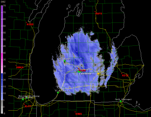
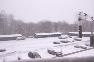
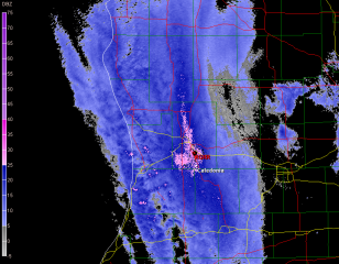
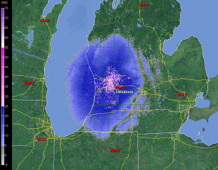
But that has changed with the arrival of this latest winter storm, which I am live-streaming on iMap even as I write. Here’s what it looks like on the radar as of around 9:20 a.m. (Click on the image to enlarge it.) A little farther down the page is a corresponding view from my balcony here in Caledonia, Michigan. Let’s put it this way: it’s not very pleasant outside.

The Grand Rapids weather office has this to say:

...WINTER WEATHER ADVISORY REMAINS IN EFFECT UNTIL 7 PM EST THIS
EVENING...

HAZARDOUS WEATHER...

 * SNOW WILL CONTINUE TO FALL ACROSS THE AREA INTO THIS MORNING
   BEFORE TAPERING OFF. SOME LOCAL POCKETS OF HEAVIER SNOW WILL BE
   POSSIBLE AT TIMES.

 * STORM TOTAL SNOW ACCUMULATIONS OF 3 TO 6 INCHES ARE EXPECTED
   THROUGH 7 PM FRIDAY EVENING...WITH LOCALLY HIGHER AMOUNTS
   POSSIBLE.

 * SOME WIND GUSTS OF UP TO 30 MPH WILL CAUSE SOME BLOWING AND
   DRIFTING SNOW LATER TODAY.

The updated aviation forecast includes this addendum:

AREAS IN THE WARNING WILL SEE 5 TO 8 INCHES WITH SOME AMOUNTS UP TO 10
INCHES POSSIBLE.

Latest station ob at GRR shows a temperature of 27 degrees. That’s not at all horrible for this time of year in Michigan. What we’re getting is actually standard fare. But that’s not to make

light of it. Conditions certainly aren’t balmy, and a 20-knot northwest wind doesn’t help. This is a great day to be inside. It’s times like now when the benefits of working at home become strikingly apparent. No scraping ice off the windshield of my car. No driving down icy roads. Just a manuscript to edit while catching glimpses of the birds swarming the feeder against a backdrop of windblown snow.

Life’s good things aren’t necessarily pricey. I’m content with a cuppa joe, a warm apartment, my work in front of me, and a pretty landscape outside the window with the snow piling up. From the looks of it, we’ve got around four inches right now. Bring on the rest of it. I’m not going anywhere.

Just in Time for the New Year: Real Winter Is Here at Last

With the arrival of the new year, Winter 2012 appears to finally be kicking into gear here in West Michigan. I’m ready for it. We got off light in December, with little in the way of snowfall and much in the way of unseasonably warm temperatures. On New Year’s Eve, temps scraped above 40 degrees. In that respect, this New Year has been very similar to the last one, though not quite as warm.

The mercury started dropping yesterday afternoon as the wrap-around from a departing low ushered in colder air, and with it, the first significant snowfall of the season. Here’s what the L2 radar looked like at about 1:00 p.m. yesterday as the snow was getting started. Possible blizzard conditions were in the GRR forecast discussion at that point, but the winds never intensified to that level. Station obs currently show northwest surface winds up to 20 knots through West Michigan, and just up the road at the airport the temperature is 25 degrees. That sounds like winter to me.

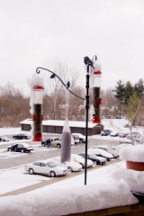
And the snow that is piled on top of my balustrade and covering the cars out in the parking lot looks like winter. Here’s a view of the bird feeding station out on my balcony to give you an idea of how much snow has stuck since yesterday. Looks to be about four inches. More may visit me yet here in Caledonia, but right now we appear to be situated between bands of the heavy lake effect stuff, with the most intense band streaming south-southeast from along the lakeshore by Muskegon and Grand Haven toward Kalamazoo and Centreville.

I see that a few storm chasers are out for a romp. Enjoy yourselves, lads. Me, I’m recovering from a sprained ankle and my car is in the shop, so I’m not going anywhere. Today is a day to ice my ankle, kick back with a big mug of Lapsang Souchong tea, watch the finches frolic at the feeder, work on an editing project, and let the icy winds blow.

Happy New Year, everyone!

September 3, 2011, Outflow Boundaries

Yesterday morning my friend Kurt Hulst called to say, “Grab your camera. There’s a great shelf cloud coming your way. It passed my location before I could get a picture.”

Okay, then. My apartment faces east, and all I could see was blue sky. Not even a hint that a storm might be approaching from the west, and usually one gets at least some kind of a clue. But I snatched up my camera and car keys regardless and headed outside.

Yes, there it was–a hazy arcus cloud moving my way from the west and northwest. I hopped in my car, with the intention of finding a better view for taking photographs than my parking lot afforded. But the cloud was moving faster than I realized, and by the time I reached 108th Street, it was almost on top of me. So, with the wind kicking up flurries of leaves in front of me, I headed east, thinking to put a little distance between the shelf cloud and me.

Several miles down the road, I turned north, parked by a buffalo farm, stepped out of my car to get a look, and realized immediately that my cause was lost. The cloud was right overhead. It had to have been moving at least 60 mph. So much for weather photos. Within seconds, I was looking at the backside of the arcus, and it wasn’t particularly photogenic.

For that matter, there wasn’t much to it. No ensuing rain, no lightning, no thunder, no storm at all, just blue skies. I can’t speak for other parts of the country, but here in Michigan it is an odd thing to observe an impressive-looking shelf cloud with absolutely nothing behind it! The cloud evidently had formed as the isolated effect of cold outflow from dissipated storms back in Wisconsin, in conjunction with a closer, severe-warned MCS to the north. Back at home, I could see the outflow boundary arching southwest all the way down into Indiana and moving rapidly east.

Yesterday seemed to be the day for such phenomenon to be clearly defined on the radar. Later in the afternoon, GR3 showed a similarly highly distinct outflow boundary down in northern Indiana. The source of this one was easy

to see: storms to its northwest and north. It looked pretty vigorous, and I wondered if it was putting on a show similar to what I had witnessed.

As an item of curiosity and an example of a highly defined outflow boundary–I suppose you could call it a runaway gust front–I captured a screen shot. Click on the image to enlarge it.

Tornadoes in North Central Nebraska

With family visiting from various long-distance places of the globe, I’m not posting much these days. However, last night provided an interesting spate of late-season tornadic activity in north-central Nebraska that I’d be remiss in not slapping up a couple images from GR2AE at the peak of the activity.

Look at that pinhole in the reflectivity knob! I was even better defined in the ensuing scan, after which the rotation became more diffuse and the storm began to weaken. Prior to this, a few dedicated and fortunate chasers videotaped a nice

stovepipe tornado near Wood Lake. All this in northwest flow with the storms moving in a south-southeasterly direction.

April 22, 2011, Saint Louis “Good Friday” Tornado

Saint Louis, Missouri, has been hit a number of times  by tornadoes over the years, most notably on May 27, 1896, when a violent tornado claimed 255 lives. Last Friday my friends Bill Oosterbaan, Kurt Hulst, Mike Kovalchik, and I witnessed the first EF4 tornado to strike the metro area in 44 years.

I use the word “witnessed” loosely as we really didn’t see much of anything. Bill observed wrapping rain curtains just to our west, Kurt and Mike saw a couple power flashes, and I captured a feature on video that may have been the funnel cloud, but mostly what we saw was a whole lot of blowing rain and brilliant, nonstop lightning. Judging from the lack of any other videos that show a clearly defined tornado, our experience was typical. If anyone was in a good position to see the condensation funnel, it was us, and perhaps we would have seen it had the storm struck an hour earlier. But I suspect the thing was too rain-wrapped for good viewing even in broad daylight.

The storm initiated southeast of Kansas City near the triple point of an advancing low. Poised at the northernmost end a broken line that backbuilt southwest  into Oklahoma, the incipient cell split and the right split grazed eastward along a warm front draped over the I-70 corridor.

We first intercepted the storm south of Columbia outside the town of Ashland. At that point it was getting its act together and was already tornado warned. The sirens sounded right next to us as we stood and filmed, but the storm had a ways to go before it finally went tornadic. Where we stood southeast of the updraft base, the air was dead calm–not even a breath of inflow, nothing but the year’s first mosquitoes to remind us that spring was well underway south of our home state of Michigan.

Keeping up with this storm would likely have been much easier had we not chosen to head back to I-70, where eastbound slowdowns hung us up and golfball hail on the north end of the supercell clobbered us. The storm organized beautifully for a while on the radar, but there wasn’t a thing we could do about it with traffic crawling along. Thanks to Bill’s great driving, we eventually did get clear, but by then the storm appeared to have turned to junk.

Just goes to show how deceptive appearances can be. Shortly after we had written the storm off, the radio announced the first reports of tornado damage in New Melle, and from then on, the reports continued. As fellow Michigan-based storm chaser L. B. LaForce put it, “I got a good look at the base just south of Innsbrook and it looked like crap. It tightened up shortly thereafter.”

Indeed it did, as strong and continuing radar couplets bore out. Dropping south on US 40 to get a better view of the storm, we parked by a cemetery and  finally got a good look at the action area to our southwest. Against the dirty orange backlight of the fading sunset, a conveyor of low clouds flowed from the north into an area of murky blackness bristling with lightning. Unquestionably this beast  meant business and intended to transact it along the worst possible path: right through the heart of  northern Saint Louis.

Along its 22-mile path, the tornado inflicted its most widely reported damage at the Lambert–Saint Louis International Airport. It’s a miracle that no one was killed or seriously injured at this location. That may very well include us. We had exited I-70 in order to get a look at the storm, or at least try to, and by the time we were back on the highway the radar showed that we had compromised our safety and needed to git, fast. It was at this point that Bill thought he saw the rain curtains swirling, and Kurt and Mike observed what looked like power flashes. Hard to say, given the intensity of the lightning. What’s certain is that we missed the tornado by the skin of our teeth, because the radio announced only minutes later that Lambert Field had been hit. The bear had been breathing down our necks. Funny thing is, I’ve driven through much worse conditions at night. But conditions can change in a heartbeat, and in this case they wouldn’t have changed for the better.

The seriousness of the damage inflicted by this tornado didn’t sink in until a while later when reports, photos, and YouTube videos began to filter in. EF4 damage occurred about a mile-and-a-half west of the airport. At Lambert, the damage was rated EF2 and resulted in closure of the airport. A photo of a passenger bus hoisted up onto the roof of an airport building demonstrated the power of the winds.

The Saint Louis NWS report on this event lists two tornadoes, the first a brief EF1 that did damage in New Melle, followed by the long-track, EF4 monster that chewed through Saint Louis proper, beginning along Creve Coeur Mill Road near Griers Lane and dissipating across the Mississippi River south of I-270 and west of Pontoon Beach, Illinois.

Why did the storm wait until it was just west of Saint Louis to begin spinning up tornadoes? The best explanation I’ve heard is one that was offered on Stormtrack. Evidently the warm front had moved north of I-70 on its western side, where the low initially lifted through Kansas City. But farther east, the front sagged southward through Saint Louis, backing the surface winds. The storm, moving eastward through the warm sector just south of the warm front toward an inevitable intersection, finally interacted with the front itself and began to ingest the enhanced helicities. Suddenly, boom! Tornadoes.

Farther east into Illinois, although it continued to be tornado warned, the storm gradually weakened and lined out, leaving Bill, Kurt, Mike, and me to enjoy a spectacular light show for much of the ride home. I finally clambered into bed around 5:00 a.m.

The stormy weather continues unabated down south. As I write, Bill is chasing down in Arkansas north of Little Rock. Judging by his position on Spotter Network, it looks like he may have bagged a tornado. Guess I’ll find out in a while. I wish I was there too, but this week is spoken for. I have a gig tomorrow afternoon, and then Mom goes in for knee surgery on Wednesday. So I won’t be chasing through the weekend. After that, we’ll see what the weather holds. This has become an active April, and now we’re coming up on May. I can’t wait to hit the road again!

April 14-16 Southeast Tornado Outbreak: Thoughts and Images

There are times when the sight of a high risk sickens rather than excites me, and Saturday was one of those days. It’s one thing when severe storms occur in the Great Plains where the population is sparse, but when a swarm of tornadoes roars across an area punctuated with cities and towns, all I can think is, “Oh no. All those people!” Such was the case with last week’s horrendous three-day tornado outbreak across the South and East.

The outbreak commenced Thursday in Oklahoma, Kansas, and Arkansas, with a preliminary figure of 27 tornadoes reported.* The action ramped up Friday in Louisiana, Kentucky, Missouri, Illinois, Mississippi, Alabama, and Georgia, with an initial tally of 120 tornadoes. Day three was the worst of all, with yet another 120 reported tornadoes slashing across the populous, densely forested Southeast and East from South Carolina to as far north as Pennsylvania. Hardest hit was North Carolina, where large and powerful tornadoes ripped through Raleigh and other communities. Twenty-two lives were lost, 11 of them when a three-quarter-mile-wide, EF3 monster carved a 19-mile path across Bertie County. Another six died in Virginia. And in its previous two days, the outbreak claimed seven lives in Arkansas, seven in Alabama, two in Oklahoma, and one in Mississippi.
In all, Saturday’s tornadoes were North Carolina’s most lethal since 1984, when 42 died. And regionally, Friday and Saturday were the worst tornado outbreak in the Southeast since the Super Tuesday Outbreak of February 5–6, 2008, when 87 tornadoes killed 57 people in four Dixie Alley states.

But my point in writing this article isn’t to provide yet another news story on the disaster. Rather, it’s to share my feelings as I watched it unfold. With some truly amazing video coming in from chasers in Oklahoma, the first day was fascinating. Day two, watching tornadic supercells crawl across Mississippi and Alabama on the radar was unnerving; I hoped nothing bad would happen down there in the South, but I knew better. On day three, when I saw the high risk go up in North Carolina, my heart sank.

When it comes to armchair chasing, I’m moderate in my habits. If I can’t actually be out chasing, I often opt for a more constructive use of my time than watching the radar and gnawing my knuckles. This time, though, I couldn’t help watching. At first the line of storms looked mean but not terribly alarming. As the storms headed east, though, they began to organize and strengthen, and circulations began to show on radar. Strong circulations, a whole line of them, stretching from northern South Carolina up into Maryland and Virginia. And the tornado reports began filtering in. These storms didn’t merely appear to be impacting towns–they were.

I watched one monster chew through Raleigh, thinking, “No way!” Then came the videos on YouTube, one of them by chasers at unnervinglyclose range, and I knew. No one was dodging the bullet this time. Neighborhoods were being pulverized and people were dying.

With fiscal conservatives recently wanting to slash the budget of the National Weather Service, all one has to do is witness a scenario like last weekend’s in order to realize the supreme lunacy of such a move. Tornado season is just getting started. More is on the way. Bad as last week was, we could yet see worse. How smart is it to pull the rug out from under our national weather warning system at precisely the time of year when its optimal service is most needed?

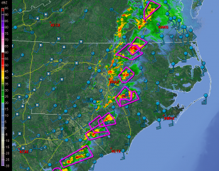
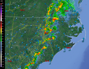
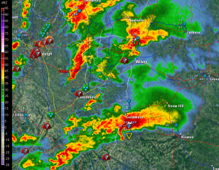
But I digress. Here are a few GR2AE radar grabs of the North Carolina supercells. Storm motions were to the northeast. The rest tells its own story if you know what you’re looking at.

First, here’s are a couple macroscopic views.

Next, I’ve zoomed in on the Raleigh radar to  cross-check reflectivity and storm-relative velocity on a couple supercells.

The final image was taken after the storms had moved out to sea. It shows a couple of northern line-end vortices that I found interesting and thought you might too.

____________________
* All numbers reflect preliminary reports at the time of this post’s publication. Final statistics will likely be different.

The Groundhog Day Blizzard of 2011

blizzard3-2011The cloud tops are up to 20,000 feet here in Caledonia, and about two minutes ago the first impressively bright flash of lightning lit the blizzard swirling around my apartment. Thundersnow! Rare, but  not unexpected tonight, and now that it has arrived, I’m continuing to see sporadic flickers of lightning. That initial one was a doozy, though, and all I can think is, Cool! How often does one get to hear thunder rumble through the teeth of a February blizzard?

Man, is it blowing out there!

All eyes have been on this winter storm for the past several days, watching it move from forecast models into reality. Nowcloud-tops-2011here it is, and it is a humdinger. Anywhere from a minimum of 12 up to 16 inches of snow is predicted to dump on our area, and south of us it only gets worse. Pink is the color that indicates heavy snowfall on my radar color table, and I don’t recall ever seeing such a large expanse of it covering my screen before. Between now and sometime tomorrow morning is when the heaviest snowfall is supposed to occur, and looking outside my window at the maelstrom swirling dimly out of the midnight sky, I see nothing to contradict that prognosis.

blizzard4-2011Ah! Another flash of lightning and another rumble of thunder! This is nice. Imagine that–me, an avowed snow grinch, enjoying a blizzard! But I have to say, this storm appears to be living up to all expectations. I honestly don’t recall that I’ve ever experienced thundersnow before, so I’m really pleased to be getting such a novel form of entertainment.

The three fairly recent radar grabs and the water vapor image on this page will give you an idea of what a truly wild evening this is. Click on the images to enlarge them. The first and third are basic winter reflectively images, with the latter offering a more zoomed-in look at southern Michigan. Look at all that pink! Interrogating a few of the deeper hues has given me reads of nearly 40 Dbz, and that’s nothing compared to elsewhere, and perhaps to what yet lies in store for us.

blizzard-2011-wvAs for the second screen, that shows cloud tops. The teal colored blobs indicate tops of 20,000 feet or greater, where thundersnow is likeliest to occur. And the fourth image depicting water vapor gives a macro view of what the entire system looks like as an immense entity sweeping eastward, with the dry slot punching upward into Illinois.

This may be one for the history books. I’m glad I stocked up on groceries, because I doubt I’ll be venturing out tomorrow. I doubt anyone will be. I’m certain that all the schools will be closed, and quite possibly many businesses as well. It will be a good day to hunker down and feel grateful for being indoors.

Zang! Another bright flash. I just got a phone call from my friend Brad Dawson, who lives down near Gun Lake. He tells me that a big towerblizzard6-2011500 feet from his house is getting continually struck. That has to be an experience, and from the looks of things, it’s apt to be one that continues through the night. Lacking any similar tall objects here, the lightning isn’t as constant, but it continues to flicker, and the storm itself is intensifying. What the heck–here’s one last image: a current radar scan. I just got a reading of 43.5 Dbz in one of the darker blobs of pink!

This is one howler of a winter storm system. But I’m done watching it for now. It’ll still be here in the morning. Time for me to hit the sack and enjoy the light show for a while before I fade out. Good night!

New Years Eve Severe Weather

new-years-eveHere’s something you don’t see very often on the morning of December 31. (Click on thumbnail to enlarge it.) It’s 10 a.m. and for the last half-hour I’ve been watching lightning flicker outside my window and listening to thunder rumble.

But that’s nothing compared to what’s going on farther south. Already three fatalities have been reported in Arkansas, and tornado warned storms are scraping across the region. As I write, there are two strong SRV couplets in Missouri southwest of Waynesville and west of Houston–potent little supercells fueled by dewpoints in the upper 50s. It’s new-years-eve-mo-srvcertainly not what you’d expect this time of year, but this event has been shaping up for several days.

I’ve got a gig this evening–it’s New Years, after all–so my extent of involvement in this weather scenario will be to watch it unfold to the south of me on radar and enjoy its occasional outbursts of lightning and thunder here in my own Michigan backyard. Later today Louisiana and Mississippi could get hammered, but right now the action is farther north, where buckets of shear are organizing the storms and driving them along at 50 new-years-eve-mo-refmiles an hour. If that little bugger south of Waynesville holds together, Rolla is going to get whacked within the next half hour.

Enough writing. I’m going to upload some radar images for this post and then watch this event unfold.

First Day of Meteorological Winter

Some of you will greet the news with glee, others with a groan, but either way, today is the first day of meteorological winter. Right, we’ve still got another three weeks before the winter solstice, when the year’s shortest period between sunrise and sunset marks the arrival of astronomical winter in the northern hemisphere. But it sure looks like winter right now to me, and that’s what matters to meteorologists. For them, winter begins December 1, just as each of the other three seasons commences on the first day of its three-month block. Why? Because that arrangement corresponds better with how we experience seasonal weather in real life. Here in Michigan, we often get a pretty good hammering of snow in November, and by winter solstice on December 21 (or sometimes 22), we’re already usually pretty well socked in. It seems almost laughable when someone announces on solstice that it’s the first day of winter. Really? Could’a fooled us. We thought it began a month ago.

I woke up this morning to be greeted, very appropriately, by the year’s first snow accumulation. Yesterday temperatures opened in the low fifties, but they began dropping and the afternoon grew downright chilly. Today snow is falling, and out in the parking lot a woman is brushing the white stuff off of her car. It’s almost like winter has been consulting its watch, waiting in the wings and then entering the stage exactly on cue with a bucketload of lake effect. The snow will be with us for a few days, now, and the radar will continue to look a lot like the image on this page. Click on it to enlarge it, and get used to it, because you’ll be seeing a lot of similar pictures from now until meteorological spring arrives on March 1, 2011.