The Day Before Groundhog Day: Yet Another Winter Storm–and More on the Way

Today is February 1, and let’s just say it: This winter is getting reeeaaaally old. Incursion after incursion of Arctic air. Snow, snow, snow. Cold, cold, cold–and I do mean cold. After Monday and Tuesday’s bitter, subzero bite, these mid-twenties temperatures that have moved in feel practically tropical.

Winter_Storm_02012014
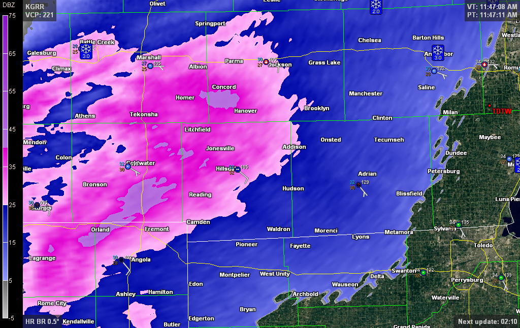
We’re presently under a winter weather advisory, with 3 to 5 inches of snow forecast through 10:00 p.m. around here and an inch more to the south and southeast along the I-94 corridor. And it’s wet snow–not as bad as initially expected, according to the latest KGRR forecast discussion, but still watery enough–and therefore heavy enough–to put added stress on flat roofs. Here’s a radar image from a few scans back. Look at all that gray! I hardly ever see returns that hit 40 dBZ with a winter storm, but a bit of interrogation revealed 49.5 dBZ over US-131 with this particular scan. And it appears to be all snow too, not a wintry mix. So yeah, I’d call that wet snow.

Snow Depth Feb 1 2014
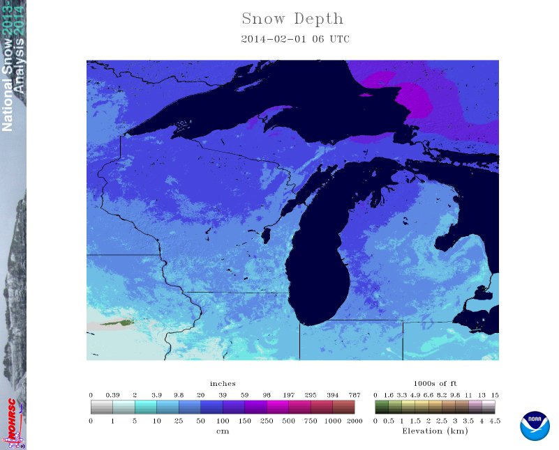
The thing is, this stuff just keeps coming. We all know that by now. I haven’t seen a winter this snowy since 2009, maybe even before that, since . . . since . . . well, I don’t know when. As you can see from today’s snow depth map, there’s a strip running through my area along the western side of Michigan where the snow depth reportedly exceeds 20 inches. We’re not talking about how much snow has actually fallen this winter, just how much of it is presently sitting on the ground. Twenty inches. I can testify that around here, it’s not hard to find places where it’s nearly up to my knees. Heck, just along the sidewalk outside my apartment, the snowblower has neatly carved a minor canyon along the edge of the featureless white expanse which, if my memory is accurate, used to be what is called a “lawn.”

Feb 1 GFS 132-hr fcst
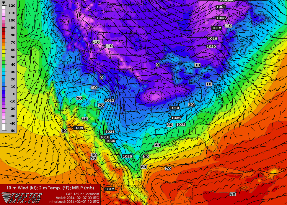
How about one more image? Look and groan, because all this glorious wintry nastiness doesn’t look to be retreating anytime soon. You’re looking at the 132-hour forecast for the surface temperature. Doesn’t that look inviting, so full of hope and promise? Tomorrow is Groundhog Day, and I’m telling you right now, that little cretin had better not show his face anywhere in my vicinity or I will send him into permanent hibernation.

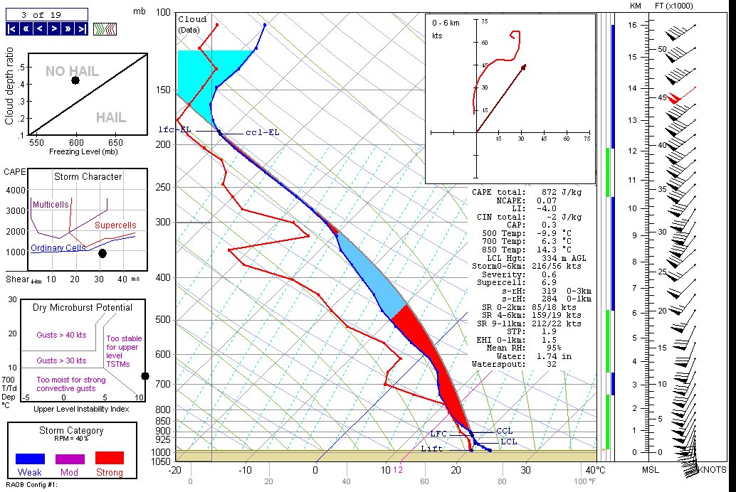
If there’s one good thing about this winter from a personal perspective, it’s that it has inspired me to learn about winter forecasting. There’s certainly every opportunity to do so, and plenty of incentive. So I’ve learned a few new terms. Try this one on for size: heterogeneous nucleation. I like that one. Or how about this: DGZ, which stands for dendritic growth zone, the temperature range between -12 and -18 degrees Celsius wherein a saturated layer produces snowflakes. Got that? I’m starting to, along with a deeper appreciation for my RAOB software program.

But I’d still be glad to see all this snow and cold go bye-bye, and I’ll bet I’m not the only one. Well, well . . . buck up, ladies and gentlemen: meteorological spring is on the way. I just have a hunch it won’t be here March 1. It’s arrival time may be delayed by snow.

What about you? Are you a winter lover or a winter Grinch–or has this winter turned you from one into the other? How do you think this crazy-cold, uber-snowy weather might affect the spring storm season? Drop a comment and share your thoughts.

Rob Dale on Free Learning Resources for the Prerequisites of Meteorology

I owe the following content to meteorologist and Ingham County, Michigan, emergency manager Rob Dale. With his permission, I’m duplicating it here from Rob’s Facebook post, as I think some of my weatherhead readers may find it relevant and useful. That has been my experience; thanks to Rob, I’ve actually begun to look into tackling high school algebra–a subject I did horribly at back in my teen years–with an eye on laying the groundwork for calculus, and thence, meteorology. One is never too old to learn, right?

Perhaps the free resources Rob has listed below will inspire you too to expand your learning horizons. In any case, the legwork Rob has done is too valuable to be buried beneath the Facebook landslide.

Here’s Rob.

————————–

Let’s say you’re interested in REALLY learning about meteorology? You have NO idea how many resources are available today compared to just 5-10 years ago! You can take most of the core courses that currently cost thousands of dollars at a university for free at your own pace… For example, a met degree requires Calculus, Physics, and Chemisty off the top. Once you have that background, you can start reading intermediate (and maybe advanced) textbooks and actually learn how to forecast. You still won’t be a full fledged met, but I guarantee you will make better forecasts than now and you will feel better knowing your knowledge is the reason why. You can find them elsewhere, but many of these from MIT have full video lectures which makes the process easier.

https://ocw.mit.edu/courses/mathematics/ 18.01, 18.02, 18.03
https://ocw.mit.edu/courses/physics/ 8.01, 8.02
https://ocw.mit.edu/courses/chemistry/ 5.04, 5.60

Now you’ve got the basics! You can get meteorology books, will understand what you’re reading, and actually start to make sense of the “why” behind the process.

https://www.amazon.com/Introduction-Dynamic-Meteorology-Fifth-Edition/dp/0123848660/ref=pd_bxgy_b_text_z
https://www.amazon.com/Mesoscale-Meteorology-Midlatitudes-Advancing-Weather/dp/0470742135
https://secure.ametsoc.org/amsbookstore/viewProductInfo.cfm?productID=81
https://www.amazon.com/Synoptic-Dynamic-Meteorology-Midlatitudes-Principles-Kinematics/dp/0195062671
https://www.amazon.com/Synoptic-Dynamic-Meteorology-Midlatitudes-Observations-Weather/dp/019506268X/ref=pd_sim_b_1
https://secure.ametsoc.org/amsbookstore/viewProductInfo.cfm?productID=5
https://secure.ametsoc.org/amsbookstore/viewProductInfo.cfm?productID=6

Some of those books can be expensive, but buy one at a time and you’ll be able to sell them for about 80% of what you paid (if not more.)

Does this sound hard? Yup. Necessary if you want to really know meteorology? Yup. Impossible? Nope. Just think how much time you are wasting drawing lines on Microsoft Paint and how those hours could actually help you learn! If you really wanted to be a guitar player would you be better off spending time on Guitar Hero or learning chords on a real guitar? One of them is fun in the short term but offers no advantage towards your goal. Same story here.

So there you go. If this is REALLY your passion, make it something valuable. If you end up going to college, think of how much easier those classes will be since you’ve already invested ahead of time! If you don’t go to school, imagine how much more interactive your conversations can be with meteorologists and how much of a service your posts will be to followers.

————————–

Now, if you, like me, totally sucked at any form of math back in your high school daze (daze being a fully appropriate word for a child of the 1970s), Rob has also provided a link to KhanAcademy, which provides a blizzard of tutorials on the prerequisites for college-level courses. And yes, they too are free, free, free.

Considering the education you can get online today without paying a dime, the only thing that can cost a person is to remain ignorant. Learn at your own pace for your own enrichment and satisfaction. What’s to stop you?

Hey, Rob–thanks! You rock, Pilgrim.


Winter Solstice 2013: Tornadoes (or Not) in Dixie Alley and Ice Storms North and West

It has finally arrived: Winter. Astronomical winter, that is. Meteorological winter has already been with us for three weeks, beginning December 1, and in my book, that is the more climatologically accurate date. Particularly this year. For the first time since 2009, we in Michigan have been experiencing a good, old-fashioned Great Lakes winter. Here in Caledonia, the snowfall has exceeded a foot, and Lisa, who arrived here from Missouri five years ago hating winter and now loves it, dotes on it, rejoices in it, has been having a high good time during her two daily walks, equipped with brand-new winter hiking boots and a warm, warm, waaarm and dry, dry, dry waterproof down coat.

I am not so enthusiastic about all this white stuff as Lis is. My interaction with winter consists largely of sitting indoors at my work station, gazing out through the sliding door, watching the finches argue at the feeders and the woodpeckers whack away at the suet, and watching snowflakes pirouette gracefully out of the sky, and thinking, “Can we get this over with?”

Yes we can, in a few more months. Because today at last we tip the scale, and from here on, daylight will be on the upswing.

Two weeks ago, on December 8, the sun set in my town at 5:08 p.m. EST, just as it had been doing for the preceding four days, hovering within the eight-minutes-past-the-hour range but setting just a few seconds earlier each day. The 8th was the earliest sunset date of the year. From then on, sunset time would arrive incrementally later. For the next five days, through December 13, it would remain at 5:08, but instead of losing seconds, now it would begin to add them back until, on December 9, the sun would set at 5:09.

The converse does not, however, hold true for the day’s first light. The sun will continue to rise later and later until January 3 of the new year. By then, the sun will have been rising at 8:14 a.m. for five days until finally, on that date, the sunrise will, like the sunset, hit its own tipping point. From thenceforth, losing a few seconds each day, it will begin its slow march toward an earlier and earlier hour. On January 8, it will rise at 8:13 a.m.; on January 12, at 8:12; on the 14th, at 8:11; and so it will go, until on the 31st, it will rise at 7:59. By then, the sun will be rising approximately a minute earlier each day, and we will have gained fifteen minutes of sunrise time.

Why, then,  is today, winter solstice, so special? Because today marks our shortest period of overall daylight, the narrowest space between sunrise and sunset. From tomorrow on, even though the sun will continue to rise later and later for a while, the sunset time will begin to outpace it and the gap between sunrise and sunset will broaden–slowly at first, then with increasing swiftness. By the end of December, we Grand Rapidians will have gained 41 seconds of daylight for a total of 9 hours, 14 minutes, and 16 seconds on December 31. By March 18, we’ll be adding daylight at 2 minutes and 15 second per day, at which point we’ll have maxed out and the gains, while still continuing up to the summer solstice, will become gradually less.

You now know more about the winter solstice than you probably ever cared to. What makes this particular solstice even more interesting is the weather that’s shaping up for it, which shows promise of making it a headliner with tornadoes in the deep South and ice storms to the north and west.

Day 1 Winter Solstice 1630 Mod Risk 2013Here is the 1630Z convective outlook for today, depicting a moderate risk stretching from western Kentucky and Tennessee southwestward into Louisiana, with a 15 percent hatched area for tornadoes.

Given the brevity of daylight, I find this situation interesting but not particularly appealing.  A look at forecast soundings suggests a crapload of rain, low CAPE, and high helicity, all driven by massive shear and Jackson MS 19Z RAP_Skew-Trocketing along through formidable terrain. A lot of chasers are out there, and I’m sure that if I lived in that area, I’d be among them, but looking at the Shreveport radar, I don’t feel like I’m missing out on something. I got my fill of chasing fast-moving, rain-wrapped storms last November in optimal territory, and considering how that chase turned out, I think I’ll be a lot more selective about such scenarios in the future. That said, I wish those who are out there good success.

And safety. Drive carefully, mates and matesses. No storm is worth jeopardizing your safety over.

As for me, I’m sitting well on the other side of the cold front, and freezing rain is in the forecast, though my local WFO has backed off on it in their forecast discussion. Lots of areas in the Midwest are getting hit with icy conditions, making for hazardous driving, power outages, downed tree limbs, and the like.

The day grows later, and so far, glancing at the radar down south, I just don’t see anything very exciting–just a messy-looking MCS with one cell south of Memphis showing a hint of rotation. Only wind reports so far, and I suspect that’s how this thing will continue to play out. Tough for anyone who drove down there hoping for more; good for denizens of the region.

And so enters the winter of 2013–14. Time to wrap up this post and get on with the rest of this afternoon.

September Gilds the Fenlands

Upton Road Fen in northern Barry County, Michigan.

Upton Road Fen in northern Barry County, Michigan.

Three miles south of Middleville, Michigan, lies Upton Road Fen. That is the name I have given the place for convenience to provide some sense of location. In reality, the fen is nameless. Rarely do wetlands in Michigan have an actual place name, and in the case of this wetland, that is just as well, because the name “Upton Road” hardly does justice to either the magnificent sweep and diversity of the fen or the loveliness of the sandy forest trail that winds through archways of hardwood past the fen’s northern border.

A feather tamarack stands sentinel at the fen's northern border.

A feather tamarack stands sentinel at the fen’s northern border.

Prairie fens are a rare and unusual kind of alkaline wetland, rich in plant life, and Barry County is a bastion for these beautiful and fascinating ecosystems. Upton Road Fen may well be the largest of its kind in this part of the state. If not, it is certainly one of the larger ones, stretching three-quarters of a mile from corner to corner and encompassing a wide palette of fen habitats, from drier cinquefoil fields, to sedge meadows, to a wet, reedy seep, to a floating mat on the lowest, southeast end.  Pitcher plants grow here, and wild orchids, and blazing star, and deep blue fringed and bottle gentians. Tamaracks rub shoulders with red cedars, and here at the end of September, poison sumac shrubs dot the periphery of the fen, glowing incandescently like fiery rubies strung across a vast necklace where the wetland meets the woods.

Unidentified seed pod. Any guesses?

Unidentified seed pod. Any guesses?

I have come here on this bright, late afternoon in search of gentians, and I am not disappointed. They are here, fully open, batting their fetching blue lashes at the slanting September sun. Little coquettes! Gentle, sweet wildflowers, flirty yet shy, like teenage girls just discovering their charms. I have intended to get photographs, but my camera’s battery is lower than I realized, and it dies on me after just a few landscape shots plus some odds-and-ends closeups. The latter include this old seed pod with one tufted seed still clinging gallantly to it. I don’t know what the plant is–it’s actually a shrub of some kind, and far be it from me to venture a guess as to its identity. I’m just not much of a shrub man.

I walk cautiously, keeping an eye out for massasaugas. In the many times I have visited this fen, I have never seen one, but I am told they are here and actually plentiful. I would love to see one, but not today–I left my heavy boots at home, and I wouldn’t care to have my first encounter with Michigan’s only rattlesnake result from my stepping on one with these old, threadbare athletic shoes I’m wearing.

Looking south across the long reaches of the fen.

Looking south across the long reaches of the fen.

Fortunately, my snakeless record remains pristine as I head back to the car. It has been an all-too-short visit on this radiant afternoon, but I have things to do and it is time to go. I am grateful, though, for these few minutes here, beyond the grasp of the frenzied world, where time slows down and invites me to do likewise long enough to see the smile of my Father. He is a loving Creator who has much reason to look upon these works of his hands–these golden fields, this sun-gilded fen stretching luminously beneath the September sky–and call all of it good. Yes, very good indeed.

May 28, 2013, Tornadic Supercell by Grand Ledge, Michigan

Tornado season is now long past, and the sting of missing great storms either through bad targeting or having to head home one and two days before two major events has eased. Maybe next year will be better. Besides, the show’s not over till the snows fly.

Meanwhile, I’m looking back to my most interesting chase of the year, documented by the video at the bottom of this post. Ironically, I logged around 6,000 miles to and from Oklahoma and Kansas with little to show for it, while my humble backyard of Michigan gave me an enjoyable and productive bit of action.

On May 28, a warm front lifted up through lower Michigan, ushering in decent moisture and instability along with a good boundary for them to work their mojo with. The thing that seemed to be missing was adequate shear for storm organization–but I ignored conditions farther east of me. I just didn’t take the setup seriously enough, and when Kyle Underwood, the WOOD TV8 meteorologist, inquired which of the TV8 chasers planned to head out, I said that I didn’t see much potential. If something came my way, I would grab it, but otherwise, I didn’t want to waste gas. That was understandable: money was tight, and I planned to chase in Kansas the next day. Still, geeze, what an idiot (me, not Kyle).

Let us pause momentarily while I give myself a retroactive dope slap. I have come to a conclusion: in Michigan, when a warm front shows up with good CAPE present and any kind of bulk shear to speak of, even anemic bulk shear, chase the front. Never mind what the models have to say about storm-relative helicity; helicity will take care of itself if a storm manages to organize in the vicinity of the frontal boundary. Just get out there and chase the stupid front. Particularly farther to the east. Storms in Michigan often have a way of intensifying and organizing near and east of I-69 and, north of Lansing, US-127.

That was the case on this day. My first clue was when I glanced at the radar later and noticed that Kurt Hulst was on a storm off to the southeast. Kurt knows what he’s doing, and the storm looked decent–in fact, it was tornado-warned. Okay, I thought, I missed that one. Probably it’ll be the only one. So I sat tight and watched the radar as other storms formed. They looked like a convective mess to my west, but they clearly were moving into a better environment as they progressed east. Finally, I’d had enough. I grabbed my laptop and cameras and headed out.

I locked onto the most intense-looking cell in my vicinity and tracked with it toward Portland. But another was following on its heels, and given the way that the storms were behaving, I thought I’d be better off dropping the one I was on and letting the new one come to me. Presumably, it would get its crap together on the way, and that is what happened.

As it approached Grand Ledge just west of Lansing, this storm developed a most amazing streamer of scud sucking into its updraft base from the east. It appeared to originate near ground level–hard to tell with trees constantly interrupting the view–and rocketed toward the storm, leaving no doubt that this storm had impressive inflow.

Driving into Grand Ledge, I found myself under the area of rotation, with crazy, low cloud motions. Turning around, I headed back north and parked by the airport, then watched and filmed as the storm headed east into Lansing. It looked very close to spinning up a tornado; in the video, you can see it trying hard, and eventually it succeeded.

But I had to drop the chase. My friend Steve Barclift and I planned to chase the next day in Kansas, and I had to meet him so we could hit the road for the long drive west. As it turned out, the storm I was on provided a better show than anything we saw along the dryline. My buddy Rob Forry managed to catch this storm at its tornadic phase and got some nice video.

My original hi-def shows the motion of the inflow streamer nicely as I enter Grand Ledge. Regrettable, this YouTube clip doesn’t render the details as well, but you’ll at least get a feel for the motion. The storm was an interesting one and fun to chase. It would be nice to get another one like it. It’s only August, so the door is far from closed.

Remember When . . . ?

Remember when tornado photos were all black-and-white, and you only saw them in the newspapers?

Remember how rare it was  to see them?

Remember newspapers?

Remember watching The Wizard of Oz every time it played on TV, and never missing a showing, just so you could watch the tornado scene? (“It’s a twister! It’s a twister!”)

Remember how fascinated and delighted you were when they showed those grainy old movies of tornadoes in school, or sometimes on TV, and how you wished they’d replay them and then replay them again so you could watch them over and over and over?

Remember when you first saw that incredible photo of twin funnels south of Elkhart, Indiana, taken by photographer Paul Huffman during the 1965 Palm Sunday Outbreak? And that dramatic image of the Xenia, Ohio, tornado shot at just a quarter-mile away from Greene Memorial Hospital during the 1974 Super Outbreak?

Remember your first successful chase? (As if you could ever forget.)

I remember mine. It was in August 1996 across central Michigan, roughly along the M-21 corridor. North of Saint Johns, Michigan, I watched as a beautiful tube dropped from a classic supercell that was as sweetly structured as anything I’ve seen on the Plains. Both the tornado and its parent storm were gorgeous–and I was elated.

Remember when there were no laptops, no Android phones, no mobile data, no GR3–just your car, your weather radio, maybe a tiny portable TV, and a ton of hopefulness and excitement as you drove happily down the highway toward a sky full of rising towers?

Remember when seeing a tornado was rare and busting was something you simply expected and took in stride as part of paying your dues?

Remember before the movie Twister came out?

Remember before the Stormchasers series?

Remember when storm chasing wasn’t “extreme”?

Remember when storm chasing barely was at all?

Remember when Storm Track was a print newsletter published by pioneer chaser David Hoadley? I regret that I never subscribed, because I could have learned much from it.

Remember when the online version was a resource everyone welcomed and loved, not a point of contention among some chasers? I’m so glad the worst of that scuffle is a few years behind us now.

Remember when there was no live stream to fuss with, no competing with a league of other chasers all getting similar footage of the same storm, and no rush to process your video and get it to the networks first? (Not that I would know about that last point personally. I’ve never gotten the hang of it and don’t particularly care.)

Remember when there was nothing to prove, no reputation to make or uphold, and no stripes to earn?

Remember when it was just about the storms, period?

Don’t you wish it still could be?

Why can’t it?

Remember how excited you were when you first got hooked up with a laptop, GR3, and mobile data?

Remember how, before then, you used to stop at airports and small-town libraries just to get a glimpse of the radar?

Remember when there was no TwisterData, no HRRR, no SPC mesoanalysis graphics, no easy way to obtain forecast soundings, no abundance of forecasting resources available at just the click of a mouse button?

Remember when you weren’t even aware that there were forecasting resources available to you?

Remember your first exposure to the SPC forecast discussions, reading through all that arcane gobbledegook and thinking, “These people speak Martian”?

And then thinking, “Maybe if I just head for the center of where it says ‘Moderate Risk’ . . .”?

Remember discovering COD and looking over their forecast maps and not having a clue what they meant or how to use them? You pulled up the 500 mb heights/wind map and admired the pretty colors and thought, “This looks like it could mean something.”

Remember not knowing the difference between GFS and ETA and RUC?

Remember ETA and RUC?

Remember knowing absolutely nothing about forecasting, and how you struggled to learn, and how thrilled you felt when you finally pieced things together and successfully picked a target, or at least had your forecast verify?

Remember all that?

Never forget.

Many of you are too young to have experienced some of the things I’ve mentioned. You missed out on something good. It doesn’t all sound good, I’ll grant you–no in-car radar, no access to a bazillion free online weather resources–but it had its virtues. Not that I’d care to go back to caveman days, but I’d love to reclaim their spirit.

The beat goes on, and those of you who boarded the bus farther down the road are building your own list of remember-whens. But we who are in our mid-forties and older can recall simpler times. They were far less technically advanced, but they were also infinitely less frantic and driven overall. I guess you have to reach at least fifty years of age before you get to say stuff like that. It’s the province and privilege of duffers. I qualify, and I’m okay with that.

I wish I could claim something akin to the number and quality of tornadic encounters, and the knowledge gained thereby, and the photos to show and the stories to tell, possessed by some of the luminaries who are my age or not all that terribly much older. Those guys have got a lot to remember! But what’s mine is mine, and it’s enough to reminisce upon. If you got your start when storm chasing was of a different character than it is today, you know that you were privileged to come up in a special time, a time that can never be reclaimed. And memories of those days are well worth treasuring and reflecting on and feeling grateful for the experiences that created them.


Subscribe by Email: Now Working

If you’ve tried unsuccessfully to subscribe to my blog updates via email, the problem is now fixed. It seemed odd to me that there had been no new email subscriptions since February–not that I normally get truckloads of them, but there are always a few each month, and the number keeps growing. So I decided to try subscribing myself and discovered that a snag in the process had indeed arisen.

Snag removed. If you were unable to sign up before, please try again. And if you still have trouble, please drop me a note and let me know.

Thanks,

Bob

NOTICE: STORMHORN THEME IS BEING UPGRADED

This site’s long-threatened change of theme is now underway. It is a custom theme designed by my lady Lisa, so it’s not as easy as just pulling the trigger and having everything fall into place. However, much of the upgrade is now completed, to the point where I’ve edited this post to reflect recent changes.

One major cosmetic change that is still on the way is the addition of an image slider underneath the header. It will be a nice touch once it’s installed, but it has presented problems, and there’s no telling how long it will take to get them resolved. It’s not a front-burner issue, but look for the slider to appear sometime within the next few months.

Other than that, the changes will filter in one by one, and some you may not even notice since they’re internal.

Patience, patience! We’ll git ‘er done, and I think you’ll like the new Stormhorn.com.

–Bob

Gulf of Mexico Sea Surface Temperatures and the 2013 Storm Season

Every year, the same question inevitably comes up: What is the upcoming tornado season going to be like?

The only truly definitive answer is no definitive answer. No one knows for sure till spring arrives, and the best any of us can go by are guesses, some better informed than others. I’m prepared to offer a few thoughts on the matter, but that’s all they are: thoughts, sheer speculation, items for consideration, not convictions or predictions; and they are those of a layman, not a professional meteorologist or a climatology expert.

With that caveat clearly stated,  I have some hopes that this year will offer a few more “big” chase opportunities than 2012. True, the horrible drought that put the kibosh on setups last year after April 14 hasn’t gone away, nor does it show any sign of letup. And without any evaporative boost from moist earth or vegetation, dewpoints are apt to mix out in the Great Plains. That’s no news to anyone.

ENSO 2013 SST Forecast MapsHowever, I have noticed that sea surface temperatures in the Gulf of Mexico are above normal, and the CPC’s (Climate Prediction Center) ENSO maps forecast them to remain so. Below are the most recent maps, current as of January 28,  covering the period from February through June, 2013. Click on the image to enlarge it. At the top right, you’ll see the Gulf of Mexico shaded in orange, indicating an average temperature deviation of 0.5 to 1.0 degree Celsius above normal closer to shore, and normal farther out.

These are coarse approximations, of course. But you can drill down a little further by checking out current buoy observations against average station temperatures, courtesy of the NODC (National Oceanographic Data Center). Below is their table showing current station obs for February 3 to the far left; and, extending to the right of the obs from some of the stations, average normal monthly temperatures.* A quick glance will tell you that SSTs were well above average for this date, and in light of the ENSO maps, it seems reasonable to think that they will remain so. In fact, today’s and yesterday’s readings seem to be about a month ahead of the game, though granted, those are just two days, and there are bound to be plenty of  fluctuations through the rest of the month.

NODC Current and Avg SSTs

What I feel safe in saying is that the overall higher SSTs in the Gulf of Mexico suggest a better moisture fetch than last year’s generally anemic return flow. Maybe the Midwest will benefit most from it, and I for one won’t weep if there are some decent setups closer to home. I can’t think of a better place to chase storms than the flatlands of Illinois.

However, it seems to me that Tornado Alley also stands a better chance of action as well, provided the polar jet cooperates this year by showing up farther south, where richer incursions of moisture can get at the energy. Neutral conditions that favor neither El Nino nor La Nina this spring strike me as more promising than last year’s La Nina.

I weigh the above information against recent (i.e. January 29) CPC drought maps, which don’t paint the rosiest of pictures for most of the Great Plains but look good farther east and in the northern plains. Below is the most current drought monitor maps, released January 29; and the drought outlook, valid from January 17 through April 30.

CPC Drought Info 1-29-13

Again, I’m neither a climatologist nor a meteorologist, just someone who likes to piece information together and see whether it bears out. Maybe it won’t. My original hunch was that, because of the drought, our storm season would be a repeat of last year’s, starting early and dying young. And maybe that’s the way it will be. But if I correctly understand the implications of warmer-than-normal GOM temperatures, it seems to me that this year could be at least modestly more active than last year’s abysmal storm season and might even hold a few surprises. It certainly can’t get any worse.

_______________

* Station observations shown are for the western Gulf. Obs for the eastern Gulf are also available at the NODC site.

Ornithology: A Charlie Parker Alto Sax Solo Transcription

OrnithologyThe beboppers of the 1940s and 1950s advanced the use of contrafacts,* and the godfather of bebop, alto saxophonist Charlie Parker, used them liberally. After the many tunes he wrote over the chord changes to “I Got Rhythm,” the contrafact he probably recorded most was the tune “Ornithology,” which utilizes the changes to the old standard, “How High the Moon.”

I have no idea exactly how many recordings exist of Bird holding forth on “Ornithology.” I only know that there are lots. The tune was clearly a favorite vehicle for Parker, and the transcription shown here captures his first 32 bars of an extended flight. I hope to transcribe the rest of it in time, but the process keeps getting interrupted by other priorities, so for now at least, I thought I’d share this much of Bird’s solo with you. It’s plenty ’nuff to whet your chops on.

Charlie Parker not only had a phenomenal technique, but an equally amazing melodic concept. Both are on display here. Just click on the image and enjoy soaring with Bird.

If you enjoyed this post, visit my Jazz Theory, Technique & Solo Transcriptions for many more transcriptions, licks and technical exercises, and educational articles on jazz.

—————-

* Contrafacts are new melodies set to the harmonies of preexisting tunes.