The Quintessential Encounter: Four Transformative Days in the Ozarks for Business Professionals

If you’re a business owner or executive, this post is for you. It’s admittedly a tangent from my normal focus on jazz saxophone and storm chasing, but I’ve a hunch that a few of you may benefit from the digression.

This is to notify you of The Quintessential Encounter–a four-day retreat at an award-winning lodge in the heart of the Ozark Mountains that can help you set, and equip you to attain, your professional and life goals.

Sounds pretty addy for a blog, eh? Well, as I’ve said, this is a departure from my usual style, and in fact it’s the first time I’ve ever pushed a non-weather, non-music related event on Stormhorn.com. But the person who is organizing The Quintessential Encounter, executive life coach and mediation/negotiation specialist Lorraine King-Markum, is a close personal friend of mine. I know her vision, I know her capabilities, and I know the quality of experience she intends to deliver. The woman is incredible, and I can say with confidence that if you’re among the twelve lucky people who will participate in this retreat, which is scheduled for May 25-28, 2010, you will find that it truly lives up to the description, “life-defining.”

It will also very likely be the most enjoyable developmental experience in your career. I’ve visited the Big Cedar Lodge, and it is sublime. Lorraine is going to great pains to provide a beautiful and relaxing environment for a very different kind of business retreat–one that serves you rather than the promoters; one that will invigorate and inspire you rather than leave you feeling brain-dead after eight hours of mind-numbing presentations.

In Lorraine’s words, “The age of ‘market them to death’ while they are exhausted and impressionable is over!”

Whether you’re a beginner or seasoned business veteran, this transformational event is going to give you easy-to-follow blueprints for unlocking the lifestyle and business success you’ve been striving for. You will be mentored through the revolutionary new CRAFT coaching system, which provides real life applications.

Your registration fee includes:

* three nights at the award-winning Big Cedar Lodge from Tuesday evening, May 25th to Friday, May 28th

* a welcome party

* two meals a day plus snacks

* all experiential exercises

* workbook

* coaching sessions

* making a product to sell online

* all facilities at Big Cedar

There you have it. For more information or to make a reservation, visit the website or email Lorraine at lorraine@kingleadership.com.
Stormhorn Blog is Back Up and Running

Lately, due to life’s fast pace, I haven’t kept a close track of the Stormhorn blog. So I was unaware, until my buddy Kurt Hulst informed me of it, that folks have been unable to link to my blogsite.

This is to let you know that the problem has been fixed, thanks to my lovely computer tech girlfriend, Lisa, who instantly and correctly suggested that a corrupt plug-in was the culprit.

Stay tuned–I’ll be posting content of greater interest this weekend. For now, this is just a heads-up that Stormhorn is back (just in case ya missed me).

Surface Dewpoints Map Now Operating

The problem with the surface dewpoints map on my Storm Chasing page is fixed. Everything is now running the way it should be.

Breaking a Waterspout with a Gunshot?

While doing a bit of Googling on waterspouts, I came across an article in eHow that made me do a double-take, titled “How to Break a Waterspout with a Gunshot.”

My first response was to wonder whether the writer was referring to an old marine practice that I dimly remember reading about of trying to dissolve waterspouts with cannon fire. But no, the writer doesn’t require that you use a cannon. All you need is a gun, he assures you, preferably one with “the blast strength of a shotgun or better.”

Here’s a link to the article. And since it’s a short piece and I’m leery of broken links, I’m going to also quote it here for you in its entirety.

Instructions

  • Step 1: Assess the strength of the waterspout. Waterspouts are dangerous and require extreme caution, especially if you are going to approach one. You need to assess if getting close to the waterspout is feasible and safe. One good way of assessing the strength of a waterspout is to look at the clouds above it. Regular cumulus parent clouds usually produce weak waterspouts, while supercells produce stronger variants.
  • Step 2: Approach the waterspout. For the sake of breaking the waterspout with a gunshot, the closer you get to the waterspout the better. For the sake of your safety though, distance is preferable. This means that you need to get as close as you can get to the waterspout without jeopardizing your safety or the safety of your vessel and crew.
  • Step 3: Ready your weapon. A gun with the blast strength of a shotgun or better is required to break the waterspout. Most cases of successful use of a gunshot to break a waterspout occurred with a shotgun. So if you have a shotgun on board load it and get ready to fire.
  • Step 4: Fire multiple times. The more times you hit the waterspout the better your chances of breaking it. Your goal is to disturb the atmospheric dynamic that causes and sustains the waterspout with the force of the shotgun blasts. So, the more chaos you add to the waterspout the greater the chances that you can disturb the equilibrium of forces that produce the weather phenomenon.

Hmmm…sounds reasonable. Anyone care to give it a try? Let me know–I’ll lend you my 12 gauge. On second thought, no I won’t. Chances are that’s the last I’d see of it.

I wonder where this person has gotten his or her information, and what actual research–versus anecdotal evidence and pure speculation–is available to back it up? Even the weakest waterspout involves vast scales of motion that extend upward for thousands of feet and aren’t likely to be be impressed by twinky little shotgun pellets passing through them. I’ve seen a video of an airplane flying through a fair-weather waterspout, and the spout didn’t so much as hiccup.

I’m ready to be proved wrong, but I have a hunch that any purported waterspout thwartings by gunshot stem from encounters where the spouts were already at the point of dissolution. Waterspouts aren’t known for their longevity; still, a spout is going to break up when it’s darned good and ready to. Until then, peppering away at it with  “a gun with the blast strength of a shotgun or better” (precisely what “or better” means is unclear to me, but I doubt it matters) isn’t going to make much difference.

I’m no expert on waterspouts, but I do have an opinion on them, namely, that waterspouts are  something to enjoy from a distance, avoid when boating, and respect as a phenomenon over which we have little control.

As for breaking one with a gunshot, gee, why not? But first, let’s you and me go on a snipe hunt. Now, you just stand over there in that swamp, hold this burlap bag open, and call, “Here, snipe-snipe-sniiiiipe!” while I circle around through the woods…

Waterspout Prediction and the Waterspout Nomogram

After last Saturday’s busted waterspout chase, I’ve become curious about what goes into predicting waterspouts. It’s an area I haven’t paid much attention to, but after reading a paper on waterspouts sent to me by Mike Kovalchick, I’m interested in learning their forecasting parameters.

I had always thought there were just two categories of waterspout: non-mesocyclone and mesocyclone. But the paper presents four categories: tornadic, upper low, land breeze, and winter. All of them fall within a range of variables depicted on a “waterspout nomogram” that correlates convective cloud depth and the difference between water temperature and 850 mb temperature.

Tornadic waterspouts cover a broad swath of the nomogram. The remaining three kinds fall within more specific territory:
* Land breeze waterspouts require a minimum convective cloud depth of 5,000 feet, stretching all the way up to 32,500 feet, and water/H85 temp differences between 11 and 19 degrees C.
* Upper low waterspouts require a minimum convective cloud depth of 6,500 feet, stretching up to 36,500 feet, and water/H85 temp differences between 9 and 19 degrees C.
* Winter waterspouts, as one would expect, are a different animal. Convective cloud depths range from 2,250 feet to 9,750 feet, with water/H85 temp differences starting at 24 C and apparently extending beyond that indefinitely.
* All of the above presume 850 mb wind speeds of less than 40 knots.

This is obviously an extremely simplified summary which I’ve extrapolated from the waterspout nomogram. The nomogram brings out variables that I haven’t addressed here, and it’s well worth checking out in the aforementioned paper (see above for link).

Developed by Wade Szilagyi of the Meteorological Service of Canada, the nomogram is in use for predicting Great Lakes waterspouts, and evidently is under consideration for use in the Mediterranean Sea as well. It looks to be an easy-to-understand tool, and one I’ll surely be using as the Lake Michigan waterspout season ramps up.

Guest Blog: Storm Chaser Andrew Revering on How to Forecast Northwest Flow Events

Regarding tornado potential…with storms moving southeast or even south in some cases, you have to keep in mind that the storm-relative inflow will have to shift in order to maintain a good, dry updraft and support supercellular structure.

Welcome to the first guest post in my new, improved Stormhorn.com blog! I’m pleased to feature Andrew Revering sharing his insights on forecasting northwest flow chase scenarios. Northwest flow seldom produces severe weather; however, some noteworthy tornadoes have occurred in northwest flow. I’m delighted to have Andy share his knowledge about how to forecast the rare chaseworthy setups.

Andy is the proprietor of Convective Development, Inc., and the creator of the unique, enormously powerful F5 Data forecasting data feed and software. A meteorology student both privately and in educational institutions for his whole life, Andy has been a storm chaser for 15 years, four of which he served as a contract storm chaser for KSTP, an ABC-TV affiliate in Minneapolis. Andy started writing weather software in 1996 as a high school senior, developing such programs as AlertMe, APRWeather, WarnMe, StormGuide, AlertMe Pro, SkyConditions, and F5 Data. His current projects include F5 App, F5 Maps, and CellWarn.

During the nearly three years that I’ve used Andy’s F5 Data, I’ve been impressed not only with the power of the product, but also with the knowledge, friendliness, and helpfulness of its creator. Without further preamble, here he is, helping you to get a better handle on…

FORECASTING CHASEWORTHY NORTHWEST FLOW SCENARIOS
By Andrew Revering

The weather pattern known as northwest flow often means cold, stable air and clearing skies, since it comes in the wake of a large synoptic low that has just come through, cleaning the atmosphere of moisture and instability. However, on rare occasions northwest flow can produce very photogenic supercells and even tornadoes.

A northwest flow setup is normally undesirable for storm chasing because severe weather typically occurs in the warm sector before a synoptic system passes, with the jet coming in from the southwest. After the system passes, the shifting jet structure puts you into the northwest flow with limited moisture and instability. With desirable surface features now to your east, you will typically have scrubbed the atmosphere of any good moisture and instability, thereby preventing severe weather from occurring.

However, this is not always the case. A weak ridging pattern, for example, can also produce northwest flow, and it’s possible for weaker surface systems to traverse the flow, bringing in adequate moisture and instability to create a chaseworthy setup.

Regarding tornado potential, the concerns to look at from a forecasting perspective are the same you would consider with a typical deep trough/southwest or westerly flow scenario. Check for adequate deep shear and low-level shear (helicities, 1 km shear vectors, etcetera). You also want to look at the storm-relative inflow. However, with storms moving southeast or even south in some cases, you have to keep in mind that the storm-relative inflow will have to shift to maintain a good, dry updraft and support supercellular structure.

Keep in mind some basics. In order to sustain a single-cell or supercell structure, besides having decent deep-layer shear (40-plus knots at 6 km depth vector), you should also have the environmental wind directions blowing at an angle, with storm motion at roughly ninety degrees from the direction of the environmental winds.

For example, in a classic scenario, storms move due east, with surface winds moving from the south. This allows unstable, warm, moist air to enter the storm on the south side. The storm moves east because the upper-air steering winds are pushing it in that direction. Therefore, when the tower of the storm goes up it gets tilted downwind to the east of the updraft, and rain falls ahead of the storm.

That’s the key point here: rain falls ahead of the updraft. So when you have warm “feeder” air flowing toward the southern side of an eastbound storm, that air can enter the storm unobstructed by precipitation, thus allowing for warm, buoyant air to drive the updraft.

Conversely, if the surface winds came from the east of this same eastbound storm, you’d have storm-relative inflow at 180 degrees. This is BAD for a storm when it comes to producing a tornado, because the incoming air is encountering all of the cold outflow produced by the rain core. It cannot effectively get around this obstacle to feed the updraft. So two problems occur: 1) the warm environmental air gets blocked by the outflow; and 2) the inflow speed decreases, which in turn greatly decreases the low-level shear vector.

Think of it as an extreme. If outflow blocks the environmental winds completely you have zero knots of inflow air into the updraft, which becomes contaminated by the outflow.

In this scenario, the warm air still gets into the storm to feed it, but the storm becomes front-fed, with the warm inflow riding up over the cold outflow. It enters the storm at the mid levels, pushed there by the outflow/gust front, which creates a wedge and causes a shelf cloud to form. The storm then becomes outflow-dominant—linear, multicellular, or some other mode that is unfavorable for tornadoes.

To summarize, then, you need the environmental wind direction to be entering the storm at an angle between, say, 45 and 135 degrees of a storm’s motion to help the storm maintain a super-cellular shape (along with good deep-layer shear and other parameters).

Applying these general principles to a northwest flow event, if your storm motion is southeasterly, south-southeasterly, or southerly, you need storm-relative inflow to be west-southwesterly, westerly or possibly even easterly or east-northeasterly. Since the storm motion is usually going to be southeasterly, the westerly surface options are typically the better choice.

This seems illogical to most chasers. These are not the typical directions you would expect for good inflow; however, they can work well if you have enough instability, moisture, and other of the right ingredients.

When chasing northwest flow storms—or any storms—keep in mind that you want to be on the side of a storm where the environmental inflow is approaching the storm. In a classic setup with an eastbound storm and southerly surface winds, you would look for the updraft base on the south side of the storm (though that can vary from the southeast to southwest side of the storm as well). In a northwest flow scenario, if the surface winds are west-southwest, look for your updraft base on the west-southwest or west side of the storm if its moving south, south-southeast, or southeast. This arrangement can be disorienting to a chaser who doesn’t normally chase storms moving in these directions. In northwest flow, the south or east side of the storm will have few features and present what looks like an outflow-dominant storm, making it easy to miss the tornado on the other side.

Northwest flow storms can be good tornado producers for another reason that I haven’t mentioned yet: they typically bring in cool air in the mid levels. This cool air advection greatly increases instability provided there’s good moisture and instability at the surface. Getting the right surface conditions in place is difficult, but those conditions are the key factor in a good northwest flow setup. Surface moisture and instability combined with unusually cold temperatures in the mid levels can add up to decent instability overall.

Additionally, if the mid levels are cold enough—say, less than -16C at 500mb—you may get a ‘hybrid’ cold core setup to amplify the scenario. However it probably wouldn’t be a true cold core as defined by Jon Davies’ work, given the presence of northwest flow and the likely absence of a significant mid-level cyclone in the area.

Most northwest flow setups occur in June, July, and August, with the peak being in July. These three months account for 85 percent of northwest flow events as studied by Kelly et al, 1978. It is pretty evident that the delay in northwest flow setups during the severe season is due to the lack of adequate moisture in earlier months. In the summer you can get an adundance of moisture that lingers after the passage of a system, allowing for a northwest flow system or even a post-frontal storm or two.

Storm chasers often ignore northwest flow patterns because they typically mean few low pressure centers for convergence and moisture fetch. But while severe weather is rare with northwest flow, it can occur. So keep an eye out. You can easily miss a decent chase scenario by writing it off too quickly.

Introducing…THE NEW THEME!

IT’S HERE!

The long-awaited face lift for Stormhorn.com has arrived at last!

Yaaaaaaaayyyyyyyy!!!!!!!!!!

Thanks to the creativity, coding expertise, online marketing savvy, and hard work of my beautiful and brilliant (and thoroughly geeky) lady friend, Lisa, my blog has acquired not only an all-new look, but greater flexibility and immensely expanded capabilities. Lisa built this new theme for me from scratch. It will take time for me to learn how to exploit all of its many features, and there may be a few bugs to work through in the process. So be patient. New pages will be added, and sundry plug-ins and widgets affixed.

Just as it stands, though, I’m extremely excited about the new format, and I hope you’ll like it, too. Please feel free to share your feedback with me.

And allow me to give Lisa a plug. If you’re looking for help with website design, programming, custom themes, WordPress, social network marketing, or anything computer- or Internet-related, do yourself a big favor and contact Lis. She is the proprietor of Studio 727 Ltd., and she’s extremely knowledgeable. Better still, she’s capable of communicating in plain words with those of us who aren’t all that technically savvy. In fact, that’s part of her mission: to help make life easier for us ordinary mortals who rely on computers and the Internet but struggle with all the technical gobbledegook.

If you have a project or could use a sharp but down-to-earth consultant, shoot Lis an email at lisa@studio727ltd.com. You can thank me later for recommending her to you.

With the new theme now installed, I’m finally ready to move on an idea I’ve been cultivating for a while now. I’m excited to start bringing you periodic guest articles from the worlds of jazz and storm chasing. My lineup is already forming, and I think you’ll like what you find. I haven’t yet decided how often I’ll feature guest bloggers. Obviously, their availability will be a big determinant.

For now, I’m extremely pleased to say that the first guest blog is already written, and it’s excellent. Storm chaser Andrew Revering, weather forecasting software designer and proprietor of Convective Development, Inc., has done a stellar job of sharing his insights on northwest flow events. I plan to publish his article later this week, so stay tuned. And for my jazz readers, I anticipate having something for you as well before long, so don’t worry. You won’t be neglected, I promise!

That’s it for now. If you’ve enjoyed my blog to this point, then I trust you’ll like the new Stormhorn.com all the more as it continues to develop. Again, please feel free to share your thoughts.

–Bob

Rotten Nice Weather We’re Having

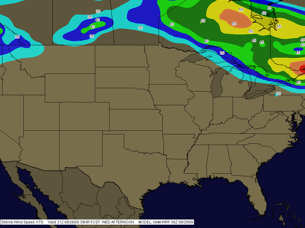
Boy, is it ever summer. The day has dawned a glorious blue, with nothing in the way of convective mayhem in sight anywhere in the nation. Nothing but pop-up thunderstorms on the menu for today here in Michigan, and the 500 mb jet is like a limbo bar raised high enough for most of the CONUS to squeeze under.

SummerPattern

It’s what you expect this time of year, and it’s what we’re getting. The SPC’s long-range outlook is calling for possible troughing by the weekend, so maybe we’ll see a round of severe weather yet. Who knows. But I’m not making any plans. This is August. Might as well be January so we can get winter over and done with, except…well, there’s still always hope this time of year, and the late season to look forward to.

So why am I writing when there’s nothing to write about? Just to wish you a nice day. Enjoy this beautiful weather we’re having here, cuss the luck.

The Augmented Scale

…John Coltrane and Oliver Nelson brought [the augmented scale] to the masses in the late ’50s and early ’60s. In more recent years, tenor legend and bandleader Michael Brecker (who passed away in January of this year) made good use of the scale, and required that Mike Stern, John Scofield, Pat Metheny, and other guitarists who played for him over the years also know how to harness the pattern’s power.

–from “Secrets of the Symmetrical Augmented Scale” by Josh Workman, EQ online edition

If you want to lend a touch of mysterious, Eastern-sounding chromaticism, angularity, and symmetrical sequence to your solos, consider the augmented scale. I’ve dipped into this unusual, colorful scale from time to time, and lately, in spending more time exploring its sounds and possibilities, I’m becoming captivated with what it has to offer.

The augmented scale is a hexatonic scale–that is, it only has six tones. It is also, like the diminished and whole tone scales, a symmetrical scale. This means that the interval relationships between scale degrees are repeated to create a symmetrical pattern. In the case of the augmented scale, moving upward from the tonic, the scale intervals are: minor third, minor second, minor third, minor second, minor third, minor second.

Here’s what that looks like on the staff.

C augmented scale

There are a couple easy ways to understand the augmented scale. One way, using the C augmented scale to illustrate, is to think of approaching each note of a C augmented triad with its leading tone–i.e. the note B leads to C, D# leads to E, and F## ( or more simply, G) leads to G#. Note that while in this approach you begin with the note B, the actual tonic of the scale is C.

Another way to picture the augmented scale is to superimpose two augmented triads with roots a half-step apart, then organize the resulting tones linearly in a scale. In the case of the C augmented scale, you would superimpose C+ on top of B+. Again, the actual tonic of the scale is C.

A variation of this approach is to superimpose two augmented chords with roots a minor third apart from each other. To get a C augmented scale, you would superimpose Eb+ (same as D#+) on top of C+.

As is also true of the diminished and whole tone scales, the symmetrical nature of the augmented scale makes its root ambiguous. The repeated pattern of a minor third and minor second produces not just one, but three possible tonics separated by a major third. In other words, when you learn the C augmented scale, you’re also learning the E augmented and G# augmented scales. This means that when you’ve learned the C, Db, D, and Eb augmented scales, you’ve learned all the rest as well. Nice, eh? You get all twelve scales for only a third of the work!

There’s plenty more to say about the augmented scale, but I’m not going to try to cover it all here. Dig inside the scale and discover its possibilities for yourself. Here’s a simple pattern to help you get started. The pattern is in C (and E, and G#/Ab). Memorize it, then transpose it to Db, D, and Eb.

C augmented scale pattern

Oh, yes–lest I forget, you’ll want to know how to apply the augmented scale. I’m still working that out myself, but here are a few pointers. Use the C augmented scale with
* a C+ or CM7.
* a C7 or C+7, but watch how you handle the #7. The chromatic tones can be viewed as passing tones, or they can become upper extensions if you alter the chord.
* a B7(b9) or B7 altered chord.
* an Am, Am6, or Am#7 chord.

You can also use the augmented scale with “Giant Steps” the same way you’d use a blues scale with the blues. But that’s a separate post.

This scale doesn’t come easily, but it’s well worth acquiring. However, it’s a more advanced study. You’d be wise to make sure you’ve got your basic major and minor tonalities down, including your cycle of dominants and ii-V7-I patterns, before you go digging into the more abstract stuff. Just my opinion. Take it with a grain of salt as you find your own way. Whatever you do, keep practicing–and have fun!

Whoops! Lost My Header!

Prior to making my last post, I downloaded the latest version of WordPress, and now I see that in the process I lost my header.

Not to worry–I’ll get it back soon. Or perhaps you’ll see the upcoming, all-new theme instead. Either way, please bear with me and I’ll get the blog all pretty-fied for you again real soon. Meanwhile, stay tuned. Hopefully you’re here because you like the quality of the content, and that hasn’t changed.

Cheers,

Bob