March 15, 2012, Dexter and Lapeer, Michigan, Tornadoes

Thursday’s tornadic supercells in eastern Michigan took a lot of people by surprise–NWS and media meteorologists, the SPC, storm chasers, and certainly me. Nothing about those anemic mid- and upper-level winds suggested the potential for even weak tornadoes, let alone significant ones. But there’s no arguing with Nick Nolte’s fabulous footage of the Dexter tornado, and certainly not with the damage that storm did as it swept through the town. It has been rated an EF-3, the most damaging of the three tornadoes reported on March 15, 2012. Second in impact was a tornado that struck farther north in Lapeer, causing EF-2 damage; and finally, an EF-1 tornado in Ida.

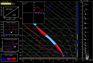
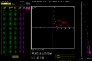
Like every other chaser in Michigan whom I know, I had no plans for chasing storms Thursday. True, temps were in the 70s and dewpoints in the 60s; MLCAPE was in the order of 3,000–3,500 J/kg; and the hodograph looked curvy.

But curvy alone isn’t supposed to cut it, not when the dynamics are as puny as they were: winds around 20 kts at 850 mbs; 20–25 kts at 700 mbs; and 25–30 kts from 500 mbs on up to around 26,000 feet, where they finally began to make incremental but hardly impressive gains. The storms that formed should have been popcorn cells that quickly choked on their own precipitation. But they didn’t. At least some of them became classic supercells that lumbered across eastern Michigan at around 15 miles an hour, spinning up strong tornadoes.

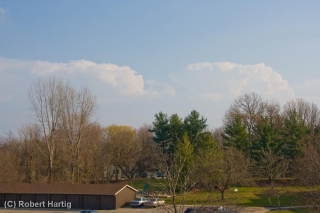
I was sitting in my living room editing a book manuscript shortly after 5:00 when I happened to glance out the window and saw some impressive, well-formed towers to my southeast. “Dang!” I thought. “Those look nice!” My second thought was to grab my camera and snap a few photos. After all, thunderstorms just aren’t something you normally see on March 15 in Michigan, let alone such muscular-looking ones. You can view one of the three shots I took–the last one, time-stamped 5:22 p.m.–at the top of the page. (Click on the image to enlarge it.)

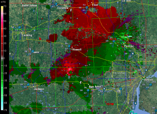
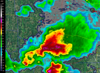
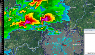
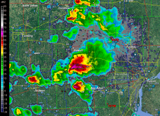
Curious, I took a look at GR3. I’d been glancing at it off and on as the afternoon progressed, watching a small squadron of cells pop up across southern and eastern Michigan. They resembled something I might normally see in July or August. But now, one of them looked different–so unexpectedly different that I had a hard time believing what I was seeing. South of Howell and northwest of Ann Arbor, the most vigorous-looking storm of the bunch had transformed into an unmistakable supercell–a regular flying eagle with a little pinhole BWER in the hook.

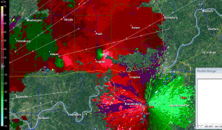
Where the heck did that come from, and why on earth was it there? Pinch me, I must be dreaming. I switched to SRV, and sure enough, there was a couplet, and not just a weak one, either. A pronounced couplet.

A scan or two later, the storm was continuing to develop. The pinhole had disappeared, and the supercell now had a classic hook. On radar, it looked as nice as anything you could hope to see out West in May–only this was Michigan in mid-March.

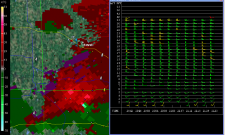
Surely the winds had to be better than I had been led to believe. One way to find out. I pulled up the VAD wind profiler at DTX. Ummm … well, okay. Nothing at all remarkable there. Maybe, given the curviness, enough bulk shear to organize the storm. Obviously that had to be the case; the evidence was staring me in the face, along with a couplet which hinted at the tornadic action that was presently occurring. The last screen capture, just below and to your right, shows both the couplet and the VAD. Enlarge the image, zoom in on it, and you can see for yourself just how meager the winds were and why one would expect storms forming in that environment to drown themselves in their own tears.

While I was glued to my radar in Caledonia, across the state storm chaser Nick Nolte was hot on the storm and videotaping the tornado that eventually hit Dexter. After getting out of work for the day, Nick had noticed the storm popping near where he lives. Grabbing his gear, he took off on what turned out to be one of the most serendipitous chases any chaser could hope for.

Nick got some fantastic footage of the Dexter tornado. Congrats, Nick–you really nailed it! Rather than steal Nick’s thunder by embedding his YouTube video here, I’m going to simply redirect you to his site and let you hunt it up there.

I’ve viewed some other footage beside Nick’s that demonstrates a particularly noteworthy aspect of the Dexter tornado, and that is its breakdown into helical vortices. I’ve seen only one other video that demonstrates this helical structure so clearly, and that is the famous KARE TV helicopter video of the July 18, 1986, Minneapolis tornado. The Dexter footage isn’t as dramatic, but it nevertheless depicts the helical effect with stunning and captivating clarity. Nick’s video captures it as well toward the end of his clip. It’s really amazing to see.

Unfortunately, the Dexter and Lapeer storms did considerable damage. If there’s a bright side to their human impact, it’s that no one was killed or seriously injured.

What turned yesterday’s anemic setup into a significant tornado-breeder? A weak upper-level impulse provided the needed lift to spark the storms, but it doesn’t explain why some of them developed into tornadic supercells, given the lackluster mid- and upper-level winds. I’m no expert, but I’m guessing that the unseasonably high CAPE is what did the trick. I suspect it took what was present in terms of shear and helicity and amplified it, in effect creating the Dexter, Lapeer, and Ida storms’ own mesoscale environments–ones conducive to tornadoes.

Of course, similar scenarios typically provide no more than single-cell and multicell severe storms. But then, yesterday was an anomaly in some significant ways. After all, this is Michigan, and it’s only mid-March. When CAPE of that magnitude shows up in the midst of unseasonably high dewpoints, it appears that all bets are off.

ADDENDUM: Lest you should miss reading the comments, check out this satellite loop from Thursday. You can see the storms exploding along an outflow boundary pushing west-northwest from Ohio, and other storms firing along a cold front dropping southeast. Two boundaries, and they actually appear to collide around Saginaw. The OFB accounts nicely for convergence and low-level helicity. Thanks to Rob Dewey for sending me the link.
Stormy Monday in Michigan?

The Storm Prediction Center’s Day Three Convective Outlook has stamped lower Michigan with a “See Text” attended by the following discussion:

A POCKET OF COLD
TEMPERATURES AT MID LEVELS…MINUS 18-20C AT 500 MB…WILL SPREAD
ACROSS LOWER MI JUST NORTH OF A FOCUSED SPEED MAX. THIS FEATURE
WILL LIKELY INDUCE DIURNALLY ENHANCED CONVECTION AS 50F+ SFC DEW
POINTS SURGE NWD WITHIN THE WARM CONVEYOR. LATEST FORECAST
SOUNDINGS SUGGEST SFC-BASED CONVECTION IS POSSIBLE WITHIN A STRONGLY
SHEARED ENVIRONMENT THAT WOULD OTHERWISE FAVOR SUPERCELL
DEVELOPMENT. GIVEN THE SOMEWHAT LIMITED BOUNDARY LAYER MOISTURE
ACROSS THIS REGION WILL NOT INTRODUCE HIGHER SEVERE PROBS ATTM.
HOWEVER ANY UNDERESTIMATION IN LOW LEVEL MOISTURE WILL LEAD TO A
MORE UNSTABLE AIR MASS THAT WOULD SUGGEST AN INCREASED RISK OF
SEVERE FROM EXTREME NRN IND/NWRN OH INTO LOWER MI.

Hmmm…okay, that’s worth looking into, and I have done so. The NAM surface map is more optimistic about moisture than the GFS and SREF, wanting to bring in mid-to-upper-50s surface dewpoints, and therein lies the possibility for severe, from what I can see.

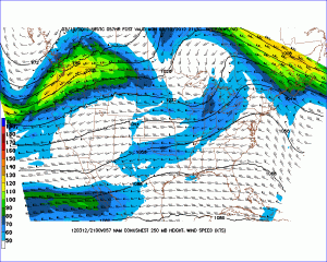
Today’s 12z 250 mb 4km NAM also shows a 70 knot jet streak moving into the area on top of 35-40 knot 850 mb winds, and GFS is in better agreement with the shear than it is the moisture.

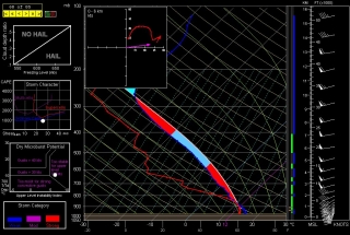
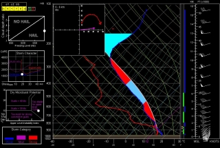
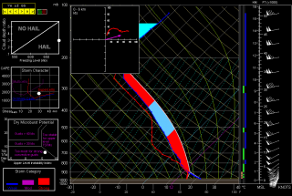
Earlier on, I also sampled a few 6z Bufkit NAM soundings using RAOB, and these show impressively curved hodographs–a different story from TwisterData’s point-and-click hodos–as well as dewpoints tapping on 60 degrees. That seems pretty exuberant, particularly in the light of other forecast models, but it does give me at least this take-away wisdom: Monday bears keeping an eye on. If, as the SPC states, decent moisture manages to infiltrate lower Michigan, then we could be in for some severe storms.

Just for kicks, below are the aforementioned RAOB forecast soundings for Monday evening taken from this morning’s 6z NAM run, along with the 4km NAM 250 mb map. The soundings are for Kalamazoo, Jackson, and Fort Wayne. Take them with a grain of salt, but let’s see how things shape up (or not) between now and then.

KALAMAZOO, MI

JACKSON, MI

FORT WAYNE, IN

250 MB WINDS (FCST 21Z)

Intercepting the March 2, 2012, Palmyra-Henryville-Marysville, Indiana, Tornado

Now, while my video from Friday’s chase is uploading to YouTube, is a good time for me to write my account of how things transpired down in southern Indiana.

The phrase “historic event” rarely describes something good when applied to severe weather. March 2 may qualify as a historic event. The current NOAA tally of tornado reports stands at 117; the final number, while likely smaller once storm surveys have been completed and multiple reports of identical storms have been consolidated, may still set Friday’s outbreak apart as the most prolific ever for the month of March. Whether or not that proves true, Friday was unquestionably a horrible tornado day that affected a lot of communities from southern Indiana and Ohio southward.

The Storm Prediction Center did an excellent job of keeping track of the developing system, highlighting a broad swath of the eastern CONUS for a light risk in the Day Three Convective Outlooks and upgrading the area on Day Two to a moderate risk. On Day One, the first high risk of 2012 was issued for a four-state region that took in southern Indiana and southwest Ohio, most of Kentucky, and north-central Tennessee–a bullseye in the middle of a larger moderate risk that cut slightly farther north and east and swept across much of Mississippi and Alabama as well as northwestern Georgia.

The SPC and NWS offices weren’t the only ones keeping vigilance. Storm chasers across the country were watching the unfolding scenario, among them being my good friend Bill Oosterbaan and me. Here are the February 29 00Z NAM model sounding and hodograph for March 2, forecast hour 21Z, at Louisville, Kentucky. (Click on the images to enlarge them.) With MLCAPE over 1,800 J/kg, 0-6 km bulk shear of 70 knots, and 1 km storm-relative helicity at 245 m2/s2, the right stuff seemed to be coming together. By the time the storms actually started firing, those figures were probably conservative, particularly the low-level helicity, which I recall being more in the order of 400 m2/s2 and up. Simply put, the region was going to offer a volatile combination of moderate instability overlaid by a >50-knot low-level jet, with a 100-plus-knot mid-level jet core ripping in.

I had my eyes set on southeastern Indiana. The problem with that area is, it’s lousy chase terrain along the Ohio River, and it doesn’t improve southward. If there was an ace-in-the-hole, it was Bill’s knowledge of the territory, gleaned from his many business trips to Louisville.

We hit the road at 7:15 that morning, stopping for half an hour in Elkhart so Bill could meet with a client and then continuing southward toward Louisville. Bill was of a mind to head into Kentucky, where the EHIs and CAPE were higher; I was inclined to stay farther north, closer to the jet max, the warm front, and, presumably, stronger helicity. But either choice seemed likely to furnish storms, and since Bill was driving, has good instincts, and knows and likes western Kentucky, I was okay with targeting the heart of the high risk rather than its northern edge.

But that plan changed as we drew near to Louisville. By then, storms were already firing, and one cell to our southwest began to take on a classic supercellular appearance. Bill was still for heading into Kentucky at that point, but after awhile, a second cell matured out ahead of the first one. We now had two beautiful, classic supercells to our southwest, both displaying strong rotation. It was a case of the old adage, “A bird in the hand is worth two in the bush”–except in this case, there were two birds, back to back. And I-64 would give us a clear shot at both of them.

So west we went, and into chase mode. At the Corydon exit, we caught SR 135 north, headed for an intercept with the first supercell. The two radar captures show the base reflectivity and SRV shortly after we began heading up the state road.

A few miles south of Palmyra, we got our first glimpse of a wall cloud maybe four miles distant. That’s all there was at that point, and the hilly, forested terrain afforded less-than-optimal viewing. Within a minute or two, we emerged into an open area just in time to see a funnel descend from the cloud. Tornado!

The sirens were sounding in Palmyra, providing an eldritch auditory backdrop to the ropy funnel writhing in the distance as we drove through town. The tornado went through various permutations before expanding into a condensation cone revolving like a great auger above the treeline. It was travelling fast–a good 60 miles an hour, at a guess. As we sped toward it, the condensation hosed its way fully to the ground and the tornado began to broaden. It crossed the road about a half-mile ahead of us, continuing to intensify into what appeared to be a violent-class tornado with auxiliary vortices wrapping around it helically.

Shortly after, Bill and I came upon the damage path. We pulled into a side road lined with snapped trees, amid which a house stood, somehow untouched except for a number of peeled shingles. The tornado loomed over the forest beyond, an immense, smoky white column wrapping around itself, rampaging northeastward toward its fateful encounters with Henryville and Marysville.

The time was just a few minutes before 3:00 eastern time. While I prepared and sent a report to Spotter Network, Bill turned around and headed back south. We had another storm to think about, and it was closing in rapidly. It wouldn’t do to get caught in its way.

Back in Palmyra, we headed west and soon came in sight of another wall cloud. This storm also reportedly went tornadic, but it never produced during the short time that we tracked with it. We lost it north of Palmyra; given the topography, the roads, and the storm speed, there was no question of chasing it.

From that point, we headed south across the river into Kentucky to try our hand at other storms, but we saw no more tornadoes, nor, for that matter, much in the way of any serious weather. Not that there weren’t plenty more tornado-warned storms; we just couldn’t intercept them, and after giving it our best shot, we turned around and headed for home.

Lest I forget: my worst moment of the chase came when I couldn’t locate my video of the tornado in my camera’s playback files. It seemed unfathomable that I could have horribly botched my chance to finally capture decent tornado footage with my first-ever hi-def camera. After being miserably sidelined during last year’s record-breaking tornado season, the thought that I had somehow failed to record this day’s incredible intercept just sickened me. Fortunately, there were no sharp objects readily available; and better yet, the following morning I discovered that I had simply failed to scroll up properly in the playback mode. All my video was there, and it was spectacular. Here it is:

My excitement over the video was offset by reports of just how much devastation this tornado caused eighteen miles northeast of where it crossed the road in front of Bill and me. Henryville, obliterated. Marysville, gone. Eleven lives lost in the course of that monster’s fifty-two-mile jaunt. And similar scenarios duplicated in other communities across the South and East. The death toll for the March 2 outbreak presently stands at around forty.

In the face of a mild winter and an early spring, Friday was the inauguration for what may be yet another very active severe weather season east of the Mississippi. We can only hope that there will be no repeats of last year’s wholesale horrors. May God be with those have lost loved ones and property in Friday’s tornadoes.

Tornado Weather Enters with 2012 Meteorological Spring

Today is the first day of meteorological spring, and while March is poised to come in like a lion, there may be nothing lamb-like about its exit. Not if these past few days and tomorrow’s setup are any indication of what to expect.

Tuesday saw 25 tornadoes in Nebraska, Kansas, Missouri, and Illinois, with several fatalities. Wednesday logged another ten in Indiana and Kentucky. Today is another light-risk day, and tomorrow the SPC has outlooked a large swath from southern Indiana and Ohio down through Kentucky and Tennessee to northern Mississippi and Alabama in a moderate risk.

Like most storm chasers, I’ve been watching this system for several days. Typical of early-season setups, it will be a dynamic system driven by crazy upper-level winds and a strong low-level jet overspreading weak to moderate instability. With this kind of setup, 500 J/kg CAPE can get the job done. But with storm motions this fast, intercepting them will be more like a skeet shoot than a chase.

Regardless, I expect to head out tomorrow for my first chase of the year. I’ve been casting my eyes on southeastern Indiana and southwestern Ohio, not far south of where the peak 500 mb jet energy will be nosing in. I notice that the latest NAM is a bit more conservative with instability, nudging it southward, so I guess the question is, how far south does one want to travel for this kind of fast-moving system? Probably not very. I don’t see the point of going after fast-moving storms in Kentucky or Tennessee in hilly, woodsy terrain that obscures the view. That’s a discussion point with Kurt and Bill, since the three of us will likely chase together.

This looks to be a dangerous situation across northern Dixie Alley. Crossing fingers and hoping for minimal impact on communities tomorrow afternoon into the night.

An Interview with Shane Adams, Part 2: Thoughts on Target Selection, Memories of the Greensburg Storm, and Reflections on Top Three Chases

In Part One of my interview with veteran storm chaser Shane Adams, Shane recalled his formative years as a chaser in a simpler time when laptops, mobile data, and the media hadn’t transformed the landscape of storm chasing.

Part Two begins with several questions that deal with more pragmatic matters of forecasting and target selection. From there, Shane recalls his experience with the deadly May 4, 2007, Greensburg supercell. It’s a unique perspective on the storm in its post-Greensburg phase as it continued to spin off massive, violent wedges, and Shane’s account includes a haunting encounter with Macksville police officer Tim Buckman shortly before he was fatally injured by one of the tornadoes.

Finally, Shane reflects on the top three chases of his career and tells why he considers them so.

Question: I just finished listening to an interview with David Hoadley on the High Instability podcast, and I was struck by the similarity between some of what he had to say and your own comments [in response to my last question in Part One]. Realistically, chasing continues to evolve; yet I resonate with your gratitude for having come up in a simpler time when there was nothing to detract from the supreme value of the storm and the sky. I’d imagine—correct me if I’m wrong—that today you use at least a laptop and GR3 on your chases. But I get that you’re a minimalist at heart. Let’s talk about what a chase looks like for you these days. First, what is your process for forecasting? What things do you look for in picking your target?

Shane: These days, I use the same computer models all other chasers use. Within that, of course, there are several different sources. Personally, I use the College of Dupage computer model website. The reason why is, most model pages use CONUS maps. I don’t like CONUS maps because they make individual states and regions too small for detailed analysis in my opinion. CoD uses regional maps, which are much easier to analyze down to the mesoscale and even microscale level. It’s important for me to be able to recognize a specific area within a state while looking at model data, so I can overlay in my head the actual spot where I believe all the ingredients will come together. Looking at a CONUS map, I might be able to say, “Yeah, southwest Oklahoma looks good,”  but I can’t tell exactly where in southwest Oklahoma I need to be. The difference between a career day and a bust can be as little as twenty or thirty miles, something that is impossible to pinpoint using CONUS maps. So definitely College of Dupage is my forecasting lifeblood. When their site is down, I am not happy LOL.

As far as a target is concerned, again, I’m pretty much like everyone else. You want the basic four of course: moisture, instability, wind shear, and a source of lift. I tend to gravitate toward instability, with slightly less attention to wind shear. I’ve not had much luck chasing highly dynamic systems with low instability, so those are a big turnoff for me when looking at a forecast. Also, those type setups typically have very fast storm motions, making chasing more difficult. With more focus on instability and less on wind shear, I try to find an area with the most explosive potential for upward motion in a place where storm speeds won’t be as fast (lack of intense shear). Of course this dream scenario rarely unfolds in reality as often as I’d like, but in any chase setup, I will always first target the area of greatest instability and fine-tune from there based on other parameters.

Q: If you were to head out into the field without the benefit of Internet, equipped only with your morning forecast and the knowledge you’ve gained over the years, how would situational awareness inform your decisions as the afternoon progressed? In other words, how might simply looking at the sky or observing changing conditions tell you that you’re in the right spot—or, conversely, that you need to move?

S: One built-in advantage of cutting your chasing teeth in central Oklahoma is, 99 percent of the time the dryline is west of you. This means that you wake up in the warm sector on most days and simply have to drive west until the clouds thin out.

Drylines are marked visually by a sharp decrease in cloud coverage, vertical height, and base level. Bases will rise, tops will flatten, and the overall number of clouds will decrease as you approach the dryline. This was one of the first lessons I learned; the scenario was nearly automatic each time I chased because I never woke up on the dry side of the dryline.

Warm fronts are perhaps even more pronounced visually, as north of them on many chase days, there will be a solid overcast of low clouds. These clouds begin to thin as you near the warm front, and then as you move south there are fewer and fewer clouds until you’re in clear sunshine—plus whatever early-bird towers are trying to build in the warm sector.

My targets usually put me near either a dryline or warm front, so my biggest visual clues are simply watching how clouds behave.

Q: Storms are firing and you’ve got multiple options. Without using radar, how would you determine which storm you’ll go after?

S: Usually when faced with having to choose from multiple storms, it’s right after initiation, and every storm has the same potential to become tornadic. Because of this, I almost always opt for the storm I have the best position or approach angle on. Sometimes it works, sometimes it doesn’t.

In other situations where you’re a good distance from the storms and they’re in different directions from you, you have to analyze the situation more closely based on storm history and the immediate environment. If, for instance, I’m thirty miles south of the triple point, and I have a storm north of me right on the triple point and another one forty miles south of me, then I have to consider certain things and do a quick pro/con list for each storm in my head: the north storm is closer, but it’s moving away … the south storm is farther away, but it’s moving towards me … but the north storm will have better helicity sitting right on the warm front, so there’s a better chance it could produce a tornado … but it could also cross the warm front into the cool side and become elevated before I get to it … so the south storm seems like the way to go … but I’m going to have to punch through the entire core to get a view … these are not easy decisions, and they must be made quickly. I’ve been right, I’ve been wrong, but the worst situation is when you’re indecisive and end up missing both because you took too long to commit to one or the other. I’m much better off just sticking to my target, driving there, and letting the situation unfold … instead of just driving to a general area and waiting until after initiation to pick a storm.

Q: You were among those who chased the Greensburg storm. Describe your experience.

S: In all reality, we busted on this day. By dusk, we were well north of the Greensburg storm as it developed, and had already thrown in the towel and stopped for food. Because I chase to get good tornado video, I always quit after dark unless I’m already on a tornadic storm. So we’d been sitting in the Great Bend Pizza Hut drowning our sorrows with a large Meat Lover’s and Bud Light.

On a whim, Mick Ptak, the friend I was chasing with, had decided to bring his laptop inside “just in case” to watch the radar. We’d never done this before, so the fact that he’d chosen this night was, in hindsight, very lucky and ironic; if he hadn’t done so, we’d have sat there eating and missed the entire event. Or even worse, been in the path of more deadly storms well after dark.

Somewhere during beer number two, we both glanced over at the radar. Mick had been running a velocity loop, and the couplet we were looking at was off the charts, like nothing we’d ever seen before. We immediately went into chase mode, with Mickey grabbing all the gear while I ran to the counter to pay for the meal. I asked if the tab was below $20, and when the person said that it was, I just threw a twenty at them and ran out the door.

We raced south while listening to live reports coming over NOAA radio. It was obvious something terrible had happened in Greensburg, although neither of us at the time had any idea of the magnitude.

We got to Pratt, which is about thirty miles east of Greensburg, and turned west. We stopped near Haviland, where we began our actual “chase” of the Greensburg storm. I remember scores of emergency vehicles screaming by us for several minutes, all headed west from Pratt. The scanner was alive with constant chatter regarding the disaster that had just happened. We were using the velocity loop on radar as our main source of info, because the lightning wasn’t helping out as much as we needed. The first of three giant tornadoes we would observe that night loomed to our northwest, buried in darkness and probably precipitation. We were sure we were looking at a tornado, but it was so big and so hard to see, it was impossible to make it out clearly (it would be partially revealed in a capture from my video). The inflow was so incredible, I had to wedge myself against the open car door space while leaning against the door to keep it from closing on me. We moved back east and then north once the storm started moving further away.

Watching the radar, we were noticing alarmingly large spaces between mesocyclone occlusions. Not only were these couplets incredibly powerful, they were also unbelievably huge. It made sense that the “handoff” distance between mesos would be greater than normal as well, because the mesos themselves were so unusually large. Normally, five miles southeast of an ongoing meso/tornado is a reasonably safe distance, but not tonight. We kept a minimum of about seven to eight miles between us and the tornadoes for fear of being run over by the next cycle jumping toward us. Unfortunately, later that night, a local LEO would become an example of how these large-span meso jumps can be lethal.

As we continued north, we met a car coming south, frantically flashing its lights. At this point, with this storm and what it had already done, we weren’t taking any chances, so we turned around and headed back south. No sooner had we done so than Mick said, “There’s a huge wedge back there!” I stopped the car and we jumped out. I hadn’t yet seen it, but I could tell by Mick’s reaction that it was big. A few more seconds passed by, then a big flash of lightning lit up one of the largest tornadoes I’ve ever seen. “Whoah, I see it!” We held our ground and watched this huge wedge tornado through intermittent lightning flashes for a couple of minutes, then continued further north.

We stopped a few miles south of Byers, and a police car pulled up beside us. We didn’t know it at the time, but the driver was Officer Tim Buckman of the Macksville police department, a neighboring town to Byers about ten miles north and slightly west. We told him about the large tornado we’d been seeing off and on for the previous ten or so minutes, and he was already aware of it. He continued on ahead of us, and we followed him into town. Once we arrived in Byers, we saw Officer Buckman pulled over at the fire station, talking to a few firemen/spotters. As a courtesy, we stopped and asked him if he minded if we continued on ahead to chase the tornado. He said we could, but it was “at your own risk.” We told him we understood, thanked him, and drove north of town about a mile, where we stopped.

We continued to get glimpses of the tornado, and after a while, Officer Buckman drove past us. He went about a mile or so north, then turned west. The tornado was well off to our northwest, and the area he was driving into would’ve been a prime spot for the next tornado if the storm recycled. I remember thinking, as I videotaped his flashing red and blues moving slowly off toward the large tornado in the distance, “I wouldn’t go that way.”

As Tim Buckman’s emergency lights faded off into the darkness to our north-northwest, we became focused on a new area that was north of us, but closer than the previous tornado had been. Matching up what we were seeing to the radar, we were convinced this new area was the next probable tornado, southeast of the now dissipating tornado near Macksville, some ten miles to our north-northwest. We stayed put where we were, partly because we were almost out of gas at this point, but mostly because we were too spooked to get any closer. After a few more minutes, another large tornado became partially visible with lightning strikes. The eastern edge was buried in rain, but the west side of this monster loomed quite clear, a solid wall of black. We sat and watched this tornado, which was south of St. John, for maybe five minutes until we could no longer make it out. After that, we decided we’d call it a night, because we had another chase looming the next day, and we’d need some rest (though we hardly got any).

I don’t know why we even thought we could, but we drove back to Pratt, and managed to get a room at the first hotel we stopped at. I spent all night going over my video, finding bits and pieces of tornadoes within the lightning strikes. I wrote a report on Stormtrack while the local television news was showing us the first shots of the Greensburg monster we’d seen—incredible. The sirens never stopped all that night, with constant emergency vehicles driving to Greensburg and driving back from there with injured. It was a very dark and brooding night, probably the most unsettling night of my chase career. Since then, I’m much more wary about after-dark chasing. I was never very interested in nocturnal chasing, because night-time video is rarely worth the effort in my opinion. However, the significance of this event made the endeavor very worthwhile, and in the process, we managed to get video of tornadoes that nobody else did. What at first seemed like a curse actually became a blessing of sorts; we’d missed the marquee tornado of not only the event, but the entire year—but we’d managed to pick the storm up where almost everyone else had lost it, getting trapped by the devastation in Greensburg. The result was observation and video documentation of large tornadoes that no other human eyes ever found.

A few days later, unfortunately, we learned that a Macksville police officer had been killed by a tornado east of there. As it turned out, the officer killed was the one we’d spoken to that night during the Macksville tornado. He had made his way through rural areas just southeast of his hometown to get back to the highway east of Macksville so he could observe the large tornado threatening his community. Tragically, the last tornado we saw, from the same spot where we last saw officer Buckman driving northwest towards the Macksville tornado, formed south of his position, and struck him as he moved east on highway 50, critically injuring him. He would succumb to his injuries a few days later. We were likely the last ones to ever see him before this tragic event.

Q: Granted this may be a hard question to answer, but what has been your most outstanding chase, and what made it so?

S: I measure greatness in a chase by multiple factors: number of tornadoes seen, quality of tornado video, historical significance of the event, and overall aesthetic/sensory/spiritual experience. Even with that, I cannot choose just one day. So using the formula I described just now, I’ll try to narrow it down to just one event that fits each category.

Number of tornadoes seen: Even though it’s tied for second all-time for the most tornadoes I’ve seen in one day, I would have to give the nod for most tornadoes to May 29, 2004. Great video, but what stands out most about this day for me is the sheer number of visible tornadoes. Every size and shape imaginable, with the most incredible display of tornadic behavior I’ve ever witnessed: Multiple tornadoes merry-go-rounding about the parent mesocyclone. Tornadoes zigging, zagging, and doing full circles. Absolutely incredible!

Quality of tornado video: This category belongs to June 12, 2004. The infamous “glowing” Mulvane tornado steals the show from this event, but all the tornadoes that day were very photogenic, and I was able to capture incredible video of them all. This day is the bar for what I expect to bring home on video every time out. Mulvane was the first tornado I ever heard the roar from.

Historical significance: If we’d actually seen the Greensburg, Kansas, tornado that night, this would’ve likely been my number-one. However, May 3, 1999, remains at the top of this category. Many firsts happened for me that day: first F5 tornado, first 3+ tornado day, first double-digit tornado day (ten tornadoes), first up-close tornado encounter (less than a half-mile), and unfortunately, my first killer tornado.

I almost doubled my career total on this day. I had been chasing a little under three years at the time, and though I’d seen some tornadoes, I had never seen a day even close to this. Despite the dark cloud that hung over this event because of the of the human tragedy it brought, yet for me as a chaser, the sheer magnitude of what we’d seen and captured on video was almost overwhelming. That whole week was surreal: getting calls for interviews, having television crews at our apartment taping shows, the whole nine yards. The week after May 3, 1999, was as close as I would ever come to money and fame as a chaser. I appeared on television in both America and Germany (the German show actually aired first, so my TV debut was international LOL), and made $2,100 from video sales. There were no brokers in 1999. I had to fight those bloodthirsty wolves on my own, and in the end, despite the fact that I won the war, I decided the battle scars just weren’t worth $2,100. My television and video sales career began and ended that week.

Overall aesthetic/sensory/spiritual experience: Hands-down, this category goes to October 24, 2010. This was a day that brought back that old “chase first, forecast second” philosophy from my early years, but only because of my laziness. The only reason we even left the house that day is because Bridget Geaughan, my girlfriend/chase partner since 2008, was watching a storm explode just east of our apartment. We’d spent the previous two days busting on setups that, in my opinion, had looked better than this day. I wasn’t about to waste my Sunday on a third consecutive goose chase. However, Bridget pushed for us to chase and I caved.

Once we got out on the road after the initial storm she’d seen, it was obvious we’d never catch it. By now I was fully into chase mode, and I figured our only hope was to start heading southeast, cross the dryline, and hope like hell something new formed to our southwest. The plan worked to perfection, and we encountered the tornado of our lives in Rice, Texas. This chase has been well-documented in chasing circles, mostly because Bridget live streamed almost the entire lifecycle of the tornado. I’ll never forget looking up at the top of the funnel as it was in a near-steady-state, watching how the base seemed to get pulled into it like a bathtub drain. It was a view I’d not had before and haven’t seen since, but one I could get used to. Probably a once-in-a-decade type experience, maybe once in a lifetime.

———————–

Thanks, Shane, for an informative, thoughtful, moving, and overall terrific interview! To those of you who’ve read this far: check out Shane’s blog, Passion Twist. It’s aptly named–filled with insightful, detailed, and well-written chase logs; packed with photos; and stamped with Shane’s unquenchable love for chasing storms.

An Interview with Shane Adams, Part 1: Retrospectives and Perspectives on Storm Chasing Yesterday and Today

In recent years, due largely to the influence of Discovery Channel’s Storm Chasers series, storm chasing has exploded as an avocation. What began over fifty years ago with a handful of individuals roaming the American heartland in pursuit of nature’s most violent and beautiful storms has evolved into a hobby practiced by multitudes, shaped by the media, and facilitated by state-of-the-art technology.

Today, equipped with a laptop, a modem stick, and radar software, a beginning chaser has an excellent chance of seeing tornadoes right out of the starting gate. But it wasn’t always so. Once there was no GR3, no mobile data, no live streaming, not even any laptops—and nowhere nearly as many chasers as there are today.

New chasers conceive of storm chasing as it is, not as it was. That’s inevitable. People live in the present, not the past, and any of us can only board the train from the platform we’re standing on. Yet the past wasn’t all that long ago—that pre-tech era when the tools of the trade were few and the likelihood of busting far greater. Those of us who came up during those simpler times treasure the experience and carry a different perspective than those who cut their teeth on techno-chasing.

To scores of chasers who have been around the block a few times, Shane Adams needs no introduction. Shane has been a storm chaser since 1996. He’s well-known as a passionate and highly experienced chaser who lives, eats, and breathes storm chasing. With six storm chasing videos to his credit, Shane is the host of the weekly podcast The Debris Show; and, with his girlfriend and fellow chaser, Bridget Geaughan, he is the coauthor of the storm chasing blog Passion Twist.

Shane was good enough to do a written interview with me covering a broad range of topics of particular interest to storm chasers. The questions and responses range from the retrospective and occasionally philosophical to the practical.

Shane is an articulate, thoughtful, and passionate interviewee with much to share. Since the article is lengthy, I’ve broken it into two parts. In this first part, Shane talks about his personal development as a storm chaser; and, in the light of his own experiences, he reflects on the state of chasing today.

In part two, which I’ll release in another day or two, Shane talks about his personal approach to forecasting and chasing. He shares his unique account of chasing the tragic May 4, 2007, Greensburg, Kansas, supercell, and he looks back on the three most outstanding chases of his career.

Enough of my introduction. Here’s part one.

.

Interview with Storm Chaser Shane Adams

.

Question: Some background stuff to begin with. Talk a bit about your boyhood. You currently live in the Fort Worth, Texas, area. Have you lived in Tornado Alley all your life?

Shane: I was born in Oklahoma City and lived there until my parents divorced at age four. After the divorce, my mother and I moved to Healdton, Oklahoma, which is in the southern portion of the state. Growing up there for me was fun, because we lived in the same house for thirteen years, and I made many lasting friendships and knew the area well. We had a pasture that butted up to our neighborhood, and my friends and I would spend countless hours playing out there, back when kids actually played outside. That was pretty much my life pre-storms, although growing up in Oklahoma my entire life, I had been aware of storms as far back as I could remember.

Q: What event, or events, first served to flip the switch of your fascination with tornadoes?

S: As I mentioned, I had always known about thunderstorms. I can remember way back, first seeing this weird word they always used on television weather warnings: tornado. I knew about severe thunderstorms but had no clue what a tornado was. My mother tried to explain it to me, but her very limited knowledge and understanding, coupled with my young mind, just didn’t really paint the picture.

Then April 10, 1979, came along. A massive F4 tornado ripped through southern portions of Wichita Falls, Texas, just eighty miles southwest of Healdton. A few months later, one of the local television stations did a story on the tornado. I was in my room when suddenly my mother started yelling for me. I ran out into the living room, and she pointed to the television. I looked at the screen and saw a huge, black, boiling mass of cloud scraping along the ground below the most ominous sky I’d ever seen. “There,” she said. “That’s a tornado.”

I was hooked for life.

Q: It’s one thing to be intrigued by tornadoes; it’s another to actually chase them. When did you first start chasing, and what inspired you to do so? What was your first chase like for you?

S: I dabbled with chasing for years before I really started, but this was nothing more than glorified spotting. I would move from one edge of town to the other, but when the storms moved on, I never followed. I did this infrequently from 1988–1995.

On April 21, 1996, I went on my first true chase, where I actually drove out of town, over the road, to try and find a tornado. However, this too was a spur-of-the-moment thing, and I only had a cheap disposable camera and a cooler full of ice in case I found big hail. There was no plan, except that if I got into hail bigger than golfballs, I would back off, fearing a tornado I couldn’t see would be close behind.

I did get hail up to golfballs that day, saved a few in my cooler, and took a few snapshots I never developed. But this was nothing I would consider a real chase by my standards. To make it a real chase for me, there must be a video camera for documentation. Otherwise, it’s just a drive.

My first “official” chase was June 6, 1996. I was working a landscaping job with a friend of mine named Greg Clark. It started to get stormy early that afternoon, so we decided to knock off early. I said on a whim, “We should go chase these storms and try to find a tornado.” Greg not only liked the idea but suggested that we grab his mother’s video camera and tape the experience. It had never crossed my mind to actually videotape a tornado, but I was wild about the idea. (As it turned out, having the video camera that day was pivotal towards me becoming a chaser).

We grabbed the video camera, stopped by my place to look at a live update from one of the local television stations, and then took off towards a storm that was tornado-warned. There was no plan; we just called it as we went. All I knew at the time was, you want to be out of the rain, so we just drove right into the heart of the storm until the rain stopped. A lowering was to our south, so we turned east to pace it. We stopped, and I started shooting video. Literally seconds after I did, a small tornado formed out of nowhere, right in the spot I was pointing at, lasting less than a minute. It was pure dumb luck, but it was a critical moment for my chasing future.

Q: That first tornado obviously hooked you. What was your growth curve as a storm chaser like from that point?

S: I laughed out loud when I read this one. To put it simply, I was horrible. For years. I got by the first four or five years on sheer passion and tenacity. I didn’t know anything about the atmosphere or that I even needed to. Computer models were something I didn’t even know existed for the first year I chased. All I was armed with was an unrelenting, unrivaled passion to see tornadoes. There really was nothing else other than the minimal, basic structural and behavioral experiences I was slowly developing as I chased more and saw more.

As the years started going by, I started to recognize patterns and tendencies purely from what storms looked like or what the sky in general looked like. By my fifth season, I was pretty good at working a storm—meaning, how I handled it once I found it—even though I knew virtually nothing about finding storms. Basically, I learned how to chase storms way before I ever learned how to forecast them.

Q: Who were some of your key influences during those early years—people who helped you learn the ropes or who simply inspired you?

S: The first storm chaser I ever heard of was Warren Faidley. I received The Weather Channel’s Enemy Wind on VHS for Christmas in 1992 and wore the thing out. I had no clue there were people out there who actually chased storms seriously. But even more, I had no idea there were several people other than Faidley who had been doing it for years.

The first storm chaser I began to seriously follow and look up to was Jim Leonard. He was bigger than life to me. I was brand-new to chasing and just discovering the wonders of my storm chasing passion. Jim was the guy who, in my eyes, had done everything I wanted to do. His dedication to the art of chasing, and the fact that he’d started around the same age as I was and was still as dedicated well into his forties, was amazing to me. I idolized him, and I’m not the star-struck type. I met him briefly at a landspout seminar hosted by Al Pietrycha in Norman in 1997. I asked him a few questions about what was, at the time, my favorite intercept video from him: his June 8, 1995, Allison, Texas, wedge tornado. It was such a thrill to actually be standing next to my hero, although he had no clue who I was or that I worshiped him LOL.

Another chaser who, in my later formative years, really reached out to me was Gene Moore. He realized how ignorant I was but also saw my passion and dedication. While he could’ve easily ridiculed me, he instead took the time to talk to me about a few things he considered the basic, important essentials for storm forecasting. Things I still use to this day, every forecast, every chase.

Q: You came up in a time when technology and the media hadn’t yet shaped storm chasing the way they do today. What was chasing like for you in those days? What benefits do you think you gained from the minimalist, old-school approach that younger chasers today are missing?

S: The main difference between chasing now and chasing when I started is the laptop computer, but that’s over-simplfying things. Back in the day, we didn’t just not have computers, we didn’t have smart phones or iPods either. Today’s chasers never have to deal with long hours on the road the way chasers did years ago. Sure, twelve hours cooped up in a vehicle is still extreme, but it definitely softens the experience when you have constant entertainment at your fingertips, the way you would at home.

Chasers today don’t talk to each other, they chat. They stream. They surf. They listen to music. There will be a carload of chasers and each one will be in their own world, playing on a cell phone. Chasers today will never know what it’s like to spend twelve hours in a car when all you have for passing the time is conversation. And many times for me personally, I didn’t even have that, because many of my past partners were champion sleepers when there was nothing exciting going on. It takes a special kind of person to willfully strap themselves in for a ride that could last over twenty-four hours, with absolutely no guarantee of seeing anything—even less of a guarantee without constant streaming data 24/7 to lead you to the storm on a string—and absolutely nothing to pass the time. These techno-generation chasers will never experience that level of dedication, and quite frankly, if many of them were to, I doubt some would stayas dedicated.

Basically now, chasing is just people doing all the same things they would be doing at home otherwise, except there’s a drive involved and maybe a storm or tornado. The “grueling, long hours” which are so often brought up by chasers praising their allegiance to their craft are nothing more than what they do every day, except they have to stop to use the potty.

I’m very grateful I was able to endure the type of chasing I did for a good number of years. We would jump in a car and drive to Missouri or Illinois from Oklahoma on a whim, with nothing to guide us except NOAA radio. We were always broke, so hotels were an extremely rare treat at best, maybe once or twice a year. Normally we’d just drive in shifts, and do straight-through chases of twenty-four hours or more. And this was with no Internet, no Spotify, and no Angry Birds. Just a carload of guys who shared one common goal: to see a tornado.

One time in 2000, we left Norman at 1:00 a.m. and drove straight through to North Dakota only to miss all the tornadoes by forty-five minutes. We stayed the night in Fargo, then drove straight back the next day, missing even more tornadoes because we got there too late again. That was a 2000-mile, two-day trip for some thunder and lightning. We had several of those back in the day, when the only thing fueling us was the desire to simply see and videotape a tornado.

There are few of today’s new chasers who would ever willfully endure that type of experience. Kids today want everything on a plate, with a remote, a keystroke, or some other too-easy device designed for no other purpose than to make an already easy life that much easier. A lot of chasers like to toot their own horn (nice pun, eh?) about how dedicated, extreme, and hardcore they are. Doesn’t take much to drive 500 miles when you know you’ve got Internet the entire way and a nice, comfy hotel bed waiting for you that night. Try it with nothing but a NOAA radio and knowing that regardless of what happens, you’re not sleeping again until you get back home the following day. That’s hardcore.

But it’s a different world, and I have to accept that. I look around, and I really can’t relate to most newer chasers. They rely on electronics for their lifeblood, they care as much about making money as simply videotaping a tornado, and they’re all so busy trying to come up with the next big thing or gimmick. For me, at the end of the day, it’s about the storms and tornadoes, period. Streaming doesn’t matter, money doesn’t matter, and every other chaser out there doesn’t matter. All that matters is my video camera and that tornado in front of it. My day ends when the last tornado ends and the setting sun bleeds away. Their day is just beginning, hustling to contact brokers or potential customers with their day’s bounty. That’s fine for them, but chasing isn’t work for me. It can’t be, because I love it too much to ruin it by putting money at the top of the priority list. Everyone likes to deliver that famous line, “Hey, if I can get some money back that’s great,” but the reality is, once you taste money from chasing, it stops being about seeing storms and starts being about selling video. Because making $$$ from chasing is too much work for it not to be the top priority.

I’m happy fading back into obscurity, with my long resume filled with amazing catches the world doesn’t value because they haven’t been splashed all over the internet and television. I’m perfectly content to sit back and watch the flame wars, the ego battles, and of course, the constant brand/money wars. I watch this blur of an activity, as it is today, and smile inside, thinking back to how simple and innocent it was so many years ago. Even more simple and innocent years before my own career started. I’m proud to have come along when I did, to get a taste of the tail-end of a great era of storm chasing. There’s no doubt I’m the chaser I am now because of the way I learned, and that’s something I cherish. I haven’t seen the most or the best, been the closest, or lived through the worst, been the most famous or the most respected. I’m just doing my own thing the best way I know how, and will continue to trudge forward, ever-attempting to pen the next chapter in my life’s storm chasing adventure.

(Coming in Part Two: personal forecasting and chase approaches, the 2007 Greensburg storm, and top three career chases.)

The Noob: A Review of Adam Lucio’s New Storm Chasing DVD

June 17, 2010. If you were in Minnesota on that date, I need say no more. Regretfully, I was not there. But Adam Lucio was, and in his new DVD chronicling his chases from 2008 till today, Adam’s Minnesota chase–which rewarded him with some of the most visually stunning tornadoes of circum 2010–is just one in a list of potent tornado events captured on video.

No, it’s not the next best thing to being there in Minnesota–how could it be? What it is, is great footage of some spectacular storms, the kind of video that makes me wish like anything that I had been there and glad that Adam has done such a good job of showing me what I missed.

If for no other reason than the 2010 Minnesota outbreak, Adam’s DVD is a viewing windfall for storm chasers and weather junkies. However, June 17 is just one of a number of memorable chases that appear in The Noob. More recent footage from 2011 includes the dusty EF-3 Litchfield, Illinois, cone of April 19; a turbulent EF-4 wedge from the historic April 27 Super Outbreak; and the violent Oklahoma storms of May 24.

The Noob also whisks me down Memory Lane to May 22, 2010, in South Dakota, an unforgettable day for those of us who chased the northern plains. And heading back even further, Adam shares some visceral footage from 2008 of a large tornado crossing I-57 south of Chicago, his hometown.

At nearly two hours in length, Adam’s DVD covers a lot of material, and I’m not going to attempt a blow-by-blow analysis of it all. I’m just going to comment on a few highlights and let you discover the rest for yourself when you buy the DVD. Which you should do. You’ll congratulate yourself on your purchase every time you watch it.

I’ve already mentioned the Minnesota outbreak of June 17, 2010. This is the one section of the DVD where I took notes, because the storm was simply incredible. The video first shows an initial elephant trunk near Kiester. It’s followed by another much larger tornado, and from here the drama rapidly ramps up. I’ve heard some guys describe this date as their best chase ever, and I can see why: there’s a lot going on with both the tornadoes and the surrounding sky.

As the second, dark wedge does a multi-vortex dance on the other side of a distant woodlot, a new circulation rapidly develops in the foreground. There appears to be no handoff of energy from one circulation to the other at this point; for a while, presumably, two distinct, large tornadoes coexist in close proximity to each other. Eventually, however, we’re left with just one large, white cone surrounded by a huge, rapidly revolving collar cloud. The effect, already spectacular, becomes even moreso as the tornado moves toward Conger and then onward toward Albert Lea. It is a monstrous, long-track tornado that displays every shape and behavior in the book.

What at times captivated me as much as the tornado was the behavior of the clouds in the foreground. There’s at least one instance where you can see clear signs of anti-cyclonic rotation, both on a broader scale and in smaller swirls of cloud. It’s amazing to watch. And so is the horizontal vortex that passes overhead. The 1 km helicity near this storm had to have been just plain crazy.

Moving on, the Alabama footage is engaging not so much from a visual as a historical standpoint. Don’t misunderstand me, it’s good, entertaining viewing; it’s just nothing like the Minnesota section. What makes it remarkable is the date: April 27, the day of the 2011 Super Outbreak. Not since the infamous 1974 Super Outbreak have so many powerful tornadoes wrought such havoc in a single day. For that reason, this section of The Noob may be of historic interest in the future.

The May 22, 2011, South Dakota footage captures another spectacular, beautifully structured storm. What sets it apart, however, is the insanity of that a number of chasers experienced when the road they chose for an escape route dead-ended in a farmer’s wheat field. Adam was among them, along with his chase partners, Ben Holcomb and Danny Neal. With multiple tornadoes spinning up and advancing toward them, the chasers took the only evasive action they had left by bailing south into the field, where ponding eventually cut them off. “Game over,” as Adam put it. From that point, all they could do was hunker down and brace themselves until … well, you’ll just have to see for yourself what happened. Ben Holcomb captured the intensity of that part of the chase on camera, and Adam has included Ben’s video as part of the South Dakota section.

I might add, my buddies and I were in that same field just a stone’s throw from Adam’s vehicle, and I remember well how it was that day. But some of the footage here reveals things even I didn’t see, and viewing it makes me realize how truly blessed all of us were to have escaped without injury.

I could continue on, but you get the idea. The Noob is a great storm chasing DVD that delivers a huge amount of bang for your 14-and-99/100 bucks.

Adam is a passionate and capable chaser who takes every opportunity available to him to go where the storms will be. The title of his new DVD reflects to me both humor and humility, winsome qualities in any person.

The Noob is raw chasing. Adam clearly invested time and care in editing his material, and he offers a few nice editorial touches (such as Ben Holcomb’s embedded footage during part of the hair-raising South Dakota field escapade). For the most part, however, the DVD doesn’t get too fancy. In my book, that’s a plus. The occasional splashes of background music are conservatively used, not overdone, and hence a welcome addition rather than a subtraction from the focus of this video, which is tornadoes and the experience of chasing them.
.

Critique

Is there room for improvement? Sure. Much of the video footage is hand-held, which makes for slightly to drastically shaky viewing. Of course, this is real-life chasing–not a professional film crew, just one guy with a camera coping with constantly changing conditions as he pursues the most violent and volatile weather phenomenon on the planet. Some of the storms were clearly moving fast, and Adam didn’t have time to park his vehicle, set up his tripod, toss out a lawn chair, and sip his favorite beverage, iced tea, while casually filming. I noticed that he made better use of his tripod with slower moving storms. In any event, I’m pretty sure he has already been considering how he might get more stable shots next season.

My second comment: There were times when I wanted to see a continuing view of a tornado’s interaction with the ground, not the sky. In the Minnesota footage, a large wedge barely misses two farms, appearing to barely graze behind them. Yet the camera drifts away from the drama on the ground–it had to have been terrifyingly dramatic for the people living at those farms–to the cloud base, back and forth. There’s enough ground footage to give a good feel for what’s happening; still, I want the focus to remain on the lower part of the funnel as it sweeps past past human habitations, so I can dwell on the story unfolding there at the surface.

With those two critiques out of the way, the only question left is, do I recommend this DVD?

Are you kidding? Absolutely! Yes. Buy it. Watch it once, watch it again, watch it multiple times. This is killer stuff.
.

Purchasing Information

The Noob is 1 hour, 57 minutes long. Purchase price is $14.99 ($17.99 international). For more information and to place your order, visit Adam’s site.

Fall Meeting of the Michigan Storm Chasing Contingent

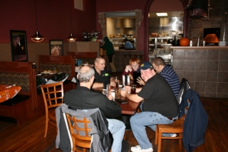
Last Thursday, October 27, the Michigan Storm Chasing Contingent convened at its favorite meeting place, the Walldorff Brewpub in Hastings. Present were L. B. LaForce, Ben Holcomb, Bill Oosterbaan, Tom Oosterbaan, Nick Nolte, and I, the unofficial recorder. The meeting was called to order, or at least something approaching order, and it was immediately moved that beer should be purchased. The motion was passed by five out of six, with one member abstaining. The recorder found himself in possession of a 24-ounce schooner of Cobain’s Double Dark IPA, which easily balanced out the abstention.

Truthfully, there is no official Michigan Storm Chasing Contingent. I made up the name. Membership dues have not been levied and cards have not been issued. The whole notion of a Michigan Storm Chasing Contingent is something of an oxymoron to begin with. Nevertheless, most of these guys have had a pretty impressive year, with plenty of miles logged and tornadoes observed. The sorriest mug in the lot was me, but I won’t go into that; 2011 is almost over now, and I’m done whining. The big thing is, Ben Holcomb was visiting from Oklahoma, and that seemed like a good reason for all of us to get together and hang out for the evening.

The Walldorff is becoming a tradition for us, and it’s not a bad one. The place has award-winning craft brew. The cuisine, made from scratch using local produce, meats, and dairy products, is also fabulous, but the beer is the main draw. Not that this is a hard-drinking bunch; they’re actually pretty conservative. But they do enjoy the Bee Sting Ale, one of the many superb craft brews turned out by Sam, the Dorff’s world-class brewmeister.

As for me, I opted for the Cobain IPA with its double-bitter blast of mega-hops and roast malt. It was the first beer I had ordered at the place since I joined its pub club a couple months ago, and I figured that it was time I finally took advantage of my member’s discount. I expected a nice price break. What I didn’t anticipate was the 24-ounce mug that the waitress set in front of me. It was big enough to generate its own lake breeze, and I could see surf breaking against the brim. Good grief. At 8.5 ABV, the Cobain is a potent brew, and all I wanted was a modest glass. I just can’t knock off such stuff with impunity anymore like I used to. Out of shape, out of practice, and getting older. Oh, well.

It was great to see all the guys, though we missed Kurt Hulst, who had to work. There’s nothing more interesting than storm chasers talking shop, at least as far as other chasers are concerned, and this year

afforded plenty of notes to compare. Ben, Bill, and Tom had been on the May 24 Chickasha tornado, a particularly violent beast that may be upgraded to EF-5. Seems that it pitched a Ford F-150 pickup truck 800 yards–nearly half a mile. It’s hard to fathom that kind of power.

But enough. It’s late, this recorder is tired, and it’s time I put this post to rest. Till next time, gents: L’chaim!

Book Review: Severe Storm Forecasting by Tim Vasquez

Beginning with his Weather Forecasting Handbook, which I purchased years ago at a College of DuPage severe weather conference, I’ve collected one-by-one nearly all of Tim Vasquez’s books on storm chasing and weather. The only exception is Tim’s most recent, 2011 publication, the Weather Forecasting and Analysis Handbook, and that’s next on my list.

The owner of Weather Graphics and the well-known storm chasing forum, Stormtrack, Tim is a widely acknowledged guru of storm chasing and operational forecasting, particularly in the severe weather arena. The man possesses more convective knowledge in his left pinkie than most of us do in our entire bodies, and in this fairly recent publication, he organizes information that is most relevant to chasers and severe weather junkies.

In Tim’s words, “Severe Storm Forecasting was a project started in 2007 to serve as the perfect companion for intermediate forecasters and a refresher for experienced forecasters. It maps the current state of severe thunderstorm forecasting from an operational framework rather than a research or academic perspective. Equations, physics, and lengthy citations have been kept to a bare minimum.” (From the preface.)

In other words, the book is intended to provide up-to-date, practical information that storm chasers can readily apply in forecasting and in the field. Since its release in 2010, I’ve been wanting to get my hands on this book. A while ago, I finally shelled out my $29.95 and purchased a copy, and I’ve spent the last several weeks chewing on it. It’s nutritious fare: thoughtfully organized, as current as is possible in a field shaped by rapid technological advances, and accessible to anyone who wants to apply him- or herself to developing severe weather forecasting skills.

Severe Storm Forecasting is divided into 10 sections as follows:

  • The Forecast Process
  • The Thunderstorm
  • Mesoscale Convective Systems
  • Tornadoes
  • Hail
  • Lightning
  • Stability & Shear
  • Radar
  • Satellite
  • Diagnosis
  • .
    An appendix contains additional information on the WSR-88D radar and the more commonly used diagnostic tools in severe weather forecasting, and also supplies blank, reproducible hodograph and skew-T/log-P charts.

    While the topics covered will be familiar to chasers who do their own forecasting, I’ve found plenty to broaden my scope, ranging from brand-new insights to discussions on topics with which I was only vaguely acquainted. For example, the section on QLCS tornadoes is the first time I’ve seen the subject given more than a casual nod. Here in Michigan, linear systems are far more common than isolated supercells, so it’s nice to encounter a book that spends a little time looking at their role as occasional tornado breeders.

    A strong asset of Severe Storm Forecasting is the way it aggregates the broad array of elements that are relevant to severe weather and then expands on them in one tidy package. Don’t get me wrong: this isn’t one-stop shopping. One book simply can’t cover everything in depth; pick any chapter and you can make a further study of its subject. But this book does much more than skim the surface. It is by no means a mere primer; it is a text that will equip you with a broad and substantial grasp of severe weather forecasting, and you shouldn’t conceive of it as a one-time read that you move through linearly and then “finish.” There’s too much content for a reader to absorb all in one pass, and much of it needs to be connected with field experience in order for it to gel. So look at Severe Storm Forecasting as a reference that you will process bit by bit. Once you’ve accomplished your initial read, you will return to it again and again.

    In the style of his other books, Tim has made ample use of sidebars to provide interesting asides that range from the historical to the technical. Just riffling through the pages, I find, for example, a call-out on page 75 that consists of material written in 1888 by Gustavus Hinrichs that sheds light on the origin of the word “derecho”; then a few pages later, on page 80, I read a smaller sidebar that discusses the term “swirl ratio”; and still further along, on page 95, I come across a fairly extensive personal communication from Paul Markowski on the contributing factors in warm versus cold RFDs.

    Three recommendations for improvement:

    1. 1. I’m surprised that a glossary was not included in a work of this nature. It is the one area in which I consider this book to be lacking, and I hope Tim will address the matter in his next edition.
    2. 2. An online supplement would add value. This could feature graphic, possibly interactive, examples of such topics as lifting and modifying forecast soundings, radar interpretation, and so forth. The supplement would be accessible only to purchasers using a code included in the back of the book. It could be used with other of Tim’s books as well, so one supplement could serve multiple purposes.
    3. 3. I have the sense that the editing was grassroots. The result is quite good, but speaking as someone with a background in publishing, I think the book could benefit from further proofreading or perhaps a light edit.

    With these things said, Severe Storm Forecasting is an eminently useful and well-done resource that belongs in a storm chaser’s library. If you’re a new chaser, I would recommend that you start with Storm Chasing Handbook, also by Tim; then purchase this book to expand your knowledge. Those with a bit more experience can jump right in. Regardless of your level of expertise, get this book. At some point, you’re either going to be glad you own it or else wish that you did.

    Purchasing Information

    • Severe Storm Forecasting by Tim Vasquez, 262 pages.
    • $29.95 plus shipping, available from Weather Graphics.

    NOTE: This is a non-paid, unsolicited review. I’ve written it as a service to my readers because I personally appreciate Tim’s book and feel that it provides a valuable and well-organized resource for storm chasers and severe weather buffs.

    Relocated: A Review of Ben Holcomb’s 2011 Storm Chasing DVD

    With his newly released second storm chasing DVD, Relocated, Ben Holcomb has done a fabulous job of capturing the action out west during 2011, a banner year for chasers. I just finished watching the DVD with Kurt Hulst. That makes my third time, and I’ve only had the video for a week.

    I much enjoyed Ben’s maiden voyage DVD, which shows highlights from his first three years of chasing. Relocated improves on that foundation. As its name implies, this DVD reflects Ben’s move from Lansing, Michigan, to Norman, Oklahoma, smack in the heart of Tornado Alley. It also demonstrates Ben’s development as a videographer and producer, as evidenced by the quality of both the content and the packaging. From laid back to intense to pure wow, the moods and dialog in Relocated cover a variety of situations a chaser is apt to experience; and the storms are always the star of the show, which is how it should be.

    While I’m on that last subject, one thing I appreciate about this video is its conservative use of background music. I enjoy a certain amount of music for spice, but not a lot. Mostly, I like to hear the environmental sounds of the chase–the crack of thunder, swoosh of the wind, and clatter of hail; the spontaneous comments and interactions of chasers; even the road noise and the sound of the car engine. I want to feel like I’m there, and this video does that for me.

    Anyone who knows Ben knows how passionate he is about chasing. He moved to Oklahoma to maximize his opportunities to chase tornadoes, and 2011 rewarded him with a bumper crop. The action starts on April 9 in Mapleton, Iowa, a day that drew a lot of chasers out for an early chase. This section ends with a neat synchronization of freeze frames with music. I won’t say more–you’ll have to see for yourself. I’ll just tell you that it’s clever and nicely executed.

    A couple weeks later, on April 24, things appear to have gotten a bit hairy for the Benster out in Baird, Texas. As he trains his camera on a distant lowering, a vortex spins up in the field next to him, and it becomes clear that circulation is establishing itself directly overhead. Call me a wuss, but that is the kind of situation that would make me pee like an elderly aunt in a beer tent, and it evidently inspired Ben to lean plenty on the accelerator, all the while continuing to shoot video. The result is some exciting footage shot at uncomfortably close range, and for me it’s the adrenaline spike of this DVD. Don’t try anything similar at home.

    The footage from the May 24 Oklahoma outbreak is outstanding. What more could a chaser possibly want? The Chickasha EF4 grows rapidly from a cone to a powerful stovepipe as it crosses the road and then moves past Ben’s position at a distance of perhaps three-quarters of a mile (just guessing here). The tornado continues to grow into a violent wedge with a collar cloud circulating around it like a monstrous merry-go-round, dropping lower and lower toward an immense dust plume that rises up to meet it. Remember I mentioned that this video packs wow-ness? Well, here is a prime example.

    Next, Ben captures a spectacularly beautiful white rope-out of the Shawnee tornado, which crosses the highway, then more-or-less anchors in a field and attenuates into nothingness as debris drifts out of the sky, sparkling in the sunlight. The camera probes high up the side of the disintegrating rope funnel, all the way up to its juncture with the cloud base. Very nice.

    The June 20 section, shot in Nebraska with J. R. Hehnly, is one I find a bit frustrating to watch because I missed the tornadoes myself by about an hour. Not Ben. He got great, ongoing footage of a cyclic supercell that kept popping out tubes one after the other. A high point, fairly early in this part of the DVD, is some fantastic multiple vortex action after the first tornado crosses the road in front of the vehicle and then intensifies. You see a gorgeous white cone with suction vortices pirouetting around its base, an elegant egg-beater. It’s my favorite scene in a DVD that’s full of great tornado videography, and I’m caught between admiring the storm’s beauty and wanting to bang my head against a wall. Aaagh! Sixty more miles…one lousy hour sooner…nutz. Bad for me, but good for Ben and J. R.

    That’s it for the tornadoes, but Ben has sweetened the deal with bonus footage of the last launch of the Atlantis space shuttle. Right, that has nothing to do with storm chasing, but it was obviously a standout event for Ben, as it would have been for anyone. So why not conclude this 75-minute DVD with a personal glimpse of a historic moment?

    Relocated is a thoroughly satisfying video that anyone with a jones for tornadoes and severe weather will enjoy. Be aware, though, that this is the real deal, a realistic and personal presentation of storm chasing as most chasers experience it rather than what reality TV has made it out to be. The camera is often hand-held by a guy who is either simultaneously driving or else trying to gain an optimal view from the passenger seat. That’s part of the package, and it makes for an honest and engaging production.

    Purchasing Information
    Purchase price for Relocated is $15.00 plus $2.00 shipping. For more information and to place your order, visit Ben’s site, where you can also buy his first video, My First Three Years, for the same price. Or save $2.00 when you purchase both videos together for just $28.00 plus shipping.

    If you’re looking for some great storm footage to while away the hours from now until spring, buy this video. And no, Ben didn’t pay me to say that or to write this review. I took it upon myself to do so because Ben is a good friend, a passionate chaser, and a guy who puts not only expertise but also a considerable amount of heart into what he does. Which is why Relocated rocks, and why it belongs in your video collection.