“We Had No Warning”

Welcome to tornado season 2012. It’s a reception that anyone but a storm chaser would no doubt prefer to decline, but there’s no getting around it. This abnormally warm March has already produced one prolific and deadly outbreak as well as several lesser tornado events. The Gulf conveyor is open for business, shuttling rich moisture into large sections of the continental United States, and with one system after another moving across the heartland, we appear to be moving into another active spring.

So let’s talk about what it will take to survive. If you’re a storm chaser, a National Weather Service or media meteorologist, or someone involved in emergency management, you can skip this post as it’ll be preaching to the choir. But if you’re the average John or Jane Doe, listen in:

On days when severe weather is imminent, YOU are responsible for remaining alert as if the lives of you and your family members depend on it–because that could very well be the case.

After virtually every tornado disaster, some survivor invariably repeats the age-old mantra, “We had no warning.” Journalists love it. Someone–the National Weather Service, emergency management, or somebody somewhere entrusted with safeguarding the public–failed to warn an unsuspecting community of looming danger. Once again, those charged with protecting lives and property failed miserably.

It makes great press, but it’s rarely true today. There are exceptions–the outrageous warning dereliction on the part of Saint Louis International Airport officials on Good Friday of last year comes to mind. Most of the time, though, the real problem is one of two things, or both:

  1. * people didn’t receive a warning in the manner they believed it should have come to them; or
  2. * they failed to take seriously the warnings that were issued.

Let’s consider each of these concerns.

People’s expectations of how they will be warned don’t match the reality of how warnings are disseminated.

.
I’ll preface the following discussion by saying that I am no operational forecasting expert. My knowledge is that of a layman, albeit an informed one, a storm chaser of over fifteen years’ experience, including, for the past year, serving as a media chaser for WOOD TV8. With that caveat dispensed with, let me begin by saying that virtually no significant severe weather event escapes the notice of the Storm Prediction Center (SPC) or National Weather Service (NWS) meteorologists. I’m not referring to rogue episodes that confound even the experts. Unforecastable events such as last week’s three tornadoes in eastern Michigan may have a devastating local impact, but they’re not in the same league as classic tornado outbreaks, which are preceded by conditions that meteorologists are able to monitor long before they ever mature. Potential severe weather events are normally scrutinized days in advance, and broadcast media such as The Weather Channel begin talking about them well ahead of time.

Big weather is invariably well-forecasted weather; the question is whether people pay attention to the forecasts. As a severe event moves toward day one, warning meteorologists do their utmost to heighten public awareness. With the advance of social media, weather watches and warnings go out through a wider variety of means than ever–TV, local radio, NOAA weather radio, civil defense sirens, Twitter, Facebook, media websites, and more. All that can be done is being done to disseminate timely, life-saving information to as many people as possible. Moreover, in a day when funds continue to be cut from its budget, the NWS continually strives to improve its warnings. The people there take their role as weather guardians very seriously.

The rest is up to the public. That’s you. It’s a matter of personal responsibility.

On days when severe weather is forecast–particularly when your area lies in or near a moderate or a high risk, and above all when a PDS (Particularly Dangerous Situation) has been issued–it is critically important that you maintain situational awareness.

If a credible source repeatedly warned you that your house was being targeted for a robbery one or two days hence, would you go about your life as usual when the day arrived? Of course not. You would be in a state of heightened alert and ready to take immediate action. That should be your stance on severe weather days. A tornado can take more from you in seconds than a whole busload of thieves can in an entire afternoon.

Don’t count on the tornado siren to sound. It may not if the power grid has been knocked out. Or you may not hear it if you’re too far away from it, or if it’s 3:00 a.m and you are sound asleep. Even if you hear the siren, you may not respond to it appropriately if you live in an area that gets warned frequently, to the point where residents have grown jaded from warning burnout. In any case, a civil defense siren is only one means of receiving warnings, and–take note–you should not depend on it as your primary source. Watch your local TV station, or check out their website, their Facebook updates, or their Twitter feeds. Or tune in to local radio. You have more warning options available to you today than ever before. Make use of them.

A NOAA WEATHER RADIO SHOULD BE AS STANDARD IN YOUR HOME OR OFFICE AS SMOKE ALARMS.

IF YOU DON’T HAVE ONE, GET ONE.

It’s 2:00 a.m., and you and your family are sound asleep. Throughout the day, TV meteorologists had been forecasting impending severe weather after dark, and later in the evening, a steady stream of severe thunderstorm and tornado warnings began to interrupt the programming. With your town lying on the eastern side of a tornado watch, you were concerned enough that you thought you’d remain awake for a while after everyone else went to bed, just in case.

But by midnight, the warnings were still off to your west by several counties. It was late, and you needed to be at work at 8:00 a.m. “Besides,” you told yourself, “nothing ever happens around here.” As you headed to bed, you noticed lightning flickering in the distance through the window, but it was still a long way off.

Now, two hours later, you and your family are all sleeping soundly as a violent, half-mile-wide tornado grinds across your neighborhood toward your house. You won’t be going to work in the morning after all.

Don’t let it happen. Outfit yourself with a weather radio. It’s one of your best weather-warning assets any time of day, and at night it’s your only line of defense. It can make a life-or-death difference for you and your loved ones.

Many people don’t take warnings seriously.

.
When the siren sounds, take cover. When the broadcast meteorologist or the weather radio tells you to seek shelter, do so. Unless you’re knowledgeable about how storms behave and have an informed grasp of exactly what the weather is doing relative to your location, head immediately for safety. Don’t go outside and gawk at the sky. Far too many tornado victims become statistics because they want to take a look before they take action. But tornadoes can materialize in seconds, and ones that are in progress can descend on you as swiftly as a hawk on a rabbit. While some may move at a turtle’s pace, others, particularly those in the early spring, may be racing along at 60 or 70 miles an hour or even faster. By the time your untrained eyes have informed you that you need to seek shelter, it may be too late. So don’t waste time–go to the basement or whatever safe place you’ve earmarked for severe weather. You do have such a place in mind, right? If not, take some time to plan where you’ll go.

Do not ignore warnings. Maybe you live in a place where you’ve gotten a lot of warnings that never materialized. The siren sounded time and again, but nothing happened. The warnings on TV and radio were all Doppler-based, containing language like, “A storm capable of producing a tornado is moving toward …” No matter. Take every warning seriously. Otherwise, the warning you ignore will be the one you’ll wish you had paid attention to.

Warning meteorologists are caught in a double-bind when it comes to radar-based warnings. When mets issue warnings based on radar-indicated circulation, they get accused of crying wolf when nothing happens. But if they fail to issue warnings because they lack ground proof, that’s when a tornado will drop out of the sky and wipe out a neighborhood, and the residents will complain that they had no warning.

Damned if they do and damned if they don’t: that’s the no-win scenario that warning meteorologists have to deal with. Since they are more concerned with protecting you and your family than they are with upholding their image, and since they are very good at interpreting radar data in the light of environmental conditions, they will rather play it safe than sorry. But the NWS and SPC, which continue to explore technological and sociological ways to improve the warning system, can only do so much; and your local broadcast meteorologists can only do so much. The rest is up to you.

Your safety is in your own hands.

.
It’s up to you to take warnings seriously and respond to them promptly. On days when severe weather has been forecast, it’s up to you to maintain a level of alertness that will enable you to take life-saving action even if you never hear a siren, see a warning on TV, or receive a tweet on your smartphone.

This year, more people are going to die in tornadoes. Some of the deaths may be unavoidable. When a large, violent tornado moves through a heavily populated area, as happened last year in Tuscaloosa, Alabama, and Joplin, Missouri, fatalities will sometimes occur even when people do everything right. But most deaths will be ones that could have been avoided had people taken proper precautionary actions.

Pay attention to the weather that is shaping up for your area days in advance. Equip yourself with a dependable means of receiving weather updates, including a weather radio for your home that can sound an alert 24/7. Take every warning seriously, respond to it immediately, and remain in your place of safety for as long as necessary.

THE RESPONSIBILITY IS YOURS. STAY SAFE THIS TORNADO SEASON.
Leave Your Car and Take Shelter in a Ditch? Not So Fast!

You’ve heard it repeated often over the years during tornado warnings: If a tornado approaches you while you’re driving, abandon your vehicle and seek shelter in a ditch. For several decades that instruction has been disseminated as if it were gospel truth. But is it a proven life-saver or, like, some other popular tornado safety myths (hide under an overpass, open the windows of your house, head for the southwest corner of the basement) bad advice that could get you hurt or killed?

In my opinion, it depends. While the National Weather Service has historically recommended the ditch, recently at least some weather stations have been modifying that advice, and a lot of experienced storm chasers disagree with it vehemently. Among the excellent reasons why they would prefer to take their chances in a vehicle rather than in a ditch, they cite the following:

◊ Flooding. A ditch is a poor escape option if it’s rapidly filling with water. There’s no point in surviving a tornado only to drown in a flash flood.

◊ Debris. All kinds of material can get pitched into a ditch with lethal force during a tornado. This is no idle concern; ditches regularly fill with tornado debris.

◊ Electrocution. There you are hiding in your nice, flooding ditch, and down comes a power line smack into the water. Fzzztttt! You’re a crispy critter.

◊ Snakes. Depending on where in the country you live, you could find yourself keeping company with rattlesnakes, copperheads, and water moccasins.

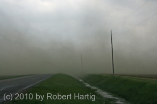
All of the above are reasons commonly given by chasers why they will never abandon their vehicles in favor of a ditch. I’ll add one of my own: Unless a ditch is sufficiently deep, chances are good that the wind will just scoop you right out of it and blow you away. Take a look at this photo of a rear-flank downdraft (a type of strong, straight-line wind from a severe thunderstorm) and note how the dust fills the shallow ditch on the right. The RFD jet was crossing the road about 100 feet in front of our car when I snapped the photo, and it was easy to see that the wind wasn’t merely blowing over the ditch–it was blowing into it. There’s no reason why tornado winds won’t do exactly the same thing, only a lot more intensely. (Note as well the rainwater in the ditch and the power lines hanging overhead.)

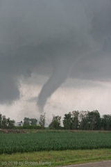
Still not convinced? Check out this up-close video of a small but intense tornado traveling along a roadside ditch in Minnesota and consider how you would have fared had you been taking shelter there.

And then there’s the obvious.

Why on earth would you want to abandon your best means of escaping the tornado altogether, not to mention the added protection your vehicle affords, in order to expose your soft, pink body fully to the elements?

Contrary to what you may believe, you can outmaneuver a tornado. Storm chasers do it all the time. Tornadoes move at roughly the same speed as their parent storm. True, some can rip along at 60 mph or more, particularly in the early spring. But most tornadoes move at a much slower rate, generally between 25-45 mph. Given a decent road grid, unless you’re in an an urban area where traffic is congested, or unless your view of the tornado is impeded by terrain or precipitation, your most commonsense survival tactic is to get out of harm’s way. If you can see a tornado, you should be able to escape it unless it is nearly on top of you.

How to outmaneuver a tornado: advice for the average Jane or Joe.

Those of you who are storm chasers can skip this section. You’re already quite familiar with approach and escape tactics, or at least, you should be. (Of course, you’re more than welcome to share your own wisdom in the comments section, and I hope you will.) The following is written for the saner 99.9 percent of the population who don’t go gallivanting across the vast American heartland in the hopes of encountering massive wind funnels filled with debris, but who would like to know what to do when they see one approaching while they’re out driving in their cars.

Let’s say you find yourself in just such a situation. Your most obvious first step is to determine whether the tornado is moving toward you. Chances are it will simply miss you. If you’re north of its path, you may want to park under a shelter, because if you’re not already getting clobbered by hail, you probably will be shortly. If you’re south of the tornado, you might want to head a little more south yet just to be on the safe side. Then pull of the road and enjoy the spectacle, because it’s not one you’ll see every day.

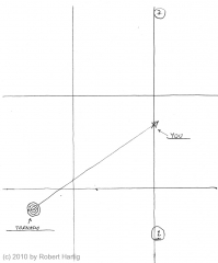
If the tornado is in fact heading your way–if it appears to be growing larger without apparently moving–then you need to take action. Assuming that it’s approaching from the west or southwest, as will be the case in most (though by no means all) situations, your best bet is to head south.

In the map to your right (click to enlarge), the tornado is moving northeast directly toward you. Note the location of the number 1. That’s the general direction you want to head in for reasons you can easily see. If south isn’t an immediate option, then drive east and bail south at your first opportunity. Depending on how near you are to the tornado as it passes north of you, you may get slammed with vicious straight-line winds wrapping in from the storm’s rear flank, but that’s better than getting munched by the tornado itself.

The overall point is to sidestep the tornado by moving at a right angle to its path. (Situation: You’re standing in the middle of a railroad track and a train is coming. What’s the smart thing to do? Answer: Right–step off the tracks!)

Heading north toward location 2 is also an option, but it’s one you’re better off avoiding if you can. While you’ll escape the tornado, you will very likely find yourself in the storm’s hail core. As a general rule, heading south will take you away from the big hail and blinding rain. Of course, if you think the tornado is likely to pass south of your location and you’re concerned about crossing its path, then use common sense and either stay where you are or else move north.  Better to risk losing your windshield than your life.

Let’s say, though, that you’re in a worst-case scenario. There’s no fleeing. Many chasers, probably most, would still prefer to ride out a tornado in their vehicle rather than in a ditch. Granted, neither option is a good one. There’s no question that the more violent tornadoes can do horrible things to an automobile; pictures abound of cars and trucks crumpled into balls of metal, or wrapped around trees, or filled with lethal debris. But at least your vehicle provides a layer of protection that you wouldn’t have in a ditch.

So is a ditch ever a good option?

This is a good place to mention that the ideas shared in this article are my opinion. They are not the result of scientific research. Then again, neither is the decades-old advice to abandon your vehicle for a ditch. It started as someone’s reasonable-sounding idea that gained authority through repetition rather than actual proof. Still, it does make sense to get as low as possible during a tornado, and I personally think there are occasions when a ditch could offer viable protection.

It’s a matter of situational awareness. Is the ditch deep, deep enough that it could minimize your exposure to the wind? If it were me, that would be my first question. Assuming that the answer was yes, my next concern would be with my surroundings. I would feel much more hopeful about sheltering in a ditch in the open countryside, with little in the way of trees and other large debris to get chucked at me, than I would in an area full of structures all strung together with power lines. And what about vehicles? I would certainly want to get far enough away from my own car that it wouldn’t be likely to roll over on top of me.

Flash flooding? Snakes? Those issues are of greater concern in some parts of the country than others. The best I can say is, know the environmental hazards of your territory and make your choices accordingly.

Again, the best way to survive a tornado is to get out of its path. Since most tornadoes are only a few hundred feet wide, avoiding them in a vehicle is quite easy given decent visibility, good roads, and ample lead time. If you’re in your car and you spot a tornado approaching in the distance, don’t take the fatalistic view that you can’t outrun it. It’s probably not heading directly at you in the first place. Determine where it is heading and do what you need to in order to position yourself elsewhere.

However, if it appears to be growing larger without moving to either the right or left, then you need to either skedaddle or else find adequate shelter. Ditches rarely qualify. In most circumstances, you should consider a ditch as only a last-ditch option.

Getting Set for a Backyard Chase

Last night’s bow echo certainly didn’t disappoint. I first spotted it in Wisconsin when it was a supercell putting down tornadoes near Milwaukee and thought, “That sucker is headed straight at us.” I watched as it hit Lake Michigan, maintaining rotation for a while but eventually morphing into a big bow echo. But what a bow echo! That northern book-end vortex really cranked as it moved inland and into the Kent County area. For a few scans of the radar, it looked like a small hurricane. Little wonder that it generated tornado warnings with a few reports of sightings by spotters and law enforcement.

But nasty a storm as it was, last night’s weather was probably just a prelude to what today, Wednesday, has in store. Veering surface winds taken into account, this could nevertheless be a tornado day for Michigan. The NAM shows a 70 knot 500 mb jet max blowing through the area, CAPE over 2,500, 70 degree dewpoints, and STPs to make a chaser happy.

Looks like it’ll be Kurt Hulst and me on this one. Bill is heading to Lansing to hang out with Ben Holcomb, and I think Mike Kovalchick is going to join them. That’s a good place to start. I’m not sure that I want to play quite so far east early in the game tomorrow, but I’m sure we’ll wind up well east of Lansing before the day is done. As of the 00Z run, it looks like the H5 will be nosing into West Michigan around 18Z, kissing an intensifying LLJ. Kurt and I had talked about setting up shop around I-96 and M-66. We’ll see what the 6Z run has to show us and play it from there.

At last, a Michigan chase with some real potential! And while I had guessed that storm motions would be in the neighborhood of 40 knots, the NAM decelerates them to a very manageable 25 knots. This could prove to be an interesting day, though I hope not a terribly impactful one. Southern Michigan has a lot of population centers, and I inevitably have mixed feelings whenever I see a big weather event shaping up for this area.

1965 Palm Sunday Tornadoes: Great Forecasting, Poor Warning Infrastructure

The death toll for the historic 1965 Palm Sunday Outbreak varies depending on your source, but the number 271 packs the authority of a U. S. Weather Bureau survey submitted by a five-man team to Dr. Robert White, the chief of the bureau, just three weeks after the disaster. Add to it one known casualty from Iowa who lingered until after the report was released before succumbing to his wounds, and 272 is a reasonable tally.

However many deaths were in fact attributable to the Palm Sunday Tornadoes, the bottom line is, a shocking number of people perished in the 20th century’s second-worst tornado outbreak.

Why? Certainly there was no fault with the forecasting, which was as spot-on as you could possibly hope for, even without the benefit of all the severe weather parameters that exist today.

The research team appointed by Chief White asked that same question: what was the breakdown? Three weeks after conducting extensive surveys through the tornado-stricken six-state region, they had answers, and recommendations to accompany them that have shaped the course of both tornado research and operational forecasting.

The Weather Bureau Survey Team Report of Palm Sunday Tornadoes of 1965 is fascinating in a number of respects, not the least being the fact that in it, one can see the shape of things to come. Striking as well, amid the overall commendable efforts on the part of the various weather bureaus to warn the public, were a few notable communication disconnects. The report shows that the first two tornadoes of the outbreak struck at about the same time, 12:45 CST, in eastern Iowa. The first warning wasn’t issued until 1:00, fifteen minutes later.

In West Michigan, the Alpine Avenue F4 tornado in northwest Grand Rapids, which leveled the Swan Inn and tracked as far as Rockford, struck at the same time that the first warning was issued. Ditto for the town of Burnips, located fifteen miles southwest of Grand Rapids. Residents in the beginning paths of these tornadoes had zero lead time. Two hours later to the east, in similar fashion, Radnor, Ohio, received its warning at the same time that a tornado was tearing its way through town. As for Marion, Indiana, seven minutes advance notice was probably very little better than nothing.

Remember, in those days, civil defense sirens weren’t sounded during tornado warnings in Great Lakes communities. The only means of alerting the public to imminent danger was radio and TV, and those depended, of course, on people being tuned in to them.

The long and short of it is, the warning system back then was nothing like what we have today. We’ve come a tremendously long way in 45 years. Many of the strides we’ve taken were first set in motion by the research and recommendations of the Palm Sunday Outbreak survey team. If anything good can be said about the mayhem of that dark April evening, it is that out of its tragic losses arose advances in the public warning system that continue to do a marvelously effective job of saving lives today.