Hurricane Irene demonstrated to me conclusively that hurricanes aren’t my thing. Maybe I’m too cautious; maybe I’m downright chicken; maybe I’m smart. Certainly I’m inexperienced; just as certainly, I’ve never felt the same fascination for the hurricane environment, as I’ve understood it, as I have for tornadoes and supercells. However these various factors work in combination, the bottom line is, while I’m glad I got the opportunity last weekend to experience an impressive degree of Irene, if not her full fury, I doubt that my future holds any more hurricane interceptions.
Hurricanes and tornadoes are different animals, and the mindsets required for a severe weather junkie to appreciate the two are worlds apart. A tornado is ephemeral, arriving and departing in minutes; a hurricane is a time commitment of hours, possibly a lot of hours. A tornado is something you go to see; a hurricane is something you go to experience. A tornado’s human impact is terrestrial; a hurricane’s, amphibious, bringing the ocean with it as it arrives onshore. A tornado is something you seek to avoid getting munched by; a hurricane is something you purposely allow to ingest you, and it requires that you be willing to risk circumstances of a kind and scope that can outstrip anything even the worst tornado can produce.
I’m by no means minimizing the lethal, wholesale destructiveness of tornadoes. I’m just saying, we’re comparing apples and oranges. Yes, both storms pack a heckuva lotta wind, both are capable of horrific impact on communities, and both can kill you equally dead. But beyond that, the similarities vanish.
Different personalities embrace the variables in different ways. My friend and long-time storm chasing partner, Bill Oosterbaan, is now hooked on hurricanes. His brother, Tom, enjoyed doing the eyewall with Bill at Morehead City, North Carolina, but I suspect that once was enough for him. As for me, witnessing the massive surf pounding Atlantic Beach as Irene approached, and watching tropical-storm winds and hurricane-force gusts blast our hotel inland at Greenville, was all the taste of Irene I needed. Don’t get me wrong–the experience was thoroughly exhilarating, and I’m really glad I went. I just can’t see doing it again, particularly with a stronger hurricane than Irene.
I never expected to go to begin with. As Bill and Tom were making plans a few days in advance, I chimed in on the discussion, but I had neither the money nor the driving desire to join them, though I confess that I was intrigued. Then Bill called me three hours before their departure with the news that their trip would be underwritten and wouldn’t cost a cent. Would I like to go?
It was a kind, thoughtful offer. Bill knew that this storm season–historic and record-breaking as it has been for tornadoes–had been a miserable one for me as far as chasing went. Between family responsibilities and personal finances, it had been an utter washout, to the point where I’ve felt awkward even calling myself a storm chaser. Yeah, I’ve earned the merit badge over the last 15 years, but you wouldn’t know it judging by this year. Bill and Tom, good friends that they are, knew that I had felt the disappointment keenly and wanted me to have at least something to show for circum 2011.
So, making a last-minute decision, I grabbed the opportunity, threw some clothes into my softside, grabbed my gear, and off we went.
GPS and Live-Stream Hassles
Bill had made arrangements with WOOD TV8 to live-stream Irene using his new, super-fast Asus quad-core laptop. Unfortunately, DeLorme’s serial port emulator wouldn’t work with the laptop’s 64-bit Windows 7 OS, nor would Bill’s GPSGate recognize the DeLorme puck. The long and short of it was, while Bill could stream through iMap, there was no way of showing his location, rendering his live stream useless.
My computer isn’t as fast as Bill’s, but it’s fast enough, and it didn’t pose the same problems. However, for some reason, I kept losing my mobile signal Friday as we headed towards Morehead City. Worse yet, my output on iMap appeared jerky and horribly pixelated, to the point where I finally just gave it up. So much for live streaming for both of us. And so much for getting the trip underwritten.
Big Surf at Atlantic Beach
Friday, August 26. After checking into our hotel in Greenville, North Carolina, we set off for Morehead City. When we arrived, the bridge to Atlantic Beach beckoned, so over we went. We parked in a lot occupied by various media crews as well as casual sightseers. With just two hours before law enforcement intended to start kicking people off the island, we bundled on our rain gear and took in the massive waves pounding the shoreline.
The eye of the hurricane was still a good 150 or more miles south of us, but the wind was stiff and the sea a maelstrom of spuming breakers and brown, roiling undertow. My YouTube video doesn’t do justice to that wild, watery scene. The waves farther out in the video had to have been a good 15 feet high, their tops trailing spray into the gale as they raced toward shore.
By the way, that’s me in the rain jacket and shorts, cavorting in front of the waves. Hi, Mom!
Bill was determined to stick around and experience the eyewall, and I had the nervous sense that he wanted to hang out on the barrier island. My concern was that the island might wind up underwater, and that even Morehead City could get inundated by floodwaters, or the storm surge, or both. It just didn’t seem wise to me to locate ourselves that close to the Atlantic shoreline. Irene, which the day before had been forecast to make landfall as a category 3 storm, had by now been downgraded to a top-end category 1, but she was still an abnormally huge hurricane. I was concerned that our escape routes would be cut off and we would find ourselves stranded, with nowhere to go and the ocean encroaching on us as Irene’s eye moved in. High winds I’m fine with–bring ’em on; I like it. But I prefer them as a dry-land phenomenon, not a maritime experience.
Ultimately, I wimped out. The guys graciously brought me back to our hotel in Greenville, which was where I’d thought we would ride out the storm to begin with. I felt ashamed of myself for inconveniencing them, and I knew that Bill was disappointed. We’ve shared so many storm adventures over the years, but this wouldn’t be one of them. To be fair to myself, my reasonings–not all of which I’ve elaborated on here–were, I believe, fairly sound. Plus, again, I’ve never felt drawn to hurricanes the way I am to tornadoes and severe thunderstorms. Still, I had moved from an asset to a liability.
I beat myself up for quite awhile, so in case anyone reading this post feels inclined to pitch in their two cents, spare yourself the effort. I already did the job for you. That said, there was something to be said for peeling off my sopping clothes–which, thanks to a catastrophic failure on the part of my Helly Hansen rain suit, had gotten totally drenched–and then kicking back on a dry bed to watch the unfolding coverage of Irene on TV.
Saturday, August 27
When I awoke, Irene was making landfall at Morehead City. I picked up the phone and called Bill. No answer, and no surprise. I wasn’t certain whether the cell phone towers were working, but I was sure that the guys had their hands full. The television showed the west side of Irene’s eye squarely over their heads.
Outside, the wind was lashing a tree out in the courtyard and blowing a fine spray of rain against the window. Hurricane rain is not like the rain you get with an ordinary thunderstorm. The hydrometeors are smaller, halfway between droplets and wind-driven drizzle. But what a drizzle! Watching the stuff lash horizontally across the landscape, alternating between lighter respites and sudden, heavier bursts that tumble along like fog shot from a cannon, you really can’t fathom just how much is actually falling. The answer is, lots, an almost inconceivable amount.
By and by, I got curious what the view offered from a vantage point other than my fourth-floor room. Grabbing my video camera, I took the elevator downstairs and headed for the hotel entrance. There, for the first time, I got a good taste of Irene. Greenville may not have been in range of the hurricane’s full force, but the westward extent of her tropical-storm winds had surprised forecasters, and my location lay within a concentrated area of those winds. With sustained speeds of 55 mph and gusts as high as 75 mph, there was more than enough to hold my interest.
The higher winds in a hurricane are associated with its rain bands. When you see one of those bands approaching your location on radar, you can count on two things happening simultaneously: It is going to get very rainy, and it is going to get very windy. The transition occurs with a suddenness that verges on explosive, and in Greenville, its effect was everything you could imagine. Trees were down, and more were going down all the time. Branches were snapping. Power was out over a large area. In the hotel, the electricity flickered off and on, off and on, but amazingly, it somehow stayed with us for all but one two-hour stretch. As for Internet connection, forget it. I had been without radar updates since shortly after 8:00 a.m. So much for getting GR2AE volume scans of Irene while she was over Morehead City. They’d have made a nice memento for the guys, but there was no accessing the data.
The Storm Troopers Return
Bill and Tom returned around 3:00 in the afternoon, exhilarated and exhausted. After showering up, they headed back out into the wind and rain to catch dinner at one of the few open restaurants. They returned in an hour and filled me in on their eyewall experience. It sounded awesome, and I’m glad it was everything they’d hoped for. I can honestly say I didn’t mind having missed it, but I was pleased that they got what they were after. Particularly Bill. Experiencing a hurricane is something he’d been wanting to do for several years, and now that he’s gotten it in his blood, I’m quite sure he’ll do it again.
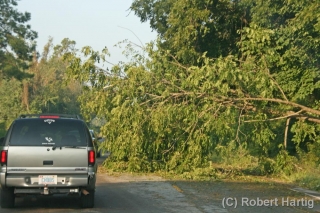
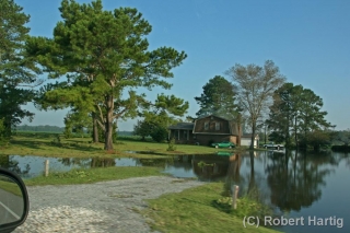
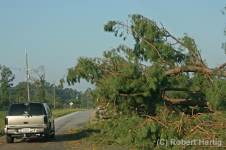
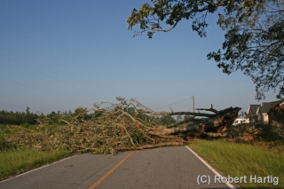
We started for home around 8:00 Sunday morning. The first 25 to 30 miles westward were littered with downed trees. Some of them blocked the road, requiring us twice to find an alternate route. In a few places, yards and even homes were flooded. Corn fields had been flattened by the wind and rain, and the tobacco, while not appearing as badly ravaged, had clearly taken a hit. Other more compact crops such as cotton and soy beans had fared better.
Fourteen hours later, a few minutes after 10:00 p.m., we rolled into Bill’s driveway, and a short while afterward, I was in my own vehicle driving east down M-6 toward home and my sweetheart, Lisa.
Will I do another hurricane? Well, I didn’t entirely do Irene for reasons I’ve at least partly explained. I did, however, get enough of a taste to confirm my sense that hurricanes don’t exert the same pull on me as tornadoes. I’m grateful to Bill and Tom for wanting me to join them–thank you so much, guys! I really appreciate it. Those middle rain bands in Greenville may not have been as intense as what you witnessed, but they were a blast, and I’m very glad I got to see at least that much of Irene.
However, lacking the passion required for accepting the risks involved, I would likely be just as reluctant to commit to a landfall intercept in the future as I was this time, and thus I would simply detract from the experience for others. That wouldn’t be fair to them or enjoyable for me.
So, while the old saying may be, “Never say never,” I seriously doubt that another hurricane lies on my horizon. Not anytime soon, anyway. If you enjoy multiplied hours of wind, water, sweat, and uncertainty, then a hurricane just might be your thing. Me, I’ll stick with tornadoes. They’re not so all-fired comprehensive.
