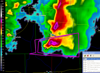
Michigan’s first supercell of the year rolled through southern Michigan this morning, prompting our state’s first tornado warning for 2010. The cell was a sweet little tail-end Charlie that showed bursts of decent rotation and triggered a series of TVSs. It is presently getting set to exit the state near Mount Clemens, leaving behind it a series of hail reports up to an inch but nothing more. It’s what one would expect given the cool temperatures, low dewpoints, and weak-to-borderline low-level helicity.
Here’s a GR3 radar grab of the storm as it was crossing US 127 south of Mason; click on it to enlarge it. A scan or two prior the cell had a nice hook to it, and you can still see the suggestion of a weak echo region with inflow coming in from the east.
Caledonia got nailed by the northern part of the line earlier. At 10:20 a.m., the sky was as dark as a black cat’s belly and the parking lot lights were on. There were one-inch hail reports in the area; my friend Kurt Hulst called to tell me that he had gotten marbles over at his apartment and wondered whether any of that had come my way. It hadn’t, but we got a truly massive downpour, really something to see. It’s going to bring a lot of green to an already nicely greening landscape.
More storms in the forecast for today. Yeah! Bring ’em on!


