Last night’s tornado in Yazoo City, Mississippi, thankfully appears to have been not nearly as bad as its monstrous EF-4 predecessor back in April, but it was bad enough. It was one in a round of tornadoes that trampled across the South yesterday afternoon on into the night. Fed by ample moisture and energized by bulk shear exceeding 60 kts and 1km helicity exceeding 300, supercells had no problem firing up and dropping tornadoes. At the time of this post, seven tornado reports have been logged for Dixie Alley–one in Louisiana and six in Mississippi. (A tornado was also reported in northwest Missouri, but that’s far removed from the southern storms and was a separate situation.)
I watched my GR2AE radar screen in disbelief last night, shortly before 9 p.m. EST, as strong circulation progressed from the southwest toward Yazoo City. “No way,” I thought. “No freeking way.” How could the same small town get clobbered by a tornado twice in the same year? It wasn’t going to happen. It just couldn’t. But it did.
At 8:18 CST a tornado warning was issued–a continuation of a previous warning–which contained the following statement: AT 816 PM CST…LOCAL LAW ENFORCEMENT REPORTED DAMAGE FROM A TORNADO JUST PASSING THROUGH THE CITY. THIS TORNADO WAS LOCATED 6 MILES SOUTH OF EDEN MOVING NORTHEAST AT 50 MPH. At that point I could see the potent SRV couplet moving right through what appeared to be the south edge of the town. According to reports this tornado crossed the path of the April storm, like a letter X. Fortunately, it appears to have been nowhere nearly as large or violent, and a scan or two later showed the mesocyclone weakening considerably as it left the city. Here is the string of reports from the National Weather Service at Jackson:
0800 PM     TORNADO          5 SW YAZOO CITY         32.81N 90.47W
11/29/2010                   YAZOO              MS   AMATEUR RADIO

            3-4 MILE LONG PATH OF DAMAGE ALONG EAGLE BEND ROAD.
            LIKELY TORNADO DAMAGE. UPDATED...VEHICLE
            OVERTURNED...STRUCTURAL DAMAGE...SHOP DESTROYED. NEAR THE
            NORTHERN INTERSECTION OF EAGLE BEND ROAD AND HWY 3.

0808 PM     TORNADO          YAZOO CITY              32.86N 90.41W
11/29/2010                   YAZOO              MS   AMATEUR RADIO

            DAMAGE TO THE COURTHOUSE ROOF IN DOWNTOWN AND A LARGE
            TREE DOWN NEXT TO THE COURTHOUSE. WIDESPREAD DEBRIS IN
            THE AREA.

0810 PM     TORNADO          YAZOO CITY              32.86N 90.41W
11/29/2010                   YAZOO              MS   AMATEUR RADIO

            ADDITIONAL STRUCURAL DAMAGE REPORTED IN YAZOO CITY WITH
            NUMEROUS LARGE OAK TREES SNAPPED AND UPROOTED. POWER
            LINES ALSO REPORTED DOWN ALONG CENTER RIDGE ROAD.

0810 PM     TORNADO          YAZOO CITY              32.86N 90.41W
11/29/2010                   YAZOO              MS   EMERGENCY MNGR

            MAJOR STRUCTURAL DAMAGE REPORTED TO AT LEAST 18
            BUSINESSES...MINOR DAMAGE TO AT LEAST 3 WOODEN FRAME
            HOUSES. ENTIRE FACADE OF ONE DOWTWON BUILDING HAD ALL
            WINDOWS BLOWN OUT. 30 PERCENT OF YAZOO CITY REMAINS
            WITHOUT POWER.

0810 PM     TORNADO          YAZOO CITY              32.86N 90.41W
11/29/2010                   YAZOO              MS   AMATEUR RADIO

            POWER LINES...TREES...AND WIDESPREAD POWER OUTAGES ARE
            REPORTED WITHIN YAZOO CITY. WILL UPDATE FURTHER WITH
            ADDITIONAL INFORMATION.
.
While Yazoo City stands out by virtue of having gotten hit twice this year, other communities also sustained damage. The show began in the afternoon and evidently continued through the night, because when I woke up this morning and fired up my computer, I saw a tornado warning in Alabama. Tornado watches are currently in effect for the southeast, and the SPC shows a slight risk extending north as far as southeastern Pennsylvania, with a 10 percent hatched area reaching from South Carolina into Virginia.
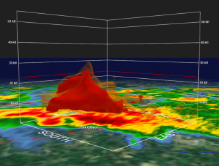
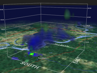
The images on this page are GR2AE volume scans of the next supercell southwest of the Yazoo City storm, heading on a trajectory just west and north of Port Gibson. Click on the images to enlarge them. The time was 0232Z, or just a couple minutes after 8:30 CST. The topmost frame shows a hook and correlated structure above it, with the suggestion of a pretty healthy BWER. The bottom frame depicts vigorous rotation.


