An Interview with Shane Adams, Part 1: Retrospectives and Perspectives on Storm Chasing Yesterday and Today

In recent years, due largely to the influence of Discovery Channel’s Storm Chasers series, storm chasing has exploded as an avocation. What began over fifty years ago with a handful of individuals roaming the American heartland in pursuit of nature’s most violent and beautiful storms has evolved into a hobby practiced by multitudes, shaped by the media, and facilitated by state-of-the-art technology.

Today, equipped with a laptop, a modem stick, and radar software, a beginning chaser has an excellent chance of seeing tornadoes right out of the starting gate. But it wasn’t always so. Once there was no GR3, no mobile data, no live streaming, not even any laptops—and nowhere nearly as many chasers as there are today.

New chasers conceive of storm chasing as it is, not as it was. That’s inevitable. People live in the present, not the past, and any of us can only board the train from the platform we’re standing on. Yet the past wasn’t all that long ago—that pre-tech era when the tools of the trade were few and the likelihood of busting far greater. Those of us who came up during those simpler times treasure the experience and carry a different perspective than those who cut their teeth on techno-chasing.

To scores of chasers who have been around the block a few times, Shane Adams needs no introduction. Shane has been a storm chaser since 1996. He’s well-known as a passionate and highly experienced chaser who lives, eats, and breathes storm chasing. With six storm chasing videos to his credit, Shane is the host of the weekly podcast The Debris Show; and, with his girlfriend and fellow chaser, Bridget Geaughan, he is the coauthor of the storm chasing blog Passion Twist.

Shane was good enough to do a written interview with me covering a broad range of topics of particular interest to storm chasers. The questions and responses range from the retrospective and occasionally philosophical to the practical.

Shane is an articulate, thoughtful, and passionate interviewee with much to share. Since the article is lengthy, I’ve broken it into two parts. In this first part, Shane talks about his personal development as a storm chaser; and, in the light of his own experiences, he reflects on the state of chasing today.

In part two, which I’ll release in another day or two, Shane talks about his personal approach to forecasting and chasing. He shares his unique account of chasing the tragic May 4, 2007, Greensburg, Kansas, supercell, and he looks back on the three most outstanding chases of his career.

Enough of my introduction. Here’s part one.

.

Interview with Storm Chaser Shane Adams

.

Question: Some background stuff to begin with. Talk a bit about your boyhood. You currently live in the Fort Worth, Texas, area. Have you lived in Tornado Alley all your life?

Shane: I was born in Oklahoma City and lived there until my parents divorced at age four. After the divorce, my mother and I moved to Healdton, Oklahoma, which is in the southern portion of the state. Growing up there for me was fun, because we lived in the same house for thirteen years, and I made many lasting friendships and knew the area well. We had a pasture that butted up to our neighborhood, and my friends and I would spend countless hours playing out there, back when kids actually played outside. That was pretty much my life pre-storms, although growing up in Oklahoma my entire life, I had been aware of storms as far back as I could remember.

Q: What event, or events, first served to flip the switch of your fascination with tornadoes?

S: As I mentioned, I had always known about thunderstorms. I can remember way back, first seeing this weird word they always used on television weather warnings: tornado. I knew about severe thunderstorms but had no clue what a tornado was. My mother tried to explain it to me, but her very limited knowledge and understanding, coupled with my young mind, just didn’t really paint the picture.

Then April 10, 1979, came along. A massive F4 tornado ripped through southern portions of Wichita Falls, Texas, just eighty miles southwest of Healdton. A few months later, one of the local television stations did a story on the tornado. I was in my room when suddenly my mother started yelling for me. I ran out into the living room, and she pointed to the television. I looked at the screen and saw a huge, black, boiling mass of cloud scraping along the ground below the most ominous sky I’d ever seen. “There,” she said. “That’s a tornado.”

I was hooked for life.

Q: It’s one thing to be intrigued by tornadoes; it’s another to actually chase them. When did you first start chasing, and what inspired you to do so? What was your first chase like for you?

S: I dabbled with chasing for years before I really started, but this was nothing more than glorified spotting. I would move from one edge of town to the other, but when the storms moved on, I never followed. I did this infrequently from 1988–1995.

On April 21, 1996, I went on my first true chase, where I actually drove out of town, over the road, to try and find a tornado. However, this too was a spur-of-the-moment thing, and I only had a cheap disposable camera and a cooler full of ice in case I found big hail. There was no plan, except that if I got into hail bigger than golfballs, I would back off, fearing a tornado I couldn’t see would be close behind.

I did get hail up to golfballs that day, saved a few in my cooler, and took a few snapshots I never developed. But this was nothing I would consider a real chase by my standards. To make it a real chase for me, there must be a video camera for documentation. Otherwise, it’s just a drive.

My first “official” chase was June 6, 1996. I was working a landscaping job with a friend of mine named Greg Clark. It started to get stormy early that afternoon, so we decided to knock off early. I said on a whim, “We should go chase these storms and try to find a tornado.” Greg not only liked the idea but suggested that we grab his mother’s video camera and tape the experience. It had never crossed my mind to actually videotape a tornado, but I was wild about the idea. (As it turned out, having the video camera that day was pivotal towards me becoming a chaser).

We grabbed the video camera, stopped by my place to look at a live update from one of the local television stations, and then took off towards a storm that was tornado-warned. There was no plan; we just called it as we went. All I knew at the time was, you want to be out of the rain, so we just drove right into the heart of the storm until the rain stopped. A lowering was to our south, so we turned east to pace it. We stopped, and I started shooting video. Literally seconds after I did, a small tornado formed out of nowhere, right in the spot I was pointing at, lasting less than a minute. It was pure dumb luck, but it was a critical moment for my chasing future.

Q: That first tornado obviously hooked you. What was your growth curve as a storm chaser like from that point?

S: I laughed out loud when I read this one. To put it simply, I was horrible. For years. I got by the first four or five years on sheer passion and tenacity. I didn’t know anything about the atmosphere or that I even needed to. Computer models were something I didn’t even know existed for the first year I chased. All I was armed with was an unrelenting, unrivaled passion to see tornadoes. There really was nothing else other than the minimal, basic structural and behavioral experiences I was slowly developing as I chased more and saw more.

As the years started going by, I started to recognize patterns and tendencies purely from what storms looked like or what the sky in general looked like. By my fifth season, I was pretty good at working a storm—meaning, how I handled it once I found it—even though I knew virtually nothing about finding storms. Basically, I learned how to chase storms way before I ever learned how to forecast them.

Q: Who were some of your key influences during those early years—people who helped you learn the ropes or who simply inspired you?

S: The first storm chaser I ever heard of was Warren Faidley. I received The Weather Channel’s Enemy Wind on VHS for Christmas in 1992 and wore the thing out. I had no clue there were people out there who actually chased storms seriously. But even more, I had no idea there were several people other than Faidley who had been doing it for years.

The first storm chaser I began to seriously follow and look up to was Jim Leonard. He was bigger than life to me. I was brand-new to chasing and just discovering the wonders of my storm chasing passion. Jim was the guy who, in my eyes, had done everything I wanted to do. His dedication to the art of chasing, and the fact that he’d started around the same age as I was and was still as dedicated well into his forties, was amazing to me. I idolized him, and I’m not the star-struck type. I met him briefly at a landspout seminar hosted by Al Pietrycha in Norman in 1997. I asked him a few questions about what was, at the time, my favorite intercept video from him: his June 8, 1995, Allison, Texas, wedge tornado. It was such a thrill to actually be standing next to my hero, although he had no clue who I was or that I worshiped him LOL.

Another chaser who, in my later formative years, really reached out to me was Gene Moore. He realized how ignorant I was but also saw my passion and dedication. While he could’ve easily ridiculed me, he instead took the time to talk to me about a few things he considered the basic, important essentials for storm forecasting. Things I still use to this day, every forecast, every chase.

Q: You came up in a time when technology and the media hadn’t yet shaped storm chasing the way they do today. What was chasing like for you in those days? What benefits do you think you gained from the minimalist, old-school approach that younger chasers today are missing?

S: The main difference between chasing now and chasing when I started is the laptop computer, but that’s over-simplfying things. Back in the day, we didn’t just not have computers, we didn’t have smart phones or iPods either. Today’s chasers never have to deal with long hours on the road the way chasers did years ago. Sure, twelve hours cooped up in a vehicle is still extreme, but it definitely softens the experience when you have constant entertainment at your fingertips, the way you would at home.

Chasers today don’t talk to each other, they chat. They stream. They surf. They listen to music. There will be a carload of chasers and each one will be in their own world, playing on a cell phone. Chasers today will never know what it’s like to spend twelve hours in a car when all you have for passing the time is conversation. And many times for me personally, I didn’t even have that, because many of my past partners were champion sleepers when there was nothing exciting going on. It takes a special kind of person to willfully strap themselves in for a ride that could last over twenty-four hours, with absolutely no guarantee of seeing anything—even less of a guarantee without constant streaming data 24/7 to lead you to the storm on a string—and absolutely nothing to pass the time. These techno-generation chasers will never experience that level of dedication, and quite frankly, if many of them were to, I doubt some would stayas dedicated.

Basically now, chasing is just people doing all the same things they would be doing at home otherwise, except there’s a drive involved and maybe a storm or tornado. The “grueling, long hours” which are so often brought up by chasers praising their allegiance to their craft are nothing more than what they do every day, except they have to stop to use the potty.

I’m very grateful I was able to endure the type of chasing I did for a good number of years. We would jump in a car and drive to Missouri or Illinois from Oklahoma on a whim, with nothing to guide us except NOAA radio. We were always broke, so hotels were an extremely rare treat at best, maybe once or twice a year. Normally we’d just drive in shifts, and do straight-through chases of twenty-four hours or more. And this was with no Internet, no Spotify, and no Angry Birds. Just a carload of guys who shared one common goal: to see a tornado.

One time in 2000, we left Norman at 1:00 a.m. and drove straight through to North Dakota only to miss all the tornadoes by forty-five minutes. We stayed the night in Fargo, then drove straight back the next day, missing even more tornadoes because we got there too late again. That was a 2000-mile, two-day trip for some thunder and lightning. We had several of those back in the day, when the only thing fueling us was the desire to simply see and videotape a tornado.

There are few of today’s new chasers who would ever willfully endure that type of experience. Kids today want everything on a plate, with a remote, a keystroke, or some other too-easy device designed for no other purpose than to make an already easy life that much easier. A lot of chasers like to toot their own horn (nice pun, eh?) about how dedicated, extreme, and hardcore they are. Doesn’t take much to drive 500 miles when you know you’ve got Internet the entire way and a nice, comfy hotel bed waiting for you that night. Try it with nothing but a NOAA radio and knowing that regardless of what happens, you’re not sleeping again until you get back home the following day. That’s hardcore.

But it’s a different world, and I have to accept that. I look around, and I really can’t relate to most newer chasers. They rely on electronics for their lifeblood, they care as much about making money as simply videotaping a tornado, and they’re all so busy trying to come up with the next big thing or gimmick. For me, at the end of the day, it’s about the storms and tornadoes, period. Streaming doesn’t matter, money doesn’t matter, and every other chaser out there doesn’t matter. All that matters is my video camera and that tornado in front of it. My day ends when the last tornado ends and the setting sun bleeds away. Their day is just beginning, hustling to contact brokers or potential customers with their day’s bounty. That’s fine for them, but chasing isn’t work for me. It can’t be, because I love it too much to ruin it by putting money at the top of the priority list. Everyone likes to deliver that famous line, “Hey, if I can get some money back that’s great,” but the reality is, once you taste money from chasing, it stops being about seeing storms and starts being about selling video. Because making $$$ from chasing is too much work for it not to be the top priority.

I’m happy fading back into obscurity, with my long resume filled with amazing catches the world doesn’t value because they haven’t been splashed all over the internet and television. I’m perfectly content to sit back and watch the flame wars, the ego battles, and of course, the constant brand/money wars. I watch this blur of an activity, as it is today, and smile inside, thinking back to how simple and innocent it was so many years ago. Even more simple and innocent years before my own career started. I’m proud to have come along when I did, to get a taste of the tail-end of a great era of storm chasing. There’s no doubt I’m the chaser I am now because of the way I learned, and that’s something I cherish. I haven’t seen the most or the best, been the closest, or lived through the worst, been the most famous or the most respected. I’m just doing my own thing the best way I know how, and will continue to trudge forward, ever-attempting to pen the next chapter in my life’s storm chasing adventure.

(Coming in Part Two: personal forecasting and chase approaches, the 2007 Greensburg storm, and top three career chases.)
What Do You Need to Chase Storms?

“How do I become a storm chaser?” If you’ve been asking that question, this post is for you. I write it with some reservation, knowing that there are people more qualified than I to address the topic. That being said, I’ve been chasing storms with some modicum of success long enough now that I’m confident my insights can have value for those who wonder what it takes to get started.

What do you need in order to chase storms? I’ve seen some lengthy lists developed in response to that question. The input is good, but it can overcomplicate matters, and too much of it all at once can be daunting. If you focus on the word “need,” the answer is much simpler. That’s my approach here: strip it down to the basics, then build from there.

The Foundational Stuff

Here, in my opinion, are the few things that a storm chaser cannot do without:

◊ A roadworthy vehicle, be it yours or a chase partner’s. By “roadworthy,” I mean one that can successfully manage the terrain you’ll be chasing in. If your territory is the flatlands of Illinois and Indiana, or if you intend to stay on main roads that aren’t likely to run out of pavement, then pretty much any vehicle will serve you. On the other hand, if you plan to chase down west Kansas backroads, then you’d better have four wheel drive and great tires; otherwise, the clay out there will slurp you down and ruin your day.

◊ Road maps. Self-explanatory, I think.

◊ Money. You need gas for the tank, right? And maybe a burger along the way.

◊ Basic knowledge of storm structure. Sure, you can chase storms without knowing anything about their features and behavior. But you can’t chase them safely, and the odds of your chasing them successfully are slim. So learn all you can. West Texas storm chaser Jason Boggs has created an outstanding list of educational resources that you can access as quickly as you can click your mouse. Jason’s list mixes basic and advanced material together without discriminating between them. It’s all good, but you should start with the fundamental stuff that deals with storm structure. Veteran chaser Gene Moore’s material on identifying storm features is a good first bet.

Also, a quick plug for Stormtrack, the online informational clearing house, learning resource, and virtual community for storm chasers worldwide. You’ll learn an awful lot just browsing the forum.

One final word on learning: there’s nothing like a mentor. If you can hook up with a seasoned chaser who’s willing to show you the ropes, grab the chance. You can shorten your learning curve significantly. But if such a person isn’t available to you, don’t let that stop you.

◊ Light bars for your vehicle. Absolutely mandatory. How is the world going to know you’re a storm chaser if your vehicle doesn’t resemble a mobile road block?

JUST KIDDING! Don’t worry about light bars just yet.

That’s it for the essentials. Pretty basic, aren’t they–just you, your vehicle, maps, money, and a bit of knowledge. It really doesn’t take any more than that to intercept storms. The main thing is to get out there and do it.

Assuming that you’ve got the fundamentals in place, let’s look next at a few things that will make your chases more successful and your experiences more rewarding.

Important Tools of the Trade

Can you chase storms without a laptop equipped with radar software and mobile data? Of course you can! Ask any chaser who’s been around ten years or longer and they’ll tell you. When the pioneer chasers began paving the way for the rest of us, they did it without all the trimmings. Even Rain-X wasn’t trademarked until 1972, and David Hoadley was chasing storms long before then.

For that matter, I didn’t have any of the following tools of the trade for many years during my own illustrious ascent as a storm chaser. Of course, I didn’t see any tornadoes, either, so don’t take your cues from me. I will tell you that I had a lot of fun learning the slow, hard way. However, my successes came when I started adding a few resources, concurrent with improving my knowledge of forecasting and storm morphology.

All that to say that while the items below aren’t absolutely indispensable, that doesn’t mean they’re not important. They’re very important, and not many chasers today, including the veterans, chase without them.

◊ Laptop computer. It’s your control center.

◊ Power inverter to power your laptop and charge your cameras.

◊ Radar software. Besides a laptop, this should be your first purchase on the list of storm chasing tools. I recommend GR3, at least to begin with. It’s the one used by most chasers, and for good reason: it’s a fabulous program designed specifically for storm chasing, with incredible functionality and flexibility. Just get it, okay? For $80, trust me, you can’t go wrong. For that matter, you get a free trial period that lets you play with the program for a few weeks before you slap down your money.

◊ USB modem and mobile Internet connection. Your best bet is to purchase a USB modem outright; that way you’re not locked into a 2-year contract, and you can deactivate your account during the off-season instead of continuing to pay for data you’re not using. As for Internet connection, Verizon currently provides the best data coverage nationwide, and a lot of chasers use it. Others prefer Sprint, also a good choice. Where you’ll be chasing is something to consider in making your decision.

◊ Radar data feed for GR3. You can use the free feed that NOAA provides. But a lot of chasers prefer a dedicated feed such as those provided by Allisonhouse and MichiganWxSystem. Priced around $10 a month, such a feed is well worth the money.

Nowadays more chasers are using Android phones with radar apps. Not being the geeky type, and also not having the cash, I haven’t looked into these setups. I like having a large display in front of me anyway instead of a tiny screen, but I’m not knocking those who are working with with handheld units. The point is, however you get it and however you display it, you want good, detailed radar information delivered to you with timely updates.

◊ GPS and mapping software such as De Lorme. You’ll also want a serial port emulator that will allow you to use GPS simultaneously with both your map and your radar.

◊ Rain-X. Worth every dollar it costs, and it doesn’t cost much.

SPC Convective Outlooks link. After all, all your great gear doesn’t amount to squat if you can’t find storms! Since you’re new to storm chasing, chances are you don’t have the knowledge to make your own forecasts. Start acquiring it now, beginning with the Storm Prediction Center’s convective outlooks page. It will do two things for you: 1) show you graphically whether and where storms are expected to fire, and 2) through its detailed forecast discussions, familiarize you with the terminology and thinking that go into severe weather forecasting.

◊ Light bars. Don’t leave home without them. How will drab, ordinary, non-storm-chasing mortals know you’re a storm chaser unless…oh, hey, wait a minute. Sorry, we’re still jumping the gun. Forget I mentioned light bars. You don’t need light bars. Not now, anyway. Patience, patience!

Moving On

◊ Station obs, upper air maps, and other forecasting data. Here’s where it gets fun! Making your own forecasts is what separates the be’s from the wannabe’s, and sooner or later you’ll want to try your hand at it. Luckily for you, a cornucopia of forecasting resources is available to you for free online. So start acquainting yourself with the tools of the trade. Check out the tabs at the top of my Storm Chasing page for starters. Also, take a peek at the resources available on my friend Kurt Hulst’s site, Midwest Chasers.

◊ Anemometers, weather meters, and other gadgets. Once you start chasing, you’ll soon run into vehicles tricked out with various devices useful for personal monitoring of wind speed, wind direction, moisture, barometric pressure, and other localized weather conditions. You don’t need any of this stuff in order to enjoy success chasing storms. But depending on how deep and techy you want to get, you might decide that some of it is for you. Just get it for the right reason: to enhance your chasing, not to impress the world with a mess of whizbangs and dingdongs ornamenting the top of your vehicle.

Me, I like to keep things simple. Nothing about my car shouts “storm chaser,” and the only gadget I use is a Kestrel 4500 hand-held weather meter. It’s a cool little device, a regular Swiss Army Knife filled with all sorts of nifty features that I don’t need. I use it mainly to get local, real-time reads on the dewpoint, temperature, and wind speed, information that I do find very useful.

◊ Camera and/or camcorder. A no-brainer if you want to capture visual images of your chases.

◊ Communication equipment. While it probably goes without saying, you should at least carry a cell phone with you. A lot of chasers are also HAM radio operators, and this spring I’ll be joining their ranks with a hand-held unit of my own. I’ve chased for fifteen years without HAM, but I’ve seen the benefits of having it.

◊ Spotter Network. A service of Allisonhouse, Spotter Network interfaces with your radar software and GPS to show other chasers where you’re at and to show you where everyone else is positioned. More importantly, it allows you to quickly and efficiently submit reports of severe weather online from your location.

◊ “NOW can I have a light bar? Can I? Pleeeeze?”

Oh, good grief. Yes, fine, all right, go, get your precious light bar if you must. Buy seven or eight of the damn things. Pick up a spotlight or two while you’re at it. Perish forbid that you should settle for anything less than the candlepower of a NASA launch pad.

My serious opinion: any gadgets you purchase should have a genuinely practical application. I don’t own a light bar myself because I don’t need one. I’m not trained as a first responder, and in the event of an emergency, my best response normally won’t be to clear the road for myself or alert others to my presence, but to get the heck out of the way of emergency personnel who need to get through.

You, on the other hand, may in fact have medical or emergency training and a legitimate use for a light bar. If so, then get one. If not, what’s the point?

And this leads me to comment on one final, vitally important aspect of storm chasing…

Your Attitude

Even as storm chasing has captivated the public through documentaries and reality TV shows, it has also gotten a black eye in some parts of the country due to the misbehavior of irresponsible yahoos. More of these jokers are surfacing all the time. So let’s be clear: chasing storms does not give you license to act like a self-centered idiot. Use common sense. You don’t own the road, so drive safely and respectfully. If you want to stop and film, find a safe place to pull aside so you don’t impede traffic. Drive at a sane speed that doesn’t endanger others, and bear in mind that hydroplaning is a more serious danger to chasers than tornadoes.

Also, have some respect for people who have been chasing for a while. Some experienced chasers have expressed disgust, anger, and disinclination to continue sharing their knowledge after encountering know-nothing newbies who think they know it all. So remember, as a neophyte you’ll earn respect by showing respect. Humility, a thirst to learn, and passion for the storms will get you places that posturing and arrogance never will.

‘Nuff said. Good luck, stay safe, and have fun.

Freak Tornado in Wisconsin

A weak cold front has slowly been working its way through Michigan today, with storms firing ahead of it in a very soupy warm sector. Ugh! With temperatures the past several days ranging from the upper 80s to 90 degrees and dewpoints as high as 73 here in Caledonia, it’s about time things cooled off and dried out a bit.

Unfortunately–or fortunately, depending on your point of view–all that lovely moisture has been wasted on insipid lapse rates and humdrum wind fields. What can you do with 500 mb winds of 25 knots or less? Answer: not much.

So what’s with that red dot in Wisconsin in yesterday’s storm reports? Not only did a tornado occur near the town of Cambria, but from the looks of the YouTube videos I saw, it was fairly impressive. Certainly those were more than momentary spin-ups which that Little Storm That Shouldn’t Have put down.

How on earth did it do that? There was nothing happening synoptically that suggested even a remote possibility of tornadoes. So when that puny cell across the lake from me went tornado-warned on GR3 yesterday, I just shrugged it off. Obviously a fluke, some weak Doppler-detected rotation, signifying nothing.

Just goes to show how Mother Nature can mess with your head. According to the NWS office in Milwaukee, that little stinker put down a tornado that lasted 14 minutes, traveled four miles, and did EF1 damage. The level 2 velocity couplet on it was unmistakable. Here’s the full writeup by KMKX, complete with radar images and a photo of the storm right after the tornado had lifted.

Storm chaser Scott Weberpal speculated on Stormtrack that there may have been some kind of interaction between an outflow boundary left by earlier convection. I can’t imagine any better explanation for why what should have been a pussycat of a pulse-type summer storm turned into a barn wrecker. Had the storm gone tornadic farther east, the lake breeze might have been suspect, but the cell was well inland from Lake Michigan.

Today I noticed a couple storms over in the Flint area displaying weak rotation on the radar, and one of them took on that telltale supercellular shape. Given the anemic upper winds, I’d normally have instantly written them off, but after yesterday…well, I watched and wondered, not expecting anything and therefore not disappointed when nothing happened, but still curious. What might happen if any cells firing in that vicinity moved into the Huron lake breeze zone, where the veering surface winds were liable to back?

As it turns out, the storms behaved the way you’d have expected them to given their environment. The last of the line is presently moving through southeast Michigan. But dewpoints are still in the low 70s, and a few popcorn cells are sprinkling the radar. Through my sliding glass door, I can see a big, mushy tower making its debut. Think I’ll grab my saxophone and camera and head out to get some practice in. With a little luck, maybe I’ll get a few lightning photos as a bonus.

May 22 South Dakota Tornadoes: Part 3

There’s nothing funny about finding yourself trapped at the end of a dead-end road with multiple tornadoes bearing down on you. It’s not a scenario one anticipates when heading out on a chase, but it’s the one my chase partners Bill and Tom Oosterbaan, Mike Kovalchick, and I found ourselves in, along with seven other vehicles full of chasers, last Saturday in South Dakota.

Up until the moment when the road we were on ended abruptly at the edge of a farmer’s field, we were simply performing a routine maneuver: select an escape route and take it when the storm draws near. We and the other chasers had chosen 130th Street east of CR9 as our best eastbound option. It looked good on both DeLorme Street Atlas and Microsoft Streets & Trips: a nice through road connecting with 353rd Avenue three miles away. It was a perfectly logical choice, and things would have proceeded without incident had the maps been accurate.

What the maps didn’t show was that a farmer had recently plowed over the road, converting it to a field. We made that delightful discovery two miles down. The road had already begun to degrade, presenting us with a couple mudholes which Mike’s Subaru Outback plowed through without a problem. But the field was a show stopper. Suddenly, poof! No road. On an ordinary day, this discovery would have been an inconvenience. With tornadoes breathing down our neck, it was horrifying.

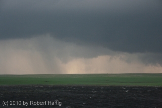
But I’m getting ahead of myself. Let me backpedal a bit to set the stage. After stopping to enjoy the eminently photogenic fourth tornado that followed the beastly Bowdle wedge (see previous post), the four of us headed north to CR2/125th St., then turned east. The storm was morphing into a high precipitation supercell (photo at top of page). We watched it drop a couple more

rain-wrapped tornadoes. Then it pulsed, catching its breath and gathering energy for the next round.

Dropping south down CR9, we pulled aside by a roadside pond to grab a few photos. The updraft area was a couple miles to our west, and while it didn’t presently seem to be tornadic, appearance can be deceptive. The cloud base was low, nearly dragging on the ground, with suspicious lowerings forming and dissipating. It looked like it could drop something at any time, and chances are it was even then producing random, momentary spinups.

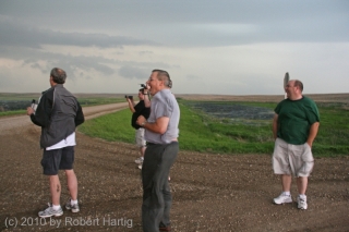
Hopping back into our vehicle, we proceeded farther south to the corner of 130th Street, where we once again parked. Here, we bumped into chasers Ben Holcomb, Adam Lucio, Danny Neal, and Scott Bennett. We had last seen these guys at a truck stop in Murdo; now here they were again, along with several other vehicles, all converging out ahead of the meso in the middle of nowhere. In the photo, left to right: Tom, Ben, Bill, and Scott.

As the storm drew closer, Tom pointed out that rotation was beginning to organize overhead. It was time to skedaddle. Back into Mike’s Outback we clambered, with Tom at the wheel, and headed east down 130th Street.

At this point, it’s important to bear in mind that every vehicle that showed up at our location had independently pre-selected 130th Street as a valid escape route. What followed did not begin as a desperate dash for safety, but as a calculated, run-of-the-mill tactical maneuver informed by commonly used mapping software. Most of the people involved were experienced chasers, some of them veterans. The reasoning behind our road choice was sound. Unfortunately, the information we based it on was not.

Thus it was was that two miles down the road, suddenly there was no road. At the front of a string of other chase vehicles, we were the first to make that

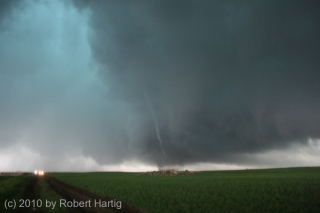
discovery. Tom turned around and started heading back, yelling to the next vehicles that the road was out. It was then that a tornado suddenly materialized in the field maybe half a mile to our west, just south of the road. It was a regular drill press, spinning furiously as it made its way toward us. It finally crossed the road and headed east-northeast a few hundred feet away, but even as it did so, another, thicker funnel snaked to the ground at roughly the same place where the first one had formed. I don’t think most people saw this second tornado; it moved toward us briefly, kicking up dirt, then dissipated, though I could still see swirling motions in the rain bands where it had been.

In the photo, besides the rope tornado, notice the lowerings farther back. These meant business. We were at the eastern edge of a broad area of rotation that was dropping not suction vortices, but multiple tornadoes of various sizes, intensities, and behaviors. In my observation, these were NOT moving in cyclonic fashion around a common center, but east with the parent storm–and straight at us.

A large cone appeared to the west, which, gathering strength, moved through the field to our north. By this time, it was clear that we were in a truly lethal situation, cut off to the east by a dead-end road and to the west by tornadoes.

Windy? Hell yes it was windy. The inflow was cranking like a sumbitch, and from the looks of things, it was only going to get worse. I looked around for a ditch, but there was absolutely nothing that could have offered protection. I noticed a stout post a few yards away and contemplated lying flat and wrapping my arms around it. Tom had the same idea. Mike was eyeballing a large pile of stones a hundred yards away, thinking it might provide some shelter, but it was too far a dash with no time left to make it in.

It was at this point that UK chaser Nathan Edwards drove off the road and began heading south into the field. He told me later that he was simply attempting to clear some room for other vehicles to move forward, hopefully edging just a little bit closer to out of harm’s way, but Nate’s move prompted the rest of us to follow. In a last-ditch gamble, the entire entourage of chase vehicles began fleeing south along the fence boundary.

The tornadoes were close. Really, they were on top of us. I watched as two funnels formed a hundred yards west of our vehicle, twisting around each other and moving toward us like the “sisters” in the movie “Twister.” The rain curtain was full of swirls and braids. And what was particularly unsettling was that, as we dashed across the farmland, the business part of the storm seemed to be expanding, reaching out after us. For a mindless force of nature, this storm was displaying as close as you can get to malevolent intent.

It dawned on me that if ever there was a time to pray, and pray hard, this was it. I’m a Christian–a bit of an iconoclast in that I don’t buy into a lot of Western church culture, but I love Jesus, I’m serious about following him, and conversing with God comes naturally to me. I don’t mean just in a pinch, but as a lifestyle. You can bet that at this point, I began praying most intensely.

A couple hundred yards in, we encountered a wet area and ponding and were forced to forge our way into the cultivated field. It was there that the storm caught up with us in earnest. End of the road for real. There was nothing left to do now but hunker down, pray, and hope.

Obviously I’m here to tell the story. All of us are, every last person. That none of us were killed or seriously injured, or for that matter sustained  so much as a scratch, is in my book God’s love and mercy, pure and simple. A video clip by Adam Lucio shows a tornado forming right in our midst, not ten yards from one of the vehicles. I never saw it, but Adam’s video is conclusive and sobering. We came so close, so very close. The rear flank downdraft alone had to have been in the order of 100 miles an hour. Yet nothing truly bad happened to any of us.

Some may call that a lucky draw; I call it answered prayer. Believe what you will, but there’s more to the story, an experience uniquely mine that I’ve shared with only a couple people so far. Look for it in my upcoming, final post concerning this incident. Whatever you make of it, I think you’ll agree that it’s uncanny.

That’s it for now, but this story continues. What followed with the farmer who owned the field, the sheriff and police, and other locals is for another episode, and it’s still not entirely resolved.

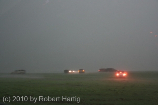
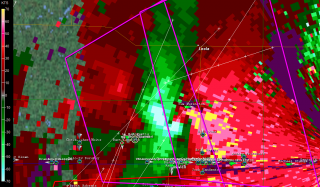
I’ll leave you with two images, both taken when the worst of the storm had just moved past us. One shows some of the vehicles getting slammed by the still-hellacious RFD. The other is a GR3 radar grab of the rotation and our location relative to it, shown by the circular GPS marker.

With that, I’ll sign off. Keep an eye out for parts four and five.

As I Greet the Next Decade: Reminiscences on Thirteen Years of Storm Chasing

Happy New Year, everyone! Welcome to a brand new decade.

With multiple possibilities for my first blog post in the year 2010, I find myself contemplating a recent thread on Stormtrack, and, in the light of it, reminiscing about my own development as a storm chaser.

The thread started with a newbie chaser asking forum members’ opinions about what constitutes a “veteran chaser.” The guy took a bit of a bashing initially, but to me his question seemed innocent, reflecting honest curiosity rather than a preoccupation with labels or a need to earn some sort of merit badge, and it made for an interesting discussion.

And, as I’ve said, it got me to reflecting on my personal path. One by one, the chase seasons have connected to each other like boxcars on a train. It seems incredible to think that 2010 will mark my fourteenth year chasing storms. If years alone were what it took to make a person a veteran chaser, then I might qualify.

But years alone do not a veteran make–at least, not in my opinion. A veteran road warrior, yes; a veteran storm chaser, no. There are plenty of people who have been chasing a shorter time than me, but who have acquired far more skill and experience. As for me, I’m just a slow but happy learner who’s too low-key to mess with light bars.

However, the span of time I’ve been chasing has allowed me some formative experiences I probably wouldn’t have had if I had started more recently. Today, it seems like the average neophyte steps into the field equipped, if not with knowledge, at least with a laptop, GR3, GPS, and an aircard. He or she has a technological edge that didn’t exist, or that barely existed, back when I was getting started.

I now realize that the simplicity and constraints of those first, low-tech years have left me with a gift of memories. I treasure those thousands of miles I traveled–sometimes by myself, sometimes with Bill and/or Tom Oosterbaan–equipped with nothing more than a weather radio, a portable black-and-white TV set, high hopes, and an eye on the sky.

Radar? I stopped at local libraries and airports and got my fix. I had no idea how long a radar image would be good for, how much difference four-and-a-half minutes and a single scan could make. Today I just shake my head and think, no wonder I never saw any tornadoes. It’s a wonder I managed to see a stinkin’ cloud.

As for forecasting, that consisted of looking at SPC outlooks and then steering for the middle of a moderate or high risk area. At some point, though, I discovered my first link to a site for forecasting models, and an interesting–and daunting–new window opened up. Suddenly, here was a bewildering suite of data–surface dewpoints, BRN shear, CAPE, lifted indices, helicity, 300 mb winds…alchemy, pure alchemy, and in a variety of flavors at that. GFS. ETA. RUC. Hoo boy, talk about dumping a load on my head!

Around that same time, I attended my first severe weather conference at College of DuPage. As I recall, Chuck Doswell conducted a workshop on hand analysis and Eric Rasmussen shared some findings from the first Project Vortex. By then, I knew just enough acronyms and concepts to make sense out of some of what was getting thrown at me. Much of the value lay simply in being exposed to the actual stuff of operational forecasting and severe weather research. There’s something to be said for sheer exposure; even if a body grasps just a fraction of the concepts he encounters, what matters is, it’s a start. I left that conference, and the one that followed it a year or two later, equipped with a little more awareness and a little less ignorance than I had coming in.

My first successful tornado intercept occurred in my first season as a chaser, in 1996, in my home state of Michigan. A wall cloud formed directly south of my workplace, and I left work early to chase it sixty miles to where it put down a beautiful tube out in the open countryside near St. Johns. The storm was a classic supercell, as nice as anything I’ve seen out on the Great Plains, though at the time I had no ground for comparison and knew nothing about storm modes or morphology.

It would be another ten years before I witnessed my next tornado in 2006, as Bill and I tracked the historic Six State Supercell from west of Columbia, Missouri, all the way back to Michigan. Prior to that, I had roamed my state and neighboring Indiana, and pounded the flatlands of Illinois, with just a handful of wall clouds and a growing awareness of storm structure to show for it. The year 2005 was my first excursion across the Mississippi and my first experience watching storms explode along the dryline in central Kansas.

But 2006 was the year when things finally started coming together for me, and I think that Bill–my consistent chase partner for all these years–would say the same, since our personal learning curves have been closely tied together. By then we were using Bill’s business laptop and had access to NOAA radar. I had just discovered the significance of velocity couplets, although, not yet understanding the benefit of using storm relative velocity over base level velocity, I was using the latter. Again, it was a start, and the base level gave us enough data to keep us from very likely getting blown off the road by the Springfield, Illinois, tornado as Bill and I chased the Six State Supercell.

A month later, we intercepted tornadoes in Iowa, including another large, night-time tornado that did F2 damage in Iowa City.

That same year, I acquired my own laptop, and the following spring I added GR3, and from there on, my learning and experience curve began to snowball. Today, as I look at where I started and where I’m now at, I realize that I’ve learned a few things. I’ve gained another great chasing partner in my buddy Kurt Hulst. I’m making my own forecasts with increasing knowledge and accuracy. I haven’t seen a lot of tornadoes, but I’ve seen my share, and I trust that, by God’s grace, I’ll see more, as well as endure more busts and make more idiotic choices that cost me storms I could have had.

So, getting back to the question of what makes a veteran chaser, I’m firsthand proof that there’s more to it than just the number of years a person has been chasing storms. In my opinion, there are actually three components to being a veteran storm chaser:

1. Really, really knowing what the heck you’re doing,

2. Many years of doing it, and

3. Lots of successes and lots of failures to show for it.

I probably fulfill the second criterion. As for the other two, well…I’ve got a ways to go, but I’m working on them. Give me another ten years and maybe the hat will fit. It really doesn’t matter, though. As a general rule, chasers who are worth their salt don’t give a flip about labels. They’re driven by storms, not status. Certain names are indeed revered–icons such as Tim Marshal, David Hoadley, Roger Edwards, and Gene Moore. As for the rest of us mortals, I think that those who’ve been at it a for a while respect others who have paid their dues. We know the names, if not the actual faces, and recognize the shared passion and personal investment behind those names. The countless miles traveled. The commitment to learning and growth.

Above all, the love for the storms that keeps us dreaming all through the winter, and that, in the spring, calls us once again toward the open skies, the tumbled clouds, and the hope and promise of the Plains.

[XUB6K3AQNFKD]

New High-Resolution Level 3 Radar Coming in February

Last night Grand Rapids got its first snowfall, and this morning I switched the color tables on GR3 and GR2 to winter mode.

Ugh. I suppose that blue, pink, and purple are going to rule for the next four months. I much prefer plenty of yellow, orange, and red, at least when it comes to radar displays, but we’re at that time of year when those colors aren’t likely to be very meaningful, El Nino or no El Nino.

While switching color tables is relevant to me as a Michigan resident who’s bracing for the winter, it’s nothing compared to the changes coming down the pike for GR3 and other level 3 data users in February. Here’s a message that Gilbert Sebenste of Allisonhouse, a well-known private supplier of raw radar data, posted in the AH and Stormtrack forums:

We have just been informed by the National Weather Service that starting in February 2010, and lasting through April, 2010…the National Weather Service will add higher resolution Level3 radar data products, replacing quite a few of the ones you use right now. The legacy products will continue to be sent for 6 months after all of the replacement products have been added, and will be discontinued on December 1, 2010.

What it all means in a nutshell is this:

1. Resolution will increase
2. The number of reflectivity levels will increase to 256 (meaning you will need to have 256 colors in your color palette to display all the intensity levels)
3. The volume of the files will double, on average
4. The Level3 format will change
5. It will be completed by the end of March, 2010…with legacy products ending 12/1/2010.

Allisonhouse will be working closely with its software partners to provide a seamless as possible transition to the newer and better products upon receipt of transmission from the National Weather Service, and we will provide you with more information as it becomes available.

Wow. Now those, folks, are changes, and it looks like they’ll be here right in time for storm season 2010. High-res level 3–imagine that! My one issue with level 3 has been its coarseness, but that problem is about to be solved. Within a few short months, level 3 data will be coming to us with the same finely shaded resolution as high-res level 2 while remaining a usable product in the field, which is what GR3 is designed for.

Of course, no chaser is going to love the idea of doubling the file sizes. But the improvements look to be awesome, and will give us much more detailed images of storms.

Other Changes on the Way

.

Exciting as the rapidly approaching implementation of high-res level 3 data is, it’s not the only significant development on the horizon. Next year will also see a major phasing-in of dual-pole radar to WSR-88D stations throughout the country. And in the private sector, Andrew Revering of Convective Development, Inc., is working on a huge upgrade for F5 Data forecasting software.

In summary, the technical/informational side of storm chasing will be seeing some significant advancements in the coming year. However many of those improvements are ready for next spring’s severe weather season, let’s just hope that the storms themselves put in a decent appearance.

GRLevelXStuff Has Returned!

Users of GR3 and other Gibson Ridge radar products, rejoice! GRLevelXStuff.com has returned!

A couple months after the site’s disastrous crash, I had pretty much concluded that Aaron et al had given up on it as too time-consuming and costly to resurrect. But tonight, just on a whim, I clicked on their bookmark, and lo and behold, there was ‘Stuff in all its glory.

If you’re already familiar with GRLevelXStuff, this should be good news indeed. If you’re not in the know about it and you use GR3, GR2, or GR2AE, then you definitely need to get acquainted with the site. In its past incarnation, before the disastrous crash that wiped out the entire database, barring the stuff that Aaron had saved on his hard drive, ‘Stuff was the premier support forum for Gibson Ridge users. It was a massively helpful resource in terms of both knowledge and applications. The color table section alone was enormous, and the background section of topo maps couldn’t be beat.

So this is my plug for the reborn GRLevelXStuff. Aaron and his team are hard at work rebuilding it, and such a project requires a community effort. If you use a GRL product, I urge you to visit the site, give the lads a well-deserved thumbs-up, and get involved. Registration–or re-registration, if you were a member of the pre-crash site–takes just a second.

One other thing: if you can afford to, please make a donation. It’s very easy to do so, and every dollar will help. GRLevelXStuff provides a terrific service, and it’s well worth getting behind with your dollars as well as your goodwill. Aaron has been upfront about the costs involved in recreating and maintaining the site, and the need for financial assistance. I just dropped my farthing in the collection basket, and I hope you will, too, if at all possible. Let’s do our best to help make the new ‘Stuff better than ever.

The Lake Breeze Zone and Severe Weather

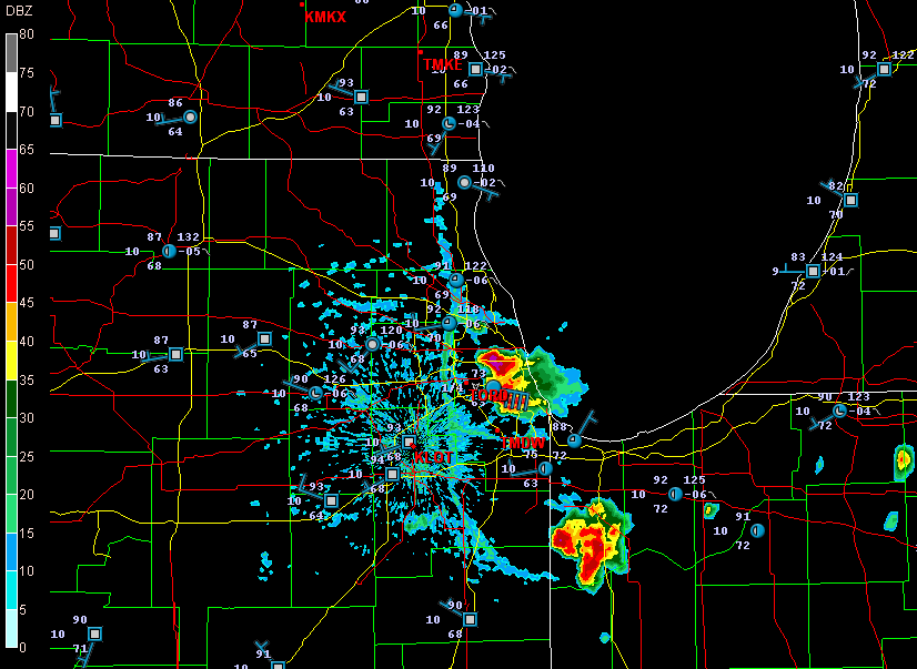
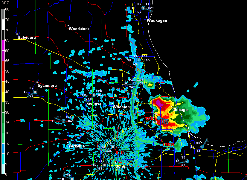
Earlier today, I opened up GR3 just out of curiosity and noticed some blobs of convection along the Lake Michigan shore by Chicago. Here are a couple radar grabs.

lake-breeze

lake-breeze1

These images interest me for several reasons, all of which have to do with a Great Lakes phenomenon called the lake breeze zone. The lake breeze zone is not a fixed area. Its boundaries are atmospheric, not geographic.

And boundaries truly are what it’s all about. Probably the most immediately noticeable feature on these radar images, besides the obvious storms, is the north-south boundary set up by the onshore breeze. It’s a great point of convergence where overall westerly surface winds butt up against backing winds from off the big lake. You can see how outflow from the storms that have fired up within the lake breeze zone interacts with the lake breeze boundary.

Another less immediately obvious by-product of the lake breeze zone is helicity. Notice how the wind barbs farther inland are all westerly, but inside the lake breeze zone, they’re easterly. Now, I’m no expert on this stuff, but I know enough to recognize the potential for localized helicity to occur even when the large-scale flow is unidirectional. During the day, strong thunderstorms can go tornadic when they encounter a backing onshore breeze near Chicago, along the Wisconsin shoreline, and along the Lake Huron and Lake Erie shores of eastern Michigan. The same can happen in the evening along Michigan’s western coast as the land cools and an offshore breeze prevails. Many times I’ve noticed the NAM and RUC showing a small sigtor centerered over Berrien County when there are no sigtors anywhere else in the region, and I’m sure this phenomenon is largely due to the lake breeze in that area.

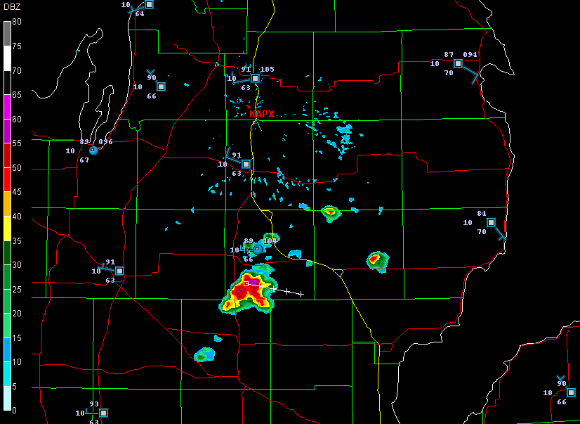
Right now I see storms firing up farther north around Gladwin and Roscommon.

storms

A glance at the Gaylord VWP shows west winds neatly stacked from the surface on up. But look at the METARs along Lake Huron. Without much in the way of bulk shear, the storms are subsevere, just little popcorn cells. But it will nevertheless be interesting to see what comes of them as they work their way into those backed shoreline winds. You just never know.

Remembering the Parkersburg/Hazleton Tornadoes

One year ago today, the second EF5 tornado in the history of the new Enhanced Fujita Scale rating system descended on Parkersburg, Iowa, and obliterated the southern third of the town. I and fellow storm chasers Bill and Tom Oosterbaan and Jason Harris could see the intense rotation moving over Parkersburg on GR3 as we stairstepped southeast from the northern edge of the cell, heading for an intercept. There’s a certain sense of disbelief when you see something like that, a feeling of, Naah, it can’t be as bad as it looks.

But it was. A few miles farther down the road, with the rotation still at least ten miles to our west, debris–some of it fairly large–began to fall from the sky. That was when we knew for sure. Something terrible had happened. Even with pieces of sheet metal clanging down onto the pavement in front of us, I had a hard time believing that a tornado disaster had just occurred, but I think we all felt a certain sober awareness that a community had been hit.

We intercepted the storm near Fairbank, where the NWS indicates that the Parkersburg tornado occluded. Parking on a sideroad, we watched as a large, new wall cloud formed and moved directly toward us. Warning an Amish family who was standing in their yard, watching, to take shelter, we scooted south and then east, watching as the wall cloud lowered and kicked up a ton of dust. A second, enormous tornado had formed, barely discernible through the haze. We tracked with it to the east as it headed on a collision course for Hazleton, mercifully grazing the southern edge of that town. Had it hit head-on, I suspect that the Hazleton tornado’s EF3 rating would have been higher.

It’s hard to believe that a whole year has passed since that event and the several days of Great Plains action that preceded it. What a difference between then and now, with a nasty ridge casting a pall on this May’s peak chase season.

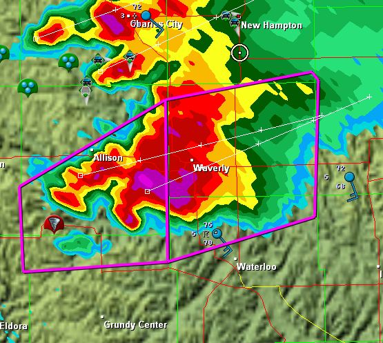
In remembrance of the Parkersburg/Hazleton tornadoes, I’m including a couple visuals. The first is a radar grab of the supercell as it moved out of Parkersburg. The tornado icon is a storm report from the town, just minutes old. You can see our GPS position marked by a circle with a dot in the middle of it on the northeast edge of the storm

The Parkersburg, Iowa, tornadic supercell.

The Parkersburg, Iowa, tornadic supercell.

The second is this YouTube link to my video of the Hazleton tornado. My videography may not be the best in the world, but I think you’ll get a sense of the intensity this storm evoked. It was my first really big tornado, and it was close.

I doubt this year has anything in store for us  like what we saw that day. But who knows? I’m not ready to write off this chase season yet–though I certainly hope it doesn’t hold a catastrophe like the Parkersburg tornado.