Things a Jazz Musician Never Hears Anyone Say

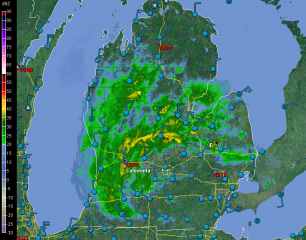
You see this? It’s a rare phenomenon in Michigan called “rain” (pronounced rayn). It began yesterday as a closed 500 mb low settled in over the state, and it looks like it will be with us for a while, as the low seems content to linger. You can see a hint of cyclonic swirl on the radar.

And that’s not all: as I write, just a quarter past noon, the KGRR station ob shows a temperature of only 57 degrees. After a heat wave that has stretched from June into early August, with temperatures in Michigan exceeding the 100-degree mark at times, suddenly it looks and feels like autumn. Yesterday I traded my shorts for blue jeans. Even during a normal summer, that rarely happens.

After a historic, severe drought that has mummified Michigan and crippled much of our nation, this steady rain and respite from the heat is beyond welcome. It is a godsend, and those of us who believe in God thank him for it. “He sends his rain on the just and the unjust”–and to the just and the unjust alike, it is a great beneficence.

Next week there’s the possibility of a trough digging down from Canada across the northern-tier states, with jet energy bringing the potential for severe weather in the Great Lakes sometime Wednesday and/or Thursday. But that’s far from certain at the moment. The GFS has painted some wildly varying scenarios, and the most I can see right now is that both it and the ECMWF agree on troughing, with the Euro painting the more potent picture.

Okay, enough of the weather. Let’s talk about music. A while ago, I posted a status update on Facebook that struck me as pretty funny. I have a great appreciation for my own sense of humor, which is a good thing because it means that I have at least one fan. What I hate is when I tell a really hilarious joke and then I don’t get it. Then I have to explain the punch-line to myself, and that just ruins it. Fortunately, that doesn’t happen often. Most of the time, I break out into spasms of laughter, and people look at me oddly, and … getting back to my Facebook post: I figured that I’d share it here and then add onto it whenever I feel inclined. Feel free to post your own additions in the comments section. Without further ado, here are …

Things which, as a jazz musician, I have yet to hear someone say:

.
“Could you turn up the volume? You’re not loud enough.”

“For our first dance, we want you to play ‘Giant Steps.'”

“You want $100 per musician to play at my club? Is that all? I’m doubling your rate. It’s about time you musicians gave yourselves a cost-of-living raise.”

“First tahm playin’ hyeer at the Eyegouge Saloon, eh? Well, I hope yew boys play a lot of Ornette Coleman. Folks hyeer get mighty disturbed if’n they don’t get their Ornette. And another thang: do NOT, if yew value yer life, play ‘Free Bird.'”

“I know we’re an all-white church praise team with three guitars, but we only like playing in the flat keys.”

“What t’hell you mean, you don’t have a trombone player? How can a jazz band not have a trombone? Tell you what: you come back next week with a trombone player and I’ll shell out an extra hunnerd-fifty bucks.”
Guest Blog: Storm Chaser Andrew Revering on How to Forecast Northwest Flow Events

Regarding tornado potential…with storms moving southeast or even south in some cases, you have to keep in mind that the storm-relative inflow will have to shift in order to maintain a good, dry updraft and support supercellular structure.

Welcome to the first guest post in my new, improved Stormhorn.com blog! I’m pleased to feature Andrew Revering sharing his insights on forecasting northwest flow chase scenarios. Northwest flow seldom produces severe weather; however, some noteworthy tornadoes have occurred in northwest flow. I’m delighted to have Andy share his knowledge about how to forecast the rare chaseworthy setups.

Andy is the proprietor of Convective Development, Inc., and the creator of the unique, enormously powerful F5 Data forecasting data feed and software. A meteorology student both privately and in educational institutions for his whole life, Andy has been a storm chaser for 15 years, four of which he served as a contract storm chaser for KSTP, an ABC-TV affiliate in Minneapolis. Andy started writing weather software in 1996 as a high school senior, developing such programs as AlertMe, APRWeather, WarnMe, StormGuide, AlertMe Pro, SkyConditions, and F5 Data. His current projects include F5 App, F5 Maps, and CellWarn.

During the nearly three years that I’ve used Andy’s F5 Data, I’ve been impressed not only with the power of the product, but also with the knowledge, friendliness, and helpfulness of its creator. Without further preamble, here he is, helping you to get a better handle on…

FORECASTING CHASEWORTHY NORTHWEST FLOW SCENARIOS
By Andrew Revering

The weather pattern known as northwest flow often means cold, stable air and clearing skies, since it comes in the wake of a large synoptic low that has just come through, cleaning the atmosphere of moisture and instability. However, on rare occasions northwest flow can produce very photogenic supercells and even tornadoes.

A northwest flow setup is normally undesirable for storm chasing because severe weather typically occurs in the warm sector before a synoptic system passes, with the jet coming in from the southwest. After the system passes, the shifting jet structure puts you into the northwest flow with limited moisture and instability. With desirable surface features now to your east, you will typically have scrubbed the atmosphere of any good moisture and instability, thereby preventing severe weather from occurring.

However, this is not always the case. A weak ridging pattern, for example, can also produce northwest flow, and it’s possible for weaker surface systems to traverse the flow, bringing in adequate moisture and instability to create a chaseworthy setup.

Regarding tornado potential, the concerns to look at from a forecasting perspective are the same you would consider with a typical deep trough/southwest or westerly flow scenario. Check for adequate deep shear and low-level shear (helicities, 1 km shear vectors, etcetera). You also want to look at the storm-relative inflow. However, with storms moving southeast or even south in some cases, you have to keep in mind that the storm-relative inflow will have to shift to maintain a good, dry updraft and support supercellular structure.

Keep in mind some basics. In order to sustain a single-cell or supercell structure, besides having decent deep-layer shear (40-plus knots at 6 km depth vector), you should also have the environmental wind directions blowing at an angle, with storm motion at roughly ninety degrees from the direction of the environmental winds.

For example, in a classic scenario, storms move due east, with surface winds moving from the south. This allows unstable, warm, moist air to enter the storm on the south side. The storm moves east because the upper-air steering winds are pushing it in that direction. Therefore, when the tower of the storm goes up it gets tilted downwind to the east of the updraft, and rain falls ahead of the storm.

That’s the key point here: rain falls ahead of the updraft. So when you have warm “feeder” air flowing toward the southern side of an eastbound storm, that air can enter the storm unobstructed by precipitation, thus allowing for warm, buoyant air to drive the updraft.

Conversely, if the surface winds came from the east of this same eastbound storm, you’d have storm-relative inflow at 180 degrees. This is BAD for a storm when it comes to producing a tornado, because the incoming air is encountering all of the cold outflow produced by the rain core. It cannot effectively get around this obstacle to feed the updraft. So two problems occur: 1) the warm environmental air gets blocked by the outflow; and 2) the inflow speed decreases, which in turn greatly decreases the low-level shear vector.

Think of it as an extreme. If outflow blocks the environmental winds completely you have zero knots of inflow air into the updraft, which becomes contaminated by the outflow.

In this scenario, the warm air still gets into the storm to feed it, but the storm becomes front-fed, with the warm inflow riding up over the cold outflow. It enters the storm at the mid levels, pushed there by the outflow/gust front, which creates a wedge and causes a shelf cloud to form. The storm then becomes outflow-dominant—linear, multicellular, or some other mode that is unfavorable for tornadoes.

To summarize, then, you need the environmental wind direction to be entering the storm at an angle between, say, 45 and 135 degrees of a storm’s motion to help the storm maintain a super-cellular shape (along with good deep-layer shear and other parameters).

Applying these general principles to a northwest flow event, if your storm motion is southeasterly, south-southeasterly, or southerly, you need storm-relative inflow to be west-southwesterly, westerly or possibly even easterly or east-northeasterly. Since the storm motion is usually going to be southeasterly, the westerly surface options are typically the better choice.

This seems illogical to most chasers. These are not the typical directions you would expect for good inflow; however, they can work well if you have enough instability, moisture, and other of the right ingredients.

When chasing northwest flow storms—or any storms—keep in mind that you want to be on the side of a storm where the environmental inflow is approaching the storm. In a classic setup with an eastbound storm and southerly surface winds, you would look for the updraft base on the south side of the storm (though that can vary from the southeast to southwest side of the storm as well). In a northwest flow scenario, if the surface winds are west-southwest, look for your updraft base on the west-southwest or west side of the storm if its moving south, south-southeast, or southeast. This arrangement can be disorienting to a chaser who doesn’t normally chase storms moving in these directions. In northwest flow, the south or east side of the storm will have few features and present what looks like an outflow-dominant storm, making it easy to miss the tornado on the other side.

Northwest flow storms can be good tornado producers for another reason that I haven’t mentioned yet: they typically bring in cool air in the mid levels. This cool air advection greatly increases instability provided there’s good moisture and instability at the surface. Getting the right surface conditions in place is difficult, but those conditions are the key factor in a good northwest flow setup. Surface moisture and instability combined with unusually cold temperatures in the mid levels can add up to decent instability overall.

Additionally, if the mid levels are cold enough—say, less than -16C at 500mb—you may get a ‘hybrid’ cold core setup to amplify the scenario. However it probably wouldn’t be a true cold core as defined by Jon Davies’ work, given the presence of northwest flow and the likely absence of a significant mid-level cyclone in the area.

Most northwest flow setups occur in June, July, and August, with the peak being in July. These three months account for 85 percent of northwest flow events as studied by Kelly et al, 1978. It is pretty evident that the delay in northwest flow setups during the severe season is due to the lack of adequate moisture in earlier months. In the summer you can get an adundance of moisture that lingers after the passage of a system, allowing for a northwest flow system or even a post-frontal storm or two.

Storm chasers often ignore northwest flow patterns because they typically mean few low pressure centers for convergence and moisture fetch. But while severe weather is rare with northwest flow, it can occur. So keep an eye out. You can easily miss a decent chase scenario by writing it off too quickly.