Quick Summary of Wednesday’s and Thursday’s Chases

Five days and nearly 3,000 miles later, I’m back from out west. This storm system proved to be a disappointment, but it did have its moments. Bill Oosterbaan and I intercepted a nice low-topped supercell in northeast Kansas on Wednesday night, and it’s possible that we witnessed a brief tornado. I need to scrutinize the brief footage I got of the storm feature in question. What was unmistakable was the broader circulation of the storm. It seemed weird to be chasing a north-moving storm with inflow from the northeast, but that’s how it was with storms that moved along a warm front–apparently across it–near a low center with a 500 mb closed low in the vicinity.

Yesterday was a more typical setup. We targeted the Muskogee, Oklahoma, area, which the SREF and RUC pointed to as offering the best overlay of instability and mid-level support, with the H5 jet core nosing into the region.

We were right on the first storms as they initiated, but they were feeble things that just couldn’t seem to get their acts together. With a long drive home lying ahead of us, we concluded to start heading north and settle for a nice lightning show on the way home.

But our prospects improved as the 500 mb jet began to strengthen. A couple of cells to our west and northwest intensified and began to take on a telltale appearance on the radar. A handful of scans later, rotation started to manifest on SRV. By this time we were on US 59 north of the Grand Lake of the Cherokee, east of Vinita and directly in the path of the southernmost cell. At a side road, we pulled aside and I tripoded my camcorder and videotaped some nice storm features: pronounced beaver tail, tail cloud, a nasty-looking wall cloud, and a wet RFD notch.

Beginning as a classic supercell, the storm looked for a while like a tornado breeder. But after predictably morphing into an HP, it eventually lined out and got absorbed into the wad of convection springing up to its south. Lack of adequate helicity is probably what kept this and other storms non-tornadic. METARs showed backed surface winds in the vicinity of the storms, but from what I observed, surface inflow was non-existent to weak. Hodograph curvature doesn’t matter much if boundary layer wind speeds are puny.

I have a few photos to process that I’ll slap up in a day or two, possibly along with a radar grab or two. Right now, though, I’ve got some work I need to accomplish before the work week ends, so here’s where I sign off.
Michigan in the Crosshairs Today?

Most of the time when I chase storms in Michigan, it’s as a wannabe sitting in my armchair gazing wistfully at my radar as I follow the action out west. Every once in a while, though, I get something right here in my own state that’s worth hopping into my car and driving after with my laptop and camera at hand and hope in my heart.

Today is shaping up to be such a day. It’s about time. June is upon us, and that means the peak tornado season has finally arrived for Michigan. Frankly, that term, “peak tornado season,” strikes me as glaring overkill when it comes to Michigan. But we usually have a few incidents every year, and today could be one of them. Perusing the last couple of NAM runs, including the 00Z, and running a few model RAOB soundings, I’m casting my eyes on the Flint-Pontiac area, where surface winds appear to remain, if not backed, at least southerly at 00Z tomorrow evening.

With dewpoints at or exceeding 65 degrees below a warm front draped across central Michigan, straight westerly mid- and upper-level winds with 45-50 knots at 500 mbs, and forecast SBCAPE upwards of 2,000 J/kg, there certainly look to be some decent ingredients in the vat. Insolation will be either the eye of newt that either makes the magic happen tomorrow or the missing ingredient that quashes instability thanks to blowoff from storms farther west.

no images were found

Attached are a couple soundings, the first for 23Z at Flint and the other for 00Z at Pontiac. Not bad-looking hodographs, particularly for Michigan. As you can see, the surface winds are southerly. Farther west, they veer to the southwest, though they by no means create a unidirectional scenario. Interestingly, while the STP and Stensrud Tornado Risk indices spotlight the area around Flint, F5 Data’s APRWX tornado index bullseyes Grand Rapids down toward Kalamazoo. Maybe that’s because a 500 mb jet max noses into this area by 00Z.

no images were found

Traditionalist that I am, I prefer backed, or at least southerly, surface winds if I can get them.  So as of the 00Z run, I’m eyeballing parts east, probably up around Flint near the warm front. The morning run may tell a different story. I just hope it’ll be a positive one.

Here’s to sunny skies, decent CAPE, and a good, productive backyard chase!

ADDENDUM: I wrote the above last night. The morning picture changes things a bit. Specifically, the satellite shows a nasty batch of CAPE-killing clouds blowing into the area from an MCS out west. That’s bad news. However, the clouds show some clearing expanding in their midst. That’s good news. Moreover, Mike Kovalchick sent me an HRRR model radar image showing a supercell popping up in mid-Michigan at 22Z. I’m sure that’s dependent on decent CAPE, which presumes enough clearing for good afternoon heating.

This latest info is good to have, but it doesn’t change my game plan, which is to wait and see what happens by the afternoon.

Radar Grabs from March 10 in Arkansas

Yesterday morning at 8:30, I looked at the RUC and the NAM, shook my head, and then headed out the door anyway to go bust chasing in Illinois. Chalk it up to a long Michigan winter or just plain foolhardiness, but there are times when I just have to go, period. Set out with my expectations low and hang my compass on nothing but hope, with the mindset that I’ll be grateful just to get a flash and a rumble. That’s what my buddy Bill and I got yesterday, and I’ll tell you, it was nice.

no images were found

The day before, March 10, the same storm system delivered a considerably higher level of intensity as it moved through Arkansas. Those meager-to-modest dewpoints managed to produce a nice little swarm of supercells on the nose of a handsome 500 mb jet, and several tornadoes spun down.

I didn’t chase that day, but I made a point of following things at home, and I happened to capture a few level 2 images of the day’s main bruiser near Searcy, about 50 miles northeast of Little Rock. The images were taken around 0235 Z (8:35 CST). Note the interesting “hammerhead” hook on the first reflectivity image. Beyond that, I’m not going to say more, just offer you the screen grabs for your viewing pleasure, along with some exciting memories for those of you who were on that storm.

no images were found

no images were found

no images were found

Rotten Nice Weather We’re Having

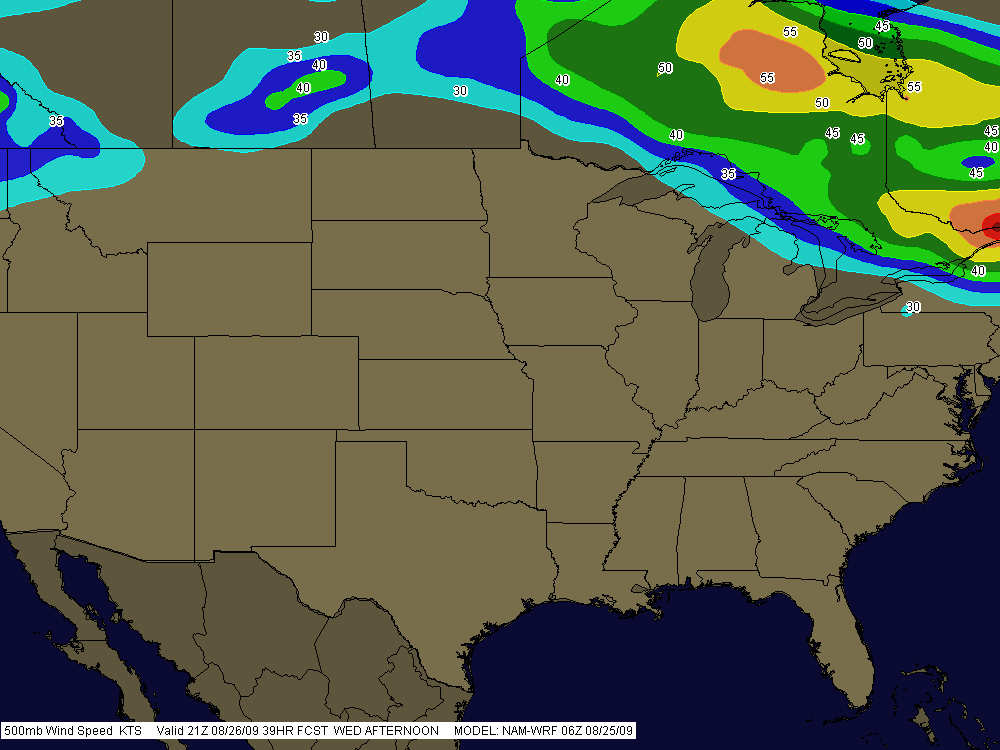
Boy, is it ever summer. The day has dawned a glorious blue, with nothing in the way of convective mayhem in sight anywhere in the nation. Nothing but pop-up thunderstorms on the menu for today here in Michigan, and the 500 mb jet is like a limbo bar raised high enough for most of the CONUS to squeeze under.

SummerPattern

It’s what you expect this time of year, and it’s what we’re getting. The SPC’s long-range outlook is calling for possible troughing by the weekend, so maybe we’ll see a round of severe weather yet. Who knows. But I’m not making any plans. This is August. Might as well be January so we can get winter over and done with, except…well, there’s still always hope this time of year, and the late season to look forward to.

So why am I writing when there’s nothing to write about? Just to wish you a nice day. Enjoy this beautiful weather we’re having here, cuss the luck.