My July 27 Michigan Tornado Video, for What It’s Worth

Michigan is not Oklahoma. It is not even Illinois. If you’re a storm chaser who has any life experience with this state, as a few of you do besides me, you know exactly what I mean. Had Dorothy and Toto lived here instead of in Kansas, The Wonderful Wizard of Oz would never have been written. That or else author L. Frank Baum would have had to find a dfferent means of lofting his main character and her little dog somewhere over the rainbow.

Sure, Michigan gets its annual tally of tornadoes. It’s just that most of them are something less than what you’ll encounter west of the Mississippi or down south in Dixie Alley. That’s not a bad thing, given our population density. But it does require Michigan-based chasers to either travel long distances out of state or else languish from convective malnutrition.

You want to see a Michigan tornado? Okay, I’ll show you a Michigan tornado. But be forewarned, it’s not a pretty sight. It’s barely any kind of a sight at all. When I first spotted it, I wasn’t even certain it was a tornado, though after reviewing my HD clip and getting a couple of other reliable opinions, I’m now convinced. Good thing, too, because it’s all I’ve got to show for this year in terms of actually seeing a tornado. That’s pretty pathetic, considering the chase opportunities that circum 2011 has presented. But you can’t chase when your 85-year-old mother is having a knee replacement, as mine did on April 27, the day of the 2011 Super Outbreak; or when you just don’t have the money to go gallivanting freely across Tornado Alley, a reality that has badly limited me this year.

Given such circumstances, you grab what you can, where you can, when you can. July 27 was an example. Although a light risk tapped on the very westernmost edge of Michigan, my state was for the most part outlooked for nothing more than general thunderstorms. Severe weather wasn’t a concern. So imagine my surprise when I spotted distinct rotation on GR3 in a cell just to my southwest, heading ESE toward Hastings.

Grabbing my gear, I hopped in my car and headed east, setting up my laptop on the way. And what do you know! The radar didn’t lie. The storm had a large, well-defined wall cloud that I caught up with as I approached Hastings on State Road.

Since my video clip doesn’t show much in the way of structure, let me assure those of you who care about such things that this storm had good visual clues: impressive wall cloud, crisp updraft tower, and a warm RFD cascading off the back end. As I’ve already mentioned, storm motion was ESE, which corroborates my recollection of a northwest flow regime and explains why the rotation was more on the northwest part of the cell than the southwest. Also, as I recall, surface winds were from the SSW, though I can’t say how they were behaving ahead of the updraft area as I never managed to outpace the storm.

With all that said, here’s what happens in the video: Heading south behind the storm, I first spot the tornado out of my side window, which is covered with raindrops. Those somewhat obscure the funnel, but you can still make it out as a small, faint, whitish blotch connecting the cloud base to the treeline a little ways to the right of center. At this point I’m debating with myself and conclude that the feature is just scud. I park the car, zoom in on the storm and lose focus, then roll down the window and zoom back out. You’ll then see a small sapling mid-screen, and the tornado still barely visible to its right as a tiny strand of light gray condensation set against the darker background. It, translates almost imperceptibly to the right for a handful of seconds before vanishing. In my HD clip, I can make out something of an actual rope-out, but you can’t tell with YouTube.

Nevertheless, even though YouTube isn’t great for detail, I think you’ll see what I’m talking about overall. I promise you, it’s there; you just have to look closely. And use your imagination. And be highly suggestible. And believe in the Tooth Fairy. (I’ve also got some clips of Sasquatch and the Loch Ness monster that you may take an interest in, but those are for another time.)

The tornado doesn’t appear in the day’s storm reports, and I don’t believe the supercell that produced it ever got severe-warned. I think I was the only chaser on the darn thing, at least from my side of the state. I did report the wall cloud to GRR. I never bothered with the tornado because it was there and gone before I’d made up my mind what it was. It certainly was an anemic little puke, and I’m not sure whether to feel grateful that I scored at least one tube this year or to feel mortified about even claiming it. I almost felt sorry for the poor thing, and if I could have, I’d have taken it home and cared for it until it was healthy, and then released it under some nice, beefy updraft tower while strains of “Born Free” played in the background.

Go ahead and laugh, but I’m probably the only chaser in Michigan who got video of this tornado. Then again, that’s nothing to brag about, particularly in a year when so many chasers have captured videos of violent, mile-wide monsters. It’s just, like I said, all I’ve got to show. Yeah, I was there with my buddies right by the airport when the April 22 Saint Louis tornado hit, but none of us actually saw a funnel. I doubt anyone did after dark in all that rain. So July 27 is it for me, my sole visual record. Mine, all mine. Bob’s tornado. I’ve assigned it an F6 on the original Fujita scale, F6 being a hypothetical rating associated with “inconceivable damage.” That description fits perfectly, as this tornado was practically hypothetical, and it’s inconceivable to me that it could have damaged much of anything. Maybe snatched up an ill-fitting toupee, but that’s about it.

So there you have it: a genuine Michigan tornado. Now you know what storm chasing is like here in my state. It’s just another of the great perks that this supercell haven has to offer besides its economy.

I will say this: we do have fantastic craft beer.
Tornadoes in North Central Nebraska

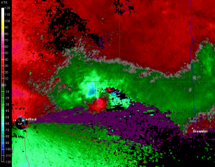
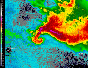
With family visiting from various long-distance places of the globe, I’m not posting much these days. However, last night provided an interesting spate of late-season tornadic activity in north-central Nebraska that I’d be remiss in not slapping up a couple images from GR2AE at the peak of the activity.

Look at that pinhole in the reflectivity knob! I was even better defined in the ensuing scan, after which the rotation became more diffuse and the storm began to weaken. Prior to this, a few dedicated and fortunate chasers videotaped a nice

stovepipe tornado near Wood Lake. All this in northwest flow with the storms moving in a south-southeasterly direction.

First Public Speaking Engagement

Yesterday morning I delivered a presentation on storm chasing for the residents of Covenant Village, a retirement community on the west side of Grand Rapids. The event was my baptism as a public speaker, and it went very well. The positive comments I received encouraged me that I did a good job for a greenhorn. But then, I had a compelling topic and plenty of material to make up for my lack of experience behind the podium.

I spent most of the previous day organizing my notes and photographs. By the time I was finished, sometime around midnight, I had a collection 37 images, including two radar screens. I also had seven pages of notes that covered

• who storm chasers are, what they do, and why they do it; and my own growth as a storm chaser;

• severe weather in Michigan, using this year’s May 29 straight-line wind event in Battle Creek as an example;

• basics of a tornadic supercell, tracking the June 5, 2010, Elmdale, Illinois, storm from initiation to tornadogenesis to impact on a small community;

• and finally, my most intense personal experience to date, that being May 22, 2010,  in “The Field” near Roscoe, South Dakota.

Inviting my audience to interject with questions made for more organic, interesting communication. A number of  people responded with some excellent questions, and I liked how those freed me from the tyranny of my notes. I really don’t like to getting my nose stuck in a pile of notes–they interrupt my flow. Hopefully I’ll get more speaking opportunities, and those will help me to internalize my material, at which point I’ll be able to jettison the notes entirely.

At the request of organizer Linda Kirpes, I concluded my talk with a rendition of “Stormy Weather” on my saxophone, followed by my theme song, “Amazing Grace.” Probably most speakers don’t cap their presentations in such fashion, but it suited me, and I’ll do it again if I get the chance. The storm and the horn of “Stormhorn” go together, after all.

The Historic 2011 Tornado Season in Review: A Video Interview with Storm Chaser Bill Oosterbaan, Parts 2-4

This post continues from part one of my video interview with Bill Oosterbaan on his storm chases during the monumental tornado season of 2011. Since the interview involves one chaser’s recollections, it obviously can’t and doesn’t embrace the entirety of this year’s significant tornado events, such as the April 9 Mapleton, Iowa, tornado and the April 14–16 outbreak.

The latter event was historic in its own right, the worst outbreak to occur since February 5–6, 2008. During most years it would have been the biggest headline maker for spring storms; yet in 2011, it got eclipsed three weeks later by the deadly super outbreak of April 25–28; and again on May 22 by the heartbreaking disaster in Joplin, Missouri, where 158 lives were lost.

The tornadoes of 2011 will long be remembered for for their violence, size, and path length; for their sheer number; and for their devastating impact on large towns across the South and Southeast. In the following videos, my friend and long-time chase partner Bill talks about his experiences in Arkansas, Alabama, Oklahoma, and Nebraska. If you haven’t already seen Part 1, I encourage you to start there and view the entire interview in sequence.

These videos constitute a person-to-person conversation, not a series of tornado clips. In fact, due to issues with his camera, Bill regretfully didn’t get the kind of video record he hoped for. He did, however, manage to film the Vilonia, Arkansas, wedge; and, equipped with a new camcorder on June 20, he captured some interesting and exciting footage in Nebraska, some which you can view here and here.

Bill, while I couldn’t join you on most of your chases this spring, I’m glad you had such a successful season. I know the dues you’ve paid over the years. You’re the McCoy.

The Historic 2011 Tornado Season in Review: A Video Interview with Storm Chaser Bill Oosterbaan, Part 1

Just about any way you look at it, the 2011 tornado season has been exceptional, disastrous, spectacular, and heartbreaking. On April 25–28, the largest tornado outbreak in United States history claimed over 340 lives over a span of 78 1/2 hours. Hardest hit was northern Alabama, where 239 of the fatalities occurred. Of the 335 confirmed tornadoes that drilled across 21 states from Texas and Oklahoma to as far north as upstate New York, four received an EF-5 rating, a figure surpassed only by the 1974 Super Outbreak. In other ways, what is now known as the 2011 Super Outbreak rivaled its infamous predecessor of 37 years ago. There were more tornadoes. And, in an age when warning technology and communications far outstrips what existed on April 3–4, 1974, there were nevertheless more deaths.

The 2011 Super Outbreak alone would have set the year apart as a mile marker in weather history. But less than a month later, on May 22, another longstanding record got broken–and tornado records are rarely anything one hopes to see beaten. In this case, a mile-wide EF-5 wedge that leveled Joplin, Missouri, became not only the first single tornado since the 1953 Flint–Beecher, Michigan, tornado to kill over 100 people, but also, with a death toll of 153, the deadliest US tornado since the Woodward, Oklahoma, tornado of 1943.

This has been a year when large cities have gotten smeared, churned into toothpicks and spit out at 200 mph. Tusacaloosa, Birmingham, Huntsville, Joplin…if you survived the storms that trashed these towns, you were blessed. And chances are, you know people who weren’t so fortunate.

Rarely has the dark side of the storms that storm chasers so passionately pursue been on such grim and devastating display. This has been an awful tornado season, and that’s the truth. It has also been a spectacular one, and if many of the storms were man eaters, yet many others spun out their violent beauty harmlessly out on the open plains. Chasers this year have witnessed the full gamut, from April’s deadly monsters that raced across Dixie Alley to slow-moving, late-season funnels that meandered grandly over the grasslands.

For me, the season has largely been a washout. Family and economic constraints kept me mostly benched this spring, and the few times when I made it out west to chase were unproductive.

Not so, however, with my friend and chase partner of 15 years, Bill Oosterbaan. Bill has had a spectacular and a sobering season–and in this first-ever Stormhorn.com video interview, he’s here to talk about it.

The 40-minute length of this video requires that it be broken into four sections in order to fit YouTube requirements. It’s a lengthy process, and me being a novice at video editing–particularly with high definition–it has taken me a while to figure out how to make it work. This evening I finally had a breakthrough, and now I’m pleased to say that Part 1 is available for viewing. I will be working on the remaining three parts tomorrow, and I hope to have them available in their entirety on YouTube by Wednesday. [UPDATE: Parts 2–4 are now available for viewing.]

For now, by way of a teaser with some substance to it, here is the first part.

My Great 1,600 Mile Chase Bust

Monday and Tuesday this week were the storm chase from hell. It you’re looking for a nice, upbeat post about chasing, you’d best skip this one. My feelings about my fiasco in Nebraska may have mellowed down enough for me not to unleash a full-bore rant anymore, but I’ve still got enough gunpowder left to blow off a few firecrackers. That’s the result when impediment piles upon impediment and frustration upon frustration.

With my sights Sunday night fixed on western Iowa and eastern Nebraska the next evening, I set my alarm clock for 4:30 a.m. and hit the sack. I was awakened by early morning light filtering through the window. Light? I glanced at the clock. It said 6:30. My alarm hadn’t sounded and I was running late.

Nuts. But okay, no problem. After a fast shower, I kissed Lisa good-bye, threw my gear into the car, and hit the road. I still had plenty of time to make

eastern Nebraska, and that was a good thing because the SPC had bumped the focal point for tornadoes west. No time to analyze models–I just had to trust the Norman weather pros and hope for the best. Off I went.

Thirty miles down the road in Zeeland I made a delightful discovery: I had left my debit card in my other pants pocket. This was the beginning of woes. Self-possessed person that I am, I responded calmly and maturely by protruding my eyeballs, depressurizing my feelings constructively using the special vocabulary that I reserve for just such occasions, and, a cat of nine tails not being handy, by rapidly banging my fist on the steering wheel in lieu of self-flagellation.

Retrieving my debit card meant losing over an hour. I now was pushing the envelope, but I could still make eastern Nebraska by late afternoon. This being probably my last crack at a good setup in a record storm season during which I’ve been miserably sidelined, I was determined to try. So off I went again.

I wasn’t far south of Holland, Michigan, when the disquiet in my stomach became a bubbling, and the bubbling escalated into the kind of tar-pit-like seething that tells you a quick trip to a bathroom will be required in the near future. Between southern Michigan and east of Chicago, I made three pit stops. Another 45 minutes, literally gone down the toilet before I finally popped some Immodium and put an end to the rumblings.

By the time I drew near to Omaha, the show was underway. A tornadic supercell was moving up out of Kansas into Nebraska toward the center of the surface low. My friend and long-time chase partner Bill Oosterbaan, who had called me as we both were initially approaching Zeeland and just as my debit card fiasco was commencing, was now far ahead of me and positioning himself for the next storm down. That storm went spectacularly tornadic and Bill got some great footage, probably the best he’s gotten so far.

But there was no way I could make it that far west in time to catch tornadoes. My show was clearly going to be the pair of cells to my southwest that were heading toward Lincoln. They were my one chance. But they were south of the warm front, and while surface winds were southeasterly, the storms were moving north-northeast. The low-level helicity required for tornadoes was lacking. My hope was that as the storms headed north they would tap into increasingly backed winds.

But all they did was backbuild and congeal into a nasty squall line. My hopes were still up as I approached Lincoln; however, as I finally drew near to the northernmost cell along US 77 west of Roca, I could see that I was screwed. The cells had congealed into a pile of linear junk. I had driven over 750 miles to chase a shelf cloud, and it wasn’t even a particularly photogenic shelf cloud. True, it had the local media in Omaha screaming about 75 mph winds and flash flooding, but I’ve seen plenty better right here in Michigan. Linear mess-oscale convective systems are our state storm.

No point in prolonging the pain. I started heading home, my idea being to get far enough east that I’d have time to chew on the system’s leftovers back in Michigan the next day. Bill had business in Iowa and was overnighting at the Hilton in Marshalltown, so I bunked with him there. He’d gotten four tornadoes in Polk County, and we reviewed his footage. Very nice stuff! He’d gotten close enough to a large tornado to capture the roar. Here’s his YouTube clip.

Sigh. So near and yet so far. An arcus cloud isn’t much of a compensation prize compared to a tornado. Of course there was still tomorrow back home. A warm front looked poised to drape right across Grand Rapids with SBCAPE in the order of 4,500 J/kg–an optimal setup for Michigan, except that the models consistently depicted the 500 mb jet hanging back just to the west in northern Illinois and Wisconsin.

Bill and I in fact hooked up again the next day after his business meeting and briefly discussed chasing the low in Wisconsin. But that area is some of the worst chase terrain imaginable, so we scrapped the idea and went our ways.

Somewhere around Davenport, out of idle curiosity, I checked out the SPC’s mesoanalysis graphics and noticed that the mid-level energy appeared to be nudging eastward toward Michigan. Hmmm…maybe there might be a bit of a show after all. I gave Kurt Hulst a call. He had hung back in town and was planning to chase today, not expecting much but thinking that the big CAPE could compensate somewhat for poor upper air support. I agreed, particularly now that it looked like 500 mb and higher winds might reach the threshold for storm organization.

Later VAD wind profiles at GRR showed nice veering with height along with 30 kt winds at 18,000 feet. Not a setup to die for, but it might just work. And it did. A beautiful supercell fired up along the warm front, and Kurt was on it in a heartbeat. He got in some nice chasing on several storms, witnessed rotating wall clouds and a funnel extending halfway down, and did some call-ins for WOOD TV8. Good work, Kurt!

As for me, I got delayed by a traffic bottleneck in Joliet, Illinois, and attempting to find a detour proved to be a huge, time-consuming mistake. I finally arrived in Michigan in time to chase storms, but not the ones on the warm front. Once again I had to settle for what I could get as I belted east down I-94 and punched through the line near Marshall. By then the mid-level winds had backed off and I was left with the usual, disorganized Michigan crap-ola. There was a lot of that, though. The warm sector was remarkably juicy, and more storms kept popping up behind the main line.

Heading back through Battle Creek, I parked in a lot across from the old Kellogg Museum and watched a couple of cells south and west of me detonate their munitions. I’ll say this: The lightning this day was intense, lots of brilliant, high-voltage positive strokes, many of which struck close by. It was an impressive, beautiful, and exciting pyrotechnic display.

But now that it’s all behind me, my tornado tally for this year remains zero. Between Monday and Tuesday I drove over 1,600 miles and blew through around $200 worth of gas to see nothing that I couldn’t have seen by simply sitting in my apartment and looking out the window. It’s frankly a bit humiliating, considering what a benchmark season this has been for storm chasers. Family comes first, though, and tight finances in a rotten economy have been a potent regulator. Sometimes all a body can do is choose his attitude. I confess that mine wasn’t all that great these last couple of days, but I talk with the Lord about such things. It’s the best I can do: put my feelings before Him honestly, then do what I can to adopt a more positive spirit and move on.

Still…it sure would be nice to see a tornado yet this year. Just one. I don’t think that’s too much to hope for. Sigh. Maybe this fall.

Storm Chasing in Illinois on Wednesday

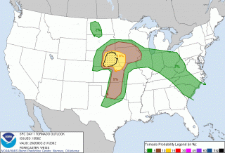
The formidable system that ground out large, violent tornadoes in Kansas, Oklahoma, and Texas on Tuesday will move east on Wednesday to bring another round of severe weather to southeast

Missouri, Illinois, and Indiana. And finally–finally!–I’m in a position to do some storm chasing. Financial constraints have majorly crimped my expeditions so far this season, but no way am I missing tomorrow.

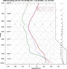
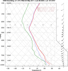
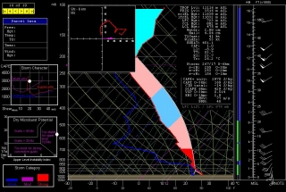
Based on Tuesday morning’s NAM run, I’d been eyeballing Effingham, Illinois, as a preliminary target for trolling the I-70 corridor. The sounding for that area looked mighty pretty, as you can plainly see.

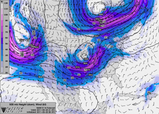
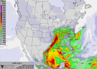
Now, however, with the 00Z runs in, I’m inclined to shift farther east near Terre Haute. Here’s another model sounding, courtesy of TwisterData, for near Oblong, Illinois. Maybe not quite as sexily backed at the surface as the Effingham sounding, but with stronger low-level winds and definitely quite functional. Maps of 500 mb winds and SBCAPE (see below) paint in a little more detail and suggest that near the Illinois/Indiana border is a good choice.

Tomorrow morning’s data will tell all. Meanwhile, it’s time for me to get my ugly-rest. I am so excited about the prospect of finally getting out and feeling the moisture, watching cumulus towers erupt and organize into glowering supercells, and hopefully videotaping some tornadoes out on the flat, wide-open Illinois prairie! A good night’s sleep and then I’m off in the morning.

Tornado Disaster in Joplin

Anything else I could write about today is overshadowed by yesterday’s horrible tragedy in Joplin, Missouri. A large, violent tornado carved a path through the heart of the city, throwing semis off of I-44, utterly destroying the hospital, and completely leveling the business section and surrounding neighborhoods.

The present death toll stands at 89. I am sure that the number of fatalities will continue to grow as rescue workers sift through the wreckage. Honor and appreciation to the numerous storm chasers who ended their chases yesterday and assisted in rescue operations and emergency medical care.

What a horrible event. Last month’s devastating outbreak across the southeast was more than enough, and now this–another large town hit by a violent wedge. It is just beyond belief, and sickening, and heartbreaking. The year 2011 will go down in weather history as the year of urban tornado disasters. My heart goes out to the people of Joplin, Missouri.

How It Feels to Not Be Chasing

Right now my buddies are out west chasing this latest storm system. I’m not with them because I can’t afford it. Money has been extremely tight and what I take in has got to go toward paying the bills and putting food on the table for Lisa and me. That’s the reality of life. I’ve been on a couple of unproductive chases so far this year, and now that a decent system is finally in play out west, I’ve got to pass it up. I can’t even chase what promises to be a fabulous day today in Illinois. Once again I’ll be picking over the scraps later on here in Michigan. It’ll be nice to get some lightning, but it just isn’t the same.

Armchair chasers are typically regarded as off on the sidelines of storm chasing. But there’s a difference when you’ve been in the game and find yourself benched. You know what you’re missing. You’ve been looking forward to it all year with intense eagerness, like a kid looks forward to Christmas. So when you can’t do a thing about it unless it lands right in your lap–which in Michigan, land of cold fronts and veered surface winds, doesn’t happen often–it is extremely frustrating. SDS is one thing, but this is something else.

Armchair chasing? Nuts. I get to where I don’t even want to go near a radar. But I do anyway. I can’t seem to help myself. I want to see what’s happening with my friends, what storms they’re on. I look at the forecast models, too, hoping against hope that they’ll stop sticking their stupid tongues out at me and smile at me for once.

Today the RUC actually seems to do so. Here’s the 10Z KGRR sounding for 23Z this evening. Not bad. I just wish I believed that those surface winds and helicities were accurate, but I don’t, not with other models (NAM, GFS, and SREF) shouting them down. Besides, the HRRR composite reflectivity hates me. I can’t stand looking at it. Again, though, as with the radar, I do anyway. Storms progged to fire in northern Illinois and even south along the Michigan border…all I’d have to do is hop in my car, head west along I-80 and maybe down toward Peoria, or even just 80 miles south down US 131 toward the state line as a compensation prize, and I’d be in the sweet zone. But it ain’t gonna happen.

Rant, rant, rant. On this date last year I was on the most unforgettable chase of my life in northern South Dakota. Today, I wish this present system would just get on with it and get it over with so I can forget about weather, forget about the fact that I call myself a storm chaser when I’m not chasing storms. What a laugh. True, I’ll be chasing this evening locally for the first time for WOOD TV8. That I can at least afford, and it’s a nice way to work with the storms that we do get and possibly provide a bit of public service. But I don’t have high expectations. That’s a good thing here in populous West Michigan, but it doesn’t satisfy a convective jones. I just hope this season doesn’t drift into the summer pattern before I can get out and see at least one good tornadic supercell.

Okay, enough of this self-indulgent, babyish whining. I just had to get it out of my system, because in all seriousness, missing out on the action bothers me a lot, an awful lot, more than I can describe. It’s an absolutely miserable feeling. But it’s how things are, and life goes on.

Good luck out there in the Plains, Bill, Tom, and Mike–and Ben and Nick, though I know you guys are chasing separately. I hope you bag some great tornadoes today and over the next few days. As for me, it’s time to shower up, head to church, and remind myself that there’s more to life than this.

Quick Summary of Wednesday’s and Thursday’s Chases

Five days and nearly 3,000 miles later, I’m back from out west. This storm system proved to be a disappointment, but it did have its moments. Bill Oosterbaan and I intercepted a nice low-topped supercell in northeast Kansas on Wednesday night, and it’s possible that we witnessed a brief tornado. I need to scrutinize the brief footage I got of the storm feature in question. What was unmistakable was the broader circulation of the storm. It seemed weird to be chasing a north-moving storm with inflow from the northeast, but that’s how it was with storms that moved along a warm front–apparently across it–near a low center with a 500 mb closed low in the vicinity.

Yesterday was a more typical setup. We targeted the Muskogee, Oklahoma, area, which the SREF and RUC pointed to as offering the best overlay of instability and mid-level support, with the H5 jet core nosing into the region.

We were right on the first storms as they initiated, but they were feeble things that just couldn’t seem to get their acts together. With a long drive home lying ahead of us, we concluded to start heading north and settle for a nice lightning show on the way home.

But our prospects improved as the 500 mb jet began to strengthen. A couple of cells to our west and northwest intensified and began to take on a telltale appearance on the radar. A handful of scans later, rotation started to manifest on SRV. By this time we were on US 59 north of the Grand Lake of the Cherokee, east of Vinita and directly in the path of the southernmost cell. At a side road, we pulled aside and I tripoded my camcorder and videotaped some nice storm features: pronounced beaver tail, tail cloud, a nasty-looking wall cloud, and a wet RFD notch.

Beginning as a classic supercell, the storm looked for a while like a tornado breeder. But after predictably morphing into an HP, it eventually lined out and got absorbed into the wad of convection springing up to its south. Lack of adequate helicity is probably what kept this and other storms non-tornadic. METARs showed backed surface winds in the vicinity of the storms, but from what I observed, surface inflow was non-existent to weak. Hodograph curvature doesn’t matter much if boundary layer wind speeds are puny.

I have a few photos to process that I’ll slap up in a day or two, possibly along with a radar grab or two. Right now, though, I’ve got some work I need to accomplish before the work week ends, so here’s where I sign off.