May 28, 2013, Tornadic Supercell by Grand Ledge, Michigan

Tornado season is now long past, and the sting of missing great storms either through bad targeting or having to head home one and two days before two major events has eased. Maybe next year will be better. Besides, the show’s not over till the snows fly.

Meanwhile, I’m looking back to my most interesting chase of the year, documented by the video at the bottom of this post. Ironically, I logged around 6,000 miles to and from Oklahoma and Kansas with little to show for it, while my humble backyard of Michigan gave me an enjoyable and productive bit of action.

On May 28, a warm front lifted up through lower Michigan, ushering in decent moisture and instability along with a good boundary for them to work their mojo with. The thing that seemed to be missing was adequate shear for storm organization–but I ignored conditions farther east of me. I just didn’t take the setup seriously enough, and when Kyle Underwood, the WOOD TV8 meteorologist, inquired which of the TV8 chasers planned to head out, I said that I didn’t see much potential. If something came my way, I would grab it, but otherwise, I didn’t want to waste gas. That was understandable: money was tight, and I planned to chase in Kansas the next day. Still, geeze, what an idiot (me, not Kyle).

Let us pause momentarily while I give myself a retroactive dope slap. I have come to a conclusion: in Michigan, when a warm front shows up with good CAPE present and any kind of bulk shear to speak of, even anemic bulk shear, chase the front. Never mind what the models have to say about storm-relative helicity; helicity will take care of itself if a storm manages to organize in the vicinity of the frontal boundary. Just get out there and chase the stupid front. Particularly farther to the east. Storms in Michigan often have a way of intensifying and organizing near and east of I-69 and, north of Lansing, US-127.

That was the case on this day. My first clue was when I glanced at the radar later and noticed that Kurt Hulst was on a storm off to the southeast. Kurt knows what he’s doing, and the storm looked decent–in fact, it was tornado-warned. Okay, I thought, I missed that one. Probably it’ll be the only one. So I sat tight and watched the radar as other storms formed. They looked like a convective mess to my west, but they clearly were moving into a better environment as they progressed east. Finally, I’d had enough. I grabbed my laptop and cameras and headed out.

I locked onto the most intense-looking cell in my vicinity and tracked with it toward Portland. But another was following on its heels, and given the way that the storms were behaving, I thought I’d be better off dropping the one I was on and letting the new one come to me. Presumably, it would get its crap together on the way, and that is what happened.

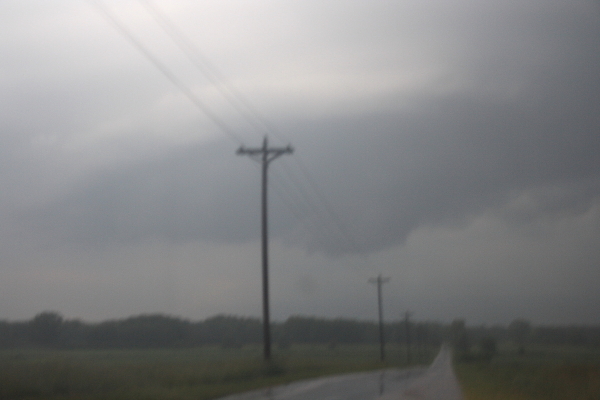
As it approached Grand Ledge just west of Lansing, this storm developed a most amazing streamer of scud sucking into its updraft base from the east. It appeared to originate near ground level–hard to tell with trees constantly interrupting the view–and rocketed toward the storm, leaving no doubt that this storm had impressive inflow.

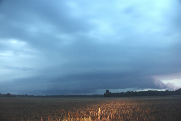
Driving into Grand Ledge, I found myself under the area of rotation, with crazy, low cloud motions. Turning around, I headed back north and parked by the airport, then watched and filmed as the storm headed east into Lansing. It looked very close to spinning up a tornado; in the video, you can see it trying hard, and eventually it succeeded.

But I had to drop the chase. My friend Steve Barclift and I planned to chase the next day in Kansas, and I had to meet him so we could hit the road for the long drive west. As it turned out, the storm I was on provided a better show than anything we saw along the dryline. My buddy Rob Forry managed to catch this storm at its tornadic phase and got some nice video.

My original hi-def shows the motion of the inflow streamer nicely as I enter Grand Ledge. Regrettable, this YouTube clip doesn’t render the details as well, but you’ll at least get a feel for the motion. The storm was an interesting one and fun to chase. It would be nice to get another one like it. It’s only August, so the door is far from closed.

Remember When . . . ?

Remember when tornado photos were all black-and-white, and you only saw them in the newspapers?

Remember how rare it was  to see them?

Remember newspapers?

Remember watching The Wizard of Oz every time it played on TV, and never missing a showing, just so you could watch the tornado scene? (“It’s a twister! It’s a twister!”)

Remember how fascinated and delighted you were when they showed those grainy old movies of tornadoes in school, or sometimes on TV, and how you wished they’d replay them and then replay them again so you could watch them over and over and over?

Remember when you first saw that incredible photo of twin funnels south of Elkhart, Indiana, taken by photographer Paul Huffman during the 1965 Palm Sunday Outbreak? And that dramatic image of the Xenia, Ohio, tornado shot at just a quarter-mile away from Greene Memorial Hospital during the 1974 Super Outbreak?

Remember your first successful chase? (As if you could ever forget.)

I remember mine. It was in August 1996 across central Michigan, roughly along the M-21 corridor. North of Saint Johns, Michigan, I watched as a beautiful tube dropped from a classic supercell that was as sweetly structured as anything I’ve seen on the Plains. Both the tornado and its parent storm were gorgeous–and I was elated.

Remember when there were no laptops, no Android phones, no mobile data, no GR3–just your car, your weather radio, maybe a tiny portable TV, and a ton of hopefulness and excitement as you drove happily down the highway toward a sky full of rising towers?

Remember when seeing a tornado was rare and busting was something you simply expected and took in stride as part of paying your dues?

Remember before the movie Twister came out?

Remember before the Stormchasers series?

Remember when storm chasing wasn’t “extreme”?

Remember when storm chasing barely was at all?

Remember when Storm Track was a print newsletter published by pioneer chaser David Hoadley? I regret that I never subscribed, because I could have learned much from it.

Remember when the online version was a resource everyone welcomed and loved, not a point of contention among some chasers? I’m so glad the worst of that scuffle is a few years behind us now.

Remember when there was no live stream to fuss with, no competing with a league of other chasers all getting similar footage of the same storm, and no rush to process your video and get it to the networks first? (Not that I would know about that last point personally. I’ve never gotten the hang of it and don’t particularly care.)

Remember when there was nothing to prove, no reputation to make or uphold, and no stripes to earn?

Remember when it was just about the storms, period?

Don’t you wish it still could be?

Why can’t it?

Remember how excited you were when you first got hooked up with a laptop, GR3, and mobile data?

Remember how, before then, you used to stop at airports and small-town libraries just to get a glimpse of the radar?

Remember when there was no TwisterData, no HRRR, no SPC mesoanalysis graphics, no easy way to obtain forecast soundings, no abundance of forecasting resources available at just the click of a mouse button?

Remember when you weren’t even aware that there were forecasting resources available to you?

Remember your first exposure to the SPC forecast discussions, reading through all that arcane gobbledegook and thinking, “These people speak Martian”?

And then thinking, “Maybe if I just head for the center of where it says ‘Moderate Risk’ . . .”?

Remember discovering COD and looking over their forecast maps and not having a clue what they meant or how to use them? You pulled up the 500 mb heights/wind map and admired the pretty colors and thought, “This looks like it could mean something.”

Remember not knowing the difference between GFS and ETA and RUC?

Remember ETA and RUC?

Remember knowing absolutely nothing about forecasting, and how you struggled to learn, and how thrilled you felt when you finally pieced things together and successfully picked a target, or at least had your forecast verify?

Remember all that?

Never forget.

Many of you are too young to have experienced some of the things I’ve mentioned. You missed out on something good. It doesn’t all sound good, I’ll grant you–no in-car radar, no access to a bazillion free online weather resources–but it had its virtues. Not that I’d care to go back to caveman days, but I’d love to reclaim their spirit.

The beat goes on, and those of you who boarded the bus farther down the road are building your own list of remember-whens. But we who are in our mid-forties and older can recall simpler times. They were far less technically advanced, but they were also infinitely less frantic and driven overall. I guess you have to reach at least fifty years of age before you get to say stuff like that. It’s the province and privilege of duffers. I qualify, and I’m okay with that.

I wish I could claim something akin to the number and quality of tornadic encounters, and the knowledge gained thereby, and the photos to show and the stories to tell, possessed by some of the luminaries who are my age or not all that terribly much older. Those guys have got a lot to remember! But what’s mine is mine, and it’s enough to reminisce upon. If you got your start when storm chasing was of a different character than it is today, you know that you were privileged to come up in a special time, a time that can never be reclaimed. And memories of those days are well worth treasuring and reflecting on and feeling grateful for the experiences that created them.


Missing Out on Moore

I haven’t posted in this blog for several weeks. Behind my lack of motivation lies a depression over how this storm season has turned out for me, which reflects a broader sense of personal failure as a storm chaser. A melancholy lead-in such as this will probably lose some of you, and I understand. It’s not exactly sunshine and a bowl of Cheerios. But others may identify with this post and perhaps even find it helpful, and in any case, it’s my blog, and I’ll write what I please.

The May 20 Moore tornado exacerbated what has been a brooding issue for me since 2011. During that intensely active and historic year, I was sidelined from chasing due to family and financial constraints, and my final shot at a decent chase on June 20 in Nebraska failed by an hour due to a series of delays along the way. With last year’s notable exceptions of the March 2 Henryville, Indiana, tornado, and April 24 in Kansas, the trend has continued. And given how this year’s slow start finally exploded in the second half of May with storms that ranged from photogenic to disastrous, coming home empty-handed from my two brief excursions to the Great Plains during another historic year has been hard to take.

This post, then, is a continuation of my processing a deadly storm season that has robbed the storm chasing community of some of its best and brightest, exacted a steep toll on the residents of Oklahoma City, afforded a flood of spectacular videos, and caused me to search my soul as a storm chaser and wonder whether I even qualify as one.

The rest of what follows is a post I wrote earlier today in Stormtrack. It belongs in this blog too, even moreso than in the chaser forum.

————————————

Missing the Moore tornado in particular touched something off in me. I’ve never felt more frustrated about missing an event I would never have wanted to witness.

El Reno didn’t have that same effect on me. I watched the whole scenario unfold on the radar and on KFOR live stream with horror, not with regret that I was missing out on anything, and my sense of it is that OKC got off very lightly. I’m probably better off for not having been there. It was too dangerous a storm.

But missing Moore was a bitter pill to swallow, and I think a lot of the reason has to do with my limited ability to chase. I just can’t afford to do it nearly as often or extensively as I’d like, so having to head back to Michigan empty-handed one day too soon after driving all those miles, knowing that the next day would be big in Oklahoma, was hard on me. I could have afforded the extra day and I badly wanted to stay, but one of the guys had to work the following morning, and there was no getting out of it. He had a responsibility to his employer and his family, and as the driver, I had a responsibility to him. Such responsibilities are honorable and will always come first with me.

But that didn’t make things any easier. Watching the debris ball roll across Moore on GR3 while I was driving east through Missouri created an ugly mix of feelings for me. My first thought was, Oh my God! When you see something like that, you just know something horrible is happening.

My second thought was, I’m missing it. After driving all those miles and busting (got just a fleeting glimpse of a rope tornado, not anything to even talk about), that radar image seemed like a slap in the face. I felt angry, like I’d been robbed, betrayed. Which is crazy, of course, but feelings are feelings, no more and no less, and I’m just being honest here about mine at the time.

My third thought, which is the one I’ve had to wrestle with since, was, Why? Why was I feeling so torn about missing something so terrible, an event that would have have broken my heart and caused me to lose sleep if I had been there? I don’t think there’s a simple answer; I think there are many components which add up. But the bottom line is, there’s an obsessive aspect to chasing for me that can either make or ruin my day and even my week. I don’t see that as healthy, and it didn’t use to be that way. I use to take my limitations in stride, and busts were just busts: not personal failures, just part of paying my dues as a chaser.

But chasing today is a whole different ballgame than it was when I first got started seventeen years ago. The mindset is more competitive, many more people are doing it and spending gobs of cash and time in the process, and overall I just can’t keep pace with it. So I’ve had to–and still have to–do some soul-searching. Who I am as a person goes far deeper than chasing storms. And more important to me than being in the mainstream of chasing is having peace of mind, and that requires accepting my limitations, working within them to simply enjoy something I love to do without letting it own me. I find that much easier to say than it is to do, but for me it is a necessity. If I can afford to chase a setup, I will; if I can’t, I’ll wish those of you who can success–and safety. I hope it will be many, many more years before anything like another Moore or El Reno occurs.

June 12 Chase in Northwest Indiana and Michigan

There’s nothing fancy about these pics. They are what they are. But after a tremendously frustrating May–a rant I won’t even bother to get into right now–it is nice to have at least something to show.

The setup was a warm front strung from Iowa eastward across northern Indiana, typical of the south-central Great Lakes region. While the NWS was talking of a derecho, forecast soundings a couple days in advance seemed to point to tornadic potential. And indeed, on the day-of, the SPC issued a high risk across the area, with a 10 percent hatched tornado risk in the area where Kurt Hulst and I chased and a 15 percent hatch farther to the west.

6122013 Meso NW INThe photos show what we came up with in northwest Indiana south of Koontz Lake. The first blurry shot is of a small mesocyclone on a storm which, on the radar, gave only small hints that it could harbor one. Sometimes, given the right environment, what base reflectivity renders as amorphous blobs can provide surprises where you find a little sorta-kinda-almost hooky-looking little notch, and that was the case here.

For a minute, it actually looked like it might give us a tornado, but the lack of surface winds was a good clue that wasn’t gonna happen. Structurally, though, this little storm offered an interesting opportunity to try and read clues in the clouds as to what it was doing or planned to do. I’m not sure I ever did figure that out, but it was fun to watch.

6122013 Meso S of Koontz Lake INAfter watching it for several minutes, we dropped it to intercept the larger, more robust cell advancing behind it. This storm had displayed prolonged rotation on radar, and as we repositioned near a broad stretch of field that gave us a good view, we could see a stubby tail cloud feeding into a large, flange-shaped meso. The storm was clearly HP, with a linear look to it that suggests a shelf cloud, but there was no mistaking the broad rotary motion, and you can make out some inflow bands in the picture. At one point, a well-defined funnel formed just north of the juncture with the tail cloud (or whatever you want to call it) and the  rain core, drifting behind the core and into obscurity.

We played tag with this storm for a while, but it was toward sunset and getting darker and darker, and eventually we decided to call it quits and head back. The storms where we were just lacked the low-level helicity to go tornadic. There was ample surface-based CAPE–somewhere in the order of 3,000 J/kg, methinks– but whatever inflow was feeding them appeared to be streaming in above ground level.

So we headed back into Michigan, and as we drove north on US-31 near Saint Joseph, things got interesting fast. Green and orange power flashes suggested that a high wind was moving through nearby. A glance at the radar and, sure enough, there it was: a bow echo. It didn’t look terribly dramatic on radar, but looks can be deceiving.

Heading east on I-94, we attempted to catch up with the belly of the bow as it rocketed toward Paw Paw and Kalamazoo. The next fifty or sixty miles was a millrace of frequently shifting high winds and torrential rain punctuated by power flashes. At one point, we narrowly missed running into a highway sign that blew across the road in front of us. At another, we passed an inferno where a falling tree had evidently gotten entangled in a power line.

North of us on the radar, we could see a supercell moving over the town of Wayland. But it was a little ways beyond reach, particularly given the kind of backwoods territory that lay to its east.

The high winds and driving rain ended, ironically, as we entered Kent County. My little hometown of Caledonia got just a relative dusting of rain and maybe a zephyr of outflow. It was hard to believe how much drama was playing out just a few miles to the south.

Big thanks to Kurt for taking me out with him when I didn’t have the gas or the money to chase on my own. I needed to get out and chase, and the sneering irony of having a robust setup dropped in my backyard and not being able to do anything about it was really eating me yesterday. I got to go out after all, and it felt wonderful.


Why I Chase Storms: A Storm Chaser’s Manifesto

I posted the following message on Facebook, but it really belongs here. It is one of what I think will be a number of very personal, reflective posts on storm chasing as I process the impact of a difficult, disappointing, terrible, and tragic season.

——————————

This storm season has left me feeling very torn. As I sift through its impact on me, I am grateful for my friends who are NOT chasers. People whose perspective on life is different from mine. My men’s group, for instance, is a small circle of wonderful, godly brothers in Christ who have seen plenty of life. It felt cathartic to share with them last night about my passion for chasing storms, my sense of failure as a chaser, and the recent, tragic losses of Tim and Paul Samaras and Carl Young.

In talking with the guys about chasing, I spoke frankly about a common misconception about storm chasers: that we are out there saving lives by what we do. That may sometimes be the case, but it is not the motivating force for me or any of the chasers I know. That image, fostered by the media, simply isn’t what drives chasers. I chase, and most other chasers chase, primarily because we are enamored with the storms. There is nothing intrinsically heroic in what we do. Depending on where we’re chasing, our presence in the field can be valuable as part–and only a part–of warning the public. A few chasers–a very few, including the late Tim Samaras–collect data for scientific research, some of which could conceivably help to improve an already excellent warning system. Occasionally, some chasers find themselves in a position to make a life-saving difference as first responders. And Storm Assist is providing a fabulous means for chasers to contribute their videos to a charitable cause whose proceeds go directly to aiding the victims of tornadoes and severe weather.

All of these things are true and good. But they’re different from the myths that have arisen around storm chasing. One of those myths is that chasers are sickos who enjoy watching homes and communities get trashed; the other is that we’re more noble than we really are. Between these two extremes lies the reality of why storm chasers actually chase. And the truth is, no single reason fully describes every chaser. Chasers are individuals, and today as never before, that individual component interacts with the influence of technology and the media to create a complex and varied mix of motives.

Yet I believe all chasers possess one common denominator: a love for, a passion for, the storms. Personally, storm chasing engages me on many levels–intellectual, emotional, spiritual, aesthetic, creative, and adventurous–in a way that nothing else does. When I can chase the way I want to, I feel alive; when I cannot, which is far too often, I feel intensely frustrated, moreso than I think is healthy. Lately, my limitations have left me feeling depressed. That is something I have to work through, talk to God about, and discuss with those close to me who know me well.

But one thing is certain: I chase, as best I am able, because it is what I love to do, period. There is nothing else like storm chasing. I love the sky, the storms, their drama and beauty, their intensity, their mind-boggling motion, the awe they inspire, the landscapes they traverse, and the lessons they have to teach. I am a pupil of the atmosphere.

Because I live in a part of the country where both tornadoes and experienced chasers are far fewer than in the Great Plains, I can perhaps play a more significant role locally in helping to warn the public than in Tornado Alley, where droves of chasers line the roads. Chasing for WOOD TV8 here in West Michigan creates that possibility for me.

But I would chase regardless. It’s what I do, just as playing the saxophone is what I do and just as golfing, or car racing, or writing, or painting, or fishing, or crocheting, or hiking, or hunting, or what have you, is what you do. We’re all wired to do something, and we desire to do it excellently. There’s nothing innately noble about it, and there doesn’t need to be. Your pursuit may, in the right circumstances, put you in a position to contribute to the well-being of others. But it needs no justification in order to be worthwhile.

That is how I view storm chasing, and I think many of my fellow chasers would agree.

So please do not thank me for what it is I do, for the only thing I am doing is following my heart. In the same breath, please do not condemn me for it, for you may benefit from it someday–again, as just one facet of an excellent warning system in which I play only a part.

The Deaths of Tim Samaras, Paul Samaras, and Carl Young

When last I wrote about this year’s storm season, it was non-existent: a cold, cold April and early May with teaser setups shot to pieces by crashing cold fronts.

Funny how fast things can change–or really, not so funny. No, not so funny at all.

On May 20, non-existent turned into horrible when an EF-5 tornado ripped across the heart of Moore, Oklahoma, killing 24 people. Then, as if that weren’t bad enough, on May 31 a monstrous supercell with multiple rotations took a second swipe at the area, taking another 11 lives (at last count). I followed its progress on radar, and I don’t recall ever seeing anything like it before: just one big, amoeba-like mass of churning vortices pulverizing an already storm-shattered city. KFOR chopter cameras showed a rain-wrapped tornado approaching a highway filled with several miles of gleaming headlights, all at a standstill–hundreds of panicky motorists trapped as a mass evacuation turned into a parking lot. It was unbelievable. And it was horrifying.

I have written nothing about storm chasing for over a month. At first, it was because there was nothing to write about. Then came the Moore tornado, and after that I’ve had just the opposite problem. I have felt overwhelmed with conflicting emotions, and there is so much to say that I haven’t known where to begin.

Until now. Tonight, I can no longer keep silent. I must write.

When news of the deaths of veteran storm chaser and tornado research luminary Tim Samaras, his son Paul, and his chase partner Carl Young began to filter in last night on Facebook, I took it with the usual grain of salt. These things have a way of proving false, and I take a dim view of sensationalist reports until the facts have been confirmed.

In this case, sadly, they have been. Three bright stars in the storm chasing firmament have fallen from the sky. They were not the idiot yahoos everyone expected would one day become storm chasing’s first direct tornado casualties. They were skilled chasers, as expert and knowledgeable as they come and known for their caution and respect for the storms. Whatever circumstances surrounded their deaths in the violent El Reno tornado, it is doubtful that they involved deliberately foolish risk-taking. That wasn’t their style.

I have never met Tim, Paul, or Carl, but many chasers have, and everyone knows of Tim’s work. Simply put, he was one of the most respected names in the field of storm chasing, and from everything I have heard, one of the nicest. I have never heard anything but good words for all three of these guys. And now they are gone, torn from our midst far too soon.

There is some consolation in knowing that these men died doing what they loved. Some. But it does not mitigate the grief felt by their families and friends. Even those such as I who did not know them feel a great sadness. My heart is heavy, and my prayers are with the loved ones of Tim and Paul Samaras and Carl Young.

May you rest in peace, gentlemen. You have given the world much. Thank you.

Are the Great Plains About to Open for Business?

ECMF-GFS H5 fcst 0408013Last year’s abnormally balmy March opened for storm chasers with a lion-like roar on the 2nd with a deadly outbreak of tornadoes along the Ohio River southward. But from then on, with the exception of April 13 and 14, the season dwindled into a pathetic, lamb-like bleat.

This March has been the polar opposite, and I do mean polar. Many chasers have been champing at the bit due to a wintry pattern that has simply refused to let go. But that may finally be about to change, and April may be the month when this year’s chase season starts to howl. For the last several days, I’ve been eyeballing a large trough on the GFS that wants to invade the Great Plains around April 8, shuttling in Gulf moisture and also suggesting the possibility of warm-front action farther east on the 9th.

GFS H5 fcst 00z 040913The ECMWF broadly agrees. The first map (click to enlarge), initialized today at 00Z, compares the 168 hour forecasts for GFS and Euro heights for Sunday evening, April 7 (00Z April 8). The second map, from TwisterData, depicts the GFS 24 hours later at 7 p.m. CST.

Maybe not a poster child for negative tilting (though the 6Z run changes that), but it could signal the breaking of the Champagne bottle against the hull of chase season 2013. The details will fill themselves in as the forecast hour narrows down. Right now, this is a hopeful sign for storm chasers. Winter may still have a gasp or two left, but we’ve made it through, and change is on the way.

Prior to that, the models point to a shortwave moving through the upper Midwest next weekend. Will it have sufficient moisture and instability to work with near the warm front? Good question; we’ll find out, assuming subsequent model runs don’t wash it out. So far it has shown up consistently. For those of us who live northeast of Tornado Alley, it’s worth keeping an eye on.


The Foibles of Long-Range Forecast Models

Tues_March_19_GFS300hrsSometimes a picture really is worth a whole lot of words. In this case, two tell the story more eloquently than I can.

In the image to your left, the 12Z run of the  GFS depicts 500 mb height contours, surface moisture, and surface winds at 300 hours out, or twelve days before the forecast date.

The second image, taken just a little while ago, shows the same information for the same system, only now we’re down to just 66 hours from forecast time. Note that the forecast date has moved up a day to Monday; by Tuesday, the whole system has moved off to the east and out to sea. Bye-bye moisture and instability.

Mon_March_18_GFS66hrsWhat happened? The GFS happened, that’s what.

I realize that for many of my storm chasing readers, maybe most of you, I’m preaching to the choir, but some may wish to take note of the following:

Long-range forecast models are notoriously undependable and prone to change.

If you’ve never heard the colloquialism wish-casting, now’s the time to add it to your storm chasing lexicon. The further out you go beyond three days from an event, the more that attempting to forecast a chaseable setup amounts to just a hope and a prayer. Bad data and changing data amplify progressively in the numerical models, to the point where what you see at 240 hours out is subject to anything from mild to wild fluctuation and revision as the forecast hour draws closer and new data gets processed. By the time the NAM and SREF lean in, and finally the RAP and HRRR, what you see may resemble nothing like the deep, negatively tilted trough and gorgeous moisture plume that first captured your attention. The shape, the timing, wind speed and direction at different heights, quality of moisture, instability–everything can change, and it will, possibly quite drastically.

Remember the gossip chain? Anna tells Peter, “Selena just bought a used Nissan from the same car dealer where Jaden bought his truck. It’s on 44th Street about a mile from the dump.” Peter passes the news on to Sam thus: “Selena just bought a car from the same dealer where Jaden got his truck next to the 44th Street dump.” Sam tells Chelsea, and Chelsea tells Adam, and so it goes, with the information getting nuanced a little more each time until it becomes outright twisted. Finally, word gets back to Selena: “Hey, Selena, what’s this I hear about you buying the dump over on 44th Street from some drug dealer?”

It can be kind of that way with long-range forecasts.

So why even bother watching the long-range models, particularly the famously untrustworthy GFS? There are two reasons. One is, the models can provide a heads-up to the possibility of a chaseworthy setup. At 192 hours out, don’t think of the models as forecasts–think of them as potential forecasts, something to keep an eye on. A given scenario could fall completely apart and often does. But it could also develop run-to-run consistency that agrees with the short-range models as they enter the picture, and ultimately lead to a decent chase.

For those of us who have to drive a long distance to Tornado Alley, such advance awareness is particularly valuable. If you live in Chickasha, Oklahoma, or Wichita, Kansas, you can roll out of bed in the morning, look at the satellite, surface obs, NAM, and RAP, and decide whether you’re going to chase in the afternoon. But if you live in Grand Rapids, Michigan, or Punxatawney, Pennsylvania, things aren’t that easy. When you’ve got to travel 800 to 1,000 miles or more to get to the action, burning time and fuel and perhaps vacation days, lead-time becomes important, and the more, the better.

The second reason for watching the long-range models is sheer obsessiveness. Call it desperation if you wish. It has been a long winter and storm chasers are itching to hit the road. Some of us just can’t help ourselves–we want to see some flicker of life, some sign of hope, some indication of the Gulf conveyor opening for business beneath a warming sun and dangerous dynamics. What’s the harm in that? Most of us know enough not to hang our hats on a 120-hour forecast, let alone one that’s two weeks out. But it doesn’t hurt to dream. After all, sometimes dreams come true.

Remembering the Henryville EF4 Tornado: A One-Year Retrospective

We were three-and-a-half miles north of Palmyra, Indiana, when the tornado crossed the road less than a mile in front of us at Dutch Creek Road, ripping up a 12 x 12-foot section of asphalt in the process and throwing it in chunks into an adjacent field. Within about a minute, the vortex had morphed from a wispy rope into a powerhouse of a stovepipe, tearing tangentially across our path as Bill Oosterbaan and I blasted north on State Road 135.

Bill is no timid driver, and he did a heck of a job keeping pace with the beast. But the storm was a missile, moving at least 60 miles an hour, and once we hit downed power lines at Dutch Creek Road, we had to let it go. We had no idea of the tragedy it was about to inflict to our northeast. But, watching the white condensation funnel billow and intensify beyond the treeline, with secondary vortices wrapping around it like a cloak, we could tell it was a monster. As I filed a report on Spotter Network, Bill turned around and headed back south. A second supercell was hot on the heels of the one we had just let go, and repositioning became our immediate concern.

Bill and I had just been fortunate to catch and videotape the Henryille EF4 tornado in its formative stages. We first glimpsed it south of Palmyra as it descended from a wall cloud several miles to our west-northwest. It didn’t look particularly impressive at that point, but as we closed in, the fast-moving circulation began to display wild shapes and motions, then condensed fully and finally just before crossing the highway.

It seems incredible that  in the few meager seconds the tornado took to translate across SR 135, it managed to rip up a large section of road. The term “asphalt scouring” just doesn’t apply; there was no scouring involved. An estimated 10,000 pounds of pavement got literally torn from the downwind side of the highway and thrown something like one hundred feet. I didn’t witness this road damage and only found out about it later. But chaser Simon Brewer provides a good description of what he saw just a few-score yards north of where Bill and I turned around.

The wider damage path associated with the main tornado circulation was easily visible from a forest west of the highway through a field, and past the highway through another forest to the east. Also, an individual suction vortex damage path was easily found starting in the field scouring vegetation and tossing boulders from a drainage ditch, then crossing a section of highway peeling and tossing massive slabs of asphalt, the largest broke upon second contact with the ground (it bounced leaving an significant impact crater) on the downwind side of the highway. Typical sphalt scouring is usually associated with EF3 and stronger tornadoes, but typical asphalt scouring is found on rural roads with relatively thin asphalt 1-2 inches or less thick. It’s amazing to think how short a time period the small suction vortex was probably over that section of highway; maybe only a second tops! I usually don’t stop to investigate tornado damage, but when I saw the highway damage on March 2nd I was blown away! I took more photos of the road damage than I did the storm and tornado. I consulted Dr. Greg Forbes and he agreed this was one of the most incredible damage cases he’s heard, only possibly being eclipsed by the trench created by the Philadelphia MS EF5 on April 27, 2011.*

A year has passed since all of the above took place. At the same time last year as I am presently writing these words, Bill and I were nearing Louisville, and within another hour or so we would shift into chase mode, head west, and intercept our storm. Click here to read my complete account of that chase, including my video of the tornado as well as radar images and skew-Ts.

Today the weather is drastically different. This March is behaving like March, not May, and in light of last year’s prolonged heat wave and disastrous drought, I am glad. I will be delighted to see another round or two of good winter weather bring still more moisture to the Plains and Midwest and prime the pump for storm season. The storms of spring will get here soon enough, and while nothing is certain, my hunch is that this year will be better than last year.

_______________

* Simon Brewer, from his January 14, 2013, post in the Stormtrack thread The EF Scale and Asphalt Scouring Caused by the March 2 Henryville Tornado. Also see Simon’s and Jim Bishop’s chase account, which includes photos of the road damage, at their Stormgasm website. You can see Dutch Creek Road just past the road sign and parked car in the background of the first photo.

Enter March: No Repeat of 2012

March 2 2013 GFSMarch 2013 won’t be making anything like last year’s brutal grand entry. For residents of the Ohio valley, that is a good thing. On March 2 a year ago, unseasonably springlike conditions fostered an outbreak of tornadoes, including the violent Henryville, Indiana, tornado that my friend Bill Oosterbaan and I intercepted north of Palmyra.

This March’s arrival portends nothing like that. One look at the map (click to enlarge) will show you that conditions are quite different from last year. The model is today’s (February 27, 2013) 00Z run showing the 500 mb heights and surface temperatures for March 2 at 21Z. With a ridge dominating the western half of the CONUS and cold Canadian air sitting atop the Great Lakes, the picture doesn’t even remotely resemble the 2012 scenario that sent storm chasers scrambling for their gear. A few days prior to the event–that is, right about now–we were casting anxious eyes on the embryonic system with the sense that northern Dixie Alley was in for it.

I’m frankly glad that a cooler, more quiescent opener is in store for the 2013 meteorological spring. I will be pleased to get more snow, and I hope the Midwest and Great Plains get a few more good, solid dumpings before storm season arrives in earnest. Storm chasing aside, the more moisture, the better for regions that have languished under severe drought. As inconvenient as the recent blizzard was for west Texas, I’ll bet the folks in Amarillo were mighty glad to get that much snow. I hope they get more, or just water in abundance in whatever form it takes.

This March may be entering on the cold side, at least here in Michigan, but that’s okay. It is March, the month of transition. I’m equipped with a “new” used car, a 2002 Toyota Camry that is drum tight and ready to take me wherever I need to go in order to see tornadoes. It won’t be long now. See y’all under the meso!