The Summer Pattern Is Setting In

The SPC has placed Michigan and the Great Lakes in a slight risk area for tomorrow. But tornadoes aren’t in the picture. The summer pattern appears to be setting in, with the jet stream moving its headquarters to the US/Canadian border. As far as Michigan is concerned, that’s close enough that we can still expect some decent kinematics here and there. But what we get tends to result in linear MCSs more than supercells and the like.

Tomorrow’s SBCAPE should settle in between 2,500 and 3,000 j/kg, with dewpoints in the 70s. That’s certainly an ample supply of convective fuel. And F5 Data shows this for H5 wind speeds at 21Z:

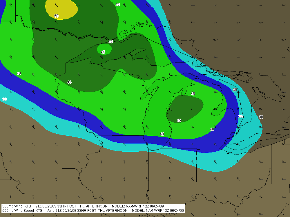
If you can live with northwest flow, that’s not bad. But of course, the underlying winds are all westerly. Once again, Michigan’s energy will get sabotaged by unidirectional winds. How pathetically par for the course! Maybe we’ll get some supercells, but we’re unlikely to see the low-level helicity needed to make them tornado producers. Probably better knock on wood when I say that, because the lake breeze zone can do some funny things with locally backed winds. Overall, though, I think the order of the day will be some nice, burly, ouflowish thunderstorms.

What do I know, though? I’m still pretty green as a forecaster, and I recall a couple years ago when the models showed a unidirectional setup with nothing in the way of helicities, and an F3 tornado ripped through Potterville.

One of the nice things about living in Michigan this time of year–among the many wonderful advantages of this beautiful state–is that we’re prone to get a couple supercellular events when the traditional Tornado Alley of the Great Plains simmers under a titanium cap. Those occasions aren’t anything you can count on, but it’s nice when they happen–for me and my fellow storm chasers, anyway. I suppose other folks here might see things a bit differently.

The Loudest Sax Player Ever

My friend and fellow musician Dave DeVos once told me, “You are the loudest sax player I’ve ever known.”

His words weren’t a compliment, just a statement of fact tinged with a slight mix of incredulity and annoyance. I’m a very loud sax player, much louder than I realize. As the old cliche says, I don’t know my own strength.

Of course I can play softly, but soft is not my default mode. Part of that is attributable to my horn, which is an old Conn 6M “Ladyface” that is very good at translating the air I move through it into immense volume levels. Another part is due to my mouthpiece, a Jody Jazz classic #8. But I think the main reason I’m a loud player is directly linked to the guy behind the horn. I just seem to have a knack for massive sound output.

I wasn’t always a loud player. I entered my freshman year in college a quiet young saxophonist. My sound at the time was styled after Tom Strang, a local alto man who owned a jazz bar in Ada called the Foxhead Inn. Tom had a smooth, mellow sound, very pleasing to the ears. He was not a loud sax player.

As an early influence, Tom’s tone pointed me toward a somewhat Desmondesque approach, not exactly the kind of robust Cannonball sound that could melt the wax in a listener’s ears at 100 feet. It was more a kind of foofy-foof-foof tone–subdued and, I thought, pleasantly sophisticated.

It was this mellow, sedate sound that I brought with me to the student big band at Aquinas College, where I sat under the august directorship of jazz professor Bruce Early. I was assigned to the first alto chair, and my lack of experience was such that I felt eminently qualified to fill the position. Clearly word of my abilities on the sax had preceded me, and Bruce had simply placed me where he knew I belonged. First chair. It was inevitable.

I’ll never forget my first awakening to the possibility that maybe I wasn’t all that and a supersized order of fries. The band was playing through some tune I’ve long since forgotten, and in the middle of the chart there was space for an alto solo. Cool. A chance for me to show my stuff, give Bruce a taste of my chops. I launched into the solo. Foofy-foof-foof, I played, subtly, while the rhythm section whanged away.

Bruce stared at me. “Play louder,” he said.

Ah. Louder. Okay then. Foof-foof-foofy-foof! I declared, in a volume that could almost be heard from ten feet away.

Bruce’s stare became a glare. “Louder!” he barked.

My gosh, what did this guy want? Here I was, foofing as loudly as ever I had foofed, and Bruce was calling for more.

I returned his glare with a desperate glance.

Foof? I played. Foofy-foof!

I was trying, but I quickly trended toward the softer, cocktail lounge volume that I was used to.

That did it for Bruce. “BLOW!!!!” he yelled. “For crying out loud, BLOOOWWWWW!!!!!!”

Some of the more seasoned musicians snickered, and my face went red as a beet. Hell’s bells. Fine, if it was volume Bruce wanted, I’d give him volume. And I did. I had a lot to learn about embouchure and tone production, but at that point I instinctively dipped into the raw essentials, filled my lungs with air, and blew my ever-loving cheeks off.

From that time on, while Bruce yelled at me for any number of things, my volume level wasn’t among them. He never again complained that I was playing too softly. Nor has anyone else, for that matter. Not ever. I’ve played with highly amplified blues bands and church worship teams and outblown them without using a microphone. I’ve been asked plenty of times to turn it down a bit, please. But no one has ever come to me and said, “Could you play louder? I can barely hear you.”

Just ask Dave. He’ll be glad to tell you, as soon as his ears stop ringing.

June 19 Central Illinois and Indiana Storm Chase

Approaching our storm from the north near Normal, Illinois.

Approaching the storm of the day south of Normal, Illinois.

After Iowa’s blue-sky bust on June 18, yesterday provided some welcome and much-needed activity. Between illness and May’s ridge of steel, my chase expeditions this year have been limited. The Edina, Missouri, tornado of May 13 has been my only tornado to date for 2009. Yesterday did nothing to improve that statistic, but it did offer a vigorous, classic supercell with some great structure that ensured my 1,650-mile, two-day chase with my buddy Bill Oosterbaan wasn’t a complete washout.

For that matter, storms did finally fire in eastern Iowa, and while Bill and I were too late to catch the big mutha that slammed Prairie du Chien (Ben Holcomb, if you happen to read this, great job on tracking that beast into the hills and jungles of Wisconsin!), we did manage to latch onto the one that followed in its footsteps. But I’m no fan of night time chasing and neither is Bill, and knowing the kind of topography that lay to our east once we crossed the river, we dropped our chase at Prairie du Chien and found ourselves a hotel.

After a decent breakfast yesterday morning, we were on the road by noon and headed south. The SPC showed a moderate risk for a large area extending from Iowa and Missouri east across the corn belt and Great Lakes. With a continuation of yesterday’s huge CAPE and good bulk shear, a widespread severe weather outbreak seemed like a sure bet. However, veering surface winds and unidirectional flow seemed to put the kibosh on chances for tornadoes in all but a few areas to the east, where helicities improved, particularly around 21Z.

As we approached Davenport, Iowa, heading south, we could see towers muscling up along an east-west boundary that transected Illinois south of the I-80 corridor. Catching I-80 east, we could see new cells firing up farther to the south on GR3. With a Kankakee target in the back of our minds, we decided to drop toward Normal on I-39.

By the time we drew near the town, the northernmost storm was showing rotation on the radar. The tower was just to our west, and as we proceeded down the highway, the updraft base came into view, dominated by a well-developed wall cloud.

Wall cloud on northernmost storm.

Wall cloud on northernmost storm.

We headed for an intercept, tracking with the storm until it began to degrade. Meanwhile, another cell to the south was strengthening and beginning to exhibit distinct rotation on SRV, so with the storm we were on mushing out, we abandoned it in favor of the second, rapidly intensifying supercell.

One heckuva hail shaft or what?

One heckuva hail shaft or what?

This bad boy had an impressive hail shaft, if hail is what we were actually seeing. Maybe it was just plain old rain with a bit of hail mixed in. The reason I wonder is because of the paucity of hail reports. We got tapped a bit as we closed in, but mostly we just encountered buckets of rain. Whatever the case, the updraft tower with the sunlit precip column was a beautiful sight.

Second storm showing hail shaft and updraft tower.

Second storm showing sunlit precip core and updraft tower.

After working our way south of the storm’s rear flank, we proceeded east and finally gained some good, clear views of the business end. Tracking with it from near Urbana through Homer, Fairmount, and Westville toward the Indiana border, we were in a good position to enjoy the structure as the storm went through several cycles.

Rotating wall cloud.

Rotating wall cloud.

Just east of Homer, the wall cloud tightened and I could see rapidly circulating cloud tags descending toward the ground. We pulled over to watch. The rotation wasn’t far away–maybe a quarter of a mile–and it appeared to be moving toward us. This was strange as we were southwest of the wall cloud, but you can’t argue with a developing tornado. With the updraft approaching to within a couple hundred yards of us, Bill seemed intent on analyzing why the storm was acting so peculiarly, while I favored beating a hasty retreat and working out the behavioral aspects of storm circulation from a somewhat greater distance. Storm chasing sure has its interesting moments.

No tornado materialized, the storm headed east, and we continued on with it. I noticed a couple of tornado reports from around Fairmount and Westville, but while I suppose it’s possible that there was a brief spinup or two, Bill and I never saw an actual tornado. We did witness a few times when the wall cloud began to torque  pretty intensely, and I sure wouldn’t have wanted to be directly below it.

The whitish wall cloud is half a mile from us and rotating vigorously.

The whitish wall cloud is half a mile from us and rotating vigorously.

Possibly a funnel cloud at this point.

Possibly a funnel cloud at this point.

But from the time we first intercepted it to the point where it finally began to fizzle 120 miles later west of Crawfordsville, Indiana, the storm was outflow-dominant. Never once did we enounter surface inflow, though above ground level, I’m sure inflow was strong. In Bill’s words, the circulation kept reaching toward the ground, looking for something to grab onto, but it never could manage to root and produce a tornado. If we’d had backing winds…if the helicities had been there…I’m sure the storm would have been a potent tornado breeder. It never got its act together in that regard, but I doubt the communities in its path felt terribly disappointed, and from my perspective, the storm provided an interesting chase with some very nice moments.

Last gasp: wall cloud at US 41 west of Crawfordsville, Indiana, shortly before the storm began to collapse.

Last gasp: wall cloud at US 41 west of Crawfordsville, Indiana, shortly before the storm began to collapse.

For sheer structure, the “Danville supercell” was interesting and photogenic, with some nice RFD slots wrapping in, and, toward the end of the storm’s career, with a classic, stack-of-plates mesocyclone that was as nice as anything I’ve ever seen. (Sorry, no photos–the ones I have didn’t turn out well.)

One downside to this chase–and it is a big one–is that somewhere between Homer and US 41, I lost my camcorder. It wasn’t a pricey camcorder; it was a used Sony that I bought from my friend and fellow storm chaser Kurt Hulst. But it has done me good service over the past year, and I hate to think that it is presently sitting out there by the side of some Illinois backroad. What’s even worse is, my video of this chase is in it.

The drive back to Grand Rapids was a long one. I arrived at my apartment around 2:30 a.m. and collapsed. The chase was fun and I think I needed it, but it’s good to be back home with the love of my life, Lisa, whose bright eyes and beautiful smile warm my heart wherever I travel.

Blue Sky Bust in Iowa, But a New Chase Day in the Midwest

Thanks to a merciless cap, action in Iowa didn’t start yesterday until shortly before dark, and it never came close to living up to its potential. The RUC majorly underforecast convective inhibition, resulting in a lot of broken chasers’ hearts around Waterloo, mine included.

Storms finally did fire to the east, and a beautiful supercell crossed the Mississippi River after dark at Prairie du Chien, Wisconsin, where Bill and I have overnighted. We wound up on another cell that slowly organized and went supercellular, following in the first storm’s track. There were a number of storms in a cluster that showed rotation, but none of them put down tornadoes.

Today’s event looks to be widespread, and Michigan could very possibly see some action. But Bill and I are looking toward western Illinois. Galesburg presently looks good, or maybe Davenport. The storms are already getting their acts together. Time to sign off, check out of this hotel, and get on the road.

Heading for an Iowa Chase

As I write, I’m heading west down I-80 with my storm chasing buddy Bill Oosterbaan. Our target: Waterloo, Iowa. The 9Z RUC shows a nice convergence of 850 and 500 mb jets overspreading massive CAPE by 21Z, with a robust 200 mb jet nosing in. Progged surface winds could be better, but skew-Ts still show nice veering with height, and storm relative inflow is majorly backed.

Oh, yeah…and we’re looking at dewpoints of 75 degrees and higher, with dewpoint depressions around 5 degrees. LCLs should be so low we may have to tunnel underground to find the cloud bases.

The SPC has hatched out this area for tornadoes. No surprise. After a relatively modest season, we may be on the verge of a significant outbreak. It’s a bit sobering to think that Parkersburg, Iowa, could get slammed again. I expect we’ll see a PDS statement at some point today, and I wonder whether the outlook won’t get bumped from a moderate risk to a high risk as well.

Tomorrow also looks to be a hugely active day, and the latest SREF places a sigtor in Michigan. So stay tuned. I’m sure there will be more to come.

Grover Washington Jr. Playing “Winelight”

Before there was cool jazz, there was Grover Washington. If you ever want to find out just how much you can pull out of a pentatonic scale in a one-chord jam, Grover is the guy to listen to.

That simplicity was the reason I felt lukewarm toward him back in my coming-up days when I was cutting my teeth on bebop. Charlie Parker was my man back then. Grover was pabulum. Not that I could play like him, but I felt confident that I could easily reproduce what he was doing if I wanted to.

Evidently I had a lot more ability back in college when I was just learning my horn than I have today.  Then again, there’s the possibility that I was just plain dumb. Listening to Grover today reminds me that music doesn’t have to be harmonically dense and lightning-paced in order to be both challenging and good. Grover Washington had a beautiful sound, fabulous chops, and a distinctive,  personal approach–and what he could do with a simple groove is by no means simple.

Just check out this video of a 1981 performance in Philadelphia and you’ll see what I mean. Here is Grover Washington Jr. playing “Winelight” on the alto sax. I think you’ll agree it’s a sublime rendition.

June 7 Northwest Missouri Supercell

Now that I’ve had a chance to rest up and catch up after Sunday’s chase in northwest Missouri, it’s time to do a writeup. I’ll summarize by saying that there were no tornadoes, but there was some great structure along with hail the size and disposition of wild boars.

My plan was to hook up with Bill, Kurt, and Tom, who had headed west a day ahead of me in anticipation of chaseworthy storms. Unfortunately, a stout cap quashed an otherwise potent setup, and the guys–along with lots of other storm chasers–endured a blue sky bust. Like I told Bill, they needed me out there with them to erode the lid for them.

I left around 10:00 Saturday night and drove as far as Davenport, Iowa, where I overnighted. The next day, I hightailed it for Topeka, Kansas. Bad route choices delayed my arrival, and storms had already initiated by the time I got within the vicinity. But that actually simplified my choice. Rather than heading into Kansas, I worked my way north of Saint Joseph, Missouri, along I-29, then hit the backroads to intercept a supercell that was making its way across the border near Rulo, Kansas.

Parking my car outside of Big Lake, Missouri, I set up shop and got some nice photos as the storm moved in. The base was lowering and developing a rotating wall cloud. Here is what the storm looked like when I took my first shot.

Wall Cloud at Big Lake, Missouri, June 7, 2009

Wall cloud at Big Lake, Missouri, June 7, 2009.

The cloud was southwest of me and moving eastward, which meant that I could expect plenty of rain and probably a good clobbering by hail. In a little while, sure enough, golfballs began to fall all around me. No rain, just sizeable hail. The cloud at this point was directly to my south and looked like this:

Wall cloud passing to the south.

Wall cloud passing to the south.

It was time to vamoose, and none too soon. The advance guard of a veritable armada of storm chasers was driving by. I pulled in behind the DOW (Doppler On Wheels) and other Vortex 2 vehicles and followed them toward Forest City. By the time I reached SR111 and began heading south, I had pulled ahead of the circulation. I wanted a few photos of the wall cloud advancing directly toward me, so I found a place to pull aside. Opening the car door, I stepped out into some ripping inflow and snapped a few shots.

Wall cloud approaching SR 111 north of Forest City.

Wall cloud approaching SR 111 north of Forest City.

I missed the really big, gorilla hail that some chasers encounterd, but the occasional baseball size was big enough for me. Somehow I escaped getting hit by the larger chunks, though one of them hit my roof squarely with a loud whack. I still haven’t checked to see whether there’s a dent.

Eventually I caught up with the guys at the I-29 overpass, where a zillion other chasers were also parked. Seems like everybody and his dog’s first cousin was on this storm. If I ever get rich enough to purchase a dedicated chasemobile, it won’t be an SUV or a TIV-style monstrosity. It’ll be a concession van with a fold-out bar.

Anyway, Bill, Tom, and Kurt forged ahead and I followed them for a ways, but eventually opted for a more southern route when they headed north toward Union Star. I figured they’d be hitting heavy precip and probably some nasty hail, and I wanted to stay on the south edge of the updraft, which was heading east by southeast. Here are a couple photos from what was, from my vantage point, one of the more promising episodes in the life of the storm.

Wall cloud with clear slot wrapping in.

Wall cloud with clear slot wrapping in.

Possible funnel cloud trying to develop.

Possible funnel cloud trying to develop.

I believe the above shots were taken near Amity. From there, I headed east through Maysville and Weatherby, and across I-35 to just west of Altamont. There, I decided to end the chase and start heading home. The storm at that point was heading into Gallatin and was showing one of the best reflectivity echoes of its career on GR3.

Base reflectivity showing tornado-warned storm approaching Gallatin.

Base reflectivity showing tornado-warned storm approaching Gallatin.

But darkness was closing in, and I had no desire to chase this storm at night through the hinterlands of northwest Missouri. At that point, I was thinking about overnighting in Des Moines, and I had miles to go before I slept.

I Hope You Don’t Mind If I Repeat Myself

There are two broad aspects of productive practice on the saxophone, or for that matter, on any musical instrument. Those aspects are the intellectual and the physical. The intellectual side involves figuring out what you’re doing and why. The physical part is pure muscle memory, a matter of developing technique. Your goal as a musician is to gradually and increasingly knit together both of those aspects into a seamless whole. For that matter, neither of the two exists apart from other, but there are times when you will find that you’re weighting one concern more heavily than the other.

In this post, I’ll address a critical component of successfully developing the physical side. It’s really no deep, dark secret, but it eluded me for a long time, and when I finally discovered it, my technique–and consequently my playing overall–took a quantum leap forward. So, Grasshopper, I now pass on to you the chops-building key of the ages. Make the following wisdom your practice mantra:

Repeat, repeat, repeat.

I repeat: REPEAT.

Whether it’s a simple scale pattern, a complex lick, or a digital exercise that you’re striving to run seamlessly through all twelve keys, repetition is the vehicle that moves the material you’re practicing from that first phase of slowly piecing it together under your fingers, to internalizing it in a way where you own it and can produce it at a moment’s notice.

What do I mean by “repeat”? Simple. You play your material–slowly enough to play it well. Then you play it again. And again. And again. And again, and again, and again…

You increase your speed gradually as the material works its way into your fingers. Ten times, fifteen times, twenty times…what you’re doing is programming your fingers. It’s the same principle as learning to type. The more you do it, the less you have to think about what you’re doing as muscle memory takes over, converting the intellectual aspect of what you’re practicing into automatic response.

Repetition is not some strange concept. It’s the norm. It’s what you do if you want to become proficient on your axe.

It takes time. Yes, time. That’s one reason why an hour is really nothing once you become truly immersed in practicing your instrument. Two hours is more realistic–and believe me, once you discover the magic of the woodshed, you can go much longer than that, and you’ll want to.

Repetition isn’t a magic bullet, but it’ll go a long way to developing the stuff you need in order to be a great improviser.

So I hope you don’t mind if I repeat myself one more time:

Repeat, repeat, repeat.

Now…tell me what I just said.

Very good, that’s right…

Repeat.

Remembering the Parkersburg/Hazleton Tornadoes

One year ago today, the second EF5 tornado in the history of the new Enhanced Fujita Scale rating system descended on Parkersburg, Iowa, and obliterated the southern third of the town. I and fellow storm chasers Bill and Tom Oosterbaan and Jason Harris could see the intense rotation moving over Parkersburg on GR3 as we stairstepped southeast from the northern edge of the cell, heading for an intercept. There’s a certain sense of disbelief when you see something like that, a feeling of, Naah, it can’t be as bad as it looks.

But it was. A few miles farther down the road, with the rotation still at least ten miles to our west, debris–some of it fairly large–began to fall from the sky. That was when we knew for sure. Something terrible had happened. Even with pieces of sheet metal clanging down onto the pavement in front of us, I had a hard time believing that a tornado disaster had just occurred, but I think we all felt a certain sober awareness that a community had been hit.

We intercepted the storm near Fairbank, where the NWS indicates that the Parkersburg tornado occluded. Parking on a sideroad, we watched as a large, new wall cloud formed and moved directly toward us. Warning an Amish family who was standing in their yard, watching, to take shelter, we scooted south and then east, watching as the wall cloud lowered and kicked up a ton of dust. A second, enormous tornado had formed, barely discernible through the haze. We tracked with it to the east as it headed on a collision course for Hazleton, mercifully grazing the southern edge of that town. Had it hit head-on, I suspect that the Hazleton tornado’s EF3 rating would have been higher.

It’s hard to believe that a whole year has passed since that event and the several days of Great Plains action that preceded it. What a difference between then and now, with a nasty ridge casting a pall on this May’s peak chase season.

In remembrance of the Parkersburg/Hazleton tornadoes, I’m including a couple visuals. The first is a radar grab of the supercell as it moved out of Parkersburg. The tornado icon is a storm report from the town, just minutes old. You can see our GPS position marked by a circle with a dot in the middle of it on the northeast edge of the storm

The Parkersburg, Iowa, tornadic supercell.

The Parkersburg, Iowa, tornadic supercell.

The second is this YouTube link to my video of the Hazleton tornado. My videography may not be the best in the world, but I think you’ll get a sense of the intensity this storm evoked. It was my first really big tornado, and it was close.

I doubt this year has anything in store for us  like what we saw that day. But who knows? I’m not ready to write off this chase season yet–though I certainly hope it doesn’t hold a catastrophe like the Parkersburg tornado.

Video of May 13 Edina Tornado

My tornado videos to date aren’t of the best quality, but I’ve decided to put my footage of Wednesday’s tornadic supercell up on YouTube anyway. It’s not the greatest, but it’s not terrible, either, and it does provide a record of the storm from our vantage point on SR15, approximately two miles north of Edina, Missouri, that other storm chasers may find of interest.

Please note that I do know the difference between a beavertail and a tail cloud–I just got my terminology turned around. Also my sense of direction, in saying “counterclockwise” when I meant “clockwise.”

Nuff said. Hope you enjoy the video.