August 23 Lightning over Caledonia

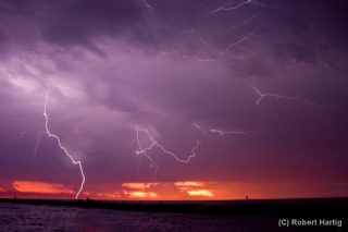
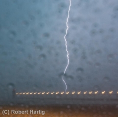
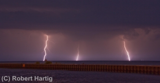
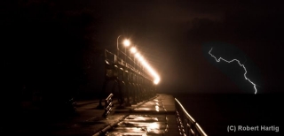
Last night brought a nice electrical display to the Michigan skies, and my little town of Caledonia was smack in the center of the action.

Today looks to present still more possibilities. With a cold front sweeping in to kick up around 3,000 J/kg CAPE in the presence of 45 knots 0-6 km shear and adequate low-level helicity, southern Michigan is outlooked for a 5 percent tornado risk. It had to happen sometime. Looks like today could be play day for my area on toward the southeast part of the state.

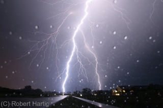
But that’s for later this afternoon, and this post is about last night with its lightning extravaganza. I had initially set up shop in a parking on the edge of town off of 100th Street, but when the action appeared to be migrating south of me, I dropped down six miles to Middleville. Eventually I wound up

back in Caledonia just a couple hundred yards from where I had initially positioned myself. That’s where I got the dramatic shot of the big bolt at the top of this post, as well as the rest of the night-time photos.

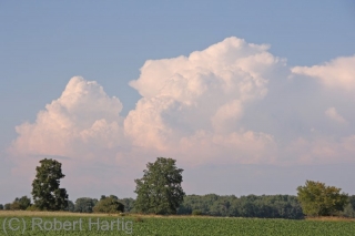
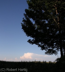
For that matter, the earlier photos were also taken in Caledonia. The color in those photos is pretty true. I was captivated by the bluish hue and undulating, textured look of the clouds. Really beautiful, and quite something to see.
Tornadoes in North Central Nebraska

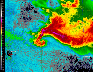
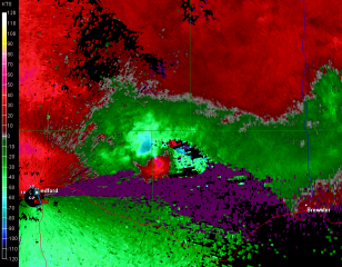
With family visiting from various long-distance places of the globe, I’m not posting much these days. However, last night provided an interesting spate of late-season tornadic activity in north-central Nebraska that I’d be remiss in not slapping up a couple images from GR2AE at the peak of the activity.

Look at that pinhole in the reflectivity knob! I was even better defined in the ensuing scan, after which the rotation became more diffuse and the storm began to weaken. Prior to this, a few dedicated and fortunate chasers videotaped a nice

stovepipe tornado near Wood Lake. All this in northwest flow with the storms moving in a south-southeasterly direction.

First Public Speaking Engagement

Yesterday morning I delivered a presentation on storm chasing for the residents of Covenant Village, a retirement community on the west side of Grand Rapids. The event was my baptism as a public speaker, and it went very well. The positive comments I received encouraged me that I did a good job for a greenhorn. But then, I had a compelling topic and plenty of material to make up for my lack of experience behind the podium.

I spent most of the previous day organizing my notes and photographs. By the time I was finished, sometime around midnight, I had a collection 37 images, including two radar screens. I also had seven pages of notes that covered

• who storm chasers are, what they do, and why they do it; and my own growth as a storm chaser;

• severe weather in Michigan, using this year’s May 29 straight-line wind event in Battle Creek as an example;

• basics of a tornadic supercell, tracking the June 5, 2010, Elmdale, Illinois, storm from initiation to tornadogenesis to impact on a small community;

• and finally, my most intense personal experience to date, that being May 22, 2010,  in “The Field” near Roscoe, South Dakota.

Inviting my audience to interject with questions made for more organic, interesting communication. A number of  people responded with some excellent questions, and I liked how those freed me from the tyranny of my notes. I really don’t like to getting my nose stuck in a pile of notes–they interrupt my flow. Hopefully I’ll get more speaking opportunities, and those will help me to internalize my material, at which point I’ll be able to jettison the notes entirely.

At the request of organizer Linda Kirpes, I concluded my talk with a rendition of “Stormy Weather” on my saxophone, followed by my theme song, “Amazing Grace.” Probably most speakers don’t cap their presentations in such fashion, but it suited me, and I’ll do it again if I get the chance. The storm and the horn of “Stormhorn” go together, after all.

Lightning at the South Haven Pier

Yesterday’s slight risk for Michigan looked more impressive in the models than it did up close and personal. With dewpoints as high as a sultry 78 degrees Fahrenheit in Caledonia (courtesy of my Kestrel 4500 weather meter), MLCAPE upwards of 3,500 J/kg, and 40 knots at 500 millibars, the ingredients were all present for a decent severe weather event. Backing surface flow even suggested the possibility of tornadic spin-ups, though winds at the surface were weak.

For all that, the storms when they finally arrived were pretty garden variety, with one exception: the lightning was absolutely spectacular, a

nonstop flickerfest bristling with CGs. The lines rolled across Lake Michigan in two rounds. Thanks to some good input from Ben Holcomb, I chose to set up shop at the South Haven beach, a great strategic location, arriving there in plenty of time to intercept round one. Kurt Hulst met me there, and we got our live streams going and tripoded our cameras as the northern end of the line bore down on us.

It was too dark to see the shelf cloud very distinctly. I tried to capture it with my camcorder; I haven’t viewed the footage yet, so I don’t know how it turned out, but I soon realized that I’d be better off working with my still camera, which I got mounted right about the time that the gust front arrived. The rain was near-instantaneous, escalating within moments from errant droplets to a horizontal sheet, and I scurried back to my car while collapsing my tripod as fast as I could.

What a great light show! After a lot of teasers this year, I finally got a chance to get some good lightning shots, particularly as the storm moved off to the east. With CGs ripping through the air over South Haven, anvil crawlers lacing the sky overhead, and now and then a brilliant bolt tracing a path from the sky to the lake across the canvas of a molten sunset, yesterday evening was a lightning photographer’s dream. Kurt is a great hand in that regard, and he captured some fantastic images. But for once, even I managed to get some shots I’m pleased with. Here are some of my better ones. Click on them to enlarge them.

As the storm moved on, a good number of people returned to the beach with their cameras to capture the amazing sunset and the lightning display. Storm chasers aren’t the only ones with an eye for the drama that the sky provides!

Some of my photos were taken later on, as the second line of storms was moving toward the shore. I’m particularly pleased with my shot of a lightning bolt off to the right of the pier; it’s a moody, mysterious image, and I intentionally left plenty of dark space at the bottom left.

I might add that the pics with raindrops all over the foreground were taken from my car during the height of the first storm. While I’d of course prefer nice, clear images, I don’t mind the drops. They lend a somewhat Impressionistic feel to the photos. At least, that’s what I tell myself.

Distant Storm: Impressions of the Michigan Summer Sky

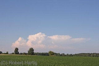
With the humidity scoured out of the air by a cold front that had passed overnight, and with high pressure dominating the area, yesterday was hot but pleasant. Patches of fair-weather cumulus grazed overhead like sheep in a high, blue pasture, but they disappeared as the afternoon progressed. By evening, the sky was a flawless blue, except to the north and northeast, where a few isolated turrets were trying to push through the cap.

Thinking they wouldn’t succeed, I paid them little attention. So I was surprised when one of them muscled up into a nice little multicell thunderstorm near Mount Pleasant. I was in Portland at the time, and with the storm almost directly to my north and me having nothing better to do, I decided to get a better look. It was a weak cell with a high base and a mushy anvil, but it was also the only storm going. And there is something about a solitary cumulonimbus drifting through the broad blue heavens that captivates me. Even a garden-variety, multicell summer storm is a sublime thing when mounted in the gracious frame of azure sky and green Michigan landscape, with miles and miles of farmland and forest stretching outward from one’s feet into forever.

Naturally I snapped a few photos. Then I let the storm go. It was too far away, and it wasn’t anything worth chasing. But it was lovely to watch, and a beautiful accent to a pleasant late-July evening.

Sunset at Hall Lake

The biggest weather news lately has been the heat wave that continues to brutalize the central and eastern United States. Thankfully, these last two days have been easier to take here in Michigan. Friday evening a weak cold front passed through and dropped the dewpoints down into the livable mid-60s for a short while, and since then, variable cloudiness has helped to modify the temperatures.

Yesterday we were in a slight risk area, but with a warm front laying along the Indiana border, the southern tier counties are where convection broke out in Southwest Michigan. One cell near Cassopolis showed sustained, deep rotation on the radar, and Kurt Hulst and I discussed going after it. Given the distance and marginal conditions, we decided to let it go.

Instead, I headed out the door later on with my saxophone and my fishing rod, as well as my camera and laptop just in case storms developed within easy range. Not that I expected any, and none materialzed to divert me from casting a line into the water for the first time in a couple of years.

It felt good to get back at fishing, and picturesque Hall Lake in Yankee Springs Recreational Area was the perfect place to do so. Forty-two acres in size and sporting a small island in its middle, Hall Lake attracts just a handful of fishermen, to whom it offers a tranquil option to the much larger, all-sports Gun Lake to its west. Tucked in a wooded valley, where it is bordered to the south by Gun Lake Road and cradled by the glacial hills of Barry County, it is a place where a man can go to withdraw from the madly rushing world, stand at the water’s edge casting topwater lures into the evening, and let his thoughts slow down to a casual stroll.

I’m no great fisherman. What I do with a rod and reel is more accurately described as dredging. But the fish were eager feeders yesterday, and it took only a few casts before I landed a nice little 12-inch bass–big enough to keep, but I released him. I viewed it as my Father smiling at me for getting back to a hobby that I’ve never mastered but always enjoyed.

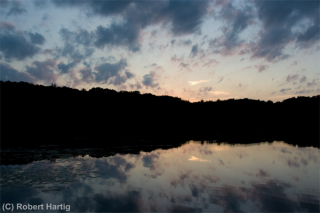
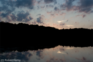
More casts netted me nothing, and presently my interest shifted to the sky. The sun had slipped below the treeline, and a flock of fractocumulus passing overhead articulated the twilight. No fiery sunset, this, no Van Gogh sky; just a gently fading afterglow filled with nuance and calm emotion, silhouetting the forested shoreline and glimmering, spirit-like, in the quiescent mirror of the lake.

It was a scene worth capturing with my camera, and I have done so. Click on the images to enlarge them. I like them, and I hope you will too.

Worst of the Michigan Heat Wave

This has got to be the crest of the heat wave that is assaulting the nation, at least as far as the western Great Lakes is concerned. Here at my apartment in Caledonia, Michigan, I just took a read with my Kestrel 4500 weather meter of 98 degrees F temperature and a dewpoint of 81. Eighty-one freaking degrees! And a heat index of 122 F.

I couldn’t believe my eyes. Then I thought, okay, I logged that data on my third-floor balcony, where I keep my well-watered collection of carnivorous plants. Sensitive as the Kestrel is, it may have picked up on the moisture from the planters.

So I scooted downstairs and took another read, and this one produced more modest results of 91/76/102. Not as bad as out on my balcony, but still just downright nasty.

A weak cold front is forecast to move through here sometime this afternoon and lower the dewpoints a few degrees. I hope it happens; I’m all for taking five or so degrees of dewpoint temperature and shipping them off somewhere where they’re needed. As things stand, I don’t even want to venture outside. But I’m afraid I’ve got to. Once this post is published, it’ll be time for me to hop into my oven-like Buick Century and head over to my mother’s house, there to perform my weekly ritual of vacuuming the carpet.

Whatever would we do without air conditioning on days like this? I don’t know how people manage who don’t have it.

Here Comes the Heat

The ridge that is setting up over the central and eastern CONUS looks like it’s intent on sticking around for a while. The GFS and Euro differ in the details, with the Euro painting a more meridional pattern farther out, but either way, high pressure not only is paying us a visit, but seems intent on securing long-term lodging. Lacking access to the full range of the ECMWF, I can’t compare it and the GFS beyond 168 hours. Beyond that time frame, though, the GFS doesn’t look pretty. Today’s 6Z run shows the ridge expanding and flattening out before ultimately retrograding and bringing in a cool-off in the Great Lakes sometime the week after next.

Until then, it looks like we’re in for some prolonged sweltering. With temperatures moving up into the nineties and dewpoints hitting the low to mid seventies, there are going to be a lot of air conditioners going full-tilt from the South through the heartland and eastward. If you’ve got a boat or easy access to the beach, you’re in business. Otherwise, with heat indices around 100 degrees forecast here in West Michigan for this coming week and probably on into the next, being outdoors is not going to be a pleasant experience unless sweating like a sprinkler system is your passion.

So much for my humble forecast. I’ll leave it to the NWS forecasters to paint in the daily details and will be glad for whatever popcorn cells bring a welcome shadow, a spate of rain, and brief coolness to the area. Today looks to be the first day of the warmup. From here on, things get nasty and tank tops will be de rigueur.

The Historic 2011 Tornado Season in Review: A Video Interview with Storm Chaser Bill Oosterbaan, Parts 2-4

This post continues from part one of my video interview with Bill Oosterbaan on his storm chases during the monumental tornado season of 2011. Since the interview involves one chaser’s recollections, it obviously can’t and doesn’t embrace the entirety of this year’s significant tornado events, such as the April 9 Mapleton, Iowa, tornado and the April 14–16 outbreak.

The latter event was historic in its own right, the worst outbreak to occur since February 5–6, 2008. During most years it would have been the biggest headline maker for spring storms; yet in 2011, it got eclipsed three weeks later by the deadly super outbreak of April 25–28; and again on May 22 by the heartbreaking disaster in Joplin, Missouri, where 158 lives were lost.

The tornadoes of 2011 will long be remembered for for their violence, size, and path length; for their sheer number; and for their devastating impact on large towns across the South and Southeast. In the following videos, my friend and long-time chase partner Bill talks about his experiences in Arkansas, Alabama, Oklahoma, and Nebraska. If you haven’t already seen Part 1, I encourage you to start there and view the entire interview in sequence.

These videos constitute a person-to-person conversation, not a series of tornado clips. In fact, due to issues with his camera, Bill regretfully didn’t get the kind of video record he hoped for. He did, however, manage to film the Vilonia, Arkansas, wedge; and, equipped with a new camcorder on June 20, he captured some interesting and exciting footage in Nebraska, some which you can view here and here.

Bill, while I couldn’t join you on most of your chases this spring, I’m glad you had such a successful season. I know the dues you’ve paid over the years. You’re the McCoy.

The Historic 2011 Tornado Season in Review: A Video Interview with Storm Chaser Bill Oosterbaan, Part 1

Just about any way you look at it, the 2011 tornado season has been exceptional, disastrous, spectacular, and heartbreaking. On April 25–28, the largest tornado outbreak in United States history claimed over 340 lives over a span of 78 1/2 hours. Hardest hit was northern Alabama, where 239 of the fatalities occurred. Of the 335 confirmed tornadoes that drilled across 21 states from Texas and Oklahoma to as far north as upstate New York, four received an EF-5 rating, a figure surpassed only by the 1974 Super Outbreak. In other ways, what is now known as the 2011 Super Outbreak rivaled its infamous predecessor of 37 years ago. There were more tornadoes. And, in an age when warning technology and communications far outstrips what existed on April 3–4, 1974, there were nevertheless more deaths.

The 2011 Super Outbreak alone would have set the year apart as a mile marker in weather history. But less than a month later, on May 22, another longstanding record got broken–and tornado records are rarely anything one hopes to see beaten. In this case, a mile-wide EF-5 wedge that leveled Joplin, Missouri, became not only the first single tornado since the 1953 Flint–Beecher, Michigan, tornado to kill over 100 people, but also, with a death toll of 153, the deadliest US tornado since the Woodward, Oklahoma, tornado of 1943.

This has been a year when large cities have gotten smeared, churned into toothpicks and spit out at 200 mph. Tusacaloosa, Birmingham, Huntsville, Joplin…if you survived the storms that trashed these towns, you were blessed. And chances are, you know people who weren’t so fortunate.

Rarely has the dark side of the storms that storm chasers so passionately pursue been on such grim and devastating display. This has been an awful tornado season, and that’s the truth. It has also been a spectacular one, and if many of the storms were man eaters, yet many others spun out their violent beauty harmlessly out on the open plains. Chasers this year have witnessed the full gamut, from April’s deadly monsters that raced across Dixie Alley to slow-moving, late-season funnels that meandered grandly over the grasslands.

For me, the season has largely been a washout. Family and economic constraints kept me mostly benched this spring, and the few times when I made it out west to chase were unproductive.

Not so, however, with my friend and chase partner of 15 years, Bill Oosterbaan. Bill has had a spectacular and a sobering season–and in this first-ever Stormhorn.com video interview, he’s here to talk about it.

The 40-minute length of this video requires that it be broken into four sections in order to fit YouTube requirements. It’s a lengthy process, and me being a novice at video editing–particularly with high definition–it has taken me a while to figure out how to make it work. This evening I finally had a breakthrough, and now I’m pleased to say that Part 1 is available for viewing. I will be working on the remaining three parts tomorrow, and I hope to have them available in their entirety on YouTube by Wednesday. [UPDATE: Parts 2–4 are now available for viewing.]

For now, by way of a teaser with some substance to it, here is the first part.