Back Yard Chase with Possible Wall Cloud

I hadn’t planned to chase storms today, but Kurt Hulst made me an offer too good to turn down, and off we went. For all the hoopla, with a tornado watch covering most of Indiana and Ohio and a 10 percent tornado risk outlined in exactly the same area south of the Michigan border as last week, the storms nevertheless turned out to be pretty garden variety.

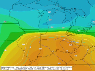
In fact, nothing materialized south of us where we expected it to. Instead, Kurt and I got pleasantly surprised when a couple of cells fired up to our west near Plainwell and almost immediately took on supercellular characteristics. A southwest-northeast-oriented outflow boundary was working its way east, and it provided convergence that fired up a slowly growing line of storms in the weakly unstable warm sector.

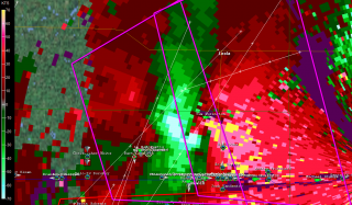
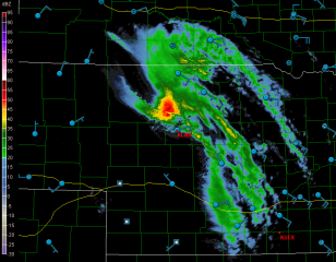
We locked onto a promising-looking cell in central Michigan whose top, at between 40-45,000 feet, was the highest of the day. Base level SRV showed on-again/off-again weak circulation for this storm, and reflectivity had it

hooking nicely at different times. It was no monster supercell, but it had its moments. I took photos of a nice lowering while parked just south of the intersection of R Drive and 23 Mile Road 12 miles south of Charlotte. I’d call the feature a wall cloud. While I couldn’t verify rotation, the vertical motion and the position of the lowering just south of the rain shaft under the updraft base were pretty suggestive.

What you see was as good as it got. I reported the lowering to KGRR after taking the photos, but the storm began to crap out on us even as I was talking with the meteorologist. We dropped it a few minutes later and headed south to catch a new, developing cell. We’d probably have done better to stick with what we had, as it appeared to strengthen again briefly on radar while the new one went linear right away.

Chases in Michigan more often than not prove to be just entertaining diversions–fun, but it ain’t Kansas, Toto. This one fit that description. It was good to get out with Kurt, and also good to get home without having spent too many miles chasing nothing of any consequence.
May 7, 2010, Northwest Ohio Supercells

Yesterday’s outbreak of supercells in the southeastern Great Lakes was no tornado breeder, but it made for an enjoyable chase. I left Caledonia around 10:30 with Bowling Green in mind as a target, noting that the SPC had outlooked a narrow, northern swath of northeast Indiana and northern Ohio with a 10 percent tornado risk.

I wound up rendezvousing with my long-time chase buddy Bill Oosterbaan in Ashton, Indiana, where Mike Kovalchick also joined us. (Note to self: that Baptist church parking lot on the west edge of town has a fantastic hilltop view to the west.) We dropped south to Waterloo, where I parked my car at a convenience store, then hopped in Bill’s vehicle, and we headed east, watching as a cumulus field began forming overhead. The warm front was moving in, and when we left Ashton, the chilly temps were already rising and bringing the dewpoints with them.

Farther to the east, we hooked up with Ben and Mike Holcomb, and CMU meteorology students Aric Cylkowski and Cort Scholten. Our contingent of four vehicles at the Sonic drive-in made up what was probably the first chaser convergence that Bryan, Ohio, has ever experienced, and probably the last.

From there, we dropped south toward the warm front, which had stalled over the area. Temps had been in the lower 70s in Bryan, with east-northeasterly winds and dewpoints around 59 degrees; farther down the road, at our new location in a parking lot next to a cemetery, we gained another degree of dewpoint and the surface winds veered. On the radar, one discrete cell to our southwest began to take on supercellular  characteristics. We decided to intercept it, and the chase was on.

But another cell formed southwest of our storm, and in its tail-end position, it rapidly evolved into the main player of the day. So we left the storm we were on and headed toward the new one, which was hooking nicely. A couple miles south of the town of Paulding, we encountered one of the most flat-out beautiful hailstorms I’ve ever seen. It moved toward us in shifting, pearly strands across the fields. I tinkered frantically with the settings on my camera in order to get a fast enough shutter speed for snapping pics from our moving vehicle–there was no shoulder to the road, and no stopping–but by the time I finally had what I needed and Bill had found a turn-off, the amazing nuances and texture of the hail shaft had blended into a homogeneous sheet (click image to enlarge). I took a couple quick photos which nowhere near capture the essence of what we had seen just a minute or two prior; then, with maybe thirty seconds to spare from getting cored, we beat a hasty retreat.

Out in the field just to our southwest, we could see a crapload of dust being kicked up by the rear flank downdraft. We pulled aside and let it pass 100 feet or so in front of us. In the photo, notice how the dust fills the ditch to the right. I’ve read some discussions about the wisdom of the longstanding advice to abandon one’s car during a tornado and seek shelter in a ditch. Maybe that’s a best option in a worst-case scenario, but judging from the photo, it looks to me like the wind is doing a pretty good job of invading the ditch. Depending on the depth of a given ditch, tornado-force winds could conceivably just scoop a person up and launch them into the main air stream.

But I digress. The hail and RFD were the highlights of the day. From then on, it truly was a storm chase, and a futile one. With the storm rocketing to the east-northeast at 70 mph, we had a choice of barreling eastward and losing the storm to the north, or northward and watching it vanish to the east. We pursued it longer than we should have, but we had a fun time of it. The roads in that part of Ohio are great, the countryside is flat and open, and overall, the territory is fabulous for chasing. But when storms are moving at such breakneck speeds, the best road grids in the country–and these probably qualify–can’t compensate.

I managed to get a few shots of a cool, bell-shaped wall cloud as the storm moved away from us. Eventually, though, we called the chase off and started on our way back. West of Paulding, we encountered significant wind damage–large trees snapped off at their bases and pieces of outbuildings scattered across the fields at a couple farms. Could have been weak tornado damage, but it was likelier the work of straight-line winds.

I should probably mention the rope funnel that hung down from a small storm as we headed back toward Waterloo. Okay, it wasn’t really a funnel, just evidence of what wishful thinking can do with a snaky-looking cloud.

Back in Waterloo, I picked up my car, hit I-69 north, and headed home.

I noticed that Illinois-based storm chaser Adam Lucio was also on these storms, and appreciated his Facebook comment that you don’t need tornadoes in order to have an enjoyable chase. I wholeheartedly agree. Yesterday was a great chase, particularly for the Great Lakes, and that hail shaft near Paulding alone made my day.

Of course, everyone has been rumbling about the big event shaping up for Monday in the Plains. Wish I could go, but it’s not in the budget. Best wishes to everyone who heads out. Stay safe, get good photos and video, and have fun.

April 22-23 TX-OK-KS Storm Chase

As I begin this post, the first major tornado-producing storm system of 2010 is moving to the east after taking 10 lives in the South yesterday. Already a tornado-breeder, the system matured yesterday into a wide-scale outbreak driven by hefty bulk shear, massive low-level helicities in the order of 600 and above, and CAPE values up to 2,500. Yazoo City, MS, was hit hard by a powerful, rain-wrapped wedge. The verdict remains open as to whether this was a single, long-lived tornado that traveled as much as 200 miles, or one in a series, which seems likelier.

Sorry, I can’t offer a write-up on yesterday’s storms. I was home sleeping, and I have no regrets that I missed anything. With the models suggesting rain-wrapped, low-visibility tornadoes rocketing along at 50 mph or more; with the potential for hydroplaning while driving at gonzo speeds in order to keep on top of fast-moving, rapidly morphing storms and avoid having them get on top of us; and with the logistical madness of three sleep-deprived chasers–Bill Oosterbaan, Mike Kovalchick, and me–having to backtrack afterward to Saint Louis where my car was parked and then drive 450 miles back to Grand Rapids, the negatives of chasing this big, messy, and dangerous tornado outbreak seemed to easily outweigh the potential payoffs.

So Bill, who was determined to catch the action, made arrangements to hook up with Kurt Hulst and Bill’s brother, Tom Oosterbaan, in Illinois, and then he dropped Mike and me off at my car. The two of us headed home, and I can tell you, it felt mighty good to crawl under the covers upon my return and sleep until 1:00 in the afternoon. After talking with Tom yesterday evening, I’m glad I chose as I did.

I may have more thoughts to share about yesterday’s scenario, but I’ll save them for another post. The previous two days in Texas and Kansas deserve some attention in their own right, and not just as the prequel to the big, day 3

outbreak. They may have been a bust for me tornado-wise, but they were nevertheless the first decent system of the year and my first chase out on the Plains. It was a blessing to get out on the road once again and see the vast, textured expanses of the Texas and Oklahoma panhandles.

Naturally, the landscape included the TIV2, which at this point should be designated a mobile national monument of the Great Plains. Back in 2008 we had bumped into its predecessor in Nebraska; this Thursday, we pulled into a gas station in Pampa, gassed and Rain-Xed up, then drove around to the other side of the station, and surprise! There it was–the Tank and its entourage. Cool! Who can resist taking a few photos? Not me.

As for chasing storms, Thursday was a should’a. We should’a either listened to Mike and headed for western Kansas, where most of the tornadoes occurred later in the day, or else gone with Bill’s and my initial impulse to chase the bigger CAPE, albeit forecasted low helicities, near Childress, Texas. For that matter, if we had endured the initial grunge in Wheeler, or better yet, just parked along US 60 east of Pampa–in other words, if we had just sat and waited–we’d have been golden. Instead, we sacrificed an opportune position and went after some cells that fired to our northwest along the dryline. Doing so made a certain amount of sense, as those storms were already looking supercellular and were moving toward the warm front and better helicities, while the cells popping up to our south in advance of the dryline seemed to just sit there and languish. So after the northern storms we went.

Bad decision. One of the southern cells developed steam shortly after we made our move. We could still have turned around at that point, but we chose to commit to our decision and wound up betwixt and between the vortex breeding grounds to our south and north. As a result, we found ourselves looking forlornly at the radar as the southern cell shaped up beautifully and began churning out tornadoes, while our storms struggled valiantly but

never quite got their act together. If there’s a lesson to be learned, it’s that good things come to those who wait. And, I might add, that model SRH is nice if you can get it to cooperate, but it can be deceptive. Helicity is prone to change with the storm environment in ways that forecast models don’t anticipate. If CAPE and 0-6 km shear are sufficient, storms may just generate their own low-level helicity.

Anyway, we chased the dryline storms and busted. Our storms tried hard to tornado, but they just couldn’t quite manage to produce. So instead of the blue ribbon, we wound up with honorable mention: some decent structure, including cool-looking wall clouds, a few funnels, and–as tail-end Charlie went high-precip in the Oklahoma panhandle–a nice, banded-looking storm with a formidable shelf cloud.

As for Friday, we picked exactly the right target up in northeast Kansas along US 75 just south of the Nebraska border. We were smack in the axis of a nice moisture plume. But nothing happened. As the afternoon progressed, the cumulus field we were sitting under began to generate towering cumuli, but these turkey towered and busted against a mid-level cap that just wouldn’t erode. So that was that. Looks like a lot of other chasers got disappointed as well by the northern play. It happens. We finally cut our losses around 7 p.m. and headed back east toward Saint Louis and a band of storms that was moving toward I-70. Ironically, one of these produced a series of tornadoes. If Thursday had been a should’a, Friday was an if-only. If only we’d targeted northeast Missouri…but there had been no reason to do so that we could see.

Now another storm system looks to be moving into the Midwest later this coming week. The action could be closer to home, but I’ll think about that in a day or two. Right now, it’s time to make this post, rest up, and get on with the rest of life.

Wavespray on Lake Michigan

no images were found

If March coming in is anywhere nearly as leonine as February going out, it will be a March lion indeed. Today the wind was blowing hard out at Holland Beach, churning Lake Michigan into a grand spectacle of roiling billows, crashing surf, and smoke-like spume torn from the wave tops and carried along on the gale.

It was a marvelous sight. Lisa preceded me out onto the pier, and when I caught up with her, she was standing there, laughing as the waves burst

no images were found

against the ice shelf and threw blasts of icy water toward her. That’s my kind of gal! Someone who takes joy in the wild side of nature.

Unfortunately, the water got all over my camera and onto my lens, so the latter part of my photos are somewhat distorted by water droplets. But I don’t mind terribly, because the effect is actually rather moody. I guess if I was going to have something go wrong with my photos, I would pick that.

no images were found

Speaking of photos, the four here were all taken from the beach and out on the pier. Click on them to enlarge them.

In taking them, I got more soaked than I realized; and the wind chill being what it was with the northwest wind blasting in off the big lake, I rapidly got much colder than I ever expected. But it was worth it to get some shots of Lake Michigan’s raw, unfettered side.

no images were found

I haven’t edited these images. I’m slapping them up here just as they are–maybe not works of art, but a taste of the kind of effect the shoreline is capable of delivering when the gales blow hard across the big waters.

Sunset at Gun Lake

no images were found

A beautiful day and a warmer day. A day too nice to ignore. That’s what today has been, and the beginning of a warming trend, to boot. The snow has been melting on the balcony, and beneath the slanting, southerly light of a cloudless January sky, the birds were going absolutely nuts at the feeders earlier.

“Let’s take a drive,” I said to Lisa. She has been in the middle of a massive crocheting project, I’ve been sequestered inside my own head with various writing projects and

no images were found

weatherly explorations, and it seemed to me that it would do us both good to pull away for a little while and enjoy the remnant of the day.

So off we went with our cameras to Gun Lake fifteen miles to our south in northern Barry County to watch the sun set. I thought I’d share three of the photos I took there in the state park. Click on them to enlarge them.

The deer was one of three yearlings that were hanging out next to the park drive. They were preoccupied with foraging and appeared completely unconcerned about the tan Buick Century that had pulled up alongside them, or the human on the other side of the driver’s-side window who was busily snapping pictures.

no images were found

The bright orange blob is a parasail, and the guy to its left had just finished with an hour or so of snowboarding out on the frozen lake. As for the sunset, that’s self-explanatory. The one thing unique about it is the vantage point out on the Gun Lake ice, a perspective unavailable to me during the warm season.

With nothing bursting at the seams for me to write about either musically or weatherwise, I figured the photos would offer a pleasant diversion. A little splash of color to brighten a mid-winter day never hurts, right?

The Old Carlton Center Church in Charlton Park

With nothing hot brewing on my mind in the way of jazz, and certainly nothing in the weather other than a beautiful, unseasonably warm day, I thought I’d post a photo from yesterday’s excursion to historic Charlton Park.

For me, this shot of the old Carlton Center Church captures the essence of November: forlorn, empty, bereft of the vivid hues of autumn yet not quite committed to the black and white of winter. November is the month when Mother Nature seems to pause and hold her breath before exhaling her first icy blast.

I took a number of photos of the church. This one is actually the runner-up to another that I’ve selected for my weekend article for Waterland Living, but I kept looking at this image and thinking, “With a little more trimming…” I like it. Hope you do too.

If you want to see a few more shots from Charlton Park, a historic village located on Thornapple Lake between Hastings and Nashville, Michigan, go to my Photos page. The park on this day felt like a ghost town, but that’s November for you.

My White-Top Pitcher Plants Are Open for Business!

Bugs, beware! My white-top pitcher plant, Sarracenia leucophylla, has sent up its flush of autumn traps. The two largest traps are open, and they are spectacular. And, I might add, with the weather warming up these past couple of days, they have been doing business. I was there just in time to witness the first

hornet fall prey to one of the newly opened leaves. It landed on the lid, poked around for a bit, then promptly dropped straight down into the tube and wedged hopelessly at the very bottom. Today, with the sun backlighting the leaves, I could see the shadows of more insects, some struggling to get out. It was a rather grim drama playing out under the bright sunshine, but I’m no fan of yellow jackets, and I find it hard to feel much pity for insects that have been known to land on me and sting me just for the apparent mean-spirited hell of it.

Anyway, the two newly opened leaves look stunning, and four more are in various stages of development. I thought I’d share a photo with you; click on the image to enlarge it. You’ll find more shots of the white-top and other North American pitcher plants in the Wildflowers & Outdoors section of my Photos page.

Grasshopper Passion

So here I am, caught on the twin-horned dilemma of no storms to chase and no gigs to play. But you, my faithful readers, are longing for a word from Stormhorn.com, and I feel my responsibility toward you weighing heavily upon me. What can I offer you?

Grasshopper passion.

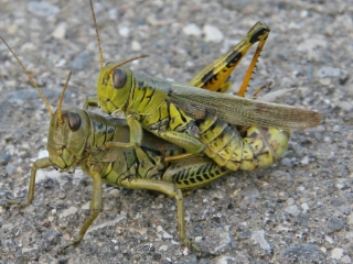
A few weeks ago, back in September, I took a hike at a nature park in nearby Ada, Michigan. Evidently, early fall is the season of love for grasshoppers, a time during which they become the Woodstock generation of the insect world, and in numerous places all along the trail, hoppers were locked in shocking, shameless public displays of unbridled lust.

Somehow, though, I found it hard to take offense. Probably my moral sensitivity has become dulled by Hollywood and advertising. Then again, grasshopper passion just isn’t all that passionate. By way of example, I submit the following photo of a couple locked in the throes of ecstasy. Click the image to enlarge it, though why you would want to do so is beyond me.

I have to say, judging by the looks on their faces, that this pair doesn’t seem particularly excited. In fact, they don’t even appear to be awake. When your brain is the size of an ant booger, situational awareness just isn’t going to be one of your key strengths.

I took a number of shots of these two hoppers, and they all look the same. I can testify that what you see here is as heated as it gets. A minute later, neither of my subjects had moved a solitary grasshopper muscle. It’s as if having sex had turned them to stone. Having better things to do than wait for them to finish their sordid business (Him: “So…was it good for you?” Her: “Was what good for me?” Him: “I’m not sure.”), I moved on.

Taken altogether, insect porn is pretty G-rated stuff, on a par with watching Kermit the Frog eat oatmeal. Parents, no need to shield your children’s eyes. The only trauma they’re likely to experience is boredom.

Lightning over Lake Michigan

The storm system that has been in the models for the past week produced a fast-moving squall line that blew from Wisconsin across Lake Michigan. Kurt Hulst and I were there on the shore just north of Holland, Michigan, to catch the action.

Kurt is a great lightning photographer. Look for his photos of last night’s storm on his blog.

As for me, I’m a neophyte when it comes to lightning. Shooting at night, the problem I encounter is focus. Unfortunately, most of my shots were too blurred to crop, and since I was shooting wide angle, cropping is essential. However, a couple shots didn’t turn out too badly. The one shown here is the best of the lot. Click on it to enlarge it.

Photo of the Kids

I just finished taking photos of the “kids”–my collection of carnivorous plants. They’re mostly North American pitcher plants, but I do have a very prolific population of Venus flytraps as well. The things reproduce like crazy. Not only are the seeds majorly fertile, but the corms love to divide. Start with one flytrap and in a couple years you’ll have a flytrap village.

Anyway, I have yet to process the rest of the photos to place in my gallery, but I thought I’d give you a little preview. The flytraps have been snarfing down bugs like M&M chocolate covered peanuts, so forgive the fly and hornet exoskeletons. My kids are not very good about brushing their teeth.