On the Road to Oklahoma

The southerly breeze blowing from across the field behind me into this shady little park is just enough to render an otherwise hot and somewhat humid noon hour pleasant to perfection. If bathwater could be turned into air and made to blow around me, this is how it would feel, the quintessence of balmy.

I’m sitting at a picnic table surrounded by stately maples robed in the fresh green of May. From every direction comes the chatter and song of birds. A stone’s throw to my right, three fat robins on worm patrol navigate the grass with great singleness of purpose, and somewhere not far away I can hear the whirring call of a woodpecker. I couldn’t ask for a better setting to while away a couple of hours while my buddy Bill lunches with clients at a nearby plant.

Ah, spring! Ah, Iowa! Here in this tiny park in this small town nestled in America’s gently rolling heartland, for a little while I find myself retreating from how life is to how it can be. Quietude is not necessarily quiet, for the air is filled with sounds. But they are subtle sounds, background sounds, sounds of wind and birds that unwind the mainspring of my all-too-preoccupied soul.

Tomorrow I will wake up in Enid, Oklahoma, which looks like a prime base of operations for chasing storms that bump off the dryline. I’ve had my eye on Enid for a couple of days, now, and this morning the SPC issued a moderate risk for tomorrow with Enid smack in its midsection. That bodes well. It’s time at last for a chase in the Southern Plains.

I still have some concerns with this system. But they’re outweighed by the fact that the right stuff is coming together for tomorrow. Even more importantly, it’s May in Oklahoma. An ant can fart and spin up a tornado. And I’ll be there to watch it and experience the drama, beauty, and adrenaline of the atmosphere with my good friend and chaser partner of 15 years, Bill.

Speaking of whom, here he is. Looks like his business meeting is over. Time to pack up, hop in the car, and head west. Adieu, Victor, Iowa. Thanks for providing unknowing hospitality to a stranger in this jewel-like little park beneath the unfolding leaves of spring.
First Great Plains Chase of 2011 This Wednesday

At last, the setup I’ve been waiting for–one that warrants dipping into my tight finances in order to make the 1,000-mile drive to the Southern Plains. To date, this present system has been a miserable disconnect between upper-level support and instability, with a nasty cap clamping down on the whole shebang. Last night it managed to cough up a solitary tornado in South Dakota. That was it. I’m not sure what today holds, but I haven’t seen anything to excite me about it or tomorrow.

But Wednesday…ah, now we’re talking! The SPC places a large section of the Great Plains under a slight risk, and their discussions have been fairly bullish about the potential for a wide-scale event. At first I couldn’t see why. My mistake–I was looking at the NAM, which with straight southerly H5 winds has not provided the best PR for Wednesday’s setup. But once I glommed the GFS, I got a whole ‘nother picture, one which the SREF and Euro corroborated.

That was last night. I haven’t looked at today’s SREF, and the new ECMWF gives me a slight pause as its now somewhat negative tilt has slightly backed the mid-levels from the previous run. But only slightly. The H5 winds still have a nice southwesterly flow, and taking the three models together, everything you could ask for is lining up beautifully for tornadoes in the plains.

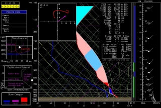
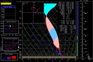
The event promises to be widespread, with a robust dryline stretching from a triple point in southwest Kansas south through Oklahoma and Texas. Positioned near a dryline bulge, Enid, Oklahoma has drawn my attention for the last couple of GFS runs. Check out this model sounding for 00Z and tell me what’s not to like about it. Everything is there, including a voluptuous hodograph and 1 km SRH in excess of 300 m^2/s^2.

Other places in the region also look good, though. Farther south in Texas, Wichita Falls shows potential. Helicity isn’t as persuasive as Enid, but the CAPE tops 3,000 J/kg and there’s less

convective inhibition. Here’s the sounding for you to compare with Enid.

I haven’t been as drawn to Kansas so far, but with the triple point perched there, storms are bound to fire up just fine in the Sunflower State. The details will work themselves out between now and Wednesday evening. Significantly, the tyrannical cap of the previous few days no longer appears to be an issue.

The bottom line is–it’s time to head West! This evening I’m taking off for the plains with my long-time chase buddy Bill. At last! Time to sample what the dryline has to offer, and–now that I’m equipped with a great HD camcorder–finally get some quality footage of a tornado or two.

There’s no place like the Great Plains! YeeeeHAW!!!!!

April 27, 2011, Southern Outbreak: When a Nightmare Becomes Reality

The death toll from yesterday’s tornadoes in the South presently stands at 231,* and it continues to climb. In the battered town of Tuscaloosa, Alabama, 36 people are dead; in Birmingham, at least 30 more.** From

Mississippi to as far north as upstate New York, the worst tornado outbreak in 37 years has left communities sifting through a battleground of leveled buildings, crumpled automobiles, downed power lines, tortured trees, and a horrifying number of casualties. This has been no mere tornado outbreak; it has been a tornado nightmare.

“You’re talking about whole neighborhoods of housing just completely gone,” said Birmingham Mayor William Bell in an NPR interview. “Churches, gone. Businesses, gone. I’m not talking about just roofs being blown off, but just completely gone.”**

I knew that a dangerous weather event was brewing in the South yesterday. But with my mother undergoing a knee replacement, I spent most of the day at Blodgett Hospital here in Grand Rapids, Michigan. I knew nothing of what was transpiring down in Mississippi, Tennessee, and the epicenter of the outbreak, Alabama, until later in the evening, when I finally left the hospital, fired up my laptop, and got my first look at the radar.

There it was, spread out before me: a blitzkrieg of intense supercells swarming across Alabama and Tennesse, attended by so many tornado reports that they obscured parts of the map. My heart dropped into my gut. I didn’t need any news reports to tell me that something awful was happening and people were getting killed.

Immediately I thought of my long-time friend and storm chasing partner, Bill Oosterbaan. He was down there somewhere in Alabama. I had no question that he’d seen tornadoes, but was he safe? I couldn’t reach him at first on his cell phone, but eventually we connected and Bill shared his story. He had been about a quarter-mile behind a tornado that hit Huntsville and gotten rained on by debris. It sounded bad, but Bill was okay, had witnessed five tornadoes, and had gotten video footage.

After talking with Bill, I began searching for news on Facebook and the Internet. The first video I saw was Chris England’s footage of the Tuscaloosa tornado as it chewed through the city. “Andover!” I thought. “It looks like the Andover tornado.” (An F5 monster that struck Andover, Kansas, on April 26, 1991.) More YouTube videos followed: Mind-boggling views of the Tuscaloosa storm. TWC footage of a violent, mile-wide wedge moving through Birmingham. An intense tornado striking Cullman. It was horrible. The storms were ongoing even as I watched, and it dawned on me that, overworked as the word “epic” has become, here was a situation where it applied.

I am appalled by the news and deeply saddened. As good as today’s weather warning system is, nevertheless the death toll is mind-numbing. I frankly expected a few score fatalities, and that in itself would have been too many. Lives are lives. But this many lives…it is just sickening. Were it not for the unswerving vigilance of the Storm Prediction Center and the National Weather Service; and were it not for today’s NEXRAD system that blankets the nation with Doppler radar to provide coverage that far outstrips what existed during the historic 1974 Super Outbreak and 1965 Palm Sunday Outbreak; were it not for these things, then the death toll from yesterday would have been apocalyptic. As it stands, it is horrifying, and the number continues to grow.

My writing on this event is finished for now. There is simply too much to say and too much news that is yet breaking, along with countless hearts. The story has just begun, and more can be told only as it becomes known. My thoughts and prayers go out, with those of countless other storm chasers, to the survivors of this terrible disaster.

————————————

* From CNN’s live blog.

** From NPR’s news blog, “The Two-Way.”

Sax and Wedge: Maybe This Year

This afternoon I have a gig with Paul Lesinski at the Amway Grand. I’m looking forward to it, but it indisposes me to chase what could be Michigan’s first round of severe weather this afternoon. Practically speaking, the “storm” and “horn” parts of Stormhorn sometimes conflict with each other. I can’t do two things at once; I can’t play a gig and chase storms, and when I post here about one subject, then the other half of my readership gets left out.

Yet I view the two interests as connected in spirit, to such an extent that one of my life goals is to get some footage and/or photos of me playing my sax out on the Plains with a big wedge churning in the background. Given how active this April has been, maybe 2011 will be the year when I fulfill that ambition. I almost always bring my horn with me on my long-distance chases for just that reason (plus, yeah, I like to get in some sax practice when I can). The one notable occasion when I left it home last year was on May 22, a milemarker in my chase career. Unfortunately, the vehicle was so packed that there was no room for the horn, and given how events unfolded out there by Roscoe, it was probably just as well.

Today my buddy Bill is chasing down in Arkansas. Yesterday he filmed a large, violent wedge that hit the town of Vilonia. Round two today looks to be at least as bad, and I hope Bill stays safe. I don’t have a good feeling about what lies in store for the folks in that region. But I won’t be following any of the developments because I’ll be doing the other thing I love as much as storm chasing: playing my saxophone. This time of year the storm chaser in me has the edge over the musician, but once I’ve got my horn in my hands I forget everything else and just go with the flow of the music. Playing jazz is one of the most in-the-moment experiences a person can have, and I get tremendous satisfaction out of being a practitioner.

Afterwards maybe I’ll still get a crack at whatever weather shapes up. Probably not; today, such as it is, looks like it’ll play out on the eastern side of the state.  But I’ll take my gear with me to the gig just in case.

April 14-16 Southeast Tornado Outbreak: Thoughts and Images

There are times when the sight of a high risk sickens rather than excites me, and Saturday was one of those days. It’s one thing when severe storms occur in the Great Plains where the population is sparse, but when a swarm of tornadoes roars across an area punctuated with cities and towns, all I can think is, “Oh no. All those people!” Such was the case with last week’s horrendous three-day tornado outbreak across the South and East.

The outbreak commenced Thursday in Oklahoma, Kansas, and Arkansas, with a preliminary figure of 27 tornadoes reported.* The action ramped up Friday in Louisiana, Kentucky, Missouri, Illinois, Mississippi, Alabama, and Georgia, with an initial tally of 120 tornadoes. Day three was the worst of all, with yet another 120 reported tornadoes slashing across the populous, densely forested Southeast and East from South Carolina to as far north as Pennsylvania. Hardest hit was North Carolina, where large and powerful tornadoes ripped through Raleigh and other communities. Twenty-two lives were lost, 11 of them when a three-quarter-mile-wide, EF3 monster carved a 19-mile path across Bertie County. Another six died in Virginia. And in its previous two days, the outbreak claimed seven lives in Arkansas, seven in Alabama, two in Oklahoma, and one in Mississippi.

In all, Saturday’s tornadoes were North Carolina’s most lethal since 1984, when 42 died. And regionally, Friday and Saturday were the worst tornado outbreak in the Southeast since the Super Tuesday Outbreak of February 5–6, 2008, when 87 tornadoes killed 57 people in four Dixie Alley states.

But my point in writing this article isn’t to provide yet another news story on the disaster. Rather, it’s to share my feelings as I watched it unfold. With some truly amazing video coming in from chasers in Oklahoma, the first day was fascinating. Day two, watching tornadic supercells crawl across Mississippi and Alabama on the radar was unnerving; I hoped nothing bad would happen down there in the South, but I knew better. On day three, when I saw the high risk go up in North Carolina, my heart sank.

When it comes to armchair chasing, I’m moderate in my habits. If I can’t actually be out chasing, I often opt for a more constructive use of my time than watching the radar and gnawing my knuckles. This time, though, I couldn’t help watching. At first the line of storms looked mean but not terribly alarming. As the storms headed east, though, they began to organize and strengthen, and circulations began to show on radar. Strong circulations, a whole line of them, stretching from northern South Carolina up into Maryland and Virginia. And the tornado reports began filtering in. These storms didn’t merely appear to be impacting towns–they were.

I watched one monster chew through Raleigh, thinking, “No way!” Then came the videos on YouTube, one of them by chasers at unnervinglyclose range, and I knew. No one was dodging the bullet this time. Neighborhoods were being pulverized and people were dying.

With fiscal conservatives recently wanting to slash the budget of the National Weather Service, all one has to do is witness a scenario like last weekend’s in order to realize the supreme lunacy of such a move. Tornado season is just getting started. More is on the way. Bad as last week was, we could yet see worse. How smart is it to pull the rug out from under our national weather warning system at precisely the time of year when its optimal service is most needed?

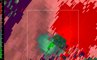
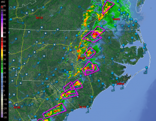
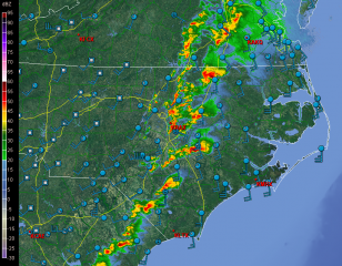
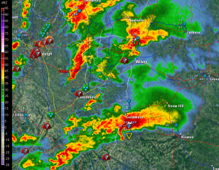
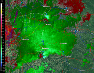
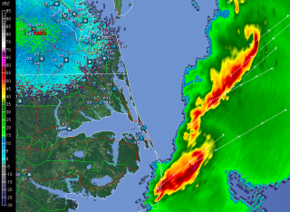
But I digress. Here are a few GR2AE radar grabs of the North Carolina supercells. Storm motions were to the northeast. The rest tells its own story if you know what you’re looking at.

First, here’s are a couple macroscopic views.

Next, I’ve zoomed in on the Raleigh radar to  cross-check reflectivity and storm-relative velocity on a couple supercells.

The final image was taken after the storms had moved out to sea. It shows a couple of northern line-end vortices that I found interesting and thought you might too.

____________________
* All numbers reflect preliminary reports at the time of this post’s publication. Final statistics will likely be different.

Highway Work during Tornado Watches and Warnings

Last Sunday, April 10, 2011, while chasing storms across central Wisconsin on a moderate risk day, my three teammates and I found ourselves stranded in a traffic bottleneck on eastbound I-90 just west of Oakdale. Ordinarily I would have viewed the situation as merely an inconvenience, but with a tornado-warned supercell bearing down on us, and with the radar showing pronounced rotation making a beeline for our location, the matter elicited somewhat greater concern. We could see what appeared to be the mesocyclone advancing over the hilltops. But we couldn’t do a thing about it, nor could any of the several hundred other vehicles that were backed up for a mile or two in both directions, courtesy of the Wisconsin Department of Transportation.

Fortunately, nothing tragic happened. But it could have. The storm wasn’t merely Doppler-warned–it produced a number of tornadoes. We encountered some of its handiwork later on in Arkdale, consisting of a good quarter-mile-wide swath of shredded trees and badly damaged houses. Had the storm gone tornadic a few miles prior, it would have gobbled up helpless motorists like a giant Pac Man in an M&M plant.

What highway department contractor made the outrageous decision to hold up traffic in a way that put hundreds of people directly in harm’s way with no escape? The storms didn’t form in an information vacuum. Three days prior, the Storm Prediction Center had already outlooked the area as a moderate risk. Forecasters had been consistently harping about the possibility of strong, long-lived tornadoes. The weather was hardly a surprise that caught road repair team leaders unaware. So my inevitable conclusion is that some boneheaded foreman was so hell-bent on getting the job done at all costs that he or she willfully exposed hundreds of drivers to a potentially deadly weather event.

Such action is worse than irresponsible; it borders on criminal. I do not want the highway department making dispassionate decisions that risk my life and a multitude of others on behalf of a DOT schedule. How much time would have been lost rather than saved had the worst happened and the focus shifted from road work to emergency response? With scores of crumpled vehicles strewn along the highway and scattered across the field, how would the Department of Transportation have explained a common-sense-be-damned approach that resulted in multiple deaths and injuries?

The incident I’ve cited is just one of innumerable highway closures that occur all across the Midwest due to road work that continues despite tornado watches and warnings. It’s not the first time I’ve encountered the practice, just the most infuriating, and yes, the scariest because of the immediacy of the storm. I doubt anything I say here is going to change the mindset responsible for such scenarios, but it deserves to be called out for its life-endangering lunacy, and this is as good a place as any to do so. It’s my blog, and right now I feel like using it to rant.

WisDOT, what on earth were you thinking, assuming that you were thinking at all? Get a clue: Public safety trumps your deadlines. Evidently someone in your ranks felt differently last Sunday, choosing to put hundreds of motorists in jeopardy rather than suspend road work on account of a tornado warning. Does that kind of decision accurately reflect your policy? If so, then those of you in charge ought to be flogged at noon in the middle of the town square.

However, a more constructive alternative would be for you to re-examine your guidelines for road work during severe weather, and to make whatever changes are necessary in order to put the public’s interests ahead of your own.

Storm Chasing for TV 8: Taking It to the Next Level

I met this afternoon with WOOD TV 8 meteorologists Kyle Underwood and Matt Kirkwood to discuss chasing storms for TV 8. I’m excited about the prospect of taking what has hitherto been a longstanding hobby of mine, albeit one of passionate focus, and upgrading it to the semi-professional level.

When Ben Holcomb left Michigan last year for the grand storm chaser’s Mecca of Oklahoma, he offered to hook up several of his Troll compatriots with TV 8 to fill his vacancy. One of those chasers was me. At the time, gracious as Ben’s offer was, I nevertheless felt I had to decline due to a pathetic lack of equipment. But the thought of the opportunity kept nagging at me, so I finally decided to take a chance and purchase some stuff I really can’t afford out of the sense that I can’t afford NOT to do so. My gut instinct, which I hope is right, is that my investment will pay for itself over the storm season. Thus, motivated by the possibility of having my avocation become self-sustaining, with tax writeoffs on mileage and expenses as an added incentive, I dropped a healthy chunk of cash on the following items:

  • ♦ Panasonic HDC-TM700 video camera with 32 gig internal memory
  • ♦ 32 gig HDSC memory card
  • ♦ Logitech Pro 9000 webcam for live streaming video

The cash outlay is not one I take lightly at a time when my money is tight. It’s a good barometer of how seriously I take storm chasing. But after speaking with Kyle, I’m impressed that WOOD TV appears, on its part, to be equally serious about developing a topnotch crew of local chasers. Commitment matched with commitment is a good thing.

Besides my purchase of equipment, over the past few weeks I’ve also invested a good amount of my time and a bit more cash studying for my HAM radio test, which I took and passed last Friday. Today I finally found my new call letters in the FCC list, so I’m now officially good to go as a HAM operator.

Additionally, per Lisa’s recommendation, I’ve registered with Vimeo, and after giving it an introductory look-over, I feel good about that resource as an online video repository. Vimeo should allow me to start embedding my footage in future Stormhorn.com blog posts, and it may also serve as an easy way to make my material accessible to WOOD TV.

All that now remains to be done is to sign up with Chaser TV and start getting familiar with the live streaming video. That and familiarize myself with Vimeo and its capabilities. I’ve got a bit of a learning curve ahead of me between now and April 1, when WOOD TV hopes to begin tapping into its chaser pool.

Since all the chasers in that pool know each other–it’s a small, connected community, as I’m sure storm chasers anywhere will understand–there’s the potential for some decent synergy on a chase day. What one man misses, another is likely to catch.

So…a new experience lies ahead for 2011. No way am I missing big weather when it shapes up out west in Tornado Alley. But if statistics mean anything, this year’s La Nina could bring a bonanza of severe weather closer to home, even to my back door of West Michigan. When it does, I’ll be on it, dashcam streaming and camcorder a-blazin’.

What Do You Need to Chase Storms?

“How do I become a storm chaser?” If you’ve been asking that question, this post is for you. I write it with some reservation, knowing that there are people more qualified than I to address the topic. That being said, I’ve been chasing storms with some modicum of success long enough now that I’m confident my insights can have value for those who wonder what it takes to get started.

What do you need in order to chase storms? I’ve seen some lengthy lists developed in response to that question. The input is good, but it can overcomplicate matters, and too much of it all at once can be daunting. If you focus on the word “need,” the answer is much simpler. That’s my approach here: strip it down to the basics, then build from there.

The Foundational Stuff

Here, in my opinion, are the few things that a storm chaser cannot do without:

◊ A roadworthy vehicle, be it yours or a chase partner’s. By “roadworthy,” I mean one that can successfully manage the terrain you’ll be chasing in. If your territory is the flatlands of Illinois and Indiana, or if you intend to stay on main roads that aren’t likely to run out of pavement, then pretty much any vehicle will serve you. On the other hand, if you plan to chase down west Kansas backroads, then you’d better have four wheel drive and great tires; otherwise, the clay out there will slurp you down and ruin your day.

◊ Road maps. Self-explanatory, I think.

◊ Money. You need gas for the tank, right? And maybe a burger along the way.

◊ Basic knowledge of storm structure. Sure, you can chase storms without knowing anything about their features and behavior. But you can’t chase them safely, and the odds of your chasing them successfully are slim. So learn all you can. West Texas storm chaser Jason Boggs has created an outstanding list of educational resources that you can access as quickly as you can click your mouse. Jason’s list mixes basic and advanced material together without discriminating between them. It’s all good, but you should start with the fundamental stuff that deals with storm structure. Veteran chaser Gene Moore’s material on identifying storm features is a good first bet.

Also, a quick plug for Stormtrack, the online informational clearing house, learning resource, and virtual community for storm chasers worldwide. You’ll learn an awful lot just browsing the forum.

One final word on learning: there’s nothing like a mentor. If you can hook up with a seasoned chaser who’s willing to show you the ropes, grab the chance. You can shorten your learning curve significantly. But if such a person isn’t available to you, don’t let that stop you.

◊ Light bars for your vehicle. Absolutely mandatory. How is the world going to know you’re a storm chaser if your vehicle doesn’t resemble a mobile road block?

JUST KIDDING! Don’t worry about light bars just yet.

That’s it for the essentials. Pretty basic, aren’t they–just you, your vehicle, maps, money, and a bit of knowledge. It really doesn’t take any more than that to intercept storms. The main thing is to get out there and do it.

Assuming that you’ve got the fundamentals in place, let’s look next at a few things that will make your chases more successful and your experiences more rewarding.

Important Tools of the Trade

Can you chase storms without a laptop equipped with radar software and mobile data? Of course you can! Ask any chaser who’s been around ten years or longer and they’ll tell you. When the pioneer chasers began paving the way for the rest of us, they did it without all the trimmings. Even Rain-X wasn’t trademarked until 1972, and David Hoadley was chasing storms long before then.

For that matter, I didn’t have any of the following tools of the trade for many years during my own illustrious ascent as a storm chaser. Of course, I didn’t see any tornadoes, either, so don’t take your cues from me. I will tell you that I had a lot of fun learning the slow, hard way. However, my successes came when I started adding a few resources, concurrent with improving my knowledge of forecasting and storm morphology.

All that to say that while the items below aren’t absolutely indispensable, that doesn’t mean they’re not important. They’re very important, and not many chasers today, including the veterans, chase without them.

◊ Laptop computer. It’s your control center.

◊ Power inverter to power your laptop and charge your cameras.

◊ Radar software. Besides a laptop, this should be your first purchase on the list of storm chasing tools. I recommend GR3, at least to begin with. It’s the one used by most chasers, and for good reason: it’s a fabulous program designed specifically for storm chasing, with incredible functionality and flexibility. Just get it, okay? For $80, trust me, you can’t go wrong. For that matter, you get a free trial period that lets you play with the program for a few weeks before you slap down your money.

◊ USB modem and mobile Internet connection. Your best bet is to purchase a USB modem outright; that way you’re not locked into a 2-year contract, and you can deactivate your account during the off-season instead of continuing to pay for data you’re not using. As for Internet connection, Verizon currently provides the best data coverage nationwide, and a lot of chasers use it. Others prefer Sprint, also a good choice. Where you’ll be chasing is something to consider in making your decision.

◊ Radar data feed for GR3. You can use the free feed that NOAA provides. But a lot of chasers prefer a dedicated feed such as those provided by Allisonhouse and MichiganWxSystem. Priced around $10 a month, such a feed is well worth the money.

Nowadays more chasers are using Android phones with radar apps. Not being the geeky type, and also not having the cash, I haven’t looked into these setups. I like having a large display in front of me anyway instead of a tiny screen, but I’m not knocking those who are working with with handheld units. The point is, however you get it and however you display it, you want good, detailed radar information delivered to you with timely updates.

◊ GPS and mapping software such as De Lorme. You’ll also want a serial port emulator that will allow you to use GPS simultaneously with both your map and your radar.

◊ Rain-X. Worth every dollar it costs, and it doesn’t cost much.

SPC Convective Outlooks link. After all, all your great gear doesn’t amount to squat if you can’t find storms! Since you’re new to storm chasing, chances are you don’t have the knowledge to make your own forecasts. Start acquiring it now, beginning with the Storm Prediction Center’s convective outlooks page. It will do two things for you: 1) show you graphically whether and where storms are expected to fire, and 2) through its detailed forecast discussions, familiarize you with the terminology and thinking that go into severe weather forecasting.

◊ Light bars. Don’t leave home without them. How will drab, ordinary, non-storm-chasing mortals know you’re a storm chaser unless…oh, hey, wait a minute. Sorry, we’re still jumping the gun. Forget I mentioned light bars. You don’t need light bars. Not now, anyway. Patience, patience!

Moving On

◊ Station obs, upper air maps, and other forecasting data. Here’s where it gets fun! Making your own forecasts is what separates the be’s from the wannabe’s, and sooner or later you’ll want to try your hand at it. Luckily for you, a cornucopia of forecasting resources is available to you for free online. So start acquainting yourself with the tools of the trade. Check out the tabs at the top of my Storm Chasing page for starters. Also, take a peek at the resources available on my friend Kurt Hulst’s site, Midwest Chasers.

◊ Anemometers, weather meters, and other gadgets. Once you start chasing, you’ll soon run into vehicles tricked out with various devices useful for personal monitoring of wind speed, wind direction, moisture, barometric pressure, and other localized weather conditions. You don’t need any of this stuff in order to enjoy success chasing storms. But depending on how deep and techy you want to get, you might decide that some of it is for you. Just get it for the right reason: to enhance your chasing, not to impress the world with a mess of whizbangs and dingdongs ornamenting the top of your vehicle.

Me, I like to keep things simple. Nothing about my car shouts “storm chaser,” and the only gadget I use is a Kestrel 4500 hand-held weather meter. It’s a cool little device, a regular Swiss Army Knife filled with all sorts of nifty features that I don’t need. I use it mainly to get local, real-time reads on the dewpoint, temperature, and wind speed, information that I do find very useful.

◊ Camera and/or camcorder. A no-brainer if you want to capture visual images of your chases.

◊ Communication equipment. While it probably goes without saying, you should at least carry a cell phone with you. A lot of chasers are also HAM radio operators, and this spring I’ll be joining their ranks with a hand-held unit of my own. I’ve chased for fifteen years without HAM, but I’ve seen the benefits of having it.

◊ Spotter Network. A service of Allisonhouse, Spotter Network interfaces with your radar software and GPS to show other chasers where you’re at and to show you where everyone else is positioned. More importantly, it allows you to quickly and efficiently submit reports of severe weather online from your location.

◊ “NOW can I have a light bar? Can I? Pleeeeze?”

Oh, good grief. Yes, fine, all right, go, get your precious light bar if you must. Buy seven or eight of the damn things. Pick up a spotlight or two while you’re at it. Perish forbid that you should settle for anything less than the candlepower of a NASA launch pad.

My serious opinion: any gadgets you purchase should have a genuinely practical application. I don’t own a light bar myself because I don’t need one. I’m not trained as a first responder, and in the event of an emergency, my best response normally won’t be to clear the road for myself or alert others to my presence, but to get the heck out of the way of emergency personnel who need to get through.

You, on the other hand, may in fact have medical or emergency training and a legitimate use for a light bar. If so, then get one. If not, what’s the point?

And this leads me to comment on one final, vitally important aspect of storm chasing…

Your Attitude

Even as storm chasing has captivated the public through documentaries and reality TV shows, it has also gotten a black eye in some parts of the country due to the misbehavior of irresponsible yahoos. More of these jokers are surfacing all the time. So let’s be clear: chasing storms does not give you license to act like a self-centered idiot. Use common sense. You don’t own the road, so drive safely and respectfully. If you want to stop and film, find a safe place to pull aside so you don’t impede traffic. Drive at a sane speed that doesn’t endanger others, and bear in mind that hydroplaning is a more serious danger to chasers than tornadoes.

Also, have some respect for people who have been chasing for a while. Some experienced chasers have expressed disgust, anger, and disinclination to continue sharing their knowledge after encountering know-nothing newbies who think they know it all. So remember, as a neophyte you’ll earn respect by showing respect. Humility, a thirst to learn, and passion for the storms will get you places that posturing and arrogance never will.

‘Nuff said. Good luck, stay safe, and have fun.

Preparing for Chase Season 2011

Last night I pulled the trigger on a new Panasonic HDC-TM700 camcorder from B&H. I feel a bit of angst in saying this as I’m not in a position where I can easily afford the $750 this pooch is costing me. But neither can I afford to pass up the opportunity to do some chasing for local media, and I’m hoping that this year will furnish enough action that the camera will pay for itself fairly quickly. The old adage, “It takes money to make money,” applies here.

The Panny is a lot of camcorder for the money, too. It has gotten consistently rave reviews. And my buddy Ben Holcomb, who does some great work, has been absolutely delighted with his TM300, which is the predecessor to the model I’ve ordered.

Besides storm chasing, I can also use the camera to make video clips of my sax playing. That will greatly enhance my ability to publicize myself. So, all things considered, I’m telling myself that I’ve made a good investment at a time when money is tight.

With the new camcorder on the way, a HAM radio license is also in the works. For the past two weeks I’ve been studying using Ham Test Online, and this Friday evening I’ll be heading to the Red Cross building in Grand Rapids to take the test. I don’t know why it has taken me this long. I plunked down my $24.95 for the 2-year study subscription over a year ago, and then I procrastinated and procrastinated. Finally a switch flipped in me, though, and I moved from indifference to saturating myself in the HAM material with nigh-obsessive focus. With added incentive from my friend Duane of a free hand-held unit, I’m ready to rumble this Friday and will soon have a valuable new communication tool for storm chasing this spring.

Still to do: get a dash mount and maybe an el-cheapo, used camcorder to go with it. Register for live chasing with Chaser TV. And that’s about it. At last, after all these years, I’ll finally be equipped with everything I needed to not only chase successfully, but also record my chases with good video and still images.

Now if we can just get some storms!

Tornado Safety: Is It a Good Idea to Seek Shelter in a Ditch?

With storm season nearly upon us, now is a good time to revisit a post on tornado safety which I wrote back in November.

Our understanding of tornadoes in the 21st century eclipses what we knew about them, or thought we knew, thirty years ago. Moreveover, our sophisticated warning system has made us much safer during severe weather events today than in decades past. Yet, while the NWS has done what it can to debunk them, some outdated myths still persist.

The notion that motorists who see a tornado approaching should leave their vehicles and seek shelter in a ditch isn’t exactly a myth. Rather, it’s a gray area that you may want to consider more deeply before you bet your life on it. So give this article a read–and we’ll both hope that you never have to put it to the test.