Freak Tornado in Wisconsin

A weak cold front has slowly been working its way through Michigan today, with storms firing ahead of it in a very soupy warm sector. Ugh! With temperatures the past several days ranging from the upper 80s to 90 degrees and dewpoints as high as 73 here in Caledonia, it’s about time things cooled off and dried out a bit.

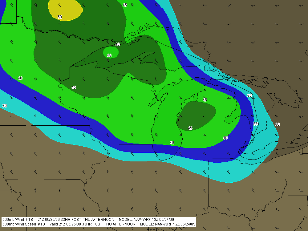
Unfortunately–or fortunately, depending on your point of view–all that lovely moisture has been wasted on insipid lapse rates and humdrum wind fields. What can you do with 500 mb winds of 25 knots or less? Answer: not much.

So what’s with that red dot in Wisconsin in yesterday’s storm reports? Not only did a tornado occur near the town of Cambria, but from the looks of the YouTube videos I saw, it was fairly impressive. Certainly those were more than momentary spin-ups which that Little Storm That Shouldn’t Have put down.

How on earth did it do that? There was nothing happening synoptically that suggested even a remote possibility of tornadoes. So when that puny cell across the lake from me went tornado-warned on GR3 yesterday, I just shrugged it off. Obviously a fluke, some weak Doppler-detected rotation, signifying nothing.

Just goes to show how Mother Nature can mess with your head. According to the NWS office in Milwaukee, that little stinker put down a tornado that lasted 14 minutes, traveled four miles, and did EF1 damage. The level 2 velocity couplet on it was unmistakable. Here’s the full writeup by KMKX, complete with radar images and a photo of the storm right after the tornado had lifted.

Storm chaser Scott Weberpal speculated on Stormtrack that there may have been some kind of interaction between an outflow boundary left by earlier convection. I can’t imagine any better explanation for why what should have been a pussycat of a pulse-type summer storm turned into a barn wrecker. Had the storm gone tornadic farther east, the lake breeze might have been suspect, but the cell was well inland from Lake Michigan.

Today I noticed a couple storms over in the Flint area displaying weak rotation on the radar, and one of them took on that telltale supercellular shape. Given the anemic upper winds, I’d normally have instantly written them off, but after yesterday…well, I watched and wondered, not expecting anything and therefore not disappointed when nothing happened, but still curious. What might happen if any cells firing in that vicinity moved into the Huron lake breeze zone, where the veering surface winds were liable to back?

As it turns out, the storms behaved the way you’d have expected them to given their environment. The last of the line is presently moving through southeast Michigan. But dewpoints are still in the low 70s, and a few popcorn cells are sprinkling the radar. Through my sliding glass door, I can see a big, mushy tower making its debut. Think I’ll grab my saxophone and camera and head out to get some practice in. With a little luck, maybe I’ll get a few lightning photos as a bonus.

The Lake Breeze Zone and Severe Weather

Earlier today, I opened up GR3 just out of curiosity and noticed some blobs of convection along the Lake Michigan shore by Chicago. Here are a couple radar grabs.

lake-breeze

lake-breeze1

These images interest me for several reasons, all of which have to do with a Great Lakes phenomenon called the lake breeze zone. The lake breeze zone is not a fixed area. Its boundaries are atmospheric, not geographic.

And boundaries truly are what it’s all about. Probably the most immediately noticeable feature on these radar images, besides the obvious storms, is the north-south boundary set up by the onshore breeze. It’s a great point of convergence where overall westerly surface winds butt up against backing winds from off the big lake. You can see how outflow from the storms that have fired up within the lake breeze zone interacts with the lake breeze boundary.

Another less immediately obvious by-product of the lake breeze zone is helicity. Notice how the wind barbs farther inland are all westerly, but inside the lake breeze zone, they’re easterly. Now, I’m no expert on this stuff, but I know enough to recognize the potential for localized helicity to occur even when the large-scale flow is unidirectional. During the day, strong thunderstorms can go tornadic when they encounter a backing onshore breeze near Chicago, along the Wisconsin shoreline, and along the Lake Huron and Lake Erie shores of eastern Michigan. The same can happen in the evening along Michigan’s western coast as the land cools and an offshore breeze prevails. Many times I’ve noticed the NAM and RUC showing a small sigtor centerered over Berrien County when there are no sigtors anywhere else in the region, and I’m sure this phenomenon is largely due to the lake breeze in that area.

Right now I see storms firing up farther north around Gladwin and Roscommon.

storms

A glance at the Gaylord VWP shows west winds neatly stacked from the surface on up. But look at the METARs along Lake Huron. Without much in the way of bulk shear, the storms are subsevere, just little popcorn cells. But it will nevertheless be interesting to see what comes of them as they work their way into those backed shoreline winds. You just never know.

The Summer Pattern Is Setting In

The SPC has placed Michigan and the Great Lakes in a slight risk area for tomorrow. But tornadoes aren’t in the picture. The summer pattern appears to be setting in, with the jet stream moving its headquarters to the US/Canadian border. As far as Michigan is concerned, that’s close enough that we can still expect some decent kinematics here and there. But what we get tends to result in linear MCSs more than supercells and the like.

Tomorrow’s SBCAPE should settle in between 2,500 and 3,000 j/kg, with dewpoints in the 70s. That’s certainly an ample supply of convective fuel. And F5 Data shows this for H5 wind speeds at 21Z:

If you can live with northwest flow, that’s not bad. But of course, the underlying winds are all westerly. Once again, Michigan’s energy will get sabotaged by unidirectional winds. How pathetically par for the course! Maybe we’ll get some supercells, but we’re unlikely to see the low-level helicity needed to make them tornado producers. Probably better knock on wood when I say that, because the lake breeze zone can do some funny things with locally backed winds. Overall, though, I think the order of the day will be some nice, burly, ouflowish thunderstorms.

What do I know, though? I’m still pretty green as a forecaster, and I recall a couple years ago when the models showed a unidirectional setup with nothing in the way of helicities, and an F3 tornado ripped through Potterville.

One of the nice things about living in Michigan this time of year–among the many wonderful advantages of this beautiful state–is that we’re prone to get a couple supercellular events when the traditional Tornado Alley of the Great Plains simmers under a titanium cap. Those occasions aren’t anything you can count on, but it’s nice when they happen–for me and my fellow storm chasers, anyway. I suppose other folks here might see things a bit differently.