A World-Class Sax for a Working Musician’s Budget
[NOTE: To see photos, click the links starting in the second paragraph. For whatever reason, I can’t embed images properly in this post.]
This is twice now that I’ve bought a saxophone online, sight unseen, from Phil Barone and twice that I’ve been delighted. Glowing reviews were part of what informed me when I ordered my tenor from Phil a year ago in November; the rest was previous experience. Three years prior I had purchased one of his soprano saxes and was impressed by its quality. I never thought I’d be able to afford another soprano the caliber of the Yamaha purple-label YSS-62 I had owned since the 1980s and was forced to sell in 2016. But the soprano I bought from Phil actually surpasses that sax, and for half of what I could have expected to pay. You can read my review of it here.
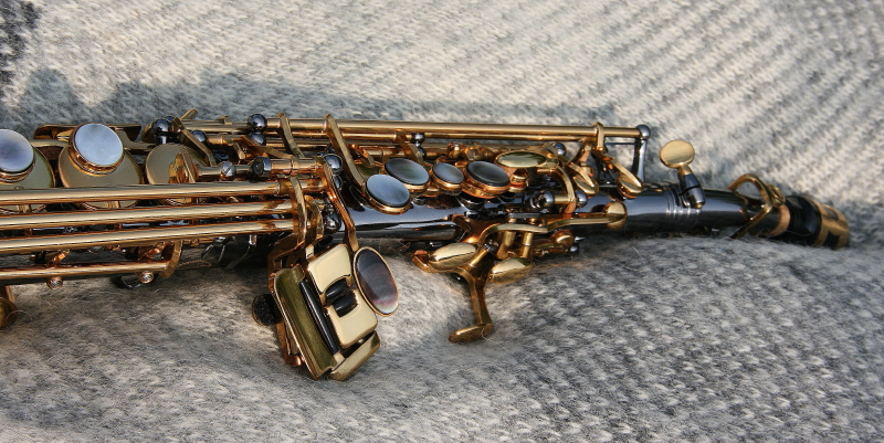
Phil offers two tenor models, classic and vintage, in a variety of finishes. Since a number of reviewers likened the classic version to the celebrated Selmer Mark VI, that’s what I chose. Not that I have any experience with the Mark VI; I know it solely by its reputation. The only tenor I’ve ever owned priorly is an ancient Conn with a huge tone but a clunky mechanism, which I put in mothballs long ago after a guy I lent it to returned it unplayable. So while I’ve read of players who sold their Selmers, Yamahas, and other high-profile horns after purchasing their Barone, I can’t make any comparisons. I can only say what I’ve already said: I love this tenor. And I can certainly tell you why.
START WITH THE SOUND
Phil’s saxophones come with two mouthpieces. One is the stock mouthpiece supplied, presumably, by his manufacturer in Taiwan. The other is one of Phil’s own custom hard-rubber mouthpieces, a $250 value in itself.[1] At the time of my purchase last year, Phil had no mouthpieces in stock and was in fact in the process of folding his business—a decision which, thankfully, he has since rescinded. But not to worry, Phil told me. He’d craft me a mouthpiece; just be patient. So the horn arrived with only the stock mouthpiece and a promise which, while it took a little time, Phil delivered on. Meanwhile, wanting to play the horn and being skeptical of stock mouthpieces, I shelled out thirty bucks for a Yamaha 4C to tide me over. It served, but it was far from ideal.
Then one day I opened my mailbox, and there it was—a brand-new New York #7 mouthpiece, shipped in a sturdy plastic protective case. After determining that numbers 3½ and 3 Java Green reeds were too stiff a matchup, I picked up a box of 2½s, slapped one on the piece, blew . . . and oh my gosh. The response. The sound. The bottom notes, warm, resonant, and effortless. The mid-range, full and consistent. The upper notes, crisp, with the edge I’d hoped for. The overall intonation, great. WOW! With my optimal mouthpiece/reed combination finally in place, the horn achieved its potential, and I was blown away.
Now, if I sound a bit effusive, remember, I was, and still am, new to playing tenor sax. One thing, however, was immediately apparent to me, and that was, I had landed a quality instrument. Phil’s goal is to make world-class saxophones available to players who don’t have a world-class budget. He accomplishes this by selling direct-to-consumer, eschewing retail markups and advertising costs. When you order a Barone saxophone, you deal with Phil in person. You talk, he listens, he advises, and he takes pride in giving you a good, a really good, deal.
I’ll add that a while later I also had the good fortune to obtain an older metal piece of Phil’s from my friend Jeff Dowell. Jeff is an unalloyed and persuasive Barone evangelist who owns several of Phil’s saxes, including a bari, and his enthusiasm for them factored into my earlier purchase of my soprano. A few months ago Jeff offered to sell me a Barone #8 tenor mouthpiece. It didn’t resemble anything in Phil’s present lineup, and it showed the signs of wear one could expect, but it passed the pop test just fine. I tried it for a couple weeks, liked its extra edginess and effortless response, and bought it. I now have two of Phil’s mouthpieces. Which do I like best? The one I’m playing; it depends on my mood.
SILKY-SMOOTH MECHANISM AND BEAUTIFUL APPEARANCE
My hands aren’t huge, just an average sort of big, with long fingers. The sax’s ergonomics feel custom made for me. The keys lie comfortably and precisely under my fingers. In particular, the linked low-register plates are remarkably nimble, much easier to get around on than I’m used to with my beloved Conn 6M alto. Maybe that’s also a trait of the Mark VI, to which, as I’ve mentioned, this horn has been favorably compared. Whatever the case, I find myself loving to dip into the bottom end. That’s something new for me—not that I’m averse to prowling around there on my other horns, but this one puts out the red carpet for my left pinky.
There’s a lot of metal in this sax, and I like that. My Conn alto is the same way; there’s a feeling of solidity to it that makes lighter horns feel flimsy to me. That’s not a criticism of other saxes, just my subjective impression, but I think the extra brass in both instruments surely contributes to their sound.
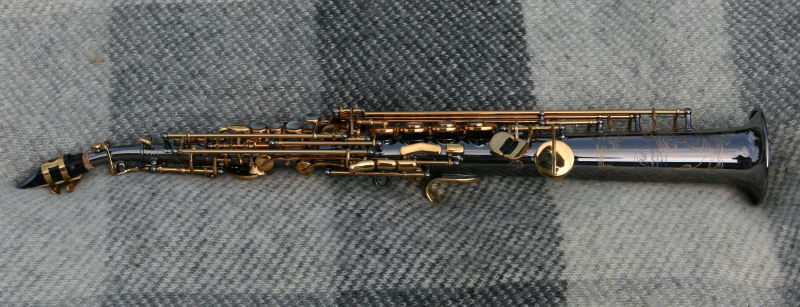
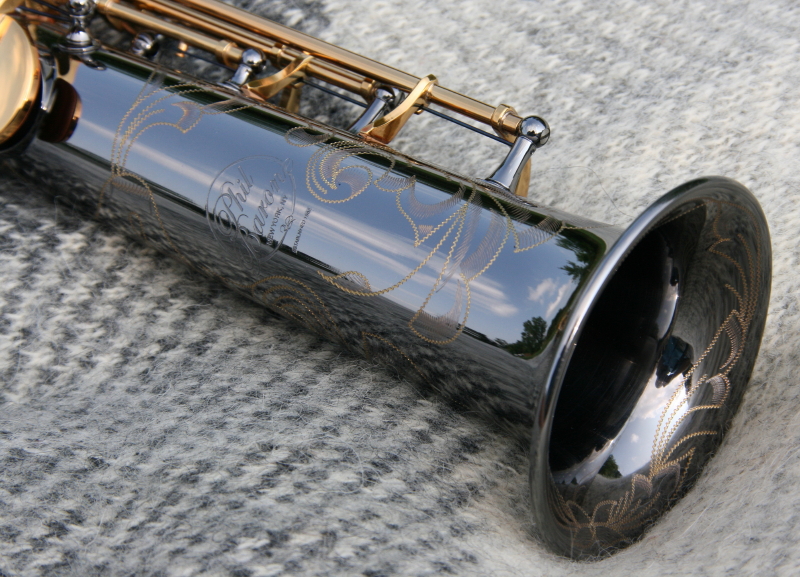
On top of that, this tenor is gorgeous. My soprano has a black nickel plating with gold engraving, but for whatever reason, I felt drawn to the vintage bare brass for my tenor. Something about the richly patterned raw metal with its antique-looking patina attracted me more than a shiny finish. There’s an almost iridescent luster to it that’s quite lovely. One caveat: the bare brass requires conscientious care to avoid spotting, more so than with plating. If you order this finish, make sure you wipe it down with a soft cloth after each use to remove moisture and the acid left by your hands. I suppose that’s just common sense, but I learned the importance of good horn hygiene by failing to practice it until my negligence began to show. A friend of mine with long experience in metalworking advised me to treat the horn with Renaissance Wax. I did so with all my saxes, and I’m now consistent about cleaning their interiors and wiping their surfaces when I’m done playing them.
RUGGED AND ATTRACTIVE CASE
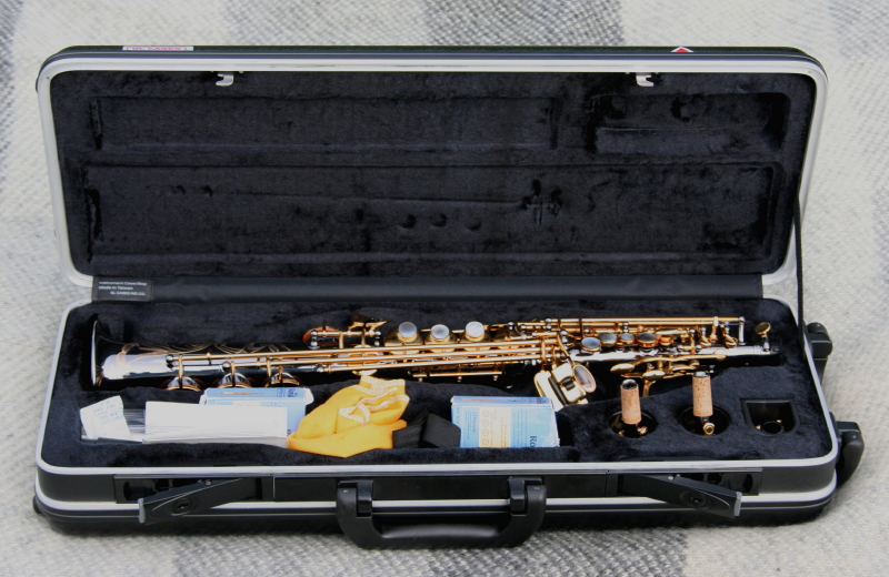
After looking at saxophone cases online, I’m struck by the range of prices. You can purchase a tenor case for less than $100 or more than $600. A reasonable starting price for a decent case seems to be around $150. The case my tenor came in—a tough, well-made black ABS hardshell with a contoured interior—compares favorably with the BAM Cabine case, though it’s not sculpted like the BAM. The Cabine sells for around $430; Phil’s site doesn’t state the value of his case, but I’d imagine $300 is a safe and probably conservative bet.
The sax fits in the case snugly—no jostling around—and four latches ensure tight and secure closure. When you first open the case upon receiving your shipment, you’ll find that the saxophone’s keys are all firmly clamped in place to guarantee the pads stay properly seated and the mechanisms remain unaffected by shipping and handling.
Look inside the small compartment at the bottom of the case and you’ll find
- two mouthpieces, as mentioned earlier: the stock piece and the Barone hard-rubber mouthpiece of your choice
- a soft cloth for wiping down your horn
- a shoulder strap for easy, hands-free carrying
- a padded neckstrap
There are limitations to what the compartment will accommodate, but it holds everything I need: a box of reeds and a reed holder, my two Barone mouthpieces, cork grease, and cleaning cloths for the insides of the neck and sax body. I replaced the neckstrap that came with the horn with a Neotech, which I put in the bell of the horn, and I’ve taken to placing the wipe-down cloth on top of it, though it fits just fine in the compartment.
SUMMING IT UP
I’ve written this review on my own initiative, unsolicited and uncompensated by Phil Barone. My motive is simple: to provide a service to you, my readers, and to give an attaboy to Phil, who surely deserves one.
There are plenty of great saxophones available today, and you can spend as much as you want to obtain one. But you don’t have to kill your budget to get a killer horn. Phil Barone’s mission, as stated on his website’s About page, is to provide players like me with “a professional quality saxophone priced for the student; an instrument that doesn’t just rival the sound of more expensive brands, but out-plays them time and time again.”
Again, I have no grounds for comparing my Barone tenor with other saxophones, but there are scores of endorsements to confirm that Phil’s product lives up to his words. The one thing I can attest to myself is what I’ve already said twice, and three is the charm: I’m in love with this horn.
[1] Your choice of tip opening and either Vintage or SoundMaster mouthpiece.