Stormhorn.com Returns: A Modest But Happy Summary of The Year’s Storm Chases

Wow! More than a year has passed since I’ve posted in this blog. So much has happened, some of which amounts to a veritable sea change in my life. But I’m not going to get into that here. Relevant for Stormhorn.com is this: the site’s URLs, which acquired an unwarranted and unwanted prefix when I was forced to switch from my superb but now defunct former webhost to Bluehost, are now fixed, and this blog is properly searchable and functional again.* Already, in just a couple days, I’ve seen three sales of my book The Giant Steps Scratchpad, and hopefully this site can once again gain some traction as both a jazz saxophone resource and a chronicle of my obsession with storm chasing.

As the dust began to settle from a painful but beneficial transition, I found myself with the wherewithal to finally chase a bit more productively and independently than I have in a long time. It felt wonderful—wonderful!—to hit the Great Plains again in a vehicle that is trustworthy, economical, and comfortable for driving long distances. Kansas, Nebraska, South Dakota—hello, old friends. It was so good to see you again at last, such a gift to drive your highways and take in your far-reaching landscapes . . . and yes, to exult in your storms, your wild convection that transforms your skies into battlegrounds of formidable beauty.

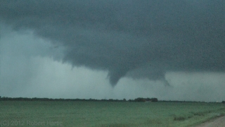
It is a long drive from Michigan to tornado alley, eight hundred miles or more just to get to the front door. Ironically, I could have spared myself most of my first trip. It landed me in Wichita overnight, then on to chase the next day in southwest Kansas and northeastward almost to Salina. No tornadoes, though. They were there, all right, but I was out of position and uninclined to punch through a bunch of high-precip, megahail crud along the warm front in order to intercept potent-looking (on the radar) but low-visibility mesocyclones. Two days later, though, on May 20 in northwest Indiana on my way back home, the warm front was exactly the place to be, and I filmed a small but beautiful tornado south of Wolcott. It was my one confirmed tornado of the year.

A few weeks later I hit the northern plains with my friend Jim Daniels, a retired meteorologist from Grand Junction, Colorado. It was his first chase, and for me, one of the blessings, besides the good fellowship and opportunity to build our new friendship, was introducing someone to chasing who already had his conceptual toolkit assembled. No need to explain how a thunderstorm works or how to interpret radar—Jim’s a pro; I just handed him my laptop, let him explore the tools, and we were ready to rumble.

Except—no tornadoes.

Then came August and a shot at severe weather right here in Michigan. I tagged along with a slow-moving, cyclic, lowtop supercell with classic features through the western thumb area of the state. It was nicely positioned as tail-end Charlie, sucking in the good energy unimpeded. A little more instability and it could have been a bruiser. As it was, it cycled down to the point where I thought it was toast, just a green blob on GR3, at which point, faced with a long drive home, I gave up the chase. Naturally the green blob powered back up and then spun up a weak twister ten or fifteen minutes later.

I didn’t mind missing the tornado. Well, not much. I had chased about fifty miles from Chesaning to south of Mayville, about two and a quarter hours, and gotten plenty of show for my money—rapidly rotating wall clouds, a funnel or two, and some really sweet structure of the kind you rarely see in Michigan. Then on the way back, as a cold front swept in, the sunset sky was spectacular.

Waterspout season has also come and gone, and I hit the lakeshore a number of times. One of those times was fruitful, and I captured some images of a couple picturesque waterspouts out at Holland Beach. They were all the more interesting because they occurred southwest of a clearly defined mesocyclone. But I’ll save that and a pic or two for a different post. It deserves a more detailed account, don’t you agree?

Stormhorn.com is about jazz saxophone and improvisation as well as storm chasing. So if jazz is your preferred topic, stay tuned. It’ll be comin’ at ya. Got a few patterns and licks to throw at you that I think you’ll enjoy.

That’s all for now. Stormhorn.com is back in the race.


____________________

* The one exception is the photo gallery. Photos in individual posts work fine, but the links on the photos page don’t work.

Also, formatting is messed up in the text of a lot of older posts. So I still have some issues to work through with BlueHost. I’ll probably have to pay to get the image gallery working right again; hopefully not so with the formatting stuff.
Waterspout Season Opens Today on Lake Michigan

When I saw the clouds this afternoon, I couldn’t help but wonder. Lisa and I were catching a late lunch–or an early dinner, take your pick–at the Fire Rock Grille, and I was staring out the window over the golf course at low-topped convective towers to my northwest. The sky had that look about it that spoke of stripped-out moisture and cold mid-level temperatures, as you begin to expect around this time of year, and I thought, “If those towers were over Lake Michigan, there’d be a waterspout hanging from one of them.”

My first successful waterspout chase last year led me to believe that when conditions are right for spouts–when cold air moving over warm lake waters creates steep low-level lapse rates and enough vorticity is present to get stretched by an updraft–then the main thing to do is get one’s butt down to the lakeshore and look for convective bands. Maybe I’m being overly simplistic; regardless, September 22, 2012, made me a believer in the feasibility of viewing Lake Michigan waterspouts. I even managed to get some shaky but very cool video that day of a spout making landfall about one hundred yards north of me.

My instincts today proved right, but the action occurred on the other side of the pond, where some spectacular photos and video came from lucky beachcombers in Kenosha, Wisconsin. I normally avoid embedding YouTube videos in my posts because I never know how long one will remain viable, but I’m displaying this one by Jeff Magno because I find it particularly intriguing.

Not only is the distant spout massive at this point, but look at how the mist rising off of the sidewalk in the foreground forms a tracer for the surface winds. The mist rushes southward, consistent with today’s northerly flow, but where it rises, you can see it begin to move lakeward. It dissipates far too quickly to tell much of a story, but it leads me to speculate about the low-level vertical vorticity that may have been available to produce the spouts.

But then, what do I know about these things? I’m just a happy observer when I get the chance to be one–which, as it turns out, may be tomorrow morning. Got a hot tip on that, so I’m setting my clock and planning to wake up early, and tonight I will dream of near-shore convection.

Why I Chase Storms: A Storm Chaser’s Manifesto

I posted the following message on Facebook, but it really belongs here. It is one of what I think will be a number of very personal, reflective posts on storm chasing as I process the impact of a difficult, disappointing, terrible, and tragic season.

——————————

This storm season has left me feeling very torn. As I sift through its impact on me, I am grateful for my friends who are NOT chasers. People whose perspective on life is different from mine. My men’s group, for instance, is a small circle of wonderful, godly brothers in Christ who have seen plenty of life. It felt cathartic to share with them last night about my passion for chasing storms, my sense of failure as a chaser, and the recent, tragic losses of Tim and Paul Samaras and Carl Young.

In talking with the guys about chasing, I spoke frankly about a common misconception about storm chasers: that we are out there saving lives by what we do. That may sometimes be the case, but it is not the motivating force for me or any of the chasers I know. That image, fostered by the media, simply isn’t what drives chasers. I chase, and most other chasers chase, primarily because we are enamored with the storms. There is nothing intrinsically heroic in what we do. Depending on where we’re chasing, our presence in the field can be valuable as part–and only a part–of warning the public. A few chasers–a very few, including the late Tim Samaras–collect data for scientific research, some of which could conceivably help to improve an already excellent warning system. Occasionally, some chasers find themselves in a position to make a life-saving difference as first responders. And Storm Assist is providing a fabulous means for chasers to contribute their videos to a charitable cause whose proceeds go directly to aiding the victims of tornadoes and severe weather.

All of these things are true and good. But they’re different from the myths that have arisen around storm chasing. One of those myths is that chasers are sickos who enjoy watching homes and communities get trashed; the other is that we’re more noble than we really are. Between these two extremes lies the reality of why storm chasers actually chase. And the truth is, no single reason fully describes every chaser. Chasers are individuals, and today as never before, that individual component interacts with the influence of technology and the media to create a complex and varied mix of motives.

Yet I believe all chasers possess one common denominator: a love for, a passion for, the storms. Personally, storm chasing engages me on many levels–intellectual, emotional, spiritual, aesthetic, creative, and adventurous–in a way that nothing else does. When I can chase the way I want to, I feel alive; when I cannot, which is far too often, I feel intensely frustrated, moreso than I think is healthy. Lately, my limitations have left me feeling depressed. That is something I have to work through, talk to God about, and discuss with those close to me who know me well.

But one thing is certain: I chase, as best I am able, because it is what I love to do, period. There is nothing else like storm chasing. I love the sky, the storms, their drama and beauty, their intensity, their mind-boggling motion, the awe they inspire, the landscapes they traverse, and the lessons they have to teach. I am a pupil of the atmosphere.

Because I live in a part of the country where both tornadoes and experienced chasers are far fewer than in the Great Plains, I can perhaps play a more significant role locally in helping to warn the public than in Tornado Alley, where droves of chasers line the roads. Chasing for WOOD TV8 here in West Michigan creates that possibility for me.

But I would chase regardless. It’s what I do, just as playing the saxophone is what I do and just as golfing, or car racing, or writing, or painting, or fishing, or crocheting, or hiking, or hunting, or what have you, is what you do. We’re all wired to do something, and we desire to do it excellently. There’s nothing innately noble about it, and there doesn’t need to be. Your pursuit may, in the right circumstances, put you in a position to contribute to the well-being of others. But it needs no justification in order to be worthwhile.

That is how I view storm chasing, and I think many of my fellow chasers would agree.

So please do not thank me for what it is I do, for the only thing I am doing is following my heart. In the same breath, please do not condemn me for it, for you may benefit from it someday–again, as just one facet of an excellent warning system in which I play only a part.

Remembering the Henryville EF4 Tornado: A One-Year Retrospective

We were three-and-a-half miles north of Palmyra, Indiana, when the tornado crossed the road less than a mile in front of us at Dutch Creek Road, ripping up a 12 x 12-foot section of asphalt in the process and throwing it in chunks into an adjacent field. Within about a minute, the vortex had morphed from a wispy rope into a powerhouse of a stovepipe, tearing tangentially across our path as Bill Oosterbaan and I blasted north on State Road 135.

Bill is no timid driver, and he did a heck of a job keeping pace with the beast. But the storm was a missile, moving at least 60 miles an hour, and once we hit downed power lines at Dutch Creek Road, we had to let it go. We had no idea of the tragedy it was about to inflict to our northeast. But, watching the white condensation funnel billow and intensify beyond the treeline, with secondary vortices wrapping around it like a cloak, we could tell it was a monster. As I filed a report on Spotter Network, Bill turned around and headed back south. A second supercell was hot on the heels of the one we had just let go, and repositioning became our immediate concern.

Bill and I had just been fortunate to catch and videotape the Henryille EF4 tornado in its formative stages. We first glimpsed it south of Palmyra as it descended from a wall cloud several miles to our west-northwest. It didn’t look particularly impressive at that point, but as we closed in, the fast-moving circulation began to display wild shapes and motions, then condensed fully and finally just before crossing the highway.

It seems incredible that  in the few meager seconds the tornado took to translate across SR 135, it managed to rip up a large section of road. The term “asphalt scouring” just doesn’t apply; there was no scouring involved. An estimated 10,000 pounds of pavement got literally torn from the downwind side of the highway and thrown something like one hundred feet. I didn’t witness this road damage and only found out about it later. But chaser Simon Brewer provides a good description of what he saw just a few-score yards north of where Bill and I turned around.

The wider damage path associated with the main tornado circulation was easily visible from a forest west of the highway through a field, and past the highway through another forest to the east. Also, an individual suction vortex damage path was easily found starting in the field scouring vegetation and tossing boulders from a drainage ditch, then crossing a section of highway peeling and tossing massive slabs of asphalt, the largest broke upon second contact with the ground (it bounced leaving an significant impact crater) on the downwind side of the highway. Typical sphalt scouring is usually associated with EF3 and stronger tornadoes, but typical asphalt scouring is found on rural roads with relatively thin asphalt 1-2 inches or less thick. It’s amazing to think how short a time period the small suction vortex was probably over that section of highway; maybe only a second tops! I usually don’t stop to investigate tornado damage, but when I saw the highway damage on March 2nd I was blown away! I took more photos of the road damage than I did the storm and tornado. I consulted Dr. Greg Forbes and he agreed this was one of the most incredible damage cases he’s heard, only possibly being eclipsed by the trench created by the Philadelphia MS EF5 on April 27, 2011.*

A year has passed since all of the above took place. At the same time last year as I am presently writing these words, Bill and I were nearing Louisville, and within another hour or so we would shift into chase mode, head west, and intercept our storm. Click here to read my complete account of that chase, including my video of the tornado as well as radar images and skew-Ts.

Today the weather is drastically different. This March is behaving like March, not May, and in light of last year’s prolonged heat wave and disastrous drought, I am glad. I will be delighted to see another round or two of good winter weather bring still more moisture to the Plains and Midwest and prime the pump for storm season. The storms of spring will get here soon enough, and while nothing is certain, my hunch is that this year will be better than last year.

_______________

* Simon Brewer, from his January 14, 2013, post in the Stormtrack thread The EF Scale and Asphalt Scouring Caused by the March 2 Henryville Tornado. Also see Simon’s and Jim Bishop’s chase account, which includes photos of the road damage, at their Stormgasm website. You can see Dutch Creek Road just past the road sign and parked car in the background of the first photo.

Christmas Day Severe Weather and Tornadoes in Dixie Alley

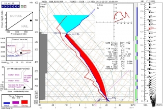
I hadn’t planned to post today, but with the severe weather that the NWS has been forecasting for several days now already underway in east Texas and conditions ripening across southern Dixie Alley from lower Louisiana into Alabama, I thought I’d pin a few of today’s 12Z NAM forecast soundings to the wall to let you see what the squawk is about. I’m focusing on Louisiana because it seems to me that, from a storm chasing perspective, that’s where the best chances are for daylight viewing–not that I think there will be a whole lot of people chasing down in the woods and swamps on Christmas, but I need some kind of focus for this large and rapidly evolving event. Remember, the sun sets early this time of year.

To summarize the situation, a vigorous trough is digging through the South, overlaying the moist sector ahead of an advancing cold front with diffluence across Louisiana, Mississippi, and Alabama. Shear and helicity are more than adequate for supercells and strong tornadoes, with forecast winds in excess of 100 knots at 300 millibars, 80 at 500, and 45-50 at 850, ramping up to 60 at night per the Baton Rouge NAM.

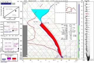
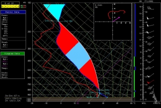
I’ll start with three soundings in southwest Louisiana at Lake Charles. It’s obviously a potent-looking skew-T and hodograph, with over 1,600 J/kg SBCAPE and more-than-ample helicity. No need for me to go into detail as I’ve displayed parameters that should be self-explanatory; just click on the image and look at the table beneath the hodograph.

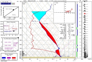
What I do find noteworthy is the very moist nature of this sounding, suggestive of overall cloudy conditions and HP storms. This changes quickly around 20Z (second image), with much drier air intruding into the mid-levels.

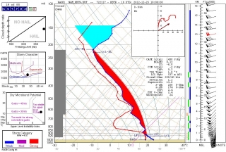
From there on, temperatures at around 700 mbs begin to warm up until by 23Z (third image) they’ve risen from 1.5 degrees C (18Z) to 5.9–a gain of nearly 4.5 degrees–and a slight cap has formed and becomes strong by the 00Z sounding (not shown). Note how the surface winds have veered, killing helicity as the cold front moves in. End of show for Lake Charles.

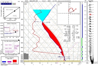
Farther east in the Louisiana panhandle, you get much the same story at Baton Rouge, except the more potent dynamics appear later and more dramatically, with 1 km helicity getting downright crazy. I’ve shown two soundings here. The first, at 18Z, has a dry bulge at the mid-levels but moistens above 650 mbs, and by 20Z (not shown) it has become even moister than its Lake Charles counterpart, to the point of 100 percent saturation between 600 and 800 mbs. Helicities are serviceable but less impressive than to the west.

There’s a big change in the second sounding, this one for 00Z. The dewpoint line sweeps way out, and look at that wind profile! With a 60 kt low-level jet, helicities are no longer also-rans to the Lake Charles sounding; at over 500 m2/s2, they’re hulkingly tornadic, and the sigtor is approaching 13.

Mississippi is obviously also under fire, and I hope the folks in Alabama have taken the 2011 season to heart and purchased weather radios that can sound the alert at night.

To those of you who chase today’s setup–and I know there are a few of you who are down there–I wish you safe chasing. But my greater concern is for

the residents of Dixie Alley who live in harm’s way and aren’t as weather-savvy, and some of who–despite the NWS’s best efforts–may not be aware of what is heading their way this Christmas Day.

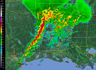
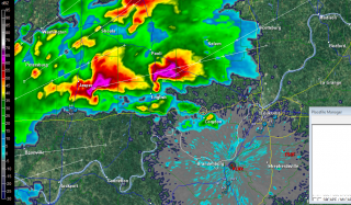
Having just glanced at the radar, I see that the squall line is now fully in play. I’ll leave you with a screen grab of the reflectivity taken at 1725Z.

Have a blessed and safe Christmas.

ADDENDUM: In watching the radar, it’s obvious that the 12Z NAM was slow by an hour or so. Can’t have perfection, I guess.

An Active Weather Pattern Moving In

These next few days look interesting severe-weatherwise from the northern Plains into the Great Lakes. Today holds the potential for a significant blow near the Missouri River in South Dakota, Minnesota, Nebraska, and Iowa. Here is a RAP forecast sounding for Sioux Falls, SD, for 00z tonight.

I’ve been eyeballing that area via the NAM for a number of runs. Capping has been an issue for a while now, but NAM has consistently wanted to break the cap in the area I’ve mentioned. If I could have found a partner to split costs, I’d have left last night, but the thought of going it alone and blowing a wad of cash on a cap bust–a distinct possibility, with 700 mb temps hovering AOA 12 degrees C–spooked me.

Now I think I should have taken the risk. Today could be another Bowdle day, and I wish I was in Sioux Falls right now. Some of the  indices there for this afternoon look pretty compelling, at least if the RAP is on the money. The cap could break between 22-23z, and if that happens, then walloping instability (mean-layer nearly 3,900 J/kg CAPE and -10 LI) and mid-70-degree F surface dewpoints will surge upward into explosive development, and ample helicity will do the rest.

However, the SPC is not nearly so bullish as the above sounding, citing the complexity of the forecast due to capping and the lack of dynamic forcing. That’s been a repeated theme. Today looks like one of those all-or-nothing scenarios where chasers will either broil in a wet sauna under merciless blue skies or have one heck of an evening.

Boom or bust for those  who are out there. As for me, this evening I will either be watching the radar and beating my head against the wall or else congratulating myself on my good fortune for not going.

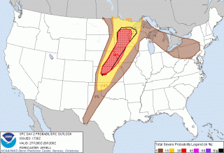
But I’ll also be packing my gear in preparation for tomorrow, and later tonight I’ll be hitting the road with Bill and Tom. I’m uncertain what Sunday holds, but last I looked, the dryline by the Kansas-Nebraska border looked like a possibility on both the NAM and GFS. The weak link seems to be the dewpoint depression; it’s wider than one could hope for, suggesting, as the SPC mentions in its Day 2 Outlook, higher LCLs. I haven’t gone more in depth. We’ll look at the model runs again tonight and pick a preliminary target for tomorrow.

Photos from the April 14, 2012, Kansas Tornado Outbreak

May has been an astonishingly idle month for chasing storms, at least from the standpoint of a Michigan-based chaser who can’t afford to travel a thousand miles to tornado alley on every whim and wish of a slight-risk day. So tonight I finally got around to capturing a few still images from my video of the April 14, 2012, tornadoes in Kansas. Please excuse the graininess. These are, after all, video grabs, and the original footage was shot right around and after sunset. So … not high quality, but great memories of an exciting and rewarding chase day. You can read my written account of it here.

April 13-14 Oklahoma-Kansas Chase

This post is long overdue, but there has been no helping the time lapse between my first Great Plains chase of the year on April 13-14 and tonight, when I’m finally setting the highlights of those days briefly in print. The reason is that, upon my return home, I immediately succumbed to the worst case of acute bronchitis I’ve ever experienced. It was characterized by constant, deep, wrenching, non-productive coughing; a chronic sore throat; a fever that topped 102 degrees; an ear infection; laryngitis; plugged-up sinuses; and if I’ve missed anything else, let me just sum it all up by saying that I was in neither the condition nor the mood to do any film editing or writing, or much of anything except to attach my face to a vaporizer and to suck down Jell-O, chicken soup, sports drinks, ginger tea, and enough fluids overall to qualify me as a human aquarium.

Today, though, I am definitely on the mend, and it’s high time I got this report written. Tomorrow looks to be another big day in eastern Kansas, so I need to write before anything I have to say about an event from two weeks ago gets swallowed up in the latest round of wedges.

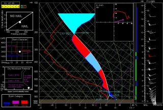
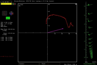
And it does look there could be some wedges. Look at this NAM skew-T and hodograph for Chanute, Kansas, at 00Z. (Thanks, Ben Holcomb, for tipping me off to Chanute!) With 1km and 3km SRH at 290 and 461 m2/s2 respectively and a nice, fat low-level CAPE, that’s the broth for some violent

tornadoes. I expect that part of the area that the SPC has categorized as a light risk for tomorrow will be upgraded.

But I’m chasing rabbits. Getting back to the topic of this post: With conditions coming together for two or three days of severe weather in tornado alley from April 13-15, Bill Oosterbaan and I headed for Oklahoma in company with two new chaser friends. Rob Forry is a fellow chaser from the other side of Michigan who had yet to experience a Great Plains chase; and Steve Barclift is an editor friend of mine who, I discovered, shares my keen interest in severe weather and had been wanting to get a feel for storm chasing.

We arrived in Norman, Oklahoma, late in the morning on Friday the 13th. Dropping off our travel bags at the apartment of Ben Holcomb, who was graciously putting us up for the night later on, we promptly headed out for the chase.

We encountered our first storm of the day not far from Chickasha. Not being the superstitious type, I have no qualms about chasing storms on Friday the 13th; still, this storm gave us a shake when it led us back to Norman and spun a tornado within a mile of Ben’s apartment. We pulled out of chase mode long enough to make sure that Ben’s place was okay. Then we headed southwest a second time, this time plunging beyond Chickasha toward Boone and Meers, and thence into the heart of the Wichita Mountains. There, we positioned ourselves on the southeast flank of a tornadic supercell as it advanced slowly over the ragged landscape.

We may have witnessed a tornado at this point, but my video provides no conclusive evidence, just strong suggestions. Tornado or not, though, to stand in the inflow of that massive, beautifully crafted supercell and watch it spew lightning from its charcoal interior as it dragged across those prehistoric peaks was reward enough. No more need be said, nor shall be, since Friday was simply a scenic prelude to the action up in Kansas the following day.

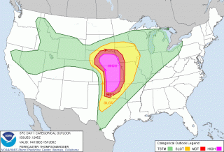
Saturday, April 14, dawned on a large high-risk region that ranged from most of central and eastern Nebraska south through central Kansas and down into much of central Oklahoma. With impressive upper- and mid-level jets overlaying the region, bulk shear was beyond adequate, as was instability. The ingredients were all there. Today, it seemed, would be one of those days when anyone who chased–and there were lots of chasers prowling the prairies on this day–would see a tornado.

In practice, though, it wasn’t quite that easy. Our plan was to drift up I-35 and then head west toward a likely looking storm. Not a very sophisticated approach, but it seemed likely to work, and in fact it did. We weren’t far across the Kansas border when we decided to turn west, and in a while we encountered our first supercell of the day, and with it, our first tornado. The cone spun at a good distance, probably five miles or more away. Looking at my video clip, I’m satisfied that it was indeed a tornado–even at that distance, the outline is distinct and separate from the storm’s rain shaft.

We stuck with our storm as it sailed north-northeastward, but it seemed to be having a hard time establishing itself beyond its first tornadic salvo. Still we stayed with it, hoping it would organize into a rumbling monster. But it continued to attenuate into a skinny, sorry-looking mongrel, so we finally dropped it for a more promising-looking storm to its south.

I remember saying at the time, “Dropping this storm [which I was in favor of doing] could be a really good decision. Then again, the storm could reorganize in half an hour and start putting down hoses.” Of course, the latter is what happened. Half an hour or forty-five minutes later, the storm we had put behind us had morphed into a supercell that, from the looks of it on radar, clearly wasn’t fooling around, and it went on to produce a string of tornadoes.

But by then we were committed to the storm to its south, a deceptively imposing-looking beast that washed out on us as we tangled with it and ultimately disappeared completely from the radar screen. Long before that happened, we wisely abandoned it for the next storm down the line, and as the saying goes, the third time was a charm. Just drawing closer to the storm environment, we could tell that this storm was of a different caliber. There was more lightning. The inflow was strong. The thing just felt tornadic. And it was.

From here on, I’ll let my video clip tell the story. It chronicles our chase from near Pretty Prairie, where we encountered our first tornado with this storm at close range with rain bands wrapping toward us, on north-northeastward toward Lost Springs and Delavan. The latter, night-time portion of the video is best viewed in dim light.

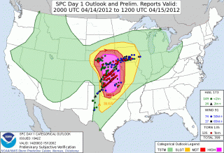
On a side note, the SPC did a great job of forecasting this widespread outbreak, as you can see from this verification of the outlooked areas with confirmed tornadoes. One thing that puzzles me is why they showed a 45 percent hatched area for Nebraska, when from what I recall, the NAM and RUC didn’t appear at all bullish for a northern play. At the time, I figured that those SPC guys must have known something that the models weren’t revealing, but in fact the majority of tornadoes occurred southward in Kansas. If anyone from the SPC happens to read this, I’d welcome your comments on the thinking behind the enhanced focus on Nebraska over regions southward.

We overnighted east of Kansas City, and the following day found us chasing a warm-front scenario in south central Minnesota. The setup this day was utterly unlike the previous day. In fact, with the surface low nearly collocated with a closed 500 mb low to our west, we were dealing with what seemed like a quasi-cold-core setup. The storms, low-topped supercells, formed in convective “streets” that moved nearly straight northward, each street progressively kicking off new convection to its east where outflow presumably converged with strong southeasterly surface winds. Tornado reports occurred to the north, along or just past the warm front, where winds backed strongly.

The setup was an interesting one particularly in that tornadoes were reported on the cold side of the front, which cooled markedly within a matter of a few miles. This seemed counterintuitive: what kind of surface instability was available in such an environment? I recalled my chase with Kurt Hulst and Dave Diehl back in February, 2006, when we watched a storm on the far eastern side of a cold core drop a tornado several miles to our south. Where we stood, the air was so cold that I could see my breath; yet across the distant treeline, an unmistakable tornado was spinning and doing damage in a small town east of Kansas City.

As for this present date, while the four of us didn’t see a tornado on April 15, we did see the most wildly circulating wall cloud I’ve ever laid eyes on. The motion in the thing was unreal, something I attribute to the storm’s crossing the warm front and encountering a radical backing of winds.

Inevitably, we found ourselves in Minneapolis, at which point we left chase mode and headed for home. The first few coughs that would rapidly blossom into the debilitating bronchitis I mentioned at the start of this post were just getting hold of me. The following day would mark the beginning of a miserable two weeks. I’m just glad the virus held off till I got home.

Now I’m almost recovered–not in enough time for what looks to be a lively day in Kansas tomorrow, but certainly for the next round after.

For another perspective and some absolutely stunning videos of the Kansas outbreak of April 14, visit my friend Kurt Hulst’s blogsite, Midwest Chasers.

Heading Home from Kansas

Bill Oosterbaan, Steve Barclift, Rob Forry, and I have had a fun time chasing low-top supercells today in Minnesota on our way home from two action-packed days in Oklahoma and Kansas. Now, at the end of day three, we’re heading east on I-94, with Minneapolis fresh behind our backs and seven hours of driving ahead of us.

The four of us witnessed several tornadoes–how many, it’s hard to say for sure, but we’ve agreed upon six–during yesterday’s massive outbreak. We tangled unsuccessfully with two supercells before hitting paydirt with a storm that dropped a string of swirlies around Hesston, Goessels, and points beyond. And yes, I shot some decent video, which I’ll post on YouTube once I’ve edited it, and also subsequently embed in a post here on Stormhorn.com. Consider this little placeholder to be a friendly heads-up that more is on the way in a day or two. Till then, ciao.

Tornado Weather Enters with 2012 Meteorological Spring

Today is the first day of meteorological spring, and while March is poised to come in like a lion, there may be nothing lamb-like about its exit. Not if these past few days and tomorrow’s setup are any indication of what to expect.

Tuesday saw 25 tornadoes in Nebraska, Kansas, Missouri, and Illinois, with several fatalities. Wednesday logged another ten in Indiana and Kentucky. Today is another light-risk day, and tomorrow the SPC has outlooked a large swath from southern Indiana and Ohio down through Kentucky and Tennessee to northern Mississippi and Alabama in a moderate risk.

Like most storm chasers, I’ve been watching this system for several days. Typical of early-season setups, it will be a dynamic system driven by crazy upper-level winds and a strong low-level jet overspreading weak to moderate instability. With this kind of setup, 500 J/kg CAPE can get the job done. But with storm motions this fast, intercepting them will be more like a skeet shoot than a chase.

Regardless, I expect to head out tomorrow for my first chase of the year. I’ve been casting my eyes on southeastern Indiana and southwestern Ohio, not far south of where the peak 500 mb jet energy will be nosing in. I notice that the latest NAM is a bit more conservative with instability, nudging it southward, so I guess the question is, how far south does one want to travel for this kind of fast-moving system? Probably not very. I don’t see the point of going after fast-moving storms in Kentucky or Tennessee in hilly, woodsy terrain that obscures the view. That’s a discussion point with Kurt and Bill, since the three of us will likely chase together.

This looks to be a dangerous situation across northern Dixie Alley. Crossing fingers and hoping for minimal impact on communities tomorrow afternoon into the night.