There’s nothing funny about finding yourself trapped at the end of a dead-end road with multiple tornadoes bearing down on you. It’s not a scenario one anticipates when heading out on a chase, but it’s the one my chase partners Bill and Tom Oosterbaan, Mike Kovalchick, and I found ourselves in, along with seven other vehicles full of chasers, last Saturday in South Dakota.
Up until the moment when the road we were on ended abruptly at the edge of a farmer’s field, we were simply performing a routine maneuver: select an escape route and take it when the storm draws near. We and the other chasers had chosen 130th Street east of CR9 as our best eastbound option. It looked good on both DeLorme Street Atlas and Microsoft Streets & Trips: a nice through road connecting with 353rd Avenue three miles away. It was a perfectly logical choice, and things would have proceeded without incident had the maps been accurate.
What the maps didn’t show was that a farmer had recently plowed over the road, converting it to a field. We made that delightful discovery two miles down. The road had already begun to degrade, presenting us with a couple mudholes which Mike’s Subaru Outback plowed through without a problem. But the field was a show stopper. Suddenly, poof! No road. On an ordinary day, this discovery would have been an inconvenience. With tornadoes breathing down our neck, it was horrifying.
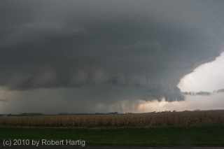
But I’m getting ahead of myself. Let me backpedal a bit to set the stage. After stopping to enjoy the eminently photogenic fourth tornado that followed the beastly Bowdle wedge (see previous post), the four of us headed north to CR2/125th St., then turned east. The storm was morphing into a high precipitation supercell (photo at top of page). We watched it drop a couple more
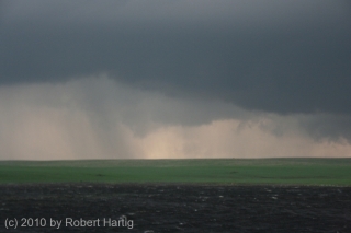
rain-wrapped tornadoes. Then it pulsed, catching its breath and gathering energy for the next round.Dropping south down CR9, we pulled aside by a roadside pond to grab a few photos. The updraft area was a couple miles to our west, and while it didn’t presently seem to be tornadic, appearance can be deceptive. The cloud base was low, nearly dragging on the ground, with suspicious lowerings forming and dissipating. It looked like it could drop something at any time, and chances are it was even then producing random, momentary spinups.
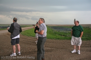
Hopping back into our vehicle, we proceeded farther south to the corner of 130th Street, where we once again parked. Here, we bumped into chasers Ben Holcomb, Adam Lucio, Danny Neal, and Scott Bennett. We had last seen these guys at a truck stop in Murdo; now here they were again, along with several other vehicles, all converging out ahead of the meso in the middle of nowhere. In the photo, left to right: Tom, Ben, Bill, and Scott.
As the storm drew closer, Tom pointed out that rotation was beginning to organize overhead. It was time to skedaddle. Back into Mike’s Outback we clambered, with Tom at the wheel, and headed east down 130th Street.
At this point, it’s important to bear in mind that every vehicle that showed up at our location had independently pre-selected 130th Street as a valid escape route. What followed did not begin as a desperate dash for safety, but as a calculated, run-of-the-mill tactical maneuver informed by commonly used mapping software. Most of the people involved were experienced chasers, some of them veterans. The reasoning behind our road choice was sound. Unfortunately, the information we based it on was not.
Thus it was was that two miles down the road, suddenly there was no road. At the front of a string of other chase vehicles, we were the first to make that
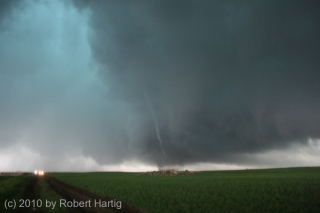
discovery. Tom turned around and started heading back, yelling to the next vehicles that the road was out. It was then that a tornado suddenly materialized in the field maybe half a mile to our west, just south of the road. It was a regular drill press, spinning furiously as it made its way toward us. It finally crossed the road and headed east-northeast a few hundred feet away, but even as it did so, another, thicker funnel snaked to the ground at roughly the same place where the first one had formed. I don’t think most people saw this second tornado; it moved toward us briefly, kicking up dirt, then dissipated, though I could still see swirling motions in the rain bands where it had been.In the photo, besides the rope tornado, notice the lowerings farther back. These meant business. We were at the eastern edge of a broad area of rotation that was dropping not suction vortices, but multiple tornadoes of various sizes, intensities, and behaviors. In my observation, these were NOT moving in cyclonic fashion around a common center, but east with the parent storm–and straight at us.
A large cone appeared to the west, which, gathering strength, moved through the field to our north. By this time, it was clear that we were in a truly lethal situation, cut off to the east by a dead-end road and to the west by tornadoes.
Windy? Hell yes it was windy. The inflow was cranking like a sumbitch, and from the looks of things, it was only going to get worse. I looked around for a ditch, but there was absolutely nothing that could have offered protection. I noticed a stout post a few yards away and contemplated lying flat and wrapping my arms around it. Tom had the same idea. Mike was eyeballing a large pile of stones a hundred yards away, thinking it might provide some shelter, but it was too far a dash with no time left to make it in.
It was at this point that UK chaser Nathan Edwards drove off the road and began heading south into the field. He told me later that he was simply attempting to clear some room for other vehicles to move forward, hopefully edging just a little bit closer to out of harm’s way, but Nate’s move prompted the rest of us to follow. In a last-ditch gamble, the entire entourage of chase vehicles began fleeing south along the fence boundary.
The tornadoes were close. Really, they were on top of us. I watched as two funnels formed a hundred yards west of our vehicle, twisting around each other and moving toward us like the “sisters” in the movie “Twister.” The rain curtain was full of swirls and braids. And what was particularly unsettling was that, as we dashed across the farmland, the business part of the storm seemed to be expanding, reaching out after us. For a mindless force of nature, this storm was displaying as close as you can get to malevolent intent.
It dawned on me that if ever there was a time to pray, and pray hard, this was it. I’m a Christian–a bit of an iconoclast in that I don’t buy into a lot of Western church culture, but I love Jesus, I’m serious about following him, and conversing with God comes naturally to me. I don’t mean just in a pinch, but as a lifestyle. You can bet that at this point, I began praying most intensely.
A couple hundred yards in, we encountered a wet area and ponding and were forced to forge our way into the cultivated field. It was there that the storm caught up with us in earnest. End of the road for real. There was nothing left to do now but hunker down, pray, and hope.
Obviously I’m here to tell the story. All of us are, every last person. That none of us were killed or seriously injured, or for that matter sustained so much as a scratch, is in my book God’s love and mercy, pure and simple. A video clip by Adam Lucio shows a tornado forming right in our midst, not ten yards from one of the vehicles. I never saw it, but Adam’s video is conclusive and sobering. We came so close, so very close. The rear flank downdraft alone had to have been in the order of 100 miles an hour. Yet nothing truly bad happened to any of us.
Some may call that a lucky draw; I call it answered prayer. Believe what you will, but there’s more to the story, an experience uniquely mine that I’ve shared with only a couple people so far. Look for it in my upcoming, final post concerning this incident. Whatever you make of it, I think you’ll agree that it’s uncanny.
That’s it for now, but this story continues. What followed with the farmer who owned the field, the sheriff and police, and other locals is for another episode, and it’s still not entirely resolved.
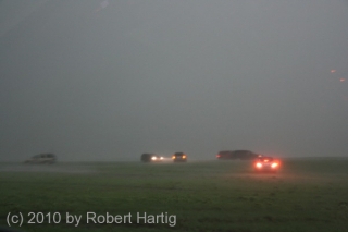
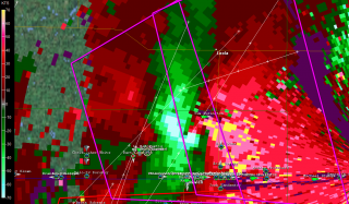
I’ll leave you with two images, both taken when the worst of the storm had just moved past us. One shows some of the vehicles getting slammed by the still-hellacious RFD. The other is a GR3 radar grab of the rotation and our location relative to it, shown by the circular GPS marker.
With that, I’ll sign off. Keep an eye out for parts four and five.
