On Wednesday night, October 17, severe storms rolled across the South, dropping a series of tornadoes across Arkansas and Mississippi, mostly in the latter state. The SPC’s storm reports show a tally of fifteen tornado reports. I’d image that the final number of actual tornadoes turned out to be smaller, as some reports no doubt were caused by the same tornado at different points along its path. A number of injuries resulted from the storms, but thankfully, no fatalities.
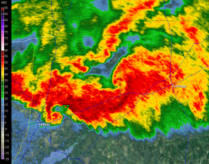
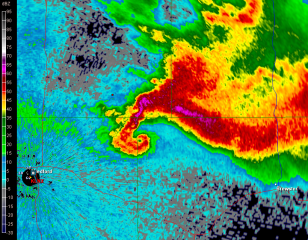
This was the last notable severe weather outbreak of the year and about the best that the late season of 2012 could squeak out.* A glance back at this date over a mugful of Fat Tire amber ale isn’t a bad way to occupy myself on this chilly November night. That evening stands out in my mind due to some crazy radar images from a tornadic storm that moved between Canton and Carthage, Mississippi. The storm appeared to be a hybrid, part supercell and part bow echo with a potent bookend vortex. It was the darndest thing.
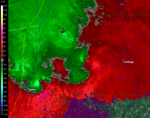
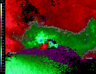
I don’t know exactly what was going on with this storm, but I certainly was surprised to see such a classic hook form out of a run-of-the-mill bow echo. In the storm-relative velocity screen, captured at the same time as the base reflectivity, you can see two pronounced couplets, one for the hook and the other for the bookend. It was fascinating to watch these features evolve.
And it got even more interesting. In a Facebook interchange over the images when they were brand-new and the storm was in progress, Matt Sellers pointed out the possibility of yet a third area of circulation at the interface between the forward-flank downdraft of the westerly located supercell and the rear-flank downdraft of the bookend mesocyclone to the northeast. If you look at the reflectivity image, you’ll see what he was talking about.
However, I don’t see anything in the storm-relative velocity grab (captured at the same time) that suggests strong rotation in that area. I just see outflow pushing south-southeastward, and not all that vigorously. Then again, I’m not skilled enough at radar interpretation that I couldn’t have missed some subtlety. What Matt said makes sense, and the somewhat detached blob of red behind the gust front seems to corroborate his thinking. The area in question could have seen some spinups that would never have been detected on radar. Interesting to think about.
_____________________
* In terms of severe thunderstorms and tornadoes. Hurricane Sandy obviously qualified as severe weather, but not as an outbreak. She was in a separate category, and one I haven’t cared to touch. Her impact was too vast, and my knowledge of hurricanes is too limited.


