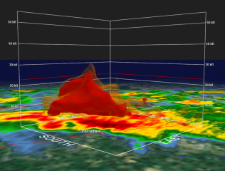
April 27, 2011, Southern Outbreak: When a Nightmare Becomes Reality

The death toll from yesterday’s tornadoes in the South presently stands at 231,* and it continues to climb. In the battered town of Tuscaloosa, Alabama, 36 people are dead; in Birmingham, at least 30 more.** From

Mississippi to as far north as upstate New York, the worst tornado outbreak in 37 years has left communities sifting through a battleground of leveled buildings, crumpled automobiles, downed power lines, tortured trees, and a horrifying number of casualties. This has been no mere tornado outbreak; it has been a tornado nightmare.

“You’re talking about whole neighborhoods of housing just completely gone,” said Birmingham Mayor William Bell in an NPR interview. “Churches, gone. Businesses, gone. I’m not talking about just roofs being blown off, but just completely gone.”**

I knew that a dangerous weather event was brewing in the South yesterday. But with my mother undergoing a knee replacement, I spent most of the day at Blodgett Hospital here in Grand Rapids, Michigan. I knew nothing of what was transpiring down in Mississippi, Tennessee, and the epicenter of the outbreak, Alabama, until later in the evening, when I finally left the hospital, fired up my laptop, and got my first look at the radar.

There it was, spread out before me: a blitzkrieg of intense supercells swarming across Alabama and Tennesse, attended by so many tornado reports that they obscured parts of the map. My heart dropped into my gut. I didn’t need any news reports to tell me that something awful was happening and people were getting killed.

Immediately I thought of my long-time friend and storm chasing partner, Bill Oosterbaan. He was down there somewhere in Alabama. I had no question that he’d seen tornadoes, but was he safe? I couldn’t reach him at first on his cell phone, but eventually we connected and Bill shared his story. He had been about a quarter-mile behind a tornado that hit Huntsville and gotten rained on by debris. It sounded bad, but Bill was okay, had witnessed five tornadoes, and had gotten video footage.

After talking with Bill, I began searching for news on Facebook and the Internet. The first video I saw was Chris England’s footage of the Tuscaloosa tornado as it chewed through the city. “Andover!” I thought. “It looks like the Andover tornado.” (An F5 monster that struck Andover, Kansas, on April 26, 1991.) More YouTube videos followed: Mind-boggling views of the Tuscaloosa storm. TWC footage of a violent, mile-wide wedge moving through Birmingham. An intense tornado striking Cullman. It was horrible. The storms were ongoing even as I watched, and it dawned on me that, overworked as the word “epic” has become, here was a situation where it applied.

I am appalled by the news and deeply saddened. As good as today’s weather warning system is, nevertheless the death toll is mind-numbing. I frankly expected a few score fatalities, and that in itself would have been too many. Lives are lives. But this many lives…it is just sickening. Were it not for the unswerving vigilance of the Storm Prediction Center and the National Weather Service; and were it not for today’s NEXRAD system that blankets the nation with Doppler radar to provide coverage that far outstrips what existed during the historic 1974 Super Outbreak and 1965 Palm Sunday Outbreak; were it not for these things, then the death toll from yesterday would have been apocalyptic. As it stands, it is horrifying, and the number continues to grow.

My writing on this event is finished for now. There is simply too much to say and too much news that is yet breaking, along with countless hearts. The story has just begun, and more can be told only as it becomes known. My thoughts and prayers go out, with those of countless other storm chasers, to the survivors of this terrible disaster.

————————————

* From CNN’s live blog.

** From NPR’s news blog, “The Two-Way.”
Yazoo City Tornado Number Two: A Stormy Night in Mississippi

Last night’s tornado in Yazoo City, Mississippi, thankfully appears to have been not nearly as bad as its monstrous EF-4 predecessor back in April, but it was bad enough. It was one in a round of tornadoes that trampled across the South yesterday afternoon on into the night. Fed by ample moisture and energized by bulk shear exceeding 60 kts and 1km helicity exceeding 300, supercells had no problem firing up and dropping tornadoes. At the time of this post, seven tornado reports have been logged for Dixie Alley–one in Louisiana and six in Mississippi. (A tornado was also reported in northwest Missouri, but that’s far removed from the southern storms and was a separate situation.)

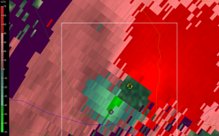
I watched my GR2AE radar screen in disbelief last night, shortly before 9 p.m. EST, as strong circulation progressed from the southwest toward Yazoo City. “No way,” I thought. “No freeking way.” How could the same small town get clobbered by a tornado twice in the same year? It wasn’t going to happen. It just couldn’t. But it did.

At 8:18 CST a tornado warning was issued–a continuation of a previous warning–which contained the following statement: AT 816 PM CST…LOCAL LAW ENFORCEMENT REPORTED DAMAGE FROM A TORNADO JUST PASSING THROUGH THE CITY. THIS TORNADO WAS LOCATED 6 MILES SOUTH OF EDEN MOVING NORTHEAST AT 50 MPH. At that point I could see the potent SRV couplet moving right through what appeared to be the south edge of the town. According to reports this tornado crossed the path of the April storm, like a letter X. Fortunately, it appears to have been nowhere nearly as large or violent, and a scan or two later showed the mesocyclone weakening considerably as it left the city. Here is the string of reports from the National Weather Service at Jackson:

0800 PM     TORNADO          5 SW YAZOO CITY         32.81N 90.47W
11/29/2010                   YAZOO              MS   AMATEUR RADIO

            3-4 MILE LONG PATH OF DAMAGE ALONG EAGLE BEND ROAD.
            LIKELY TORNADO DAMAGE. UPDATED...VEHICLE
            OVERTURNED...STRUCTURAL DAMAGE...SHOP DESTROYED. NEAR THE
            NORTHERN INTERSECTION OF EAGLE BEND ROAD AND HWY 3.

0808 PM     TORNADO          YAZOO CITY              32.86N 90.41W
11/29/2010                   YAZOO              MS   AMATEUR RADIO

            DAMAGE TO THE COURTHOUSE ROOF IN DOWNTOWN AND A LARGE
            TREE DOWN NEXT TO THE COURTHOUSE. WIDESPREAD DEBRIS IN
            THE AREA.

0810 PM     TORNADO          YAZOO CITY              32.86N 90.41W
11/29/2010                   YAZOO              MS   AMATEUR RADIO

            ADDITIONAL STRUCURAL DAMAGE REPORTED IN YAZOO CITY WITH
            NUMEROUS LARGE OAK TREES SNAPPED AND UPROOTED. POWER
            LINES ALSO REPORTED DOWN ALONG CENTER RIDGE ROAD.

0810 PM     TORNADO          YAZOO CITY              32.86N 90.41W
11/29/2010                   YAZOO              MS   EMERGENCY MNGR

            MAJOR STRUCTURAL DAMAGE REPORTED TO AT LEAST 18
            BUSINESSES...MINOR DAMAGE TO AT LEAST 3 WOODEN FRAME
            HOUSES. ENTIRE FACADE OF ONE DOWTWON BUILDING HAD ALL
            WINDOWS BLOWN OUT. 30 PERCENT OF YAZOO CITY REMAINS
            WITHOUT POWER.

0810 PM     TORNADO          YAZOO CITY              32.86N 90.41W
11/29/2010                   YAZOO              MS   AMATEUR RADIO

            POWER LINES...TREES...AND WIDESPREAD POWER OUTAGES ARE
            REPORTED WITHIN YAZOO CITY. WILL UPDATE FURTHER WITH
            ADDITIONAL INFORMATION.
.

While Yazoo City stands out by virtue of having gotten hit twice this year, other communities also sustained damage. The show began in the afternoon and evidently continued through the night, because when I woke up this morning and fired up my computer, I saw a tornado warning in Alabama. Tornado watches are currently in effect for the southeast, and the SPC shows a slight risk extending north as far as southeastern Pennsylvania, with a 10 percent hatched area reaching from South Carolina into Virginia.

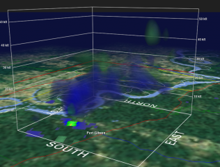
The images on this page are GR2AE volume scans of the next supercell southwest of the Yazoo City storm, heading on a trajectory just west and north of Port Gibson. Click on the images to enlarge them. The time was 0232Z, or just a couple minutes after 8:30 CST. The topmost frame shows a hook and correlated structure above it, with the suggestion of a pretty healthy BWER. The bottom frame depicts vigorous rotation.

New High-Resolution Level 3 Radar Coming in February

Last night Grand Rapids got its first snowfall, and this morning I switched the color tables on GR3 and GR2 to winter mode.

Ugh. I suppose that blue, pink, and purple are going to rule for the next four months. I much prefer plenty of yellow, orange, and red, at least when it comes to radar displays, but we’re at that time of year when those colors aren’t likely to be very meaningful, El Nino or no El Nino.

While switching color tables is relevant to me as a Michigan resident who’s bracing for the winter, it’s nothing compared to the changes coming down the pike for GR3 and other level 3 data users in February. Here’s a message that Gilbert Sebenste of Allisonhouse, a well-known private supplier of raw radar data, posted in the AH and Stormtrack forums:

We have just been informed by the National Weather Service that starting in February 2010, and lasting through April, 2010…the National Weather Service will add higher resolution Level3 radar data products, replacing quite a few of the ones you use right now. The legacy products will continue to be sent for 6 months after all of the replacement products have been added, and will be discontinued on December 1, 2010.

What it all means in a nutshell is this:

1. Resolution will increase
2. The number of reflectivity levels will increase to 256 (meaning you will need to have 256 colors in your color palette to display all the intensity levels)
3. The volume of the files will double, on average
4. The Level3 format will change
5. It will be completed by the end of March, 2010…with legacy products ending 12/1/2010.

Allisonhouse will be working closely with its software partners to provide a seamless as possible transition to the newer and better products upon receipt of transmission from the National Weather Service, and we will provide you with more information as it becomes available.

Wow. Now those, folks, are changes, and it looks like they’ll be here right in time for storm season 2010. High-res level 3–imagine that! My one issue with level 3 has been its coarseness, but that problem is about to be solved. Within a few short months, level 3 data will be coming to us with the same finely shaded resolution as high-res level 2 while remaining a usable product in the field, which is what GR3 is designed for.

Of course, no chaser is going to love the idea of doubling the file sizes. But the improvements look to be awesome, and will give us much more detailed images of storms.

Other Changes on the Way

.

Exciting as the rapidly approaching implementation of high-res level 3 data is, it’s not the only significant development on the horizon. Next year will also see a major phasing-in of dual-pole radar to WSR-88D stations throughout the country. And in the private sector, Andrew Revering of Convective Development, Inc., is working on a huge upgrade for F5 Data forecasting software.

In summary, the technical/informational side of storm chasing will be seeing some significant advancements in the coming year. However many of those improvements are ready for next spring’s severe weather season, let’s just hope that the storms themselves put in a decent appearance.