It has finally arrived: Winter. Astronomical winter, that is. Meteorological winter has already been with us for three weeks, beginning December 1, and in my book, that is the more climatologically accurate date. Particularly this year. For the first time since 2009, we in Michigan have been experiencing a good, old-fashioned Great Lakes winter. Here in Caledonia, the snowfall has exceeded a foot, and Lisa, who arrived here from Missouri five years ago hating winter and now loves it, dotes on it, rejoices in it, has been having a high good time during her two daily walks, equipped with brand-new winter hiking boots and a warm, warm, waaarm and dry, dry, dry waterproof down coat.
I am not so enthusiastic about all this white stuff as Lis is. My interaction with winter consists largely of sitting indoors at my work station, gazing out through the sliding door, watching the finches argue at the feeders and the woodpeckers whack away at the suet, and watching snowflakes pirouette gracefully out of the sky, and thinking, “Can we get this over with?”
Yes we can, in a few more months. Because today at last we tip the scale, and from here on, daylight will be on the upswing.
Two weeks ago, on December 8, the sun set in my town at 5:08 p.m. EST, just as it had been doing for the preceding four days, hovering within the eight-minutes-past-the-hour range but setting just a few seconds earlier each day. The 8th was the earliest sunset date of the year. From then on, sunset time would arrive incrementally later. For the next five days, through December 13, it would remain at 5:08, but instead of losing seconds, now it would begin to add them back until, on December 9, the sun would set at 5:09.
The converse does not, however, hold true for the day’s first light. The sun will continue to rise later and later until January 3 of the new year. By then, the sun will have been rising at 8:14 a.m. for five days until finally, on that date, the sunrise will, like the sunset, hit its own tipping point. From thenceforth, losing a few seconds each day, it will begin its slow march toward an earlier and earlier hour. On January 8, it will rise at 8:13 a.m.; on January 12, at 8:12; on the 14th, at 8:11; and so it will go, until on the 31st, it will rise at 7:59. By then, the sun will be rising approximately a minute earlier each day, and we will have gained fifteen minutes of sunrise time.
Why, then, is today, winter solstice, so special? Because today marks our shortest period of overall daylight, the narrowest space between sunrise and sunset. From tomorrow on, even though the sun will continue to rise later and later for a while, the sunset time will begin to outpace it and the gap between sunrise and sunset will broaden–slowly at first, then with increasing swiftness. By the end of December, we Grand Rapidians will have gained 41 seconds of daylight for a total of 9 hours, 14 minutes, and 16 seconds on December 31. By March 18, we’ll be adding daylight at 2 minutes and 15 second per day, at which point we’ll have maxed out and the gains, while still continuing up to the summer solstice, will become gradually less.
You now know more about the winter solstice than you probably ever cared to. What makes this particular solstice even more interesting is the weather that’s shaping up for it, which shows promise of making it a headliner with tornadoes in the deep South and ice storms to the north and west.
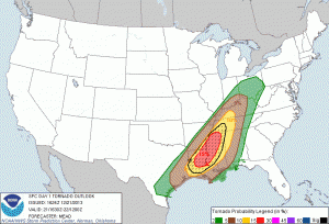
 Here is the 1630Z convective outlook for today, depicting a moderate risk stretching from western Kentucky and Tennessee southwestward into Louisiana, with a 15 percent hatched area for tornadoes.
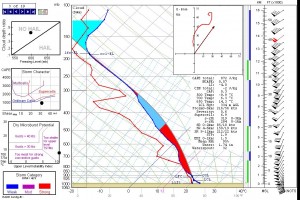
Given the brevity of daylight, I find this situation interesting but not particularly appealing. A look at forecast soundings suggests a crapload of rain, low CAPE, and high helicity, all driven by massive shear and  rocketing along through formidable terrain. A lot of chasers are out there, and I’m sure that if I lived in that area, I’d be among them, but looking at the Shreveport radar, I don’t feel like I’m missing out on something. I got my fill of chasing fast-moving, rain-wrapped storms last November in optimal territory, and considering how that chase turned out, I think I’ll be a lot more selective about such scenarios in the future. That said, I wish those who are out there good success.
And safety. Drive carefully, mates and matesses. No storm is worth jeopardizing your safety over.
As for me, I’m sitting well on the other side of the cold front, and freezing rain is in the forecast, though my local WFO has backed off on it in their forecast discussion. Lots of areas in the Midwest are getting hit with icy conditions, making for hazardous driving, power outages, downed tree limbs, and the like.
The day grows later, and so far, glancing at the radar down south, I just don’t see anything very exciting–just a messy-looking MCS with one cell south of Memphis showing a hint of rotation. Only wind reports so far, and I suspect that’s how this thing will continue to play out. Tough for anyone who drove down there hoping for more; good for denizens of the region.
And so enters the winter of 2013–14. Time to wrap up this post and get on with the rest of this afternoon.

