Saturday, September 22, was the first day of autumn 2012. It was also my first-ever time seeing waterspouts. I’ve chased them a few times (if chased is the right word) previously within the past two years, but not successfully. This time made up in spades for those occasions. I don’t know how many waterspouts I saw, but “lots” ought to cover them, including one that made landfall about a hundred yards north of me at Tunnel Park. I managed to capture that one on video. But I’m getting ahead of myself.
I woke up at 5:15 a.m., showered up, and headed for the lakeshore. The ICWR waterspout forecast indicated a high probability of waterspouts all along the eastern shore of Lake Michigan, and the main concern seemed to be simply finding adequate near-shore convection. That didn’t seem to be a problem, since a line of thunderstorms was moving across the lake from Wisconsin and heading east almost straight at me. Based on the line’s slightly southern component, I decided to head for Holland Beach.
A nice cumulus field had overspread West Michigan as I pulled into the state park. At the entrance, a ranger informed me of restricted parking due to a marathon that was being routed through the park by the beach. The racers hadn’t yet arrived; in fact, very few people were present, and having the parking lot mostly to myself, I chose an optimal spot where I had an unimpeded view of Lake Michigan.
The stiff lake breeze concerned me. Westerly surface winds–and strong ones at that–didn’t seem to me to bode well for waterspouts. How would the convergence necessary for spout formation occur over the water with unidirectional winds? Still, the waterspout index was maxed out, and here I was, so I guessed I would find out.
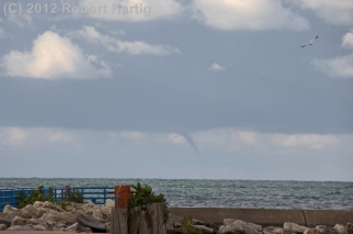
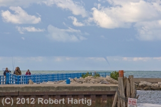
After a while, the western sky began to darken. The storms were moving in, but they would take a while to arrive. Meanwhile, a green blob of convection on GR3 corresponded with a cloud bank stretching perpendicularly from the waters to the shore about ten miles to my south. It seemed worth checking out, so I grabbed my camera and headed across the beach toward the pier near the lighthouse. From that vantage point, I finally got a good, complete view of the convective band.
A slim, well-defined gray tube hung from the distant cloud base. Bingo! My first waterspout! I began snapping pictures.
The salmon run was on, and all along the channel, fishermen were having a heyday. Focused on fish, they seemed oblivious to the elegant spectacle unfolding over the water. How could they not see it? I pointed it out to one fisherman. “Wow! A waterspout!” he said. Then he went back to his fishing. To each his own, though I suppose he could fish and watch the spout at the same time.
I don’t know how much time passed–fifteen minutes, maybe twenty. By and by, the spout dissipated, and I returned to my car. I didn’t need to look at my radar to know that the storm was closing in. I could see the lowering clouds and rain shafts over the water.
What the radar did tell me, however, was that heavier convection was heading toward the Saugatuck/South Haven area. So, as the first of the marathoners began to trickle into the park, I decided to drop south toward where chasers Skip Talbot, Jennifer Ubyl, and Jonathan Williamston were located.
I got as far as US 31 before realizing that I had made a tactical error. Heavier convection was beginning to fire in a line that promised to train in directly over Holland Beach. Nuts. I had just compromised myself by fifteen minutes, and in the meantime, a marathon had gotten underway. I turned around and headed back toward my old location, but now the road was filled with runners and closed to traffic.
I decided to head for Tunnel Park just a few mile north of Holland Beach. But Lakeshore Drive was also clogged with marathoners. Thus began a frustrating quarter-hour of driving down sideroads and through neighborhoods, trying to gain access to the lakeshore. Ultimately, I wound up pulling over kitty-corner across the road from the park entrance, watching morosely as runners ran by. But there was a cop standing next to his car, shepherding the crowd, and … what the heck. I walked up to him and asked him if I could cross into the park. Sure, he said. The race ended officially right at this point. Just look for an opening, the cop told me, and then I could nudge my car across the road.
Free!
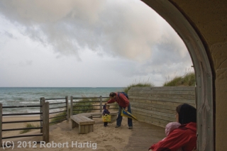
The storm was arriving as I pulled into the park, and rain had begun to fall. I grabbed my cameras and raced toward the tunnel. The other end opened out onto the beach, affording a sheltered location where I could watch for spouts without getting wet. It was a perfect setup.
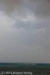
The only other people there at the park were a young ethnic couple with a baby and a small child. I greeted them and talked with them about waterspouts as we watched a shelf cloud advance over the storm-driven surf. After a few minutes, the guy pointed toward the lake and said, “Is that one?” I looked, figuring it was a false alarm, some turbulent scrap of scud ascending along the shelf cloud. But no, he was pointing at the water, where a rotating patch of spray was clearly visible. It was only a couple hundred yards away, small but unmistakable. Waterspout!
And now another, larger one was organizing to my northwest. I could see no funnel, but then, the shelf cloud was now almost directly overhead, and features that might have been obvious at a distance were lost in the jumble of clouds. Regardless, the rotating cascade looked intense. I grabbed my camcorder. There was no time to set up the tripod; I would have to manage the best I could with hand-held. I hit “record” and began shooting the waterspout as it progressed toward the shoreline.
At first, it appeared to be heading toward us, which didn’t concern me. The waterspout was non-tornadic, and while it obviously packed some strong winds, I felt that the greatest threat it posed was a nasty sand-blasting. We could retreat into the tunnel if necessary.
But the spout made landfall about one hundred yards to my north. I ran out onto the beach to try to capture more of it as it progressed up over the foredune, but I was too late, and that section of my footage turned out pretty wobbly. Still, I had about forty-five seconds of shaky but ultra-cool footage of a Lake Michigan waterspout hitting the shore at close range. The first thirty seconds is the best, but I’ve chosen to show the whole shebang because I think there are some points of interest in the latter part, flawed though it is.
Back at my car, the radar indicated more intense convection headed toward Grand Haven. After sending a report to Spotter Network, I got onto Lakeshore Drive and began heading north. The stream of runners had thinned out, and the road was open, though still patrolled by the police. A little ways north of the park entrance, I noticed a “damage path” of tree trash–clusters of leaves and large twigs–scattered across the pavement. The road was only a quarter-mile from the shore, and I have no idea how far inland the waterspout made it before dissipating, but I suspected that a few runners had gotten quite a surprise.
Up at Grand Haven, a cloud bank to my northwest put down a series of spouts. These were much farther offshore and not particularly impressive at the time I viewed them, though I’ve seen some stunning photos by another spout chaser from the same location. After a while, the waterspout activity dwindled off, but I’d gotten my fill and was glad to head back east.
Back in Grand Rapids, I processed my video of the spout at Tunnel Park and attempted to send it to WOOD TV8. But the ftp upload failed, so rather than waste more time, I stopped by the station and let their tech handle things. The footage got aired on the evening news.
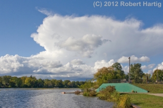
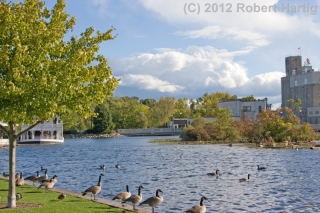
After that, I somehow wound up in Lowell. It was a lovely, moody day, perfect for the first day of fall, and I guess I just felt like a drive. Anyway, I found myself on the waterfront, watching ragged cumulus clouds drift over the broad, windblown face of the Flat River. To the north, a small, low-top storm billowed up above its less successful convective comrades and spread its cirrus anvil eastward. It was a beautiful sight, as was the entire sky, and I couldn’t resist taking a few more pictures. The last view on this page looks to the south, where the Lowell Showboat rests at its dock just upstream from the Flat River Grill and the dam beneath the startlingly blue September sky.
And that is that. Two days later, the same intensely azure sky prevails and this chill wind testifies that autumn is indeed at hand. The trees are still mostly green, but change is in the air. My hunch is, we won’t be getting a “second season” for storm chasing. If not, Saturday was wonderful compensation and will see me through to next spring.
