September 3, 2011, Outflow Boundaries

Yesterday morning my friend Kurt Hulst called to say, “Grab your camera. There’s a great shelf cloud coming your way. It passed my location before I could get a picture.”

Okay, then. My apartment faces east, and all I could see was blue sky. Not even a hint that a storm might be approaching from the west, and usually one gets at least some kind of a clue. But I snatched up my camera and car keys regardless and headed outside.

Yes, there it was–a hazy arcus cloud moving my way from the west and northwest. I hopped in my car, with the intention of finding a better view for taking photographs than my parking lot afforded. But the cloud was moving faster than I realized, and by the time I reached 108th Street, it was almost on top of me. So, with the wind kicking up flurries of leaves in front of me, I headed east, thinking to put a little distance between the shelf cloud and me.

Several miles down the road, I turned north, parked by a buffalo farm, stepped out of my car to get a look, and realized immediately that my cause was lost. The cloud was right overhead. It had to have been moving at least 60 mph. So much for weather photos. Within seconds, I was looking at the backside of the arcus, and it wasn’t particularly photogenic.

For that matter, there wasn’t much to it. No ensuing rain, no lightning, no thunder, no storm at all, just blue skies. I can’t speak for other parts of the country, but here in Michigan it is an odd thing to observe an impressive-looking shelf cloud with absolutely nothing behind it! The cloud evidently had formed as the isolated effect of cold outflow from dissipated storms back in Wisconsin, in conjunction with a closer, severe-warned MCS to the north. Back at home, I could see the outflow boundary arching southwest all the way down into Indiana and moving rapidly east.

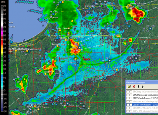
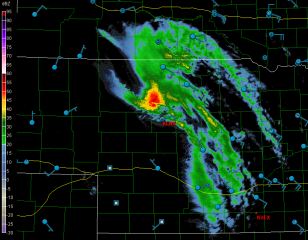
Yesterday seemed to be the day for such phenomenon to be clearly defined on the radar. Later in the afternoon, GR3 showed a similarly highly distinct outflow boundary down in northern Indiana. The source of this one was easy

to see: storms to its northwest and north. It looked pretty vigorous, and I wondered if it was putting on a show similar to what I had witnessed.

As an item of curiosity and an example of a highly defined outflow boundary–I suppose you could call it a runaway gust front–I captured a screen shot. Click on the image to enlarge it.
An Independence Day Double-Header: Summer Weather Is Here

It’s July 4, Independence Day. Happy Birthday, America! For all the problems that face you, you’re still the best in so many, many ways. One of those ways, which may seem trite to anyone but a storm chaser, is your spring weather, which draws chasers like a powerful lodestone not only from the all over the country, but also from the four corners of the world.

no images were found

This has been an incredible spring stormwise, but its zenith appears to have finally passed for everywhere but the northern plains. And right now, even those don’t look particularly promising. That’s okay. I think that even the most hardcore chasers have gotten their fill this year and are pleased to set aside their laptops and break out their barbecue grills.

Now is the time for Great Lakes chasers to set their sights on the kind of weather our region specializes in, which is to say, pop-up thunderstorms and

no images were found

squall lines. The former are pretty and entertaining. The latter can be particularly dramatic when viewed from the eastern shore of Lake Michigan, sweeping in across the water like immense, dark frowns on the edge of a cold front. If you enjoy lightning photography, the lakeshore is a splendid place to get dramatic and unobstructed shots. Not that I can speak with great authority, since so far my own lightning pictures haven’t been all that spectacular. But that’s the fault of the photographer, not the storms.

The images on this page are from previous years. So far this year I’ve been occupied mainly with supercells and tornadoes, but I’m ready to make the shift to more garden variety storms, which may not pack the same adrenaline punch but lack for nothing in beauty and drama.

July 4th is a date that cold fronts seem to write into their planners. I’ve seen a good number of fireworks displays in West Michigan get trounced by a glowering arcus cloud moving in over the festivities. But tonight looks promising for Independence Day events. Storms are on the way, but they should hold off till well after the party’s over.  That means we’ll get two shows–the traditional pyrotechnics with all the boom, pop, and glittering, multicolored flowers filling the sky; and later, an electrical extravaganza, courtesy of a weak cold front. A Fourth of July double-header: what could be finer than that?