April 13-14 Oklahoma-Kansas Chase

This post is long overdue, but there has been no helping the time lapse between my first Great Plains chase of the year on April 13-14 and tonight, when I’m finally setting the highlights of those days briefly in print. The reason is that, upon my return home, I immediately succumbed to the worst case of acute bronchitis I’ve ever experienced. It was characterized by constant, deep, wrenching, non-productive coughing; a chronic sore throat; a fever that topped 102 degrees; an ear infection; laryngitis; plugged-up sinuses; and if I’ve missed anything else, let me just sum it all up by saying that I was in neither the condition nor the mood to do any film editing or writing, or much of anything except to attach my face to a vaporizer and to suck down Jell-O, chicken soup, sports drinks, ginger tea, and enough fluids overall to qualify me as a human aquarium.

Today, though, I am definitely on the mend, and it’s high time I got this report written. Tomorrow looks to be another big day in eastern Kansas, so I need to write before anything I have to say about an event from two weeks ago gets swallowed up in the latest round of wedges.

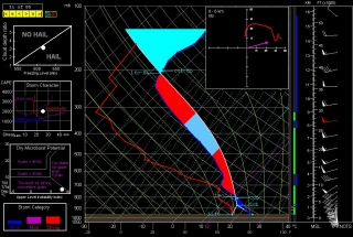
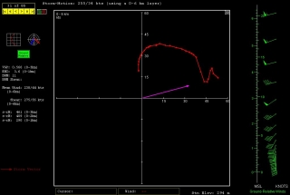
And it does look there could be some wedges. Look at this NAM skew-T and hodograph for Chanute, Kansas, at 00Z. (Thanks, Ben Holcomb, for tipping me off to Chanute!) With 1km and 3km SRH at 290 and 461 m2/s2 respectively and a nice, fat low-level CAPE, that’s the broth for some violent

tornadoes. I expect that part of the area that the SPC has categorized as a light risk for tomorrow will be upgraded.

But I’m chasing rabbits. Getting back to the topic of this post: With conditions coming together for two or three days of severe weather in tornado alley from April 13-15, Bill Oosterbaan and I headed for Oklahoma in company with two new chaser friends. Rob Forry is a fellow chaser from the other side of Michigan who had yet to experience a Great Plains chase; and Steve Barclift is an editor friend of mine who, I discovered, shares my keen interest in severe weather and had been wanting to get a feel for storm chasing.

We arrived in Norman, Oklahoma, late in the morning on Friday the 13th. Dropping off our travel bags at the apartment of Ben Holcomb, who was graciously putting us up for the night later on, we promptly headed out for the chase.

We encountered our first storm of the day not far from Chickasha. Not being the superstitious type, I have no qualms about chasing storms on Friday the 13th; still, this storm gave us a shake when it led us back to Norman and spun a tornado within a mile of Ben’s apartment. We pulled out of chase mode long enough to make sure that Ben’s place was okay. Then we headed southwest a second time, this time plunging beyond Chickasha toward Boone and Meers, and thence into the heart of the Wichita Mountains. There, we positioned ourselves on the southeast flank of a tornadic supercell as it advanced slowly over the ragged landscape.

We may have witnessed a tornado at this point, but my video provides no conclusive evidence, just strong suggestions. Tornado or not, though, to stand in the inflow of that massive, beautifully crafted supercell and watch it spew lightning from its charcoal interior as it dragged across those prehistoric peaks was reward enough. No more need be said, nor shall be, since Friday was simply a scenic prelude to the action up in Kansas the following day.

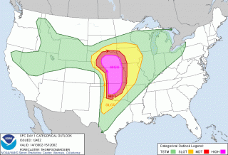
Saturday, April 14, dawned on a large high-risk region that ranged from most of central and eastern Nebraska south through central Kansas and down into much of central Oklahoma. With impressive upper- and mid-level jets overlaying the region, bulk shear was beyond adequate, as was instability. The ingredients were all there. Today, it seemed, would be one of those days when anyone who chased–and there were lots of chasers prowling the prairies on this day–would see a tornado.

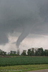
In practice, though, it wasn’t quite that easy. Our plan was to drift up I-35 and then head west toward a likely looking storm. Not a very sophisticated approach, but it seemed likely to work, and in fact it did. We weren’t far across the Kansas border when we decided to turn west, and in a while we encountered our first supercell of the day, and with it, our first tornado. The cone spun at a good distance, probably five miles or more away. Looking at my video clip, I’m satisfied that it was indeed a tornado–even at that distance, the outline is distinct and separate from the storm’s rain shaft.

We stuck with our storm as it sailed north-northeastward, but it seemed to be having a hard time establishing itself beyond its first tornadic salvo. Still we stayed with it, hoping it would organize into a rumbling monster. But it continued to attenuate into a skinny, sorry-looking mongrel, so we finally dropped it for a more promising-looking storm to its south.

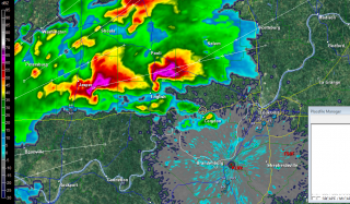
I remember saying at the time, “Dropping this storm [which I was in favor of doing] could be a really good decision. Then again, the storm could reorganize in half an hour and start putting down hoses.” Of course, the latter is what happened. Half an hour or forty-five minutes later, the storm we had put behind us had morphed into a supercell that, from the looks of it on radar, clearly wasn’t fooling around, and it went on to produce a string of tornadoes.

But by then we were committed to the storm to its south, a deceptively imposing-looking beast that washed out on us as we tangled with it and ultimately disappeared completely from the radar screen. Long before that happened, we wisely abandoned it for the next storm down the line, and as the saying goes, the third time was a charm. Just drawing closer to the storm environment, we could tell that this storm was of a different caliber. There was more lightning. The inflow was strong. The thing just felt tornadic. And it was.

From here on, I’ll let my video clip tell the story. It chronicles our chase from near Pretty Prairie, where we encountered our first tornado with this storm at close range with rain bands wrapping toward us, on north-northeastward toward Lost Springs and Delavan. The latter, night-time portion of the video is best viewed in dim light.

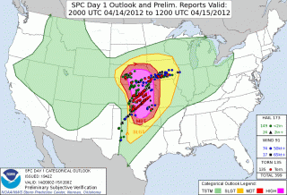
On a side note, the SPC did a great job of forecasting this widespread outbreak, as you can see from this verification of the outlooked areas with confirmed tornadoes. One thing that puzzles me is why they showed a 45 percent hatched area for Nebraska, when from what I recall, the NAM and RUC didn’t appear at all bullish for a northern play. At the time, I figured that those SPC guys must have known something that the models weren’t revealing, but in fact the majority of tornadoes occurred southward in Kansas. If anyone from the SPC happens to read this, I’d welcome your comments on the thinking behind the enhanced focus on Nebraska over regions southward.

We overnighted east of Kansas City, and the following day found us chasing a warm-front scenario in south central Minnesota. The setup this day was utterly unlike the previous day. In fact, with the surface low nearly collocated with a closed 500 mb low to our west, we were dealing with what seemed like a quasi-cold-core setup. The storms, low-topped supercells, formed in convective “streets” that moved nearly straight northward, each street progressively kicking off new convection to its east where outflow presumably converged with strong southeasterly surface winds. Tornado reports occurred to the north, along or just past the warm front, where winds backed strongly.

The setup was an interesting one particularly in that tornadoes were reported on the cold side of the front, which cooled markedly within a matter of a few miles. This seemed counterintuitive: what kind of surface instability was available in such an environment? I recalled my chase with Kurt Hulst and Dave Diehl back in February, 2006, when we watched a storm on the far eastern side of a cold core drop a tornado several miles to our south. Where we stood, the air was so cold that I could see my breath; yet across the distant treeline, an unmistakable tornado was spinning and doing damage in a small town east of Kansas City.

As for this present date, while the four of us didn’t see a tornado on April 15, we did see the most wildly circulating wall cloud I’ve ever laid eyes on. The motion in the thing was unreal, something I attribute to the storm’s crossing the warm front and encountering a radical backing of winds.

Inevitably, we found ourselves in Minneapolis, at which point we left chase mode and headed for home. The first few coughs that would rapidly blossom into the debilitating bronchitis I mentioned at the start of this post were just getting hold of me. The following day would mark the beginning of a miserable two weeks. I’m just glad the virus held off till I got home.

Now I’m almost recovered–not in enough time for what looks to be a lively day in Kansas tomorrow, but certainly for the next round after.

For another perspective and some absolutely stunning videos of the Kansas outbreak of April 14, visit my friend Kurt Hulst’s blogsite, Midwest Chasers.
Heading Home from Kansas

Bill Oosterbaan, Steve Barclift, Rob Forry, and I have had a fun time chasing low-top supercells today in Minnesota on our way home from two action-packed days in Oklahoma and Kansas. Now, at the end of day three, we’re heading east on I-94, with Minneapolis fresh behind our backs and seven hours of driving ahead of us.

The four of us witnessed several tornadoes–how many, it’s hard to say for sure, but we’ve agreed upon six–during yesterday’s massive outbreak. We tangled unsuccessfully with two supercells before hitting paydirt with a storm that dropped a string of swirlies around Hesston, Goessels, and points beyond. And yes, I shot some decent video, which I’ll post on YouTube once I’ve edited it, and also subsequently embed in a post here on Stormhorn.com. Consider this little placeholder to be a friendly heads-up that more is on the way in a day or two. Till then, ciao.

First Plains Chase of 2012 Coming Up

I headed this afternoon to my tax man’s office with a sense of dread and walked out with glee in my heart and a refund coming to me from the IRS. Sweet! Just what I need to help finance my storm chases this year. I am due for some good ones. Last year I was miserably sidelined while my friends pounded the highways during a spectacular, albeit tragic, tornado season. This year, God willing, I’ll witness some beautiful tubes and breathtaking structure drifting across the vast sublimity of the Great Plains. March 2 was a mind-blowing start. Now I hope to capture my next round of video in a few days.

I won’t bother with talking about forecast models and such right now, though you can bet I’ve been keeping my eyes on the GFS and the Euro, and now the NAM. The big thing is, instability, moisture, and shear all seem to be lining up nicely. So Thursday evening I’ll be heading for the convective manna-land of the West with my buddy, Bill Oosterbaan. Joining us will be a friend of his from across the state as well as Steve Barclift, an editor from Kregel Books who shares my love of storms and has been wanting to chase a few of them with me. Hopefully this weekend will provide both of these guys with a great introduction to the science, the art, the craft, and the awe of storm chasing.

I am so looking forward to chasing storms once again out on the prairie! At last! There is no other place on earth like the Great Plains!

‘Nuff said for now. Right now the other half of me–the jazz musician half–is calling out to me and demanding some time practicing my sax. Who am I to say no. I’m off.

An Interview with Tim Vasquez, Owner of Stormtrack: A Mesoscale Forecasting Expert Shares Reflections on the Past and Glimpses into the Future

Among the various weather-related forums extant today, Stormtrack has one of the longer—perhaps even the longest—track records. Not only so, but it also carries on a rich legacy begun in 1977 when pioneer storm chaser David Hoadley published the first Storm Track newsletter. The newsletter evolved into a magazine, the publishing torch passed on to veteran chaser Tim Marshall, and the print edition ultimately morphed into an online forum for chasers worldwide under the ownership of Tim Vasquez.

Like Stormtrack, Tim has a rich and varied background replete with experiences that range across the weather spectrum, from storm chasing to operational forecasting to education and more. From 1989 to 1998, Tim served as an Air Force meteorologist. As early as 1985, he developed weather analysis software tools, which eventually culminated in WeatherGraphix and Digital Atmosphere. He has also published a series of weather forecasting books, including Severe Storm Forecasting and the Weather Analysis and Forecasting Handbook. Tim’s resources and services—which include nowcasting and forecasting training for storm chasers—are available through his WeatherGraphics website.

Tim is obviously one very busy guy, not to mention one of the most recognized names in storm chasing circles. In this interview, he shares some fascinating, personal perspectives on storm chasing and mesoscale forecasting back in the day as well as today. Amid the cornucopia of forecasting tools and resources that are now available to chasers, it’s eye-opening to learn not only what existed over two decades ago, but also how determined and knowledgeable a person had to be in order to tap into it. And it’s exciting to consider some of the possibilities that the future has in store.

Enough of this introduction. I hope you’ll enjoy what follows.

Interview with Tim Vasquez

.
Question: Owner of Stormtrack.org, the renowned, longstanding forum for storm chasers worldwide. Forecasting software developer, meteorological consultant, severe weather educator, author of a series of outstanding books on storm chasing and forecasting, professional nowcaster … you’ve covered pretty much every base there is, Tim, except for storm chasing tour guide. I don’t think anyone who’s been seriously involved in chasing for even a brief amount of time doesn’t recognize you as one of the gurus of operational forecasting.

In the midst of all that, one of the sides of you with which I think people are least familiar these days is who you are as a storm chaser. Yet unquestionably you’re an extremely seasoned chaser, one of the true veterans. So let’s talk about that part of you, beginning with how it all started. What first got you enamored with severe weather and tornadoes? Was there a defining moment, or moments, back in your formative years?

Tim: I would say the defining moment came in May 1985 when I was at the National Weather Service in Fort Worth. There were never any good forecasting books at the libraries and no Internet, and AMS publications were expensive. The NWS office there had a little reading room, so I used to go over there to sift through their technical library and page through their saved weather maps. One day while I was there, all hell broke loose in the Panhandle. The office didn’t have forecast responsibility in that area, but everyone was watching things closely with things like the Kavouras dial-up radars and phone calls.

That’s when I met Al Moller, whose enthusiasm was infectious. I was able to ask questions and follow what was going on without getting in the way. Another forecaster there gave me a regional surface map and invited me to analyze it.  After I was done, we all worked through my results. By the time I left that evening, Al had told me about Stormtrack and given me Tim Marshall’s phone number and also a small stack of NOAA tech memos, which he dug out of one of the offices.

That’s not to say I hadn’t had a similar experience, as I used to visit the weather station at Clark Air Base in the Philippines and learned the art of the skew-T there. But this particular NWS visit put me on the road to severe weather, chasing, and the art of mesoanalysis.

Q: How old were you when you went on your first storm chase? What were the circumstances and what was it like?

T: I was eighteen. I had spent an entire winter building up a severe weather library and wanted to get my feet wet on the very first slight-risk area of the year.

Unfortunately I was trying a bit too hard to build up credibility, so I did my chase under the guise of a small research project (me and a few friends, but mostly me). I even had a crude, instrumented TOTO box to place in front of an approaching tornado.

As you might suspect, this first chase was very early: mid-February. It was dark by 5:00 p.m., and a few hours later I was in a squall line south of Dallas. The only thing memorable that happened on that chase is that one of the spark plugs somehow came loose on an engine cylinder in my vehicle. I was out in the middle of nowhere, in the dark and the rain, and I puttered into an abandoned gas station. Fortunately, I had prepared for something like this thanks to Tim Marshall’s Texas Tech chase manual. In ten minutes, I fixed the problem and was heading home. That experience reinforced to me the value of carrying tools.

Sometime that year I also dropped the pretense of a chase team and just chased for the enjoyment and education. Many of my chases during the early years were with Glenn Robinson and Gene Rhoden.

Q: Today’s chasers have an incredible wealth of resources at their disposal. But you came up in a time when there was no Internet, no iPhones or laptops or GR3, no GPS, no HRRR or SREF, no computer-generated indices, none of the stuff that people today take for granted. Talk about how you went about forecasting and fining in a chase-day target back then.

T: Interestingly, back in the “old days,” the data was there if you knew how to be resourceful. A few of the dyed-in-the-wool hobbyists of the late 1970s, for example, took advantage of the era before telephone deregulation and were able to get the NOAA Weather Wire and even the same DIFAX feed that the NWS used.  Some of this was available for free on HF radio well into the 1980s, so with that and a one-hundred-pound fax machine which I managed to acquire for free, I was able to get basic model forecasts.

With computer modems, we did have a sort of pre-Internet experience. Hourly observations were not cheap, but I was able to get them from CompuServe or from a number of long-distance dialup sources. I have a huge binder of 1980s hand-plotted maps, but the drudgery of actually drawing the station plots was the main problem. And I saw what AFOS could do. This led me to develop several analysis programs for the Commodore 128 and later the PC (Digital Atmosphere by 1996) so that I could focus on the analysis.

The items we chronically lacked were raw upper air data, which could only be obtained from an expensive provider like Accu-Data; and satellite imagery, due to the sheer expense of adequate display technology. So I wasn’t able to practice the full range of mesoscale analysis techniques until 1989, when I started working in an actual weather station.

Q: When it comes to field experience, what were some of the things you learned early on about reading the sky, interpreting changing conditions, and, as Shane Adams has put it, “working a storm”?

T: Having a solid diagnosis of the atmosphere before you leave the house (or the motel room) is the key thing, because the atmosphere never plays out like you expect. By 11:00 a.m., you have to be completely grounded in what’s happening at the surface and aloft, not just at the target area but also throughout the entire region. There’s rarely any time or opportunity to figure it out all over again once you’re out there.

Also I learned that I can be the one to fill in the gaps in the diagnosis by stopping regularly to take a measurement—not to write in a logbook, but rather to make sure that the winds and moisture are in the ballpark of what I expect them to be.  There have been several times when I thought I was at a good spot along the dryline, but once I dragged out the sling psychrometer, I found the dewpoint to be something like 57 or 58 and wound up repositioning back to the east. Today’s mobile weather stations are excellent for this kind of thing, but visually reading the character of the sky and matching that up to your expectations from the morning diagnosis is still an essential skill.

Once near a storm, I found map-reading and positional awareness to be critical skills. Certainly anyone who’s chased along the Canadian or Red Rivers can attest to this. You not only need to be in the right location, but you also have to make sure you have a way out in case your navigation plan doesn’t work out. Having a good GPS display or a good map reader in the passenger seat is essential.

Q: Describe one or two of your most outstanding chase experiences.

T: Most of the 2000s put me at the desk running the Chase Hotline or helping to take care of my son, who was born in 2003, so a lot of my actual field experiences draw from the 1990s. The historical May 3, 1999, outbreak is definitely near the top. I chased with Gene Rhoden that day. I still have a memorable impression of watching the birth and growth of the storm that would later devastate parts of Oklahoma City. It soon produced tornadoes, but we lost it due to the road network. Then we joined with the Anadarko storm and saw a highly visible, eerie nighttime tornado near Dover.

Another outstanding chase experience that comes to mind is memorable in a different way. This was also in May 1999, I think May 16. I had targeted Crowell, Texas, and I drove the five hours there from Oklahoma City, arriving just in time to adjust westward and catch a tornado coming off the Caprock before it shrank and roped out. It was an average chase success, but in the passenger seat was my soon-to-be-wife, Shannon, on her fifth chase; and in the back was her lifelong best friend, Kathryn, who had just flown up from Houston hoping to see what a storm chase was like. It ended up being the first time either of them had seen a tornado. So this was a fantastic experience for us all, and the nighttime lightning display heading back home was just phenomenal.

Q: Nowadays, major chase days are characterized by a blizzard of live streams and a glut of Spotter Network icons on the radar screen. But you’re nowhere to be found in that mix. That seems to be the case with quite a few veteran chasers. My sense of it is, you want to chase in peace without having a bunch of tag-alongs intrude on your experience. How often do you actually make it out into the field to chase these days? When you head out, what do you seek in terms of the quality of your chase? How would you say your values and approach differ from those of younger chasers?

T: For a fortunate few, storm chasing will be a constant, lifelong activity. But work, school, and family are there too. All of us at one time or another have to deal with things like tightened budgets, a new baby, a new job away from the Plains, medical problems, family problems, car problems, new meteorological passions, new interests, and so on. They’ve caused many veterans to fade from sight, and I’ve dealt with some of those things myself.

But even if I’m not in the field, I’m following the chase day. I have an insatiable passion for forecasting. Who needs Sudoku and crosswords? A meteorological diagnosis is a tremendously awesome and dynamic puzzle, and I feel like I have a brain that not only specializes in unraveling these puzzles but has a kind of dopaminergic reaction to solving them. And there’s so much remote sensing data coming online, in terms of surface data, MADIS, profilers, satellite imagery, WSR-88D data, and now the new dual-polarization radars. I really feel like a kid in a candy store on a storm day, and I have to say I’d feel kind of disconnected being out in the field. It’s not really the end result that I want to see, but the underlying machinery.

So I think that the mesoscale aspect of the chase day, rather than the chase itself, is my calling. That’s not to say that I’m done with chasing. Our needy baby has grown up into a bright and independent kid, the Chase Hotline demands have abated, we’re back in Norman, and I’m always looking at the sky and taking weather photographs. Plus, I’m responsible for Stormtrack. So I probably will be out there again as early as this month. I have an iPad, so maybe I’ll get linked up with one of the networks, too.

Q: What excites you, and what concerns you, about the state of storm chasing today? How do you see it evolving in the next five or ten years?

T: The Internet is making an enormous impact. Ten years ago it simply gave us a way to share pictures and messages and helped to pipe data to our forecast desk. Today it’s providing a two-way street from the world to the storm base. It’s reaching out to more and more mobile devices and extending further into remote regions of the Great Plains. As a result, we’re already seeing a sort of fusion of spotting and chasing and another real-time channel in the warning process.

Furthermore, the Internet is global, so someone in Mongolia or Madagascar can share in the thrill of a tornado developing over empty rangeland near Dalhart as it happens. That’s mind-blowing.

Another development I’m expecting is growth in international chasing. Very few people have any idea of the significance of east India and Bangladesh’s supercells; I think they’re easily comparable to some of the storms we have on the Great Plains. The largest CAPE values I’ve ever seen have always been on the Calcutta soundings. That region is gradually improving its road network and mobile Internet, and real-time data options are just now coming into existence there.  The only limits, of course, are chase budgets and haze.

Back here in the United States, we’re certain to see new advances in forecasting with the new dual-polarization radar upgrades, and as we get experience with these radars and the body of scientific literature grows, I expect that warnings will become even better and that chasers will increasingly find themselves on the “right” storm. Those last fifty miles of the chase are still as critical as they were in 1980.

Q: If you could share three tips or words of advice with contemporary chasers, what would they be?

T: As follows:

  • Chasing: Hydroplaning and nighttime obstacles are the things that have put me in danger more than anything else. I’ve had a lot of close calls with cows basking on the road and downed power lines stretching across lanes. At 60 mph, there’s only a few seconds to react before your destiny either brings you home or into an obituary on Stormtrack.
  • .

  • Forecasting: Diagnose the atmosphere—not necessarily hand-analyze, but sift through all of the observational charts and products before even looking at models. As humans, we tend to develop a bias in the first bits of evidence we see, so if we start with observed data, we bias our forecasts according to what’s actually happening in the atmosphere. My books and classes go into a lot of this.
  • .

  • Community: Support Stormtrack and help our beginners. Over the past couple of years, we’ve seen a fragmentation of the entire chaser community across the social media spheres—Twitter, Facebook, and so forth—which is not an ideal situation. The Stormtrack forum has always been the singular resource for promoting smart, safe, and cooperative chasing. Chasers are welcome to get their start elsewhere, if they wish, but if that happens, I worry there’ll be more anonymity out in the field and more unsafe behavior.

Q: When can we look for Mr. T’s next forecasting workshop in Stormtrack?

T: He’s down in Altus trying to get all the kids to stay in school. I’ll drag him out of there and maybe we’ll get one out this spring.

April 3, 2012, Dallas Tornadoes and a 1974 Super Outbreak Retrospective

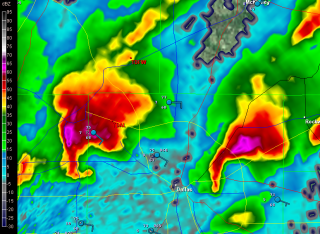
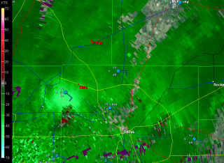
Now that all the excitement is over, here are a couple radar grabs from shortly after 3:00 p.m. EST (1903z) of two tornadic supercells moving across Dallas. Click on the images to enlarge them.

I was on the phone with my brother Brian at the time when I took the screenshots. He, my sister-in-law, Cheryl, and my nephew, Sam, live on the eastern side of Dallas. Worried about their safety, I gave Brian a call. It occurred to me that, once the storms had passed, Brian might enjoy seeing a couple of the radar shots that had prompted my concern.

The storms fired when moist, easterly surface winds collided with an old, eastward-moving outflow boundary. There’s plenty of lift and helicity in that combination, and with good instability and adequate upper-air support, supercells and tornadoes were the result. The event was extremely well-covered, as you’d expect when a major city is in the crosshairs in this age of live streaming and hi-def camcorders. Facebook was abuzz with chatter and images as the scenario unfolded.

But it’s all finished, and now we wait for official surveys to fill us in on the full scope of storm damage. From the videos and photos I’ve seen, some of the tornadoes were quite large, but for all that, it sounds like their impact was relatively minor. Of course, in the neighborhoods where homes got damaged or destroyed, it was calamitous, but considering what could have been, Dallas suffered a flesh wound, not a severed limb. So far I haven’t heard reports of any injuries or fatalities; let’s hope that continues to be the case.

One irony of this event is that it falls on a date that affords ample grounds for comparison. Thirty-eight years ago on April 3–4, the infamous 1974 Super Outbreak claimed 319 lives, a figure only recently surpassed by last year’s devastating April 27-28 Super Outbreak. One hundred forty-eight tornadoes raked a thirteen-state region in the East and South, and out of that number, six tornadoes were rated an F5 and twenty-four, an F4. Even the 2011 Southern Outbreak, violent, deadly, and prolific as it was, didn’t rival that statistic, although it certainly came very close.

Dallas today saw nothing like the disasters that unfolded back then in Xenia, Ohio; or Brandenberg and Louisville, Kentucky; or Monticello, Indiana; or Guin, Alabama. That’s a good thing. Such benchmarks are not the kind you ever want your own town to challenge, particularly if your town is as large and populous as Fort Worth or Dallas.

If you want to get a fascinating and gripping retrospective on one facet of the 1974 Super Outbreak, spend a little time listening to these recordings of the blow-by-blow radio reportage from WHAS as the Louisville tornado moved through the city.

Or for a really eerie experience, turn up the volume and listen to this MP3 of the Xenia, Ohio, tornado as it approached and ultimately destroyed the apartment of a Xenia resident, who wisely abandoned his cassette recorder to seek shelter in the basement.

And that’s enough of that. It’s time for me to pull away from the computer and go practice my saxophone.

Last Day of March: A Retrospective on One Really Weird Month

Here on this Saturday afternoon, poised at the tipping point into April, I look back on the past month and think, “What the heck was that?” March 2012 has been the oddest March I can recall, and if it is exiting like a lamb, it is not a very nice lamb. But at least it’s behaving more the way I’d expect it to. The first half of the month took the end of an abnormally warm winter to outlandish extremes, with record-breaking high temperatures across much of the nation. Here in West Michigan, not only did we consistently experience temps in the 70s, but we had a number of 80-degree days, one or two of which climbed perilously close to the 90-degree mark. For a while, it looked like we were emerging from the winter-without-a-winter into the summer-without-a-spring.

It was ridiculous, and to me, alarming. What kind of spring, to say nothing of summer, did such an anomaly presage? Would the nation wind up with another killer heat dome like last year’s, only maybe worse? Would the southern plains bake once again under an intolerable drought?

With the Gulf of Mexico’s moisture conveyor wide open, the lamb-like warmth of early March fostered some particularly leonine severe weather on March 2 in southern Indiana, Kentucky, Ohio, and other nearby states. It was the most lethal March tornado disaster since the 1966 Candlestick Park tornado claimed 42 lives.

As the warm spell continued, wildflowers bloomed in the woods a month ahead of schedule. Maples exploded into chartreuse and red blossoms, hyacinths decked themselves out in yellow, cherries and other flowering trees put on their finery, and hepaticas, spring beauties, and trout lilies sprinkled the forest floors with color, all weeks ahead of their normal season.

Now here we sit with flowers blooming and trees leafing out, and today’s temperature is forecast to hit the low 50s. Yesterday we almost got snow. The unseasonable warmth left us a week or so ago, and now March is acting like itself. Except, what’s with all these daffodils and pink plum blossoms?

The severe weather also seems to have regressed, which I suppose is just as well. I’m presently eyeballing what looks to be the next major trough, which according to today’s 6z GFS will swing into the plains Friday. At present, Saturday looks to have better potential, but at 180-plus hours out, there’s obviously a whole lot of wait-and-see involved between now and then. The system that is presently working its way through looked similarly promising a week ago, but it rapidly deteriorated into a poster child for why anything beyond three days out is just a prompt, not a forecast.

Anyway, right now, on this last day of March, I’m peering ahead and wondering: next Saturday, April 7? Maybe. Granted, I was entertaining similar speculations last week about tomorrow’s no-show. Still, it’s nice to have hit that time of year when the wildflowers are blooming, the robins are tugging worms out of the turf, and fools like me are once again gazing into the long-range crystal ball and thinking, “Hmmm…”

“We Had No Warning”

Welcome to tornado season 2012. It’s a reception that anyone but a storm chaser would no doubt prefer to decline, but there’s no getting around it. This abnormally warm March has already produced one prolific and deadly outbreak as well as several lesser tornado events. The Gulf conveyor is open for business, shuttling rich moisture into large sections of the continental United States, and with one system after another moving across the heartland, we appear to be moving into another active spring.

So let’s talk about what it will take to survive. If you’re a storm chaser, a National Weather Service or media meteorologist, or someone involved in emergency management, you can skip this post as it’ll be preaching to the choir. But if you’re the average John or Jane Doe, listen in:

On days when severe weather is imminent, YOU are responsible for remaining alert as if the lives of you and your family members depend on it–because that could very well be the case.

After virtually every tornado disaster, some survivor invariably repeats the age-old mantra, “We had no warning.” Journalists love it. Someone–the National Weather Service, emergency management, or somebody somewhere entrusted with safeguarding the public–failed to warn an unsuspecting community of looming danger. Once again, those charged with protecting lives and property failed miserably.

It makes great press, but it’s rarely true today. There are exceptions–the outrageous warning dereliction on the part of Saint Louis International Airport officials on Good Friday of last year comes to mind. Most of the time, though, the real problem is one of two things, or both:

  1. * people didn’t receive a warning in the manner they believed it should have come to them; or
  2. * they failed to take seriously the warnings that were issued.

Let’s consider each of these concerns.

People’s expectations of how they will be warned don’t match the reality of how warnings are disseminated.

.
I’ll preface the following discussion by saying that I am no operational forecasting expert. My knowledge is that of a layman, albeit an informed one, a storm chaser of over fifteen years’ experience, including, for the past year, serving as a media chaser for WOOD TV8. With that caveat dispensed with, let me begin by saying that virtually no significant severe weather event escapes the notice of the Storm Prediction Center (SPC) or National Weather Service (NWS) meteorologists. I’m not referring to rogue episodes that confound even the experts. Unforecastable events such as last week’s three tornadoes in eastern Michigan may have a devastating local impact, but they’re not in the same league as classic tornado outbreaks, which are preceded by conditions that meteorologists are able to monitor long before they ever mature. Potential severe weather events are normally scrutinized days in advance, and broadcast media such as The Weather Channel begin talking about them well ahead of time.

Big weather is invariably well-forecasted weather; the question is whether people pay attention to the forecasts. As a severe event moves toward day one, warning meteorologists do their utmost to heighten public awareness. With the advance of social media, weather watches and warnings go out through a wider variety of means than ever–TV, local radio, NOAA weather radio, civil defense sirens, Twitter, Facebook, media websites, and more. All that can be done is being done to disseminate timely, life-saving information to as many people as possible. Moreover, in a day when funds continue to be cut from its budget, the NWS continually strives to improve its warnings. The people there take their role as weather guardians very seriously.

The rest is up to the public. That’s you. It’s a matter of personal responsibility.

On days when severe weather is forecast–particularly when your area lies in or near a moderate or a high risk, and above all when a PDS (Particularly Dangerous Situation) has been issued–it is critically important that you maintain situational awareness.

If a credible source repeatedly warned you that your house was being targeted for a robbery one or two days hence, would you go about your life as usual when the day arrived? Of course not. You would be in a state of heightened alert and ready to take immediate action. That should be your stance on severe weather days. A tornado can take more from you in seconds than a whole busload of thieves can in an entire afternoon.

Don’t count on the tornado siren to sound. It may not if the power grid has been knocked out. Or you may not hear it if you’re too far away from it, or if it’s 3:00 a.m and you are sound asleep. Even if you hear the siren, you may not respond to it appropriately if you live in an area that gets warned frequently, to the point where residents have grown jaded from warning burnout. In any case, a civil defense siren is only one means of receiving warnings, and–take note–you should not depend on it as your primary source. Watch your local TV station, or check out their website, their Facebook updates, or their Twitter feeds. Or tune in to local radio. You have more warning options available to you today than ever before. Make use of them.

A NOAA WEATHER RADIO SHOULD BE AS STANDARD IN YOUR HOME OR OFFICE AS SMOKE ALARMS.

IF YOU DON’T HAVE ONE, GET ONE.

It’s 2:00 a.m., and you and your family are sound asleep. Throughout the day, TV meteorologists had been forecasting impending severe weather after dark, and later in the evening, a steady stream of severe thunderstorm and tornado warnings began to interrupt the programming. With your town lying on the eastern side of a tornado watch, you were concerned enough that you thought you’d remain awake for a while after everyone else went to bed, just in case.

But by midnight, the warnings were still off to your west by several counties. It was late, and you needed to be at work at 8:00 a.m. “Besides,” you told yourself, “nothing ever happens around here.” As you headed to bed, you noticed lightning flickering in the distance through the window, but it was still a long way off.

Now, two hours later, you and your family are all sleeping soundly as a violent, half-mile-wide tornado grinds across your neighborhood toward your house. You won’t be going to work in the morning after all.

Don’t let it happen. Outfit yourself with a weather radio. It’s one of your best weather-warning assets any time of day, and at night it’s your only line of defense. It can make a life-or-death difference for you and your loved ones.

Many people don’t take warnings seriously.

.
When the siren sounds, take cover. When the broadcast meteorologist or the weather radio tells you to seek shelter, do so. Unless you’re knowledgeable about how storms behave and have an informed grasp of exactly what the weather is doing relative to your location, head immediately for safety. Don’t go outside and gawk at the sky. Far too many tornado victims become statistics because they want to take a look before they take action. But tornadoes can materialize in seconds, and ones that are in progress can descend on you as swiftly as a hawk on a rabbit. While some may move at a turtle’s pace, others, particularly those in the early spring, may be racing along at 60 or 70 miles an hour or even faster. By the time your untrained eyes have informed you that you need to seek shelter, it may be too late. So don’t waste time–go to the basement or whatever safe place you’ve earmarked for severe weather. You do have such a place in mind, right? If not, take some time to plan where you’ll go.

Do not ignore warnings. Maybe you live in a place where you’ve gotten a lot of warnings that never materialized. The siren sounded time and again, but nothing happened. The warnings on TV and radio were all Doppler-based, containing language like, “A storm capable of producing a tornado is moving toward …” No matter. Take every warning seriously. Otherwise, the warning you ignore will be the one you’ll wish you had paid attention to.

Warning meteorologists are caught in a double-bind when it comes to radar-based warnings. When mets issue warnings based on radar-indicated circulation, they get accused of crying wolf when nothing happens. But if they fail to issue warnings because they lack ground proof, that’s when a tornado will drop out of the sky and wipe out a neighborhood, and the residents will complain that they had no warning.

Damned if they do and damned if they don’t: that’s the no-win scenario that warning meteorologists have to deal with. Since they are more concerned with protecting you and your family than they are with upholding their image, and since they are very good at interpreting radar data in the light of environmental conditions, they will rather play it safe than sorry. But the NWS and SPC, which continue to explore technological and sociological ways to improve the warning system, can only do so much; and your local broadcast meteorologists can only do so much. The rest is up to you.

Your safety is in your own hands.

.
It’s up to you to take warnings seriously and respond to them promptly. On days when severe weather has been forecast, it’s up to you to maintain a level of alertness that will enable you to take life-saving action even if you never hear a siren, see a warning on TV, or receive a tweet on your smartphone.

This year, more people are going to die in tornadoes. Some of the deaths may be unavoidable. When a large, violent tornado moves through a heavily populated area, as happened last year in Tuscaloosa, Alabama, and Joplin, Missouri, fatalities will sometimes occur even when people do everything right. But most deaths will be ones that could have been avoided had people taken proper precautionary actions.

Pay attention to the weather that is shaping up for your area days in advance. Equip yourself with a dependable means of receiving weather updates, including a weather radio for your home that can sound an alert 24/7. Take every warning seriously, respond to it immediately, and remain in your place of safety for as long as necessary.

THE RESPONSIBILITY IS YOURS. STAY SAFE THIS TORNADO SEASON.

March 15, 2012, Dexter and Lapeer, Michigan, Tornadoes

Thursday’s tornadic supercells in eastern Michigan took a lot of people by surprise–NWS and media meteorologists, the SPC, storm chasers, and certainly me. Nothing about those anemic mid- and upper-level winds suggested the potential for even weak tornadoes, let alone significant ones. But there’s no arguing with Nick Nolte’s fabulous footage of the Dexter tornado, and certainly not with the damage that storm did as it swept through the town. It has been rated an EF-3, the most damaging of the three tornadoes reported on March 15, 2012. Second in impact was a tornado that struck farther north in Lapeer, causing EF-2 damage; and finally, an EF-1 tornado in Ida.

Like every other chaser in Michigan whom I know, I had no plans for chasing storms Thursday. True, temps were in the 70s and dewpoints in the 60s; MLCAPE was in the order of 3,000–3,500 J/kg; and the hodograph looked curvy.

But curvy alone isn’t supposed to cut it, not when the dynamics are as puny as they were: winds around 20 kts at 850 mbs; 20–25 kts at 700 mbs; and 25–30 kts from 500 mbs on up to around 26,000 feet, where they finally began to make incremental but hardly impressive gains. The storms that formed should have been popcorn cells that quickly choked on their own precipitation. But they didn’t. At least some of them became classic supercells that lumbered across eastern Michigan at around 15 miles an hour, spinning up strong tornadoes.

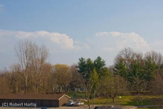
I was sitting in my living room editing a book manuscript shortly after 5:00 when I happened to glance out the window and saw some impressive, well-formed towers to my southeast. “Dang!” I thought. “Those look nice!” My second thought was to grab my camera and snap a few photos. After all, thunderstorms just aren’t something you normally see on March 15 in Michigan, let alone such muscular-looking ones. You can view one of the three shots I took–the last one, time-stamped 5:22 p.m.–at the top of the page. (Click on the image to enlarge it.)

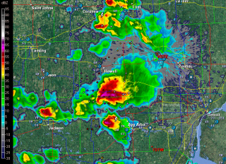
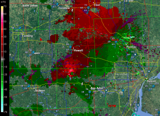
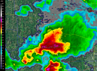
Curious, I took a look at GR3. I’d been glancing at it off and on as the afternoon progressed, watching a small squadron of cells pop up across southern and eastern Michigan. They resembled something I might normally see in July or August. But now, one of them looked different–so unexpectedly different that I had a hard time believing what I was seeing. South of Howell and northwest of Ann Arbor, the most vigorous-looking storm of the bunch had transformed into an unmistakable supercell–a regular flying eagle with a little pinhole BWER in the hook.

Where the heck did that come from, and why on earth was it there? Pinch me, I must be dreaming. I switched to SRV, and sure enough, there was a couplet, and not just a weak one, either. A pronounced couplet.

A scan or two later, the storm was continuing to develop. The pinhole had disappeared, and the supercell now had a classic hook. On radar, it looked as nice as anything you could hope to see out West in May–only this was Michigan in mid-March.

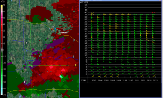
Surely the winds had to be better than I had been led to believe. One way to find out. I pulled up the VAD wind profiler at DTX. Ummm … well, okay. Nothing at all remarkable there. Maybe, given the curviness, enough bulk shear to organize the storm. Obviously that had to be the case; the evidence was staring me in the face, along with a couplet which hinted at the tornadic action that was presently occurring. The last screen capture, just below and to your right, shows both the couplet and the VAD. Enlarge the image, zoom in on it, and you can see for yourself just how meager the winds were and why one would expect storms forming in that environment to drown themselves in their own tears.

While I was glued to my radar in Caledonia, across the state storm chaser Nick Nolte was hot on the storm and videotaping the tornado that eventually hit Dexter. After getting out of work for the day, Nick had noticed the storm popping near where he lives. Grabbing his gear, he took off on what turned out to be one of the most serendipitous chases any chaser could hope for.

Nick got some fantastic footage of the Dexter tornado. Congrats, Nick–you really nailed it! Rather than steal Nick’s thunder by embedding his YouTube video here, I’m going to simply redirect you to his site and let you hunt it up there.

I’ve viewed some other footage beside Nick’s that demonstrates a particularly noteworthy aspect of the Dexter tornado, and that is its breakdown into helical vortices. I’ve seen only one other video that demonstrates this helical structure so clearly, and that is the famous KARE TV helicopter video of the July 18, 1986, Minneapolis tornado. The Dexter footage isn’t as dramatic, but it nevertheless depicts the helical effect with stunning and captivating clarity. Nick’s video captures it as well toward the end of his clip. It’s really amazing to see.

Unfortunately, the Dexter and Lapeer storms did considerable damage. If there’s a bright side to their human impact, it’s that no one was killed or seriously injured.

What turned yesterday’s anemic setup into a significant tornado-breeder? A weak upper-level impulse provided the needed lift to spark the storms, but it doesn’t explain why some of them developed into tornadic supercells, given the lackluster mid- and upper-level winds. I’m no expert, but I’m guessing that the unseasonably high CAPE is what did the trick. I suspect it took what was present in terms of shear and helicity and amplified it, in effect creating the Dexter, Lapeer, and Ida storms’ own mesoscale environments–ones conducive to tornadoes.

Of course, similar scenarios typically provide no more than single-cell and multicell severe storms. But then, yesterday was an anomaly in some significant ways. After all, this is Michigan, and it’s only mid-March. When CAPE of that magnitude shows up in the midst of unseasonably high dewpoints, it appears that all bets are off.

ADDENDUM: Lest you should miss reading the comments, check out this satellite loop from Thursday. You can see the storms exploding along an outflow boundary pushing west-northwest from Ohio, and other storms firing along a cold front dropping southeast. Two boundaries, and they actually appear to collide around Saginaw. The OFB accounts nicely for convergence and low-level helicity. Thanks to Rob Dewey for sending me the link.

March 12, 2012, West Michigan Supercell

Well, what do you know! My purely speculative ruminations a few days ago on some possible upcoming severe weather materialized. The NAM, which was odd-man-out among the various forecast models, proved in the end to have the best handle on today’s setup in terms of moisture and instability. Those mid-50s dewpoints it kept promising actually showed up–I took a read of over 56 degrees in Portage on my Kestrel–and so did sufficient instability, courtesy of clearing that allowed the sun to work its mojo over West Michigan.

Here was the setup, in brief:

• A mid-level low over Wisconsin directing southwesterly upper flow over Michigan.

• Diffluence overspreading the lower part of the state.

• A 70-knot 500 mb jet max nuzzling into the area.

• Below it, 45-knot 850 mb winds continuing to strengthen.

• A clear slot moving in from Illinois, breaking up the overcast from earlier storms into a nice cumulus field with room for decent insolation.

• From those same earlier storms, wet ground that contributed to the boundary-layer moisture.

• Adequate instability. From the afternoon’s SPC mesoscale graphics, it looks like we saw upwards of 500 J/kg MLCAPE–in the early spring, sufficient to get the job done.

• Low-level helicity in the order of 200-250 m2/s2–easily enough for tornadoes, though none were reported.

I expected to leave my place in Caledonia and head south toward Kalamazoo around 3:00 p.m. However, clearing was moving into southwest Michigan so rapidly, with an attendant, juicy-looking cumulus field, that at 1:30 I could no longer sit still. I grabbed my gear, gassed up and Rain-Xed up, and hit the road.

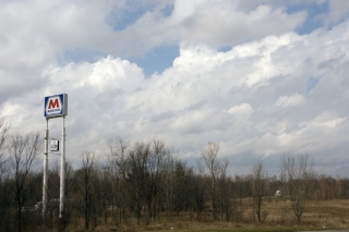
At the Marathon station on US-131 and 100th Street, I snapped a couple photos of the clouds while I waited for Tom Oosterbaan to arrive. In the topmost image, you can see how much shear was messing with the enhanced cumuli.

Once Tom arrived, we headed down US-131 toward Kalamazoo. On Center Avenue in Portage, south of I-94, we hooked up with Tom’s brother, Bill, and Dave Diehl. The four of us sat and waited, watching little storms on the radar pop along the lakeshore and head northeast and larger ones march across Grand Rapids and farther north.

Eventually, a vigorous cell that was moving in from around Benton Harbor continued to strengthen as it pulled closer to PawPaw. Cloud tops on this guy shot up rapidly as it moved toward us, and it began to take on that telltale supercellular look. This was our baby.

Bill took off west to intercept it directly in PawPaw. Tom and I headed north back up US-131, then caught M-43 west toward Bangor. A few miles down, a turbulent updraft base came into view. It was moving our way fast, and we decided that the better approach would be to jet back to 131, head north, and catch the storm as it approached and crossed the highway.

WOOD TV8 contacted me before we hit the exit ramp, and with my live stream going, a live phone-in underway, and an optimal view of a robust-looking wall cloud with a rather impressive tail cloud advancing from my west, pulling over onto the shoulder of the ramp seemed like my best move at that point. I did, and from what I hear, the live stream turned out really nicely on television.

As the wall cloud drew nearer, I took off once again, and we drew near to its southern edge as it crossed the highway, attended by a precip-filled RFD notch starting to wrap around it.

The storm was tearing along, and as it moved off to the northeast, I had a hunch that our day was over. We tried hard to catch up with the storm again, but it was moving too fast. Bill, on the other hand, had repositioned well off to the east and was in a prime location to intercept it. He did, and followed it a long way east. How he managed to keep up with it during its course through rural Barry County, which is some of the most unchaseable terrain imaginable, I’ll never know. (Actually, I probably do know–I’ve been on a lot of chases with Bill–but I ain’t divulging his secret, not me.)

After flirting briefly with another cell that blew toward us from Plainwell, Tom and I headed back toward 100th Street, where I dropped him off at his vehicle and then headed home.

This was a fun little local chase–less than 200 miles and nothing spectacular, but full of interest and a really nice way to kick off the spring storm season in West Michigan. Just for grins, here is a brief video clip of the wall cloud as it passed over US-131.

Stormy Monday in Michigan?

The Storm Prediction Center’s Day Three Convective Outlook has stamped lower Michigan with a “See Text” attended by the following discussion:

A POCKET OF COLD
TEMPERATURES AT MID LEVELS…MINUS 18-20C AT 500 MB…WILL SPREAD
ACROSS LOWER MI JUST NORTH OF A FOCUSED SPEED MAX. THIS FEATURE
WILL LIKELY INDUCE DIURNALLY ENHANCED CONVECTION AS 50F+ SFC DEW
POINTS SURGE NWD WITHIN THE WARM CONVEYOR. LATEST FORECAST
SOUNDINGS SUGGEST SFC-BASED CONVECTION IS POSSIBLE WITHIN A STRONGLY
SHEARED ENVIRONMENT THAT WOULD OTHERWISE FAVOR SUPERCELL
DEVELOPMENT. GIVEN THE SOMEWHAT LIMITED BOUNDARY LAYER MOISTURE
ACROSS THIS REGION WILL NOT INTRODUCE HIGHER SEVERE PROBS ATTM.
HOWEVER ANY UNDERESTIMATION IN LOW LEVEL MOISTURE WILL LEAD TO A
MORE UNSTABLE AIR MASS THAT WOULD SUGGEST AN INCREASED RISK OF
SEVERE FROM EXTREME NRN IND/NWRN OH INTO LOWER MI.

Hmmm…okay, that’s worth looking into, and I have done so. The NAM surface map is more optimistic about moisture than the GFS and SREF, wanting to bring in mid-to-upper-50s surface dewpoints, and therein lies the possibility for severe, from what I can see.

Today’s 12z 250 mb 4km NAM also shows a 70 knot jet streak moving into the area on top of 35-40 knot 850 mb winds, and GFS is in better agreement with the shear than it is the moisture.

Earlier on, I also sampled a few 6z Bufkit NAM soundings using RAOB, and these show impressively curved hodographs–a different story from TwisterData’s point-and-click hodos–as well as dewpoints tapping on 60 degrees. That seems pretty exuberant, particularly in the light of other forecast models, but it does give me at least this take-away wisdom: Monday bears keeping an eye on. If, as the SPC states, decent moisture manages to infiltrate lower Michigan, then we could be in for some severe storms.

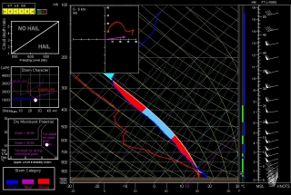
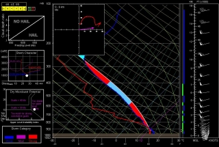
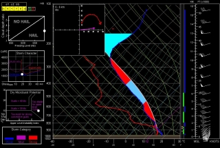
Just for kicks, below are the aforementioned RAOB forecast soundings for Monday evening taken from this morning’s 6z NAM run, along with the 4km NAM 250 mb map. The soundings are for Kalamazoo, Jackson, and Fort Wayne. Take them with a grain of salt, but let’s see how things shape up (or not) between now and then.

KALAMAZOO, MI

JACKSON, MI

FORT WAYNE, IN

250 MB WINDS (FCST 21Z)