As I Greet the Next Decade: Reminiscences on Thirteen Years of Storm Chasing

Happy New Year, everyone! Welcome to a brand new decade.

With multiple possibilities for my first blog post in the year 2010, I find myself contemplating a recent thread on Stormtrack, and, in the light of it, reminiscing about my own development as a storm chaser.

The thread started with a newbie chaser asking forum members’ opinions about what constitutes a “veteran chaser.” The guy took a bit of a bashing initially, but to me his question seemed innocent, reflecting honest curiosity rather than a preoccupation with labels or a need to earn some sort of merit badge, and it made for an interesting discussion.

And, as I’ve said, it got me to reflecting on my personal path. One by one, the chase seasons have connected to each other like boxcars on a train. It seems incredible to think that 2010 will mark my fourteenth year chasing storms. If years alone were what it took to make a person a veteran chaser, then I might qualify.

But years alone do not a veteran make–at least, not in my opinion. A veteran road warrior, yes; a veteran storm chaser, no. There are plenty of people who have been chasing a shorter time than me, but who have acquired far more skill and experience. As for me, I’m just a slow but happy learner who’s too low-key to mess with light bars.

However, the span of time I’ve been chasing has allowed me some formative experiences I probably wouldn’t have had if I had started more recently. Today, it seems like the average neophyte steps into the field equipped, if not with knowledge, at least with a laptop, GR3, GPS, and an aircard. He or she has a technological edge that didn’t exist, or that barely existed, back when I was getting started.

I now realize that the simplicity and constraints of those first, low-tech years have left me with a gift of memories. I treasure those thousands of miles I traveled–sometimes by myself, sometimes with Bill and/or Tom Oosterbaan–equipped with nothing more than a weather radio, a portable black-and-white TV set, high hopes, and an eye on the sky.

Radar? I stopped at local libraries and airports and got my fix. I had no idea how long a radar image would be good for, how much difference four-and-a-half minutes and a single scan could make. Today I just shake my head and think, no wonder I never saw any tornadoes. It’s a wonder I managed to see a stinkin’ cloud.

As for forecasting, that consisted of looking at SPC outlooks and then steering for the middle of a moderate or high risk area. At some point, though, I discovered my first link to a site for forecasting models, and an interesting–and daunting–new window opened up. Suddenly, here was a bewildering suite of data–surface dewpoints, BRN shear, CAPE, lifted indices, helicity, 300 mb winds…alchemy, pure alchemy, and in a variety of flavors at that. GFS. ETA. RUC. Hoo boy, talk about dumping a load on my head!

Around that same time, I attended my first severe weather conference at College of DuPage. As I recall, Chuck Doswell conducted a workshop on hand analysis and Eric Rasmussen shared some findings from the first Project Vortex. By then, I knew just enough acronyms and concepts to make sense out of some of what was getting thrown at me. Much of the value lay simply in being exposed to the actual stuff of operational forecasting and severe weather research. There’s something to be said for sheer exposure; even if a body grasps just a fraction of the concepts he encounters, what matters is, it’s a start. I left that conference, and the one that followed it a year or two later, equipped with a little more awareness and a little less ignorance than I had coming in.

My first successful tornado intercept occurred in my first season as a chaser, in 1996, in my home state of Michigan. A wall cloud formed directly south of my workplace, and I left work early to chase it sixty miles to where it put down a beautiful tube out in the open countryside near St. Johns. The storm was a classic supercell, as nice as anything I’ve seen out on the Great Plains, though at the time I had no ground for comparison and knew nothing about storm modes or morphology.

It would be another ten years before I witnessed my next tornado in 2006, as Bill and I tracked the historic Six State Supercell from west of Columbia, Missouri, all the way back to Michigan. Prior to that, I had roamed my state and neighboring Indiana, and pounded the flatlands of Illinois, with just a handful of wall clouds and a growing awareness of storm structure to show for it. The year 2005 was my first excursion across the Mississippi and my first experience watching storms explode along the dryline in central Kansas.

But 2006 was the year when things finally started coming together for me, and I think that Bill–my consistent chase partner for all these years–would say the same, since our personal learning curves have been closely tied together. By then we were using Bill’s business laptop and had access to NOAA radar. I had just discovered the significance of velocity couplets, although, not yet understanding the benefit of using storm relative velocity over base level velocity, I was using the latter. Again, it was a start, and the base level gave us enough data to keep us from very likely getting blown off the road by the Springfield, Illinois, tornado as Bill and I chased the Six State Supercell.

A month later, we intercepted tornadoes in Iowa, including another large, night-time tornado that did F2 damage in Iowa City.

That same year, I acquired my own laptop, and the following spring I added GR3, and from there on, my learning and experience curve began to snowball. Today, as I look at where I started and where I’m now at, I realize that I’ve learned a few things. I’ve gained another great chasing partner in my buddy Kurt Hulst. I’m making my own forecasts with increasing knowledge and accuracy. I haven’t seen a lot of tornadoes, but I’ve seen my share, and I trust that, by God’s grace, I’ll see more, as well as endure more busts and make more idiotic choices that cost me storms I could have had.

So, getting back to the question of what makes a veteran chaser, I’m firsthand proof that there’s more to it than just the number of years a person has been chasing storms. In my opinion, there are actually three components to being a veteran storm chaser:

1. Really, really knowing what the heck you’re doing,

2. Many years of doing it, and

3. Lots of successes and lots of failures to show for it.

I probably fulfill the second criterion. As for the other two, well…I’ve got a ways to go, but I’m working on them. Give me another ten years and maybe the hat will fit. It really doesn’t matter, though. As a general rule, chasers who are worth their salt don’t give a flip about labels. They’re driven by storms, not status. Certain names are indeed revered–icons such as Tim Marshal, David Hoadley, Roger Edwards, and Gene Moore. As for the rest of us mortals, I think that those who’ve been at it a for a while respect others who have paid their dues. We know the names, if not the actual faces, and recognize the shared passion and personal investment behind those names. The countless miles traveled. The commitment to learning and growth.

Above all, the love for the storms that keeps us dreaming all through the winter, and that, in the spring, calls us once again toward the open skies, the tumbled clouds, and the hope and promise of the Plains.

[XUB6K3AQNFKD]
Blue Moon on New Year’s Eve

They call it a “blue moon”–a second full moon in the same month. It’s a rare occurrence in itself, but tonight’s blue moon will be all the more unusual because it’s occurring on New Year’s Eve. Now we’re talking about a REALLY rare event–once every 20 years, in fact.

But wait–it gets even better. This blue moon will also undergo a partial eclipse. Don’t get too hopped up about it, though. If you live in the northern hemisphere, you won’t be seeing it. Elsewhere in the world, though, in places far removed from my little old hometown of Caledonia, Michigan, sky watchers will get to witness the whole shebang: a blue moon eclipsing on New Year’s Eve.

Those of us who reside in Michigan, on the other hand, will be lucky if we get to see the moon at all. With snow in the forecast, it’s highly unlikely we’ll get so much as a fleeting glimpse.

Too bad. I was looking forward to seeing a New Year’s Eve blue moon. I hate to think I’ll have to wait another 20 years before I get my next crack at one.

Maybe there’ll be a rift in the clouds, just long enough to offer a quick glance.

My heart is hopeful and my fingers are crossed.

Ghosted Notes on the Saxophone

When you’ve been playing the saxophone for a long time, it’s easy to forget how certain techniques that have become an organic part of your playing once were mysteries to you. So it was for me with ghosted notes–aka ghost notes, aka ghost tones–back in my college days. I heard certain sax players punctuating their solos with notes treated with a sudden reduction in sound volume that made it seem as if they had been swallowed. It was a very cool effect, but I didn’t know what it was called, and darned if I could figure out how to duplicate it.  One thing was clear: it involved something other than merely adjusting my airstream.

I finally asked fellow alto man Tom Stansell, who used the technique with excellent effect, what it was he was doing and how he did it. Tom quickly filled me in, and the mystery that had been eluding me turned out to be no mystery after all. Within a few minutes during my next practice session, I had a pretty good handle on the technique.

If you’ve never ghosted a note on the sax before, then here’s your opportunity to learn how. What Tom passed on to me, I now pass on to you.

How to ghost a note on the saxophone

Ghosting a note on the sax is simply a matter of tongue placement during articulation. In normal articulation, you separate notes by applying your tongue to the reed dead on, temporarily cutting off air from the mouthpiece and preventing the reed from vibrating. But by applying your tongue to only one corner or side of the reed while maintaining your airflow, you effectively dampen just a part of the reed while allowing the rest of it to vibrate.

That’s all there is to it.

Repeat: to ghost a note, simply touch just a side or corner of the reed with your tongue.

Of course, you’ll refine the technique and personalize your application of it over time, but the above is all you need to get started.

Now the next time you’re playing through a chart and you come across a note or group of notes enclosed in parentheses–the standard notation for ghosting–you’ll know how to treat it.

Unlike circular breathing or double tonguing, note ghosting offers a rare opportunity for instant gratification in a saxophonist’s learning curve, and it’s a very effective tool to have in your musical toolkit. You’ll love how a handful of well-placed ghost notes adds interest and character to your playing.

That’s all, folks. Be sure to check out my jazz page for more helpful articles and saxophone solo transcriptions.

How Will El Nino Affect the Tornado Season in 2010?

Have you wondered what ramifications this present El Nino has for the 2010 tornado season? I have. At first I was excited to think of all that winter precip bringing relief to the parched South, removing drought from the equation and enhancing the moisture fetch in the spring. Now, however, I’m wondering whether that advantage won’t be offset by other concerns.

Not being a climatologist, or even modestly astute in matters of climatology, the best I can do is speculate, and my speculation is probably fraught with misinformation (aka bullcrap). Nevertheless, after looking at the Climate Prediction Center’s December 21 update of their ENSO report, I can’t help trying to make some sense of it as it pertains to storm chasing.

The report makes it clear that the present El Nino is intensifying, with sea surface temperatures (SSTs) now averaging 1.2 C above normal in the eastern Pacific.

no images were found

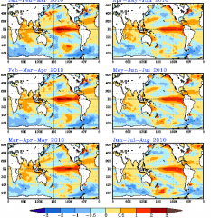
The six charts on page 28 of the report depicting projected sea surface temperatures caught my eye. I’ve included them here. Click on the image on the right to enlarge it.

As you read the charts, notice the following:
* Panels 3 and 4 (March-May and April-June) show above-average SSTs in the eastern Pacific, pooling significantly off of Baja.
* Slightly lower-than-average SSTs preside in most of the GOM.
* Panel 5 (May-July) shows warmer temperatures finally moving toward the coast of the GOM.
* With the June-August map, the GOM seems to be in good shape, and the SST anomaly off of Baja appears to be modifying.

What I make of this picture is that subtropical moisture from the southwest (i.e. the subtropical jet) may play a bigger-than-usual role in the springtime weather, while Gulf moisture return may be delayed. That’s not a very promising scenario for this coming storm season.

Again, I am NOT a climatologist, and all of the above is just my clumsy attempt to piece together stuff I’m aware of but don’t really understand. So chances are good that my reasoning is out in left field, and if that’s the case, then more knowledgeable heads than mine are free to correct me. I’m not attempting to make a long-term prognosis here so much as I’m simply processing information, trying to understand the big picture.

I’ve already posted on this topic in Stormtrack, in the hope of generating some discussion and gaining insight into the matter. If I glean some gems of wisdom, then a follow-up post here on Stormhorn.com  may be in order. For that matter, if you’ve got a better handle on the picture than I do, then please comment here and and set me straight. Believe me, I won’t mind being wrong.

A Christmas Meditation on Jesus

Can it really be that I’ve experienced 53 Christmases?

Magical Christmases of my childhood, filled with anticipation and Santa Claus and toys. Conspiratorial Christmases of my older boyhood, wherein, having been initiated into the truth about Santa, I now assisted my parents in the clandestine placement of gifts under the tree. Teenage Christmases, tinged with both family warmth and family struggles. So many Christmases.

As I write, I’m wrestling with a nasty chest cold and am not in the frame of mind to write a lengthy, well-worded post. So I thought I’d share something with you from the past.

The following is something I wrote two years ago on Christmas Eve, 2007, in my MySpace blog. Many things have changed since then. Significantly, my beautiful best friend, Lisa, has entered my life, and I am no longer alone. But the essence of what I had to share back then hasn’t changed, not for me and very likely not for you, my reader. Without wasting more words, then, I give you…


Christmas Eve. As an older single male, age fifty-one and counting, I’m spending it alone.

I would like to say that in reality, I am not alone—and really, that is the case. My Lord is with me. Jesus.

But when it comes to polishing off a large bowl of chili (heated to a well-seasoned glow by a sub-lethal dose of Dave’s Insanity Sauce), followed by a generous helping of spaghetti, all designed to take the edge off a bottle of 9 percent ABV old ale and another bottle of 11.5 percent Trappist ale…well, the work has been strictly mine. No one sits with me in my humble, though comfortable, apartment to make supper and the partaking of craft brew a shared effort. I am by myself—as are many who will read these words.

Yet, as I have said, He is here. Here in these modest digs of a solitary, middle-aged male. And because He is here with me, I trust He is also there with you, wherever you are, whatever your circumstances may be. Some of you are grieving the loss of a loved one. Others are simply experiencing, like me, another “single” Christmas Eve by yourself. You have friends, and if you’re fortunate, you have family, and you’re thankful. But there’s still something missing, isn’t there?

It’s all right. He is here with you and me. Emmanuel, “God with us.” And in a strange way, those of us who feel sorrow, or loneliness, or a poignant emptiness in this Season of Light, may be closest of all to the heart and soul of what Christmas is truly about.

For you see, that little baby who was born into the lowliest of circumstances two thousand years ago didn’t come for the sake of inspiring cozy traditions, or warm exchanges of gifts by the fireside, or happy family meals. No. Those things are wonderful, and I wouldn’t detract from them for anything. But their absence in the lives of so many of us lies closer to the reason Jesus was born. He came not because this world is so wonderful, but because it was, and is, so broken. He came for those of us who long for a place called “home.” He came for the lonely, for the disenfranchised, for less-than-perfect you and me who know firsthand the meaning of loss, and tears, and struggle; who long for something more in life. He came to give us that “something more.” He came because he knows how deeply we long—and need—to be truly, safely, securely, and lastingly loved.

I write with all the freedom that a couple bottles of high-potency ale can inspire, tempered by my editorial instincts and guided by my heart, which is consumed with Him. But who is He? In this day of well-publicized “new discoveries” of the same tired old heresies that have sought for centuries to recreate a more convenient Jesus, the marketplace of ideas abounds with options.

I just Googled the name “Jesus,” and on the first page of search results I find the following:

* three full-color graphic images of Jesus

* a Wikipedia article

* a “Christmas Jesus Dress Up”

* a YouTube clip of Jesus singing “I Will Survive”

* an online Catholic encyclopedia article on Jesus

* a  BBC news article that begins, “A statue of the infant Jesus on display near Miami in Florida is being fitted with a Global Positioning System device after the original figurine was stolen.”

Clever, all very clever. But when you’re alone on Christmas Eve, cleverness doesn’t really cut it, does it? For so many of us who are by ourselves tonight, the one thing we long to know is that we’re really not alone. The older we get, the more that matters.

So perhaps, after we’ve wearied our clever minds exploring all the alternatives, the Jesus of the Bible really is what we’re looking for after all—because of all the gods available in today’s spiritual shopping mall, He is the only one who has come looking for us in a way that is consistent with someone who cares not about religion, but about us. To  be born in our midst and commit a lifetime to experiencing everything about the human condition, from inglorious start to brutal finish, certainly smacks of a genuine and very personal investment.

Christmas is God’s way of acknowledging what all of us instinctively know (though we try so hard to argue otherwise): that this world is fractured, splintered. That we are lonely. That we are lost. That we long for something more.

Christmas is God’s way of saying, “My loved ones have lost me, and I have lost them. And that is unacceptable to me.”

This Christmas…you are not alone. I am not alone.

Jesus came for us.

If you’ve screwed up your relationships, Jesus came for you.
If you’ve been sexually abused, Jesus came to clothe you with dignity and hope.
If you’re lonely, He came to give you a place at the family table.
If you’ve been betrayed or abandoned, He came to hold you gently with arms that will not be removed.
If you’re_______, He came to fill in the blank with something better than emptiness.

This Christmas…we are deeply loved.

So to you, my friends, however you may believe and whatever your circumstances may be…

May He fill this time with the reality, the glory, and the comfort of Himself…

Have a blessed Christmas.

Storm

The First Day of Winter

As far as East Coasters are concerned, with 26 inches of snow falling on Long Island in yesterday’s blizzard, winter has already arrived. For that matter, here in Michigan, you’d be hard put to convince anyone otherwise when it comes to the practical sense of the word winter. Look outside and what do you see? Snow, and lots of it. Sure looks like winter to me, and has looked that way for a good month.

But today at 12:57 a.m. EST–less than three hours from now as I write these words–winter will become official. That is the precise minute of the winter solstice, the time when the sun reaches its southernmost position over the Tropic of Capricorn and begins its journey back north. From then on, the slow but steady pilgrimage toward spring will be underway.

In my hometown of Caledonia, according to my sunrise/sunset calendar, the sun rose today at 8:09 a.m. and will set at 5:11 p.m. EST. That gives us nine hours and two minutes of daylight on the shortest day of the year. From this point, we’ll struggle a bit trying to add those extra, tiny increments of daylight. The sun will set a little later each day, but it will also continue to rise a little later for a while, nibbling away another four minutes of dawn until January 7. That’s the day when, after tipping above the horizon at 8:13 a.m. for seven days straight–the sun will finally rise at 8:12. We’ll have added a minute in the morning and, by then, 14 minutes in the evening–a total of 15 minutes. By the end of January, we’ll have gained 58 minutes of  daylight.

Gray and cold though today may be, with a light snow falling steadily outside my deck door, winter solstice is nevertheless a welcome landmark. Its frozen arrival portends the lengthening of light and the certainty of spring. And this one comes with a visit from my brother Patrick, whom I haven’t seen in several years. It’s wonderful to see him; a more welcome Christmas gift I couldn’t ask for.

Whatever the winter brings–and with a strong El Nino in force, it could be a doozy for many–today is the time when the forces that conspire to create snow, ice, and bitter cold begin to lose their logistics. Winter’s batteries may presently be charged to the max, but the countdown to storm season is about to begin.

The Trouble with Reading Glasses: A Jazz Saxophonist’s Lament

Reading glasses suck.

No, let me restate that: Reading glasses are a boon, but having to wear them sucks. And it particularly sucks, sucks to the fourth power, when one is trying to read big band charts on a bandstand.

Am I the only horn player who has this problem? I seriously doubt it.

I go through reading glasses like they’re M&Ms chocolate-covered peanuts. I buy them, lose them, buy them, lose them. So I get the cheapest ones I can find–I mean, reeeaally cheap, $1.99 glasses which I purchase at Ace Hardware in Hastings. They do the job just fine for most purposes, but playing in a big band is not “most purposes.” It’s a purpose set apart that poses some peculiar problems.

For one thing, those classy, low-slung bandstands which are so much a part of the big band tradition place the music a couple feet away and well below my natural line of vision. I compensate by scroonching forward and down in a manner that would inspire admiration in a circus contortionist.  This gets me closer to the music, allowing me to read it.

Most of it, that is. There comes a point, as I approach the bottom of a chart, where the music dips below the frame of my glasses, and I’m confronted with a decision whether to scroonch even farther–and believe me, four hours of scroonching in this manner does nothing to improve either my posture or my attitude–or else attempt to read the remainder of the page without the assistance of lenses.

Now, my vision isn’t so bad that option B isn’t feasible, at least in theory, but a funny–though not knee-slappingly so–thing happens when I attempt it: I lose my place in the music.

This leaves me frantically scrambling to find my place while the rest of the band chugs merrily onward. Eventually, Eric or Hugh or whoever is playing tenor next to me points to a spot on my chart, and I dive back in with varying levels of success, depending on my familiarity with the arrangement. It’s frustrating and embarrassing.

Life would be so much easier if I could trade the bandstand for a good, old-fashioned music stand which adjusts easily for height and distance. Get those charts right smack in front of my eyeballs, where I can read them without the aid of a telescope, and I’d be fine. But no, that’s not how it works, not with a big band, where low-rise bandstands are integrally woven into the mystique.

That, my friends, is why I emerge from big band gigs with the posture of a Cheeto. Reading-glasses-induced scroonching is doing me in.

I may be a well-maintained 53 years old, but I’m still 53. That’s not old enough yet to qualify as a curmudgeon, but there are times when I come pretty close, and an entire evening of imitating a hunchback is one of them.

So why do I continue to put up with the frustrations and, in all seriousness, the physical discomfort? Because I enjoy playing the music. I’m not primarily a big band musician; my natural habitat, where I really spread my wings and fly, is small combos. But I came up through big bands, and I’m glad for the opportunity to still play the great old arrangements from time to time. I mean, you can’t get a better jazz education than you’ll find in the music of Duke and Basie, you know? That’s why I continue to pay the cost of tuition.

There’s no problem with the library, none whatever. I just wish I could find some reading glasses that would enable me to read the books without a hitch from cover to cover.

Forecast Model Simulations for 1965 Palm Sunday Tornadoes: Part 2

The drive down to the WFO at State College, Pennsylvania, was well worth my while (see my previous post). Operational forecaster and research meteorologist David Beachler was a pleasure to work with–personable, patient, and eager to help me understand the exhaustive forecast simulations he had produced on the 1965 Palm Sunday Tornadoes. Having pored over the data with David, gaining his insights on its strengths and weaknesses, I am now extremely excited about what I’ve got on my hands.

David’s modeling uses the WRF-ARW 40 km. The resolution is too coarse to offer the fine details that the SPC is capable of producing, but it gives an excellent overall feel of what forecasters and storm chasers might see in the models if the Palm Sunday synoptic setup were to unfold today instead of forty-five years ago in 1965.

no images were found

There’s no way I can begin to cover all the material, which in any case I need to sift through in order to put together a reasonably concise and meaningful scenario. But I can at least give you a sample of some of the stuff I’ve got to work with. Click on the following images to enlarge them.

First, here is a hand analysis of the kind that is accessible to anyone through NOAA’s historical daily weather maps archives. Besides the surface map for April 11, 1965, you also get the previous day’s surface map, 500 mb chart, and other info. It’s what you would have encountered when you turned to the weather page in the newspaper that morning.

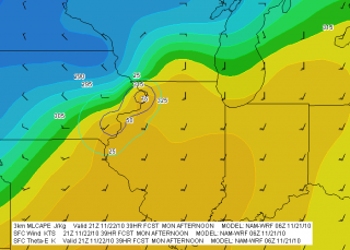
What you would never have seen–because parameters such as CAPE, CIN, helicity, and so on didn’t exist back then, and because even if they had existed, the forecast models which could have depicted them were still years down the road–is this map showing SBCAPE and low-level shear.

The map is for 2200Z, or 6 p.m. EST–roughly the time at which tornadoes began moving through northern Indiana.

It gets even better. Here is a model sounding for KGRR, also at 2200Z, using WRF-ARW Bufkit data. The skew-T and hodograph depict the conditions that were shaping up to produce the F4 Alpine Avenue tornado that formed

around 6:50 p.m., as well as other tornadoes in west and southwest Michigan that day. The helicity is impressive–and look at those winds! Forty knots at 850 millibars is no mere puff of air.

What really excites me is that, using RAOB’s cross-section feature, I should be able to reconstruct a vertical profile of the atmosphere for the entire outbreak area. I’m not sure how deeply I want to go with that, but I have the capacity.

Bear in mind that I’m just showing a couple of representative glimpses derived from a 00Z, day-one model initiation. In fact, David provided me with a range of initiation times that allows me to get a good sense of how the maps might have progressed from several days prior to the actual tornado outbreak.

In practical terms, the maps and model sounding data I’ve got correlate to the NAM. They’re not the NAM, but for storm chasers who typically work with the GFS, ECMWF, GEM, NAM, and RUC, what you see here is probably closest to what you’d find using the North American Mesoscale Model.

That’s all for now. This has been a time-consuming post, and at 2:30 in the afternoon, I need to pull away from it so I can bathe and eat. I didn’t arrive home until 3:00 a.m., so it’s time for this road warrior to reset his time clock and get on with the rest of life.

Forecast Model Simulations for 1965 Palm Sunday Tornadoes: Part 1

Today I’m making the trip to State College, Pennsylvania, where I’ll be overnighting and then meeting tomorrow with operational and research meteorologist David Beachler at the CCX National Weather Service office.

Earlier this year–thanks to John Laurens at KGRR, who contacted him on my behalf–David took such forecasting data as exists on the 1965 Palm Sunday Tornadoes and ran it through a computer. (That’s putting it quite simply, I’m sure.) The result is a veritable blizzard of hourly model simulations which I’m hoping to narrow down to something that can give me new insights into the second worst Great Lakes/Midwest tornado outbreak of modern times. If all goes well, one of the results well be an engaging scenario for the storm chasing community.

Of course, a project of this nature will take some refining. The first hurdle is my own ignorance as a non-meteorologist. It’s one thing for a layman like me to use forecast models in identifying target areas for storm chases; it’s another thing to understand the whys and wherefores of those models.

A second challenge is to sift through the accuracy of the data, since we’re talking about a massive amount of extrapolation from a paucity of decades-old source material; and a third is to distill the immensity of info that David has provided into a reasonably straightforward, meaningful synopsis.

What I’m hoping for, in the end, is a series of surface and upper-air charts that can answer the question, “If the same synoptic conditions that produced the Palm Sunday Tornadoes unfolded today, what might we see in the models from a few days out until the time when tornadoes started dropping?”

This project has been in the wings for a while as part of a larger project which I’m keeping mum about for now. I want to get this part taken care of first, and I’m excited that I’m finally getting to meet with David and go over the data with him, so I can better understand how to interpret it and narrow down a selection from it that will be most useful. I’m extremely appreciative of David’s work, and his willingness to help me sift through it.

Gotta go. I need to hit the road in a couple hours. Here’s hoping for good driving.

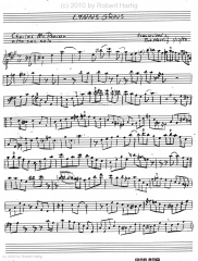
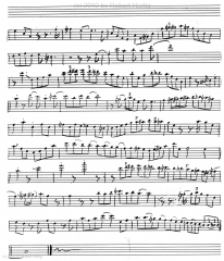
Lynn’s Grins: A Charles McPherson Alto Sax Solo Transcription

Ready for another saxophone solo transcription? “Lynn’s Grins” by alto saxophonist Charles McPherson is one of my favorites. It’s a concert C blues (alto key of A) at a medium-fast tempo, and it features McPherson in full cry, showing the listening world that he knows a thing or two about bebop. (Click on the images to enlarge them.)

From his simple opening statement outlining the tonic triad, McPherson plunges headlong into a millrace of ideas, toying at times with outside colors but always staying within the basic framework of the parent key.

There’s plenty to pick up on from this solo, and the best way to do so is by getting to work on it. What are you waiting for? Get cracking!